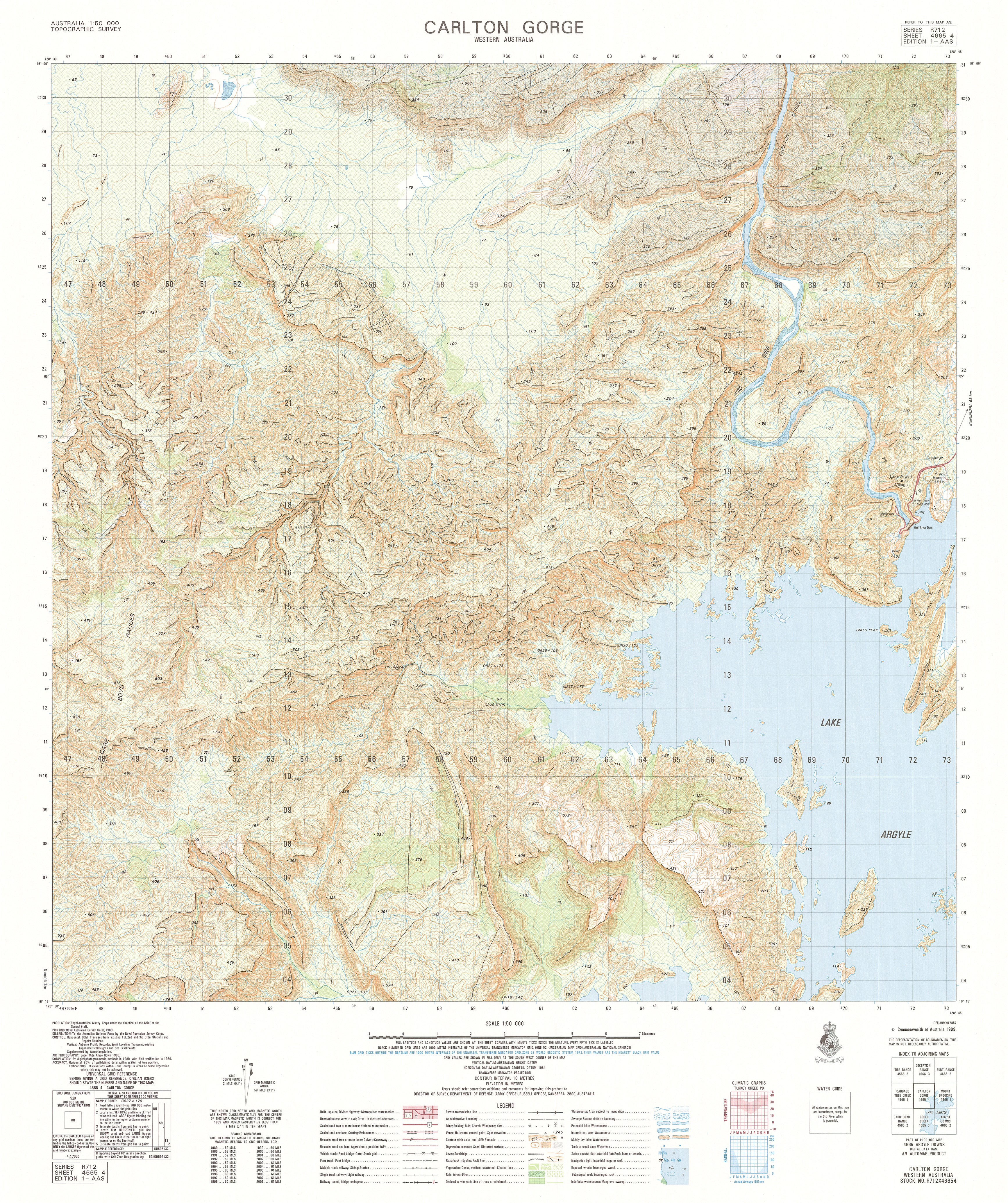
4665-4 Carlton Gorge 1:50k Topographic Map
4665-4 Carlton Gorge — 1:50,000 Topographic Map
The 4665-4 Carlton Gorge 1:50,000 topographic sheet provides detailed, high-clarity mapping across a dramatic inland landscape shaped by steep gorges, rugged ridgelines, dissected slopes, rocky terraces, creek valleys and extensive pastoral country. Produced under Australia’s national 1:50k mapping program, this sheet delivers the precise terrain intelligence relied upon by emergency responders, environmental consultants, surveyors, engineers, land managers and experienced outback explorers.
Contours, hydrology, vegetation, cultural features and access networks follow Australia’s standardised topographic symbology, ensuring consistent interpretation for planning, assessment and field navigation.
🗺️ Map Content & Features
At 1:50,000 scale — 1 cm = 500 m, the Carlton Gorge sheet includes:
-
Contours & Elevation: steep gorge walls, rugged ridges, dissected hill slopes, undulating plains and spot heights
-
Hydrology: Carlton Gorge Creek system, tributaries, ephemeral drainage lines, seasonal pools and floodout pockets
-
Transport & Access: unsealed roads, rugged 4WD tracks, pastoral routes, station access roads and remote trails
-
Cultural & Built Features: homesteads, tanks, windmills, yards, outstations, survey points and named features
-
Vegetation & Land Cover: rangeland scrub, sparse woodland, riparian vegetation, rocky terrain and open plains
-
Administrative & Grid Framework: boundaries, coordinate grids and national mapping standards
-
Optimised for steep and rugged terrain: ideal for technical navigation, environmental analysis and operational planning
🧭 Who Uses This Map?
The Carlton Gorge 1:50k sheet is used by:
-
Emergency services & SES — rugged-access evaluation, hazard assessment, search and rescue planning
-
Environmental consultants & scientists — geological mapping, hydrology, habitat and vegetation studies
-
Surveyors & civil engineers — terrain modelling, corridor feasibility, infrastructure planning
-
Pastoral operators & land managers — muster planning, asset assessment, boundary and land-use review
-
Recreational users — 4WD explorers, hikers, canyon walkers, remote-area travellers
-
Researchers & educators — geomorphology, upland landscape studies, environmental field teaching
💧 Field-Ready Print Options
✅ Waterproof & Tear-proof Tyvek®
-
Printed on genuine DuPont™ Tyvek®
-
Fully waterproof, tear-resistant and UV-stable
-
Foldable like paper — ideal for steep, rocky and remote environments
✅ Laminated Edition
-
Encapsulated in 2 × 80-micron gloss laminate
-
Write-on / wipe-clean function for whiteboard markers
-
Compatible with Mapworld map dots
-
Extremely durable — resists heat, moisture, dust and repeated rugged handling
📄 Standard Paper Edition
-
High-resolution print
-
Suitable for office planning, documentation, reference libraries and map archives
📐 Map Details
| Field | Details |
|---|---|
| Title | 4665-4 Carlton Gorge |
| Series | Australia 1:50,000 Topographic Series |
| Scale | 1:50,000 (1 cm = 500 m) |
| Coverage | Carlton Gorge region — steep gorges, ridges, plains, ephemeral drainage & pastoral land |
| Coordinates | Geographical & UTM |
| Datum | AGD66; later editions WGS84; AHD elevations |
| Projection | Universal Transverse Mercator (UTM) |
| Currency | Maps published 1968–2006 |
| Sheet Size | 600 mm (width) × 710 mm (height) |
| Material Options | Paper • Laminated • Tyvek® |
| Printed In | Australia |
🛒 Ordering & Options
-
Folded paper edition — compact, economical and travel-ready
-
Waterproof Tyvek® edition — ideal for rugged, steep and remote back-country terrain
-
Laminated edition — write-on/wipe-clean, excellent for technical planning and repeated field use
🎯 Summary
The 4665-4 Carlton Gorge — 1:50,000 Topographic Map offers essential mid-scale mapping across a rugged upland environment dominated by steep gorges, broken ridges and narrow creek systems. With detailed contours, hydrology, vegetation mapping and durable print options, this sheet is indispensable for emergency responders, surveyors, environmental scientists, land managers and adventurous outback travellers.
Work clearly.
Plan confidently.
Navigate precisely.
Original: $14.27
-65%$14.27
$4.99Product Information
Product Information
Shipping & Returns
Shipping & Returns
Description
4665-4 Carlton Gorge — 1:50,000 Topographic Map
The 4665-4 Carlton Gorge 1:50,000 topographic sheet provides detailed, high-clarity mapping across a dramatic inland landscape shaped by steep gorges, rugged ridgelines, dissected slopes, rocky terraces, creek valleys and extensive pastoral country. Produced under Australia’s national 1:50k mapping program, this sheet delivers the precise terrain intelligence relied upon by emergency responders, environmental consultants, surveyors, engineers, land managers and experienced outback explorers.
Contours, hydrology, vegetation, cultural features and access networks follow Australia’s standardised topographic symbology, ensuring consistent interpretation for planning, assessment and field navigation.
🗺️ Map Content & Features
At 1:50,000 scale — 1 cm = 500 m, the Carlton Gorge sheet includes:
-
Contours & Elevation: steep gorge walls, rugged ridges, dissected hill slopes, undulating plains and spot heights
-
Hydrology: Carlton Gorge Creek system, tributaries, ephemeral drainage lines, seasonal pools and floodout pockets
-
Transport & Access: unsealed roads, rugged 4WD tracks, pastoral routes, station access roads and remote trails
-
Cultural & Built Features: homesteads, tanks, windmills, yards, outstations, survey points and named features
-
Vegetation & Land Cover: rangeland scrub, sparse woodland, riparian vegetation, rocky terrain and open plains
-
Administrative & Grid Framework: boundaries, coordinate grids and national mapping standards
-
Optimised for steep and rugged terrain: ideal for technical navigation, environmental analysis and operational planning
🧭 Who Uses This Map?
The Carlton Gorge 1:50k sheet is used by:
-
Emergency services & SES — rugged-access evaluation, hazard assessment, search and rescue planning
-
Environmental consultants & scientists — geological mapping, hydrology, habitat and vegetation studies
-
Surveyors & civil engineers — terrain modelling, corridor feasibility, infrastructure planning
-
Pastoral operators & land managers — muster planning, asset assessment, boundary and land-use review
-
Recreational users — 4WD explorers, hikers, canyon walkers, remote-area travellers
-
Researchers & educators — geomorphology, upland landscape studies, environmental field teaching
💧 Field-Ready Print Options
✅ Waterproof & Tear-proof Tyvek®
-
Printed on genuine DuPont™ Tyvek®
-
Fully waterproof, tear-resistant and UV-stable
-
Foldable like paper — ideal for steep, rocky and remote environments
✅ Laminated Edition
-
Encapsulated in 2 × 80-micron gloss laminate
-
Write-on / wipe-clean function for whiteboard markers
-
Compatible with Mapworld map dots
-
Extremely durable — resists heat, moisture, dust and repeated rugged handling
📄 Standard Paper Edition
-
High-resolution print
-
Suitable for office planning, documentation, reference libraries and map archives
📐 Map Details
| Field | Details |
|---|---|
| Title | 4665-4 Carlton Gorge |
| Series | Australia 1:50,000 Topographic Series |
| Scale | 1:50,000 (1 cm = 500 m) |
| Coverage | Carlton Gorge region — steep gorges, ridges, plains, ephemeral drainage & pastoral land |
| Coordinates | Geographical & UTM |
| Datum | AGD66; later editions WGS84; AHD elevations |
| Projection | Universal Transverse Mercator (UTM) |
| Currency | Maps published 1968–2006 |
| Sheet Size | 600 mm (width) × 710 mm (height) |
| Material Options | Paper • Laminated • Tyvek® |
| Printed In | Australia |
🛒 Ordering & Options
-
Folded paper edition — compact, economical and travel-ready
-
Waterproof Tyvek® edition — ideal for rugged, steep and remote back-country terrain
-
Laminated edition — write-on/wipe-clean, excellent for technical planning and repeated field use
🎯 Summary
The 4665-4 Carlton Gorge — 1:50,000 Topographic Map offers essential mid-scale mapping across a rugged upland environment dominated by steep gorges, broken ridges and narrow creek systems. With detailed contours, hydrology, vegetation mapping and durable print options, this sheet is indispensable for emergency responders, surveyors, environmental scientists, land managers and adventurous outback travellers.
Work clearly.
Plan confidently.
Navigate precisely.