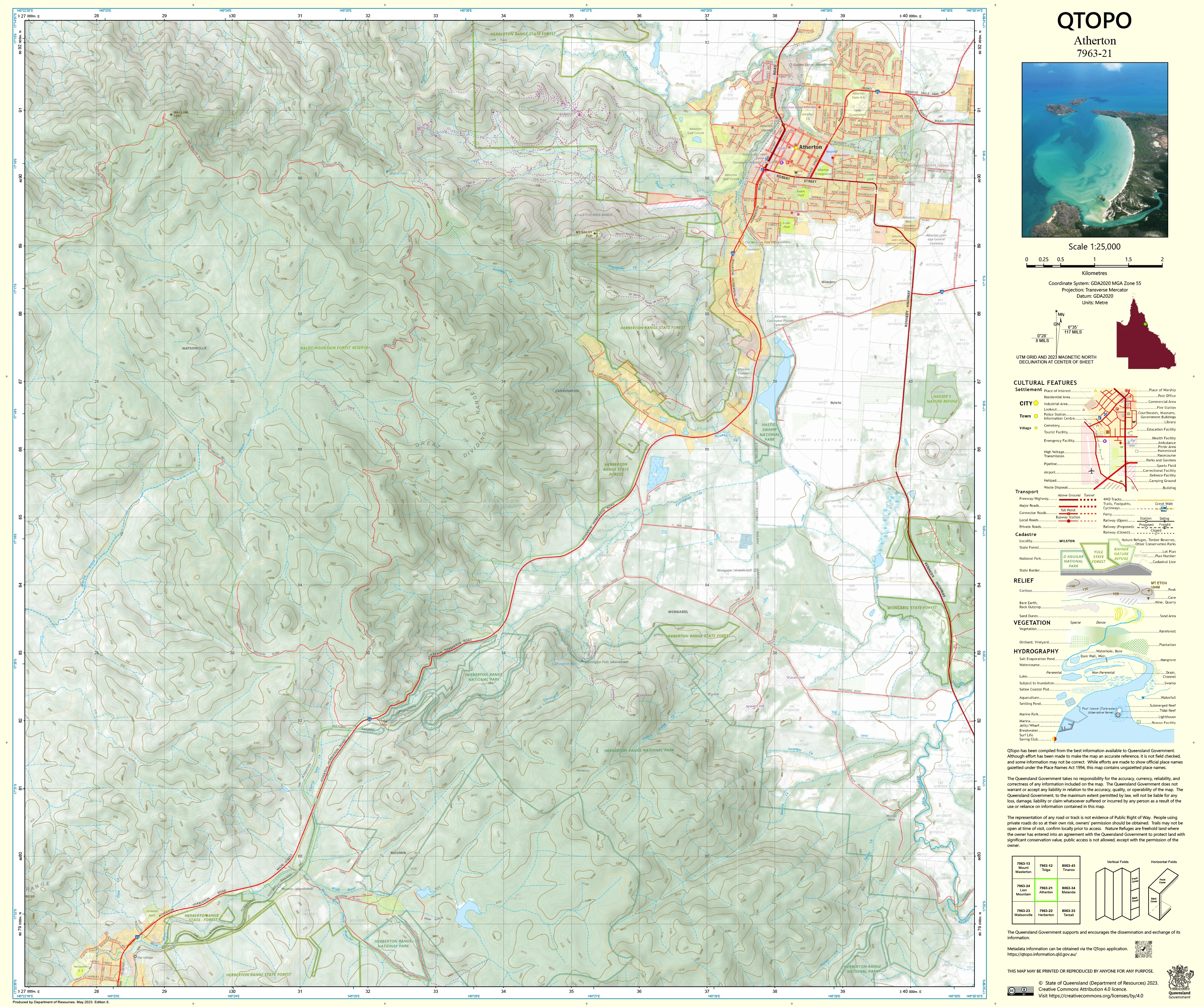
7963-21 Atherton QTopo 1:25,000 Topographic Map
QTopo 7963-21 — Atherton
1:25,000 Topographic Map
A high-precision, field-ready topographic map for navigating the rolling farmland, forest reserves, volcanic tablelands, and rural landscapes surrounding Atherton, one of the key townships of the Atherton Tablelands in Far North Queensland.
The QTopo 7963-21 (Atherton) sheet—produced by the Queensland Department of Resources—is part of the state’s authoritative 1:25,000 mapping series. Known for its fertile volcanic soils, patchwork agriculture, rainforest remnants, and gently undulating uplands, the Atherton region demands accurate, modern cartography for land management, ecological fieldwork, infrastructure planning, and outdoor exploration.
Whether you're conducting environmental surveys, working rural land, planning infrastructure, or navigating local 4WD and access routes, QTopo 7963-21 provides the clarity and reliability essential for informed decision-making.
🗺️ Map Content and Features
Rendered at 1:25,000 scale—where 1 cm = 250 m—this map delivers detailed, terrain-focused cartography including:
-
Contour lines showing Atherton’s rolling hills, ridgelines, volcanic formations, and gentle upland gradients
-
Hydrology: creeks, springs, drainage lines, wetlands, irrigation channels, and farm dams
-
Roads, rural access routes, 4WD tracks & local pathways, including links between agricultural areas and forest reserves
-
Infrastructure such as homesteads, sheds, stockyards, communication sites, utilities, and service facilities
-
Vegetation mapping including rainforest fragments, woodland, open farmland, crops, and cleared grazing areas
-
Land tenure boundaries: freehold farmland, leasehold parcels, reserves, national park edges, and state land
-
Named natural features including tableland hills, depressions, creeks, volcanic remnants, and topographic markers
-
Points of interest relevant to farmers, ecologists, planners, and local explorers
All QTopo sheets are based on authoritative Queensland spatial datasets, ensuring accurate and consistent mapping.
🧭 Who Uses This Map?
The Atherton 7963-21 Topographic Map is relied upon by:
-
Rural landholders & agricultural operators – property planning, access, water management, and boundary awareness
-
Environmental scientists & ecologists – vegetation mapping, field surveys, and habitat assessments
-
Emergency services & SES – fire planning, flood modelling, and rural search & rescue
-
Surveyors, engineers & planners – infrastructure assessment and project design
-
Hikers, cyclists & local explorers – navigating rural backroads and natural features
-
Outdoor educators – teaching practical navigation on the Tablelands
A trusted and versatile tool for both professional operations and recreational navigation.
💧 Field-Ready Options for Tablelands Conditions
Choose the finish suited to Atherton’s mix of dry-season dust, wet-season downpours, and rugged rural use.
✅ Waterproof & Tearproof Tyvek®
-
Printed on DuPont™ Tyvek®, engineered for durability
-
Fully waterproof, tear-resistant, lightweight, and foldable
-
Perfect for rainfall, irrigation exposure, muddy boots, and long days in the field
-
Best option for rural operators and field ecologists
✅ Laminated Edition
-
Encapsulated in 2 × 80-micron gloss laminate
-
Writeable using whiteboard markers—ideal for planning, mapping routes, or training
-
Compatible with Map Dots for temporary marks
-
Durable, wipe-clean, and resistant to moisture and dirt
📄 Standard Paper Edition
-
Crisp, high-quality printing
-
Ideal for office use, planning, classrooms, or light fieldwork
📐 Map Details
Title: QTopo 7963-21 — Atherton
Publisher: Queensland Department of Resources
Series: QTopo 1:25,000
Scale: 1:25,000 (1 cm = 250 m)
Dimensions: Approx. 710 mm × 594 mm
Coverage: Atherton township surrounds, rural farmland, creeks, volcanic uplands, and nearby forest reserves
Material Options: Paper, laminated, or waterproof Tyvek®
Printed in: Australia
Edition: Latest available (see listing for publication year)
📥 QTopo Map Index
Need adjoining sheets across the Tablelands?
➡️ Check the QTopo index or contact us with adjacent sheet numbers—such as 7963-20, 7963-22, or 7863-31—and we’ll locate the correct maps instantly.
🛒 Ordering & Options
-
Standard folded paper map – great for planning and desk reference
-
Tyvek® waterproof edition – rugged, all-weather field durability
-
Laminated edition – reusable and ideal for workshops or operational planning
-
Flat (unfolded) maps available on request for wall-mounting
🎯 Summary
The QTopo 7963-21 — Atherton Topographic Map provides the essential terrain, hydrological, and access detail needed to work efficiently and navigate safely across one of the Atherton Tablelands’ most productive and varied regions. Its accurate 1:25,000 cartography and rugged print options make it indispensable for land managers, field professionals, and local explorers.
Plan with purpose.
Navigate with confidence.
Explore with clarity.
Choose your preferred finish today and take Atherton into the field with Queensland’s most trusted topographic mapping.
Original: $28.58
-65%$28.58
$10.00Product Information
Product Information
Shipping & Returns
Shipping & Returns
Description
QTopo 7963-21 — Atherton
1:25,000 Topographic Map
A high-precision, field-ready topographic map for navigating the rolling farmland, forest reserves, volcanic tablelands, and rural landscapes surrounding Atherton, one of the key townships of the Atherton Tablelands in Far North Queensland.
The QTopo 7963-21 (Atherton) sheet—produced by the Queensland Department of Resources—is part of the state’s authoritative 1:25,000 mapping series. Known for its fertile volcanic soils, patchwork agriculture, rainforest remnants, and gently undulating uplands, the Atherton region demands accurate, modern cartography for land management, ecological fieldwork, infrastructure planning, and outdoor exploration.
Whether you're conducting environmental surveys, working rural land, planning infrastructure, or navigating local 4WD and access routes, QTopo 7963-21 provides the clarity and reliability essential for informed decision-making.
🗺️ Map Content and Features
Rendered at 1:25,000 scale—where 1 cm = 250 m—this map delivers detailed, terrain-focused cartography including:
-
Contour lines showing Atherton’s rolling hills, ridgelines, volcanic formations, and gentle upland gradients
-
Hydrology: creeks, springs, drainage lines, wetlands, irrigation channels, and farm dams
-
Roads, rural access routes, 4WD tracks & local pathways, including links between agricultural areas and forest reserves
-
Infrastructure such as homesteads, sheds, stockyards, communication sites, utilities, and service facilities
-
Vegetation mapping including rainforest fragments, woodland, open farmland, crops, and cleared grazing areas
-
Land tenure boundaries: freehold farmland, leasehold parcels, reserves, national park edges, and state land
-
Named natural features including tableland hills, depressions, creeks, volcanic remnants, and topographic markers
-
Points of interest relevant to farmers, ecologists, planners, and local explorers
All QTopo sheets are based on authoritative Queensland spatial datasets, ensuring accurate and consistent mapping.
🧭 Who Uses This Map?
The Atherton 7963-21 Topographic Map is relied upon by:
-
Rural landholders & agricultural operators – property planning, access, water management, and boundary awareness
-
Environmental scientists & ecologists – vegetation mapping, field surveys, and habitat assessments
-
Emergency services & SES – fire planning, flood modelling, and rural search & rescue
-
Surveyors, engineers & planners – infrastructure assessment and project design
-
Hikers, cyclists & local explorers – navigating rural backroads and natural features
-
Outdoor educators – teaching practical navigation on the Tablelands
A trusted and versatile tool for both professional operations and recreational navigation.
💧 Field-Ready Options for Tablelands Conditions
Choose the finish suited to Atherton’s mix of dry-season dust, wet-season downpours, and rugged rural use.
✅ Waterproof & Tearproof Tyvek®
-
Printed on DuPont™ Tyvek®, engineered for durability
-
Fully waterproof, tear-resistant, lightweight, and foldable
-
Perfect for rainfall, irrigation exposure, muddy boots, and long days in the field
-
Best option for rural operators and field ecologists
✅ Laminated Edition
-
Encapsulated in 2 × 80-micron gloss laminate
-
Writeable using whiteboard markers—ideal for planning, mapping routes, or training
-
Compatible with Map Dots for temporary marks
-
Durable, wipe-clean, and resistant to moisture and dirt
📄 Standard Paper Edition
-
Crisp, high-quality printing
-
Ideal for office use, planning, classrooms, or light fieldwork
📐 Map Details
Title: QTopo 7963-21 — Atherton
Publisher: Queensland Department of Resources
Series: QTopo 1:25,000
Scale: 1:25,000 (1 cm = 250 m)
Dimensions: Approx. 710 mm × 594 mm
Coverage: Atherton township surrounds, rural farmland, creeks, volcanic uplands, and nearby forest reserves
Material Options: Paper, laminated, or waterproof Tyvek®
Printed in: Australia
Edition: Latest available (see listing for publication year)
📥 QTopo Map Index
Need adjoining sheets across the Tablelands?
➡️ Check the QTopo index or contact us with adjacent sheet numbers—such as 7963-20, 7963-22, or 7863-31—and we’ll locate the correct maps instantly.
🛒 Ordering & Options
-
Standard folded paper map – great for planning and desk reference
-
Tyvek® waterproof edition – rugged, all-weather field durability
-
Laminated edition – reusable and ideal for workshops or operational planning
-
Flat (unfolded) maps available on request for wall-mounting
🎯 Summary
The QTopo 7963-21 — Atherton Topographic Map provides the essential terrain, hydrological, and access detail needed to work efficiently and navigate safely across one of the Atherton Tablelands’ most productive and varied regions. Its accurate 1:25,000 cartography and rugged print options make it indispensable for land managers, field professionals, and local explorers.
Plan with purpose.
Navigate with confidence.
Explore with clarity.
Choose your preferred finish today and take Atherton into the field with Queensland’s most trusted topographic mapping.