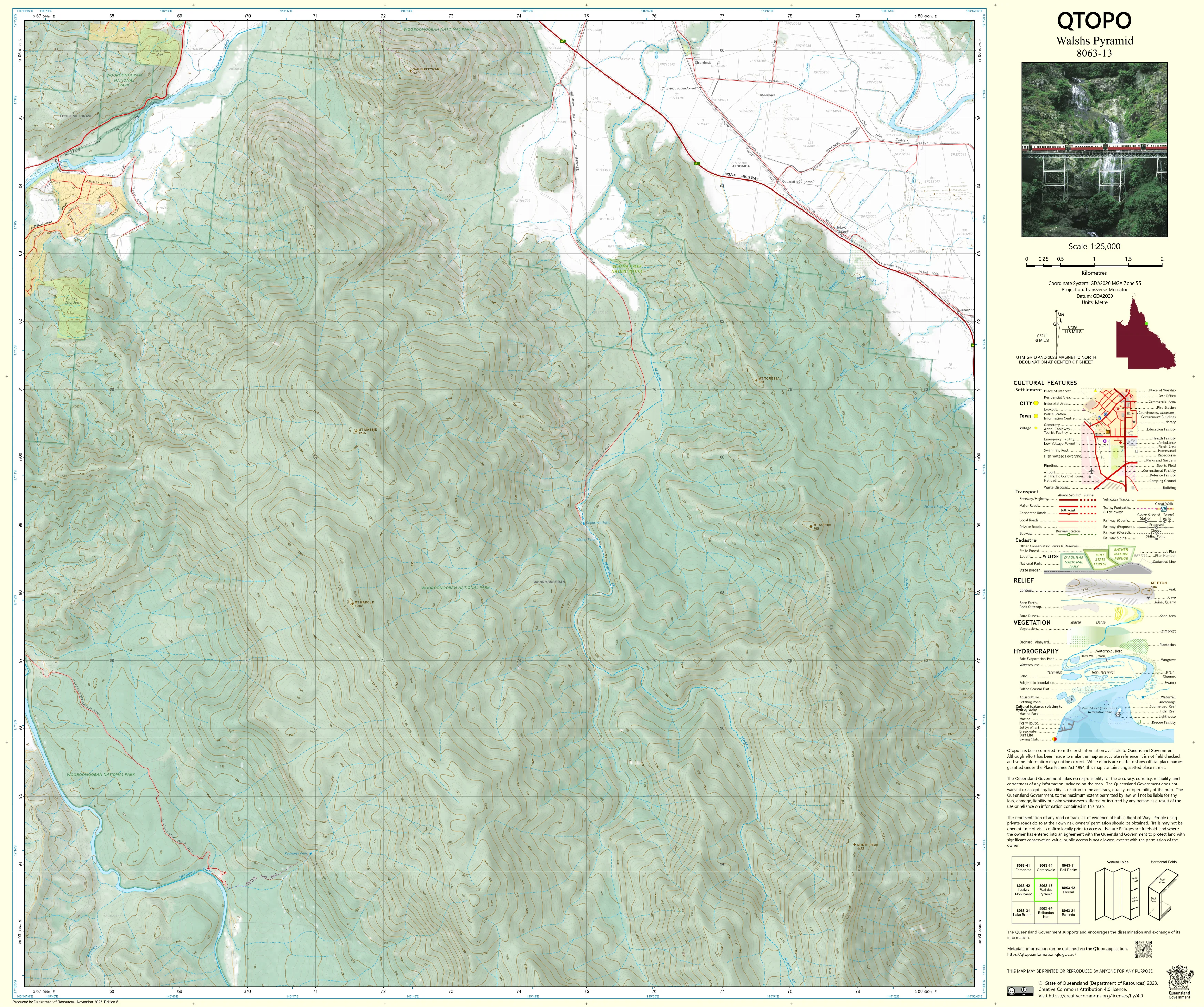
8063-13 Walshs Pyramid QTopo 1:25,000 Topographic Map
QTopo 8063-13 — Walshs Pyramid
1:25,000 Topographic Map
A highly detailed, field-ready topographic map for navigating the iconic Walshs Pyramid and its surrounding landscapes in Far North Queensland.
The QTopo 8063-13 (Walshs Pyramid) sheet—produced by the Queensland Department of Resources—is part of the official 1:25,000 QTopo mapping series. Famous for its near-perfect triangular profile and steep ascent, Walshs Pyramid stands as one of the most prominent and challenging natural landmarks south of Cairns. This map captures the mountain's rugged slopes, adjacent valleys, and surrounding rural and forested terrain with precision.
Whether you're preparing for the strenuous summit climb, conducting environmental fieldwork, managing land and access routes, or coordinating emergency services, QTopo 8063-13 delivers the reliable detail needed for accurate navigation and planning.
🗺️ Map Content and Features
At 1:25,000 scale—where 1 cm represents 250 m—this map provides detailed, high-resolution information, including:
-
Contour lines at fine intervals depicting the steep slopes and ridgelines of Walshs Pyramid
-
Hydrology features: creeks, drainage lines, waterholes, and seasonal waterways
-
Roads, 4WD tracks, fire trails & access routes, including approaches to the hiking trail and surrounding rural properties
-
Infrastructure such as buildings, powerlines, fencelines, communication assets, and local facilities
-
Vegetation mapping showing rainforest edges, woodland, open country, farmland, and cleared areas
-
Land tenure boundaries: state land, reserves, freehold properties, and managed parcels
-
Named natural features including peaks, knolls, gullies, flats, and local topographic markers
-
Points of interest relevant to walkers, land managers, researchers, and emergency teams
As with all QTopo products, this sheet uses consistent symbology and is generated from accurate, up-to-date Queensland spatial datasets.
🧭 Who Uses This Map?
The Walshs Pyramid 8063-13 Topographic Map is essential for:
-
Bushwalkers & hikers – planning and navigating the demanding ascent
-
Emergency services & SES teams – search and rescue readiness, fire planning, and response coordination
-
Environmental scientists & ecologists – performing vegetation and habitat studies
-
Surveyors, engineers & planners – terrain assessment for local development and infrastructure
-
Rural landholders & land managers – access, boundary awareness, and on-ground planning
-
Outdoor educators & navigation trainers – teaching map-reading and steep-terrain navigation
A trusted reference for both recreational and professional use in this high-relief environment.
💧 Field-Ready Options for Rugged Tropical Terrain
Select the format that suits the steep, humid, and weather-variable conditions around Walshs Pyramid.
✅ Waterproof & Tearproof Tyvek®
-
Printed on DuPont™ Tyvek®, engineered for extreme field durability
-
100% waterproof, tear-resistant, lightweight, and foldable
-
Ideal for rain, humidity, sweat exposure, and rugged handling during steep climbs
-
The preferred option for serious hikers and field teams
✅ Laminated Edition
-
Encapsulated in 2 × 80-micron gloss laminate
-
Writeable surface—great for whiteboard markers during route briefing or planning
-
Compatible with Map Dots for temporary marking
-
Wipe-clean, durable, and resistant to moisture, dirt, and abrasion
📄 Standard Paper Edition
-
Crisp, high-quality print
-
Ideal for office planning, study, classroom use, or occasional field reference
📐 Map Details
Title: QTopo 8063-13 — Walshs Pyramid
Publisher: Queensland Department of Resources
Series: QTopo 1:25,000
Scale: 1:25,000 (1 cm = 250 m)
Dimensions: Approx. 710 mm × 594 mm
Coverage: Walshs Pyramid, surrounding foothills, creeks, access routes, and nearby rural land
Material Options: Paper, laminated, or waterproof Tyvek®
Origin: Printed in Australia
Edition: Latest available (see listing for year)
📥 QTopo Map Index
Need adjoining sheets for broader coverage?
➡️ Refer to the QTopo index or contact us with sheet numbers—such as 8063-12, 8063-14, or 7963-23—and we’ll help you find the correct neighbouring maps instantly.
🛒 Ordering & Options
-
Standard folded paper map – perfect for planning and reference
-
Tyvek® waterproof edition – ideal for humid, steep, and unpredictable conditions
-
Laminated edition – tough, reusable, and excellent for group planning or training
-
Flat (unfolded) maps available for workshops or wall display
🎯 Summary
The QTopo 8063-13 — Walshs Pyramid Topographic Map delivers the detailed terrain, hydrological, and access information required to navigate and work safely in one of Far North Queensland’s most prominent and challenging natural landscapes. Its precise 1:25,000 cartography and durable print formats make it indispensable for hikers, researchers, and field professionals.
Plan with purpose.
Navigate with confidence.
Explore with clarity.
Choose your preferred finish today and take Walshs Pyramid into the field with Queensland’s most trusted topographic mapping.
Original: $14.27
-65%$14.27
$4.99Product Information
Product Information
Shipping & Returns
Shipping & Returns
Description
QTopo 8063-13 — Walshs Pyramid
1:25,000 Topographic Map
A highly detailed, field-ready topographic map for navigating the iconic Walshs Pyramid and its surrounding landscapes in Far North Queensland.
The QTopo 8063-13 (Walshs Pyramid) sheet—produced by the Queensland Department of Resources—is part of the official 1:25,000 QTopo mapping series. Famous for its near-perfect triangular profile and steep ascent, Walshs Pyramid stands as one of the most prominent and challenging natural landmarks south of Cairns. This map captures the mountain's rugged slopes, adjacent valleys, and surrounding rural and forested terrain with precision.
Whether you're preparing for the strenuous summit climb, conducting environmental fieldwork, managing land and access routes, or coordinating emergency services, QTopo 8063-13 delivers the reliable detail needed for accurate navigation and planning.
🗺️ Map Content and Features
At 1:25,000 scale—where 1 cm represents 250 m—this map provides detailed, high-resolution information, including:
-
Contour lines at fine intervals depicting the steep slopes and ridgelines of Walshs Pyramid
-
Hydrology features: creeks, drainage lines, waterholes, and seasonal waterways
-
Roads, 4WD tracks, fire trails & access routes, including approaches to the hiking trail and surrounding rural properties
-
Infrastructure such as buildings, powerlines, fencelines, communication assets, and local facilities
-
Vegetation mapping showing rainforest edges, woodland, open country, farmland, and cleared areas
-
Land tenure boundaries: state land, reserves, freehold properties, and managed parcels
-
Named natural features including peaks, knolls, gullies, flats, and local topographic markers
-
Points of interest relevant to walkers, land managers, researchers, and emergency teams
As with all QTopo products, this sheet uses consistent symbology and is generated from accurate, up-to-date Queensland spatial datasets.
🧭 Who Uses This Map?
The Walshs Pyramid 8063-13 Topographic Map is essential for:
-
Bushwalkers & hikers – planning and navigating the demanding ascent
-
Emergency services & SES teams – search and rescue readiness, fire planning, and response coordination
-
Environmental scientists & ecologists – performing vegetation and habitat studies
-
Surveyors, engineers & planners – terrain assessment for local development and infrastructure
-
Rural landholders & land managers – access, boundary awareness, and on-ground planning
-
Outdoor educators & navigation trainers – teaching map-reading and steep-terrain navigation
A trusted reference for both recreational and professional use in this high-relief environment.
💧 Field-Ready Options for Rugged Tropical Terrain
Select the format that suits the steep, humid, and weather-variable conditions around Walshs Pyramid.
✅ Waterproof & Tearproof Tyvek®
-
Printed on DuPont™ Tyvek®, engineered for extreme field durability
-
100% waterproof, tear-resistant, lightweight, and foldable
-
Ideal for rain, humidity, sweat exposure, and rugged handling during steep climbs
-
The preferred option for serious hikers and field teams
✅ Laminated Edition
-
Encapsulated in 2 × 80-micron gloss laminate
-
Writeable surface—great for whiteboard markers during route briefing or planning
-
Compatible with Map Dots for temporary marking
-
Wipe-clean, durable, and resistant to moisture, dirt, and abrasion
📄 Standard Paper Edition
-
Crisp, high-quality print
-
Ideal for office planning, study, classroom use, or occasional field reference
📐 Map Details
Title: QTopo 8063-13 — Walshs Pyramid
Publisher: Queensland Department of Resources
Series: QTopo 1:25,000
Scale: 1:25,000 (1 cm = 250 m)
Dimensions: Approx. 710 mm × 594 mm
Coverage: Walshs Pyramid, surrounding foothills, creeks, access routes, and nearby rural land
Material Options: Paper, laminated, or waterproof Tyvek®
Origin: Printed in Australia
Edition: Latest available (see listing for year)
📥 QTopo Map Index
Need adjoining sheets for broader coverage?
➡️ Refer to the QTopo index or contact us with sheet numbers—such as 8063-12, 8063-14, or 7963-23—and we’ll help you find the correct neighbouring maps instantly.
🛒 Ordering & Options
-
Standard folded paper map – perfect for planning and reference
-
Tyvek® waterproof edition – ideal for humid, steep, and unpredictable conditions
-
Laminated edition – tough, reusable, and excellent for group planning or training
-
Flat (unfolded) maps available for workshops or wall display
🎯 Summary
The QTopo 8063-13 — Walshs Pyramid Topographic Map delivers the detailed terrain, hydrological, and access information required to navigate and work safely in one of Far North Queensland’s most prominent and challenging natural landscapes. Its precise 1:25,000 cartography and durable print formats make it indispensable for hikers, researchers, and field professionals.
Plan with purpose.
Navigate with confidence.
Explore with clarity.
Choose your preferred finish today and take Walshs Pyramid into the field with Queensland’s most trusted topographic mapping.


