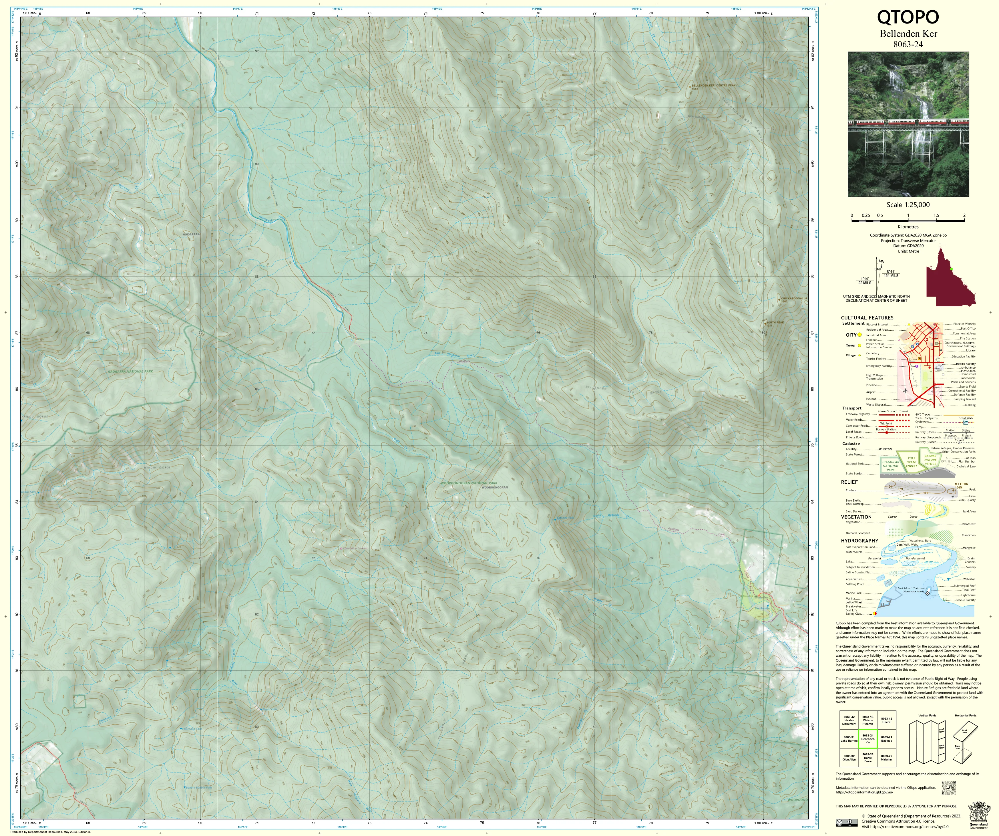
8063-24 Bellenden Ker QTopo 1:25,000 Topographic Map
QTopo 8063-24 — Bellenden Ker
1:25,000 Topographic Map
A high-precision topographic map for navigating the steep, rainforest-clad terrain surrounding Bellenden Ker, one of Far North Queensland’s most dramatic and weather-intensive mountain environments.
The QTopo 8063-24 (Bellenden Ker) sheet—produced by the Queensland Department of Resources—forms part of Queensland’s authoritative 1:25,000 topographic mapping series. Bellenden Ker, the second-highest peak in Queensland and part of the Wet Tropics World Heritage Area, is renowned for its extreme rainfall, dense vegetation, complex drainage systems, and challenging access. This map provides the clarity and detail essential for safe navigation, scientific fieldwork, and effective land management.
Whether you're conducting ecological surveys, planning a demanding ascent, coordinating emergency response, or managing conservation areas, QTopo 8063-24 gives you the accuracy and terrain intelligence needed for work in one of Australia’s most rugged mountain regions.
🗺️ Map Content and Features
At 1:25,000 scale—where 1 cm = 250 m—this sheet delivers detailed, field-ready mapping including:
-
Contour lines at fine intervals showing steep slopes, ridgelines, saddles, and deeply incised rainforest valleys
-
Hydrology features including rivers, creeks, waterfalls, drainage channels, and wet gullies typical of the Wet Tropics
-
Walking tracks, access routes, 4WD trails & service paths, including approaches to summit areas and research facilities
-
Infrastructure such as communications towers, research stations, footbridges, huts, powerlines, and service structures
-
Vegetation mapping showing dense rainforest, high-altitude scrub, woodland patches, and cleared sections
-
Land tenure boundaries: national parks, reserves, freehold parcels, and state-managed land
-
Named topographic features including peaks, knolls, spurs, gullies, and notable natural formations
-
Points of interest relevant to hikers, researchers, land managers, and emergency responders
All QTopo maps are produced using Queensland’s authoritative spatial datasets for accurate and consistent cartography.
🧭 Who Uses This Map?
The Bellenden Ker 8063-24 Topographic Map is an essential tool for:
-
Environmental scientists & ecologists – biodiversity studies, habitat mapping, upland research
-
Emergency services & SES – cyclone/flood scenario planning, remote rescue, and response coordination
-
Bushwalkers & mountaineers – planning demanding ascents and navigating steep terrain
-
National park rangers & land managers – conservation work, track maintenance, and access management
-
Surveyors, engineers & planners – detailed terrain assessment and site investigations
-
Outdoor navigation trainers – teaching advanced rainforest and mountain navigation
A trusted reference for professionals and experienced explorers.
💧 Field-Ready Options for Extreme Wet Tropics Conditions
Select the finish designed for Bellenden Ker’s intense rainfall, humidity, and rugged terrain.
✅ Waterproof & Tearproof Tyvek®
-
Printed on DuPont™ Tyvek®, engineered for extreme durability
-
Fully waterproof, tear-resistant, lightweight, and foldable
-
Ideal for heavy rainfall, creek crossings, sweat exposure, and multi-day fieldwork
-
The top choice for field scientists, rangers, and serious hikers
✅ Laminated Edition
-
Encapsulated in 2 × 80-micron gloss laminate
-
Writeable surface for whiteboard markers—excellent for planning or team briefings
-
Compatible with Map Dots for temporary marking
-
Wipe-clean, durable, and resistant to mud, moisture, and abrasion
📄 Standard Paper Edition
-
Crisp, high-quality print
-
Ideal for planning, teaching, or occasional field reference
📐 Map Details
Title: QTopo 8063-24 — Bellenden Ker
Publisher: Queensland Department of Resources
Series: QTopo 1:25,000
Scale: 1:25,000 (1 cm = 250 m)
Dimensions: Approx. 710 mm × 594 mm
Coverage: Bellenden Ker summit region, rainforest slopes, upland ridges, creeks, and operational access routes
Material Options: Paper, laminated, or waterproof Tyvek®
Origin: Printed in Australia
Edition: Latest available (see listing for publication year)
📥 QTopo Map Index
Need adjoining maps for the broader Bellenden Ker or Wooroonooran area?
➡️ Consult the QTopo index or contact us with nearby sheet numbers—such as 8063-23, 8063-25, or 7963-35—and we’ll identify the correct adjoining sheets instantly.
🛒 Ordering & Options
-
Standard folded paper map – great for planning and reference
-
Tyvek® waterproof edition – best for wet, high-altitude, and high-humidity environments
-
Laminated edition – tough, reusable, and perfect for training or operational planning
-
Flat (unfolded) maps available on request for wall display or workshop use
🎯 Summary
The QTopo 8063-24 — Bellenden Ker Topographic Map provides essential terrain, vegetation, and hydrological detail for safe and effective navigation in one of Queensland's most extreme and biologically rich mountain environments. With accurate 1:25,000 cartography and rugged print options, it is indispensable for researchers, rangers, hikers, and field professionals.
Plan with purpose.
Navigate with confidence.
Explore with clarity.
Choose your preferred finish today and take Bellenden Ker into the field with Queensland’s most trusted topographic mapping.
Original: $14.27
-65%$14.27
$4.99Product Information
Product Information
Shipping & Returns
Shipping & Returns
Description
QTopo 8063-24 — Bellenden Ker
1:25,000 Topographic Map
A high-precision topographic map for navigating the steep, rainforest-clad terrain surrounding Bellenden Ker, one of Far North Queensland’s most dramatic and weather-intensive mountain environments.
The QTopo 8063-24 (Bellenden Ker) sheet—produced by the Queensland Department of Resources—forms part of Queensland’s authoritative 1:25,000 topographic mapping series. Bellenden Ker, the second-highest peak in Queensland and part of the Wet Tropics World Heritage Area, is renowned for its extreme rainfall, dense vegetation, complex drainage systems, and challenging access. This map provides the clarity and detail essential for safe navigation, scientific fieldwork, and effective land management.
Whether you're conducting ecological surveys, planning a demanding ascent, coordinating emergency response, or managing conservation areas, QTopo 8063-24 gives you the accuracy and terrain intelligence needed for work in one of Australia’s most rugged mountain regions.
🗺️ Map Content and Features
At 1:25,000 scale—where 1 cm = 250 m—this sheet delivers detailed, field-ready mapping including:
-
Contour lines at fine intervals showing steep slopes, ridgelines, saddles, and deeply incised rainforest valleys
-
Hydrology features including rivers, creeks, waterfalls, drainage channels, and wet gullies typical of the Wet Tropics
-
Walking tracks, access routes, 4WD trails & service paths, including approaches to summit areas and research facilities
-
Infrastructure such as communications towers, research stations, footbridges, huts, powerlines, and service structures
-
Vegetation mapping showing dense rainforest, high-altitude scrub, woodland patches, and cleared sections
-
Land tenure boundaries: national parks, reserves, freehold parcels, and state-managed land
-
Named topographic features including peaks, knolls, spurs, gullies, and notable natural formations
-
Points of interest relevant to hikers, researchers, land managers, and emergency responders
All QTopo maps are produced using Queensland’s authoritative spatial datasets for accurate and consistent cartography.
🧭 Who Uses This Map?
The Bellenden Ker 8063-24 Topographic Map is an essential tool for:
-
Environmental scientists & ecologists – biodiversity studies, habitat mapping, upland research
-
Emergency services & SES – cyclone/flood scenario planning, remote rescue, and response coordination
-
Bushwalkers & mountaineers – planning demanding ascents and navigating steep terrain
-
National park rangers & land managers – conservation work, track maintenance, and access management
-
Surveyors, engineers & planners – detailed terrain assessment and site investigations
-
Outdoor navigation trainers – teaching advanced rainforest and mountain navigation
A trusted reference for professionals and experienced explorers.
💧 Field-Ready Options for Extreme Wet Tropics Conditions
Select the finish designed for Bellenden Ker’s intense rainfall, humidity, and rugged terrain.
✅ Waterproof & Tearproof Tyvek®
-
Printed on DuPont™ Tyvek®, engineered for extreme durability
-
Fully waterproof, tear-resistant, lightweight, and foldable
-
Ideal for heavy rainfall, creek crossings, sweat exposure, and multi-day fieldwork
-
The top choice for field scientists, rangers, and serious hikers
✅ Laminated Edition
-
Encapsulated in 2 × 80-micron gloss laminate
-
Writeable surface for whiteboard markers—excellent for planning or team briefings
-
Compatible with Map Dots for temporary marking
-
Wipe-clean, durable, and resistant to mud, moisture, and abrasion
📄 Standard Paper Edition
-
Crisp, high-quality print
-
Ideal for planning, teaching, or occasional field reference
📐 Map Details
Title: QTopo 8063-24 — Bellenden Ker
Publisher: Queensland Department of Resources
Series: QTopo 1:25,000
Scale: 1:25,000 (1 cm = 250 m)
Dimensions: Approx. 710 mm × 594 mm
Coverage: Bellenden Ker summit region, rainforest slopes, upland ridges, creeks, and operational access routes
Material Options: Paper, laminated, or waterproof Tyvek®
Origin: Printed in Australia
Edition: Latest available (see listing for publication year)
📥 QTopo Map Index
Need adjoining maps for the broader Bellenden Ker or Wooroonooran area?
➡️ Consult the QTopo index or contact us with nearby sheet numbers—such as 8063-23, 8063-25, or 7963-35—and we’ll identify the correct adjoining sheets instantly.
🛒 Ordering & Options
-
Standard folded paper map – great for planning and reference
-
Tyvek® waterproof edition – best for wet, high-altitude, and high-humidity environments
-
Laminated edition – tough, reusable, and perfect for training or operational planning
-
Flat (unfolded) maps available on request for wall display or workshop use
🎯 Summary
The QTopo 8063-24 — Bellenden Ker Topographic Map provides essential terrain, vegetation, and hydrological detail for safe and effective navigation in one of Queensland's most extreme and biologically rich mountain environments. With accurate 1:25,000 cartography and rugged print options, it is indispensable for researchers, rangers, hikers, and field professionals.
Plan with purpose.
Navigate with confidence.
Explore with clarity.
Choose your preferred finish today and take Bellenden Ker into the field with Queensland’s most trusted topographic mapping.


