QTopo 8063-31 — Lake Barrine
1:25,000 Topographic Map
A high-resolution, field-ready topographic map covering the lush rainforest, volcanic crater lake, and surrounding upland terrain of Lake Barrine in Far North Queensland.
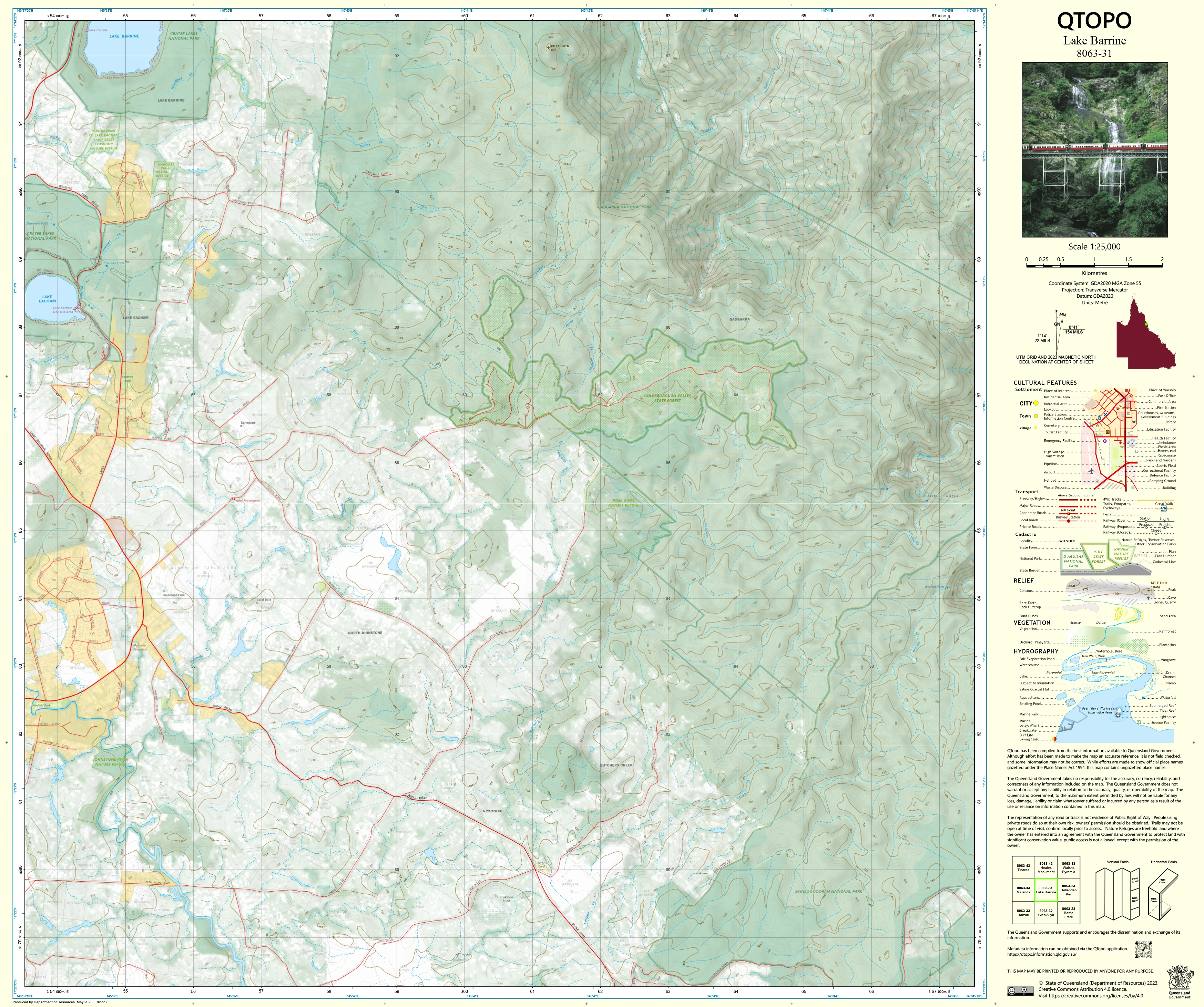
The QTopo 8063-31 (Lake Barrine) sheet—produced by the Queensland Department of Resources—forms part of the state’s official 1:25,000 topographic mapping series. Situated within the Wet Tropics World Heritage Area, Lake Barrine is one of the Atherton Tablelands’ most iconic volcanic crater lakes, surrounded by dense rainforest, steep slopes, rich biodiversity, and a network of walking trails and rural access routes. This map provides the clarity and precision required for safe navigation and professional fieldwork in this complex and ecologically important landscape.
Whether you're conducting environmental surveys, planning walking routes around the lake, managing conservation areas, or coordinating emergency response, QTopo 8063-31 offers the detail and reliability essential for effective terrain analysis and on-ground decision-making.
🗺️ Map Content and Features
Rendered at 1:25,000 scale—where 1 cm = 250 m—this QTopo sheet provides high-detail cartography including:
-
Contour lines showing crater walls, slopes, ridgelines, and the surrounding upland terrain
-
Hydrology features: Lake Barrine itself, creeks, drainage lines, wetlands, and seasonal waterways
-
Walking tracks, access paths, 4WD routes & rural roads, including approaches to day-use areas and surrounding properties
-
Infrastructure such as picnic facilities, buildings, powerlines, footbridges, and research sites
-
Vegetation mapping highlighting dense tropical rainforest, woodland, open terrain, and managed areas
-
Land tenure boundaries: national park zones, reserves, freehold parcels, and state-managed land
-
Named natural features including peaks, knolls, crater formations, creek valleys, and topographic markers
-
Points of interest for ecologists, bushwalkers, rangers, and emergency teams
All QTopo maps draw from authoritative Queensland spatial datasets for consistent accuracy and reliable symbology.
🧭 Who Uses This Map?
The Lake Barrine 8063-31 Topographic Map is widely used by:
-
Environmental scientists & ecologists – crater lake studies, biodiversity surveys, vegetation mapping
-
Bushwalkers & nature photographers – exploring and navigating trails around the lake
-
National park rangers & land managers – access planning, conservation management, and operational work
-
Emergency services & SES – flood planning, remote rescue, and navigation in rainforest terrain
-
Surveyors, planners & infrastructure teams – terrain interpretation and site assessment
-
Outdoor educators & navigation trainers – teaching field navigation in rainforest and volcanic landscapes
A trusted resource for both recreational exploration and professional field operations.
💧 Field-Ready Options for Wet Tropics Conditions
Choose the finish suited to Lake Barrine’s humid, rainy, and densely vegetated environment.
✅ Waterproof & Tearproof Tyvek®
-
Printed on DuPont™ Tyvek®, built for severe outdoor conditions
-
Fully waterproof, tear-resistant, lightweight, and foldable
-
Perfect for rainforest humidity, rainfall, fog, and sustained handling
-
Ideal for multi-day fieldwork or frequent lake-loop navigation
✅ Laminated Edition
-
Fully encapsulated in 2 × 80-micron gloss laminate
-
Writeable surface for whiteboard markers—excellent for planning and briefings
-
Compatible with Map Dots for temporary marking
-
Durable, wipe-clean, and resistant to moisture, mud, and abrasion
📄 Standard Paper Edition
-
Crisp, detailed printing
-
Ideal for planning, study, or occasional field reference
📐 Map Details
Title: QTopo 8063-31 — Lake Barrine
Publisher: Queensland Department of Resources
Series: QTopo 1:25,000
Scale: 1:25,000 (1 cm = 250 m)
Dimensions: Approx. 710 mm × 594 mm
Coverage: Lake Barrine, crater slopes, surrounding rainforest, creeks, rural access routes, and nearby upland terrain
Material Options: Paper, laminated, or waterproof Tyvek®
Printed in: Australia
Edition: Latest available (see product listing for publication year)
📥 QTopo Map Index
Need adjoining sheets covering the Atherton Tablelands or broader Wet Tropics?
➡️ Refer to the QTopo index or contact us with nearby sheet numbers—such as 8063-30, 8063-32, or 7963-42—and we’ll locate the correct neighbouring maps immediately.
🛒 Ordering & Options
-
Standard folded paper map – ideal for planning and classroom use
-
Tyvek® waterproof edition – best for humid rainforest conditions
-
Laminated edition – reusable, durable, and perfect for training or operational planning
-
Flat (unfolded) maps available for wall-mounting or workshop use
🎯 Summary
The QTopo 8063-31 — Lake Barrine Topographic Map provides critical terrain, vegetation, and hydrological detail for navigating one of Far North Queensland’s most beautiful and ecologically significant crater-lake environments. With precise 1:25,000 mapping and rugged print options, it is indispensable for researchers, rangers, hikers, and field professionals.
Plan with purpose.
Navigate with confidence.
Explore with clarity.
Choose your preferred finish today and take Lake Barrine into the field with Queensland’s most trusted topographic mapping.


