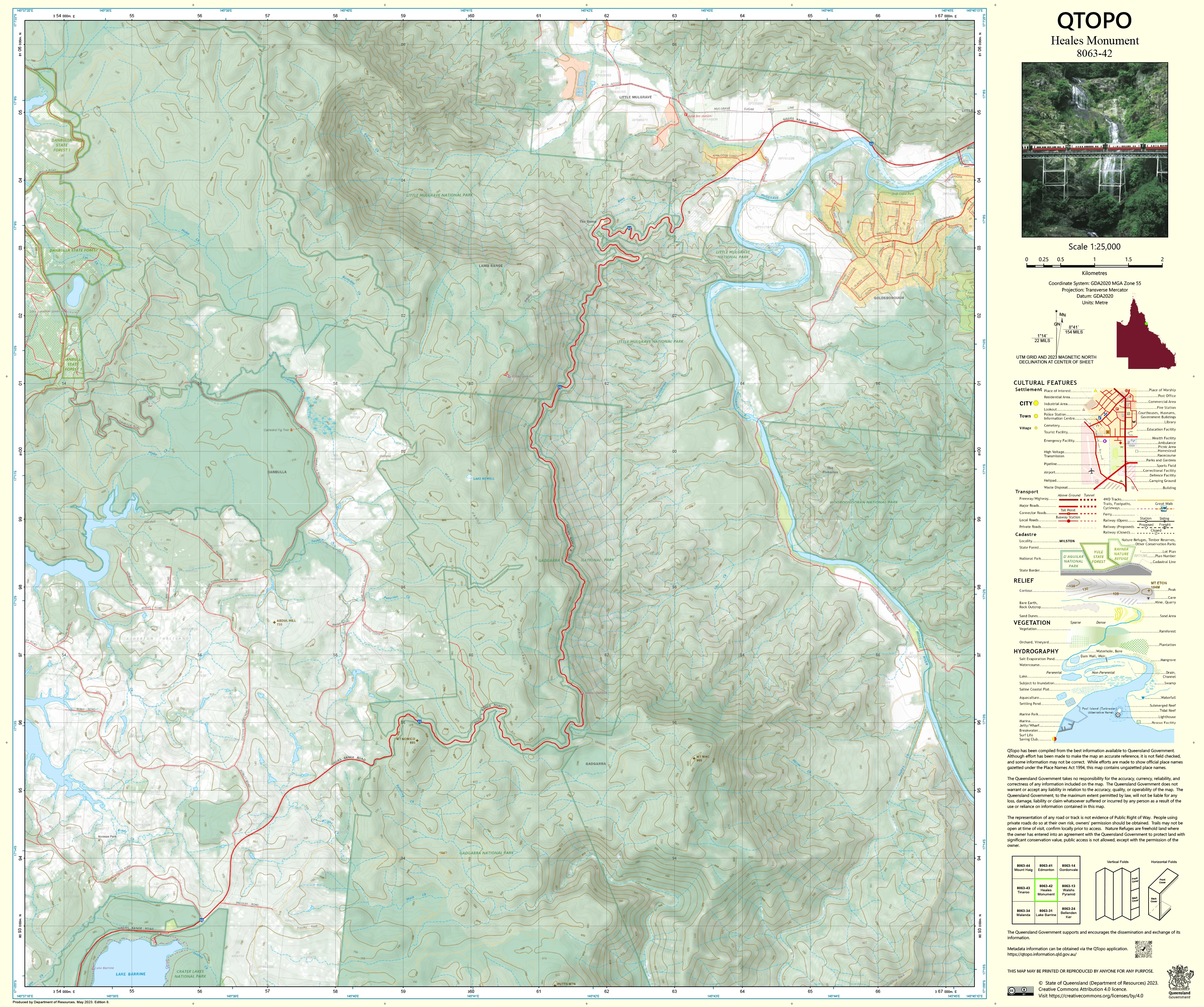
8063-42 Heales Monumnet QTopo 1:25,000 Topographic Map
QTopo 8063-42 — Heales Monument
1:25,000 Topographic Map
A precise and field-ready topographic map covering the rugged uplands, rainforest edges, and rural landscapes surrounding Heales Monument in Far North Queensland.
The QTopo 8063-42 (Heales Monument) sheet—produced by the Queensland Department of Resources—is part of Queensland’s official 1:25,000 topographic mapping series. This region combines steep hills, dense vegetation, creek networks, rural properties, and patches of Wet Tropics rainforest. Whether used for environmental fieldwork, rural operations, navigation training, or emergency response, this map delivers the clarity and accuracy required for confident decision-making in mixed terrain.
QTopo 8063-42 offers clean, modern cartography derived from authoritative state spatial datasets, ensuring dependable detail for professional and recreational users.
🗺️ Map Content and Features
At 1:25,000 scale, where 1 cm = 250 m, this map provides detailed, terrain-focused information including:
-
Contour lines showing slopes, ridgelines, knolls, escarpments, and surrounding upland terrain
-
Hydrology: creeks, drainage lines, wetlands, waterholes, and seasonal flow channels
-
Roads, tracks, 4WD routes & rural access paths, supporting both navigation and operational planning
-
Infrastructure such as buildings, powerlines, communication assets, fencelines, rural yards, and small facilities
-
Vegetation mapping covering rainforest margins, woodland, open farmland, and cleared rural blocks
-
Land tenure boundaries: freehold, leasehold, reserves, national parks, and state-managed parcels
-
Named topographic features including Heales Monument, nearby hills, valleys, and mapped natural landmarks
-
Points of interest relevant to surveyors, field scientists, travellers, and emergency responders
As with all QTopo sheets, the map uses consistent symbology and accurate spatial datasets for reliable on-ground representation.
🧭 Who Uses This Map?
The Heales Monument 8063-42 Topographic Map is relied upon by:
-
Environmental scientists & ecologists – site surveys, habitat studies, and vegetation mapping
-
Rural landholders & land managers – property planning, access management, and boundary awareness
-
Emergency services & SES – flood planning, bushfire coordination, and remote rescue
-
4WD travellers & explorers – navigating rural roads and mixed-terrain routes
-
Surveyors, planners & engineers – terrain and infrastructure assessment
-
Outdoor educators & navigation instructors – realistic terrain analysis and map-reading practice
A trusted tool for both professional and recreational navigation.
💧 Field-Ready Options for Rugged FNQ Conditions
Choose the finish designed for North Queensland’s humidity, rainfall, dust, and rough handling.
✅ Waterproof & Tearproof Tyvek®
-
Printed on DuPont™ Tyvek®, built for extreme durability
-
Completely waterproof, tear-resistant, lightweight, and foldable
-
Performs reliably in humidity, rain, creek crossings, and rugged outdoor use
-
The best choice for heavy fieldwork and remote travel
✅ Laminated Edition
-
Encapsulated in 2 × 80-micron gloss laminate
-
Writeable surface ideal for whiteboard markers
-
Compatible with Map Dots for marking temporary field locations
-
Durable, wipe-clean, and resistant to moisture, abrasion, and dirt
📄 Standard Paper Edition
-
High-resolution printing
-
Suitable for office planning, classroom use, or light fieldwork
📐 Map Details
Title: QTopo 8063-42 — Heales Monument
Publisher: Queensland Department of Resources
Series: QTopo 1:25,000
Scale: 1:25,000 (1 cm = 250 m)
Dimensions: Approx. 710 mm × 594 mm
Coverage: Heales Monument, surrounding hills, creeks, rural properties, and mixed forested terrain
Material Options: Paper, laminated, or waterproof Tyvek®
Printed in: Australia
Edition: Latest available (see product listing for publication year)
📥 QTopo Map Index
Need adjoining coverage?
➡️ Refer to the QTopo index or contact us with nearby sheet numbers—such as 8063-41, 8063-43, or 7963-52—and we’ll locate the correct adjoining maps immediately.
🛒 Ordering & Options
-
Standard folded paper map – ideal for reference and planning
-
Tyvek® waterproof edition – best for rugged, humid, and all-weather fieldwork
-
Laminated edition – reusable, durable, and perfect for operations or training
-
Flat (unfolded) maps available for workshops or wall display
🎯 Summary
The QTopo 8063-42 — Heales Monument Topographic Map provides essential topographic, hydrological, and vegetation detail for navigating and working in this mixed-terrain region of Far North Queensland. With precise 1:25,000 cartography and durable print options, it is indispensable for land managers, researchers, explorers, and field professionals.
Plan with purpose.
Navigate with confidence.
Explore with clarity.
Choose your preferred finish today and take Heales Monument into the field with Queensland’s most trusted topographic mapping.
Original: $14.27
-65%$14.27
$4.99Product Information
Product Information
Shipping & Returns
Shipping & Returns
Description
QTopo 8063-42 — Heales Monument
1:25,000 Topographic Map
A precise and field-ready topographic map covering the rugged uplands, rainforest edges, and rural landscapes surrounding Heales Monument in Far North Queensland.
The QTopo 8063-42 (Heales Monument) sheet—produced by the Queensland Department of Resources—is part of Queensland’s official 1:25,000 topographic mapping series. This region combines steep hills, dense vegetation, creek networks, rural properties, and patches of Wet Tropics rainforest. Whether used for environmental fieldwork, rural operations, navigation training, or emergency response, this map delivers the clarity and accuracy required for confident decision-making in mixed terrain.
QTopo 8063-42 offers clean, modern cartography derived from authoritative state spatial datasets, ensuring dependable detail for professional and recreational users.
🗺️ Map Content and Features
At 1:25,000 scale, where 1 cm = 250 m, this map provides detailed, terrain-focused information including:
-
Contour lines showing slopes, ridgelines, knolls, escarpments, and surrounding upland terrain
-
Hydrology: creeks, drainage lines, wetlands, waterholes, and seasonal flow channels
-
Roads, tracks, 4WD routes & rural access paths, supporting both navigation and operational planning
-
Infrastructure such as buildings, powerlines, communication assets, fencelines, rural yards, and small facilities
-
Vegetation mapping covering rainforest margins, woodland, open farmland, and cleared rural blocks
-
Land tenure boundaries: freehold, leasehold, reserves, national parks, and state-managed parcels
-
Named topographic features including Heales Monument, nearby hills, valleys, and mapped natural landmarks
-
Points of interest relevant to surveyors, field scientists, travellers, and emergency responders
As with all QTopo sheets, the map uses consistent symbology and accurate spatial datasets for reliable on-ground representation.
🧭 Who Uses This Map?
The Heales Monument 8063-42 Topographic Map is relied upon by:
-
Environmental scientists & ecologists – site surveys, habitat studies, and vegetation mapping
-
Rural landholders & land managers – property planning, access management, and boundary awareness
-
Emergency services & SES – flood planning, bushfire coordination, and remote rescue
-
4WD travellers & explorers – navigating rural roads and mixed-terrain routes
-
Surveyors, planners & engineers – terrain and infrastructure assessment
-
Outdoor educators & navigation instructors – realistic terrain analysis and map-reading practice
A trusted tool for both professional and recreational navigation.
💧 Field-Ready Options for Rugged FNQ Conditions
Choose the finish designed for North Queensland’s humidity, rainfall, dust, and rough handling.
✅ Waterproof & Tearproof Tyvek®
-
Printed on DuPont™ Tyvek®, built for extreme durability
-
Completely waterproof, tear-resistant, lightweight, and foldable
-
Performs reliably in humidity, rain, creek crossings, and rugged outdoor use
-
The best choice for heavy fieldwork and remote travel
✅ Laminated Edition
-
Encapsulated in 2 × 80-micron gloss laminate
-
Writeable surface ideal for whiteboard markers
-
Compatible with Map Dots for marking temporary field locations
-
Durable, wipe-clean, and resistant to moisture, abrasion, and dirt
📄 Standard Paper Edition
-
High-resolution printing
-
Suitable for office planning, classroom use, or light fieldwork
📐 Map Details
Title: QTopo 8063-42 — Heales Monument
Publisher: Queensland Department of Resources
Series: QTopo 1:25,000
Scale: 1:25,000 (1 cm = 250 m)
Dimensions: Approx. 710 mm × 594 mm
Coverage: Heales Monument, surrounding hills, creeks, rural properties, and mixed forested terrain
Material Options: Paper, laminated, or waterproof Tyvek®
Printed in: Australia
Edition: Latest available (see product listing for publication year)
📥 QTopo Map Index
Need adjoining coverage?
➡️ Refer to the QTopo index or contact us with nearby sheet numbers—such as 8063-41, 8063-43, or 7963-52—and we’ll locate the correct adjoining maps immediately.
🛒 Ordering & Options
-
Standard folded paper map – ideal for reference and planning
-
Tyvek® waterproof edition – best for rugged, humid, and all-weather fieldwork
-
Laminated edition – reusable, durable, and perfect for operations or training
-
Flat (unfolded) maps available for workshops or wall display
🎯 Summary
The QTopo 8063-42 — Heales Monument Topographic Map provides essential topographic, hydrological, and vegetation detail for navigating and working in this mixed-terrain region of Far North Queensland. With precise 1:25,000 cartography and durable print options, it is indispensable for land managers, researchers, explorers, and field professionals.
Plan with purpose.
Navigate with confidence.
Explore with clarity.
Choose your preferred finish today and take Heales Monument into the field with Queensland’s most trusted topographic mapping.


