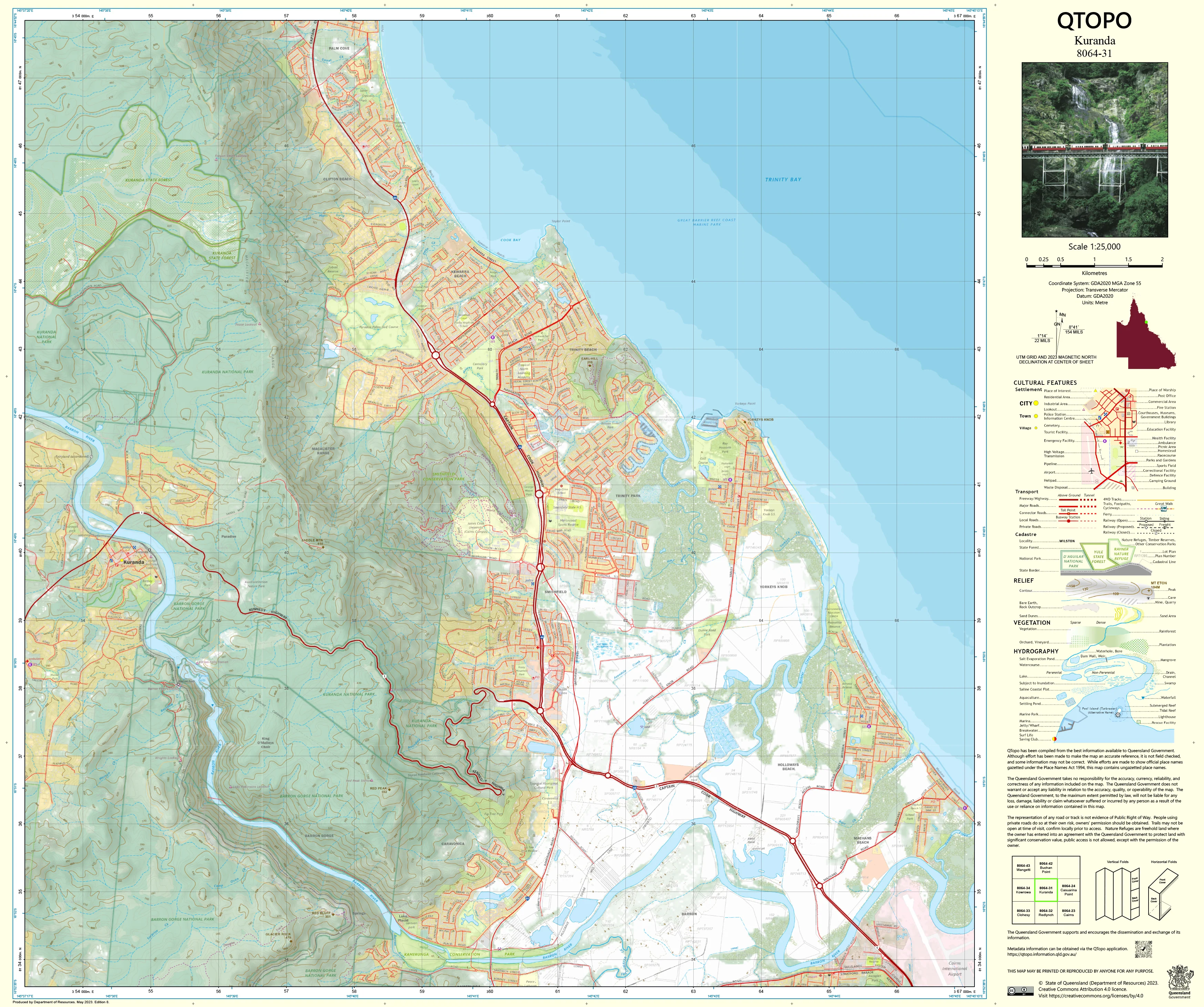
8064-31 Kuranda QTopo 1:25,000 Topographic Map
QTopo 8064-31 — Kuranda
1:25,000 Topographic Map
A high-precision topographic map covering the rainforest plateau, river systems, and escarpment terrain surrounding Kuranda, one of Far North Queensland’s most iconic hinterland townships.
The QTopo 8064-31 (Kuranda) sheet—produced by the Queensland Department of Resources—forms part of the official 1:25,000 QTopo mapping series. Nestled within the Wet Tropics World Heritage Area and bordered by steep valleys, dense rainforest, and the Barron River gorge, Kuranda’s landscape demands accurate and detailed mapping for safe navigation and professional fieldwork.
Whether you're conducting ecological studies, bushwalking, managing rural land, or planning emergency response, QTopo 8064-31 provides the clarity, terrain detail, and high-resolution accuracy essential for effective decision-making in this complex region.
🗺️ Map Content and Features
Rendered at 1:25,000 scale—where 1 cm = 250 m—this sheet provides high-detail mapping ideal for rainforest and escarpment terrain:
-
Contour lines showing steep slopes, escarpments, ridgelines, and plateau edges of the Kuranda region
-
Hydrology including the Barron River, creeks, waterfalls, drainage lines, wetlands, and seasonal waterways
-
Roads, 4WD routes, rural access tracks & walking paths, including key approaches into Kuranda and local trails
-
Infrastructure such as buildings, utilities, powerlines, bridges, tourist facilities, rail lines, and local services
-
Vegetation mapping covering dense tropical rainforest, woodland, open areas, rural blocks, and cleared terrain
-
Land tenure boundaries: national park, reserves, private land, state-managed areas, and conservation zones
-
Named natural features including hills, knolls, gullies, creek valleys, and prominent geographic markers
-
Points of interest relevant to tourism, ecology, navigation, and operational fieldwork
Every QTopo sheet is based on authoritative Queensland spatial datasets for consistent accuracy and dependable cartography.
🧭 Who Uses This Map?
The Kuranda 8064-31 Topographic Map is widely used by:
-
Environmental scientists & ecologists – biodiversity surveys, habitat mapping, rainforest assessments
-
Bushwalkers, hikers & explorers – navigating tracks around Kuranda and nearby rainforest escarpments
-
Rural landholders & land managers – access planning, infrastructure mapping, property boundaries
-
Emergency services & SES – flood modelling, search and rescue, and response coordination
-
Surveyors, planners & infrastructure teams – terrain evaluation and project assessment
-
Tourism operators & outdoor educators – planning routes and teaching real-world navigation skills
It remains one of the most essential map sheets in the northern Wet Tropics.
💧 Field-Ready Options for Wet Tropics Conditions
Choose the finish best suited to Kuranda’s high humidity, heavy rainfall, and rugged access routes.
✅ Waterproof & Tearproof Tyvek®
-
Printed on DuPont™ Tyvek®, built for extreme outdoor use
-
100% waterproof, tear-resistant, lightweight, and foldable
-
Perfect for humid rainforest conditions, wet-season rain, and frequent field handling
-
The best option for researchers, explorers, and multi-day field teams
✅ Laminated Edition
-
Encapsulated in 2 × 80-micron gloss laminate
-
Writeable surface ideal for whiteboard markers
-
Compatible with Map Dots for temporary location marking
-
Wipe-clean, durable, and resistant to moisture, mud, and abrasion
📄 Standard Paper Edition
-
Crisp, detailed printing
-
Ideal for office planning, education, or light field reference
📐 Map Details
Title: QTopo 8064-31 — Kuranda
Publisher: Queensland Department of Resources
Series: QTopo 1:25,000
Scale: 1:25,000 (1 cm = 250 m)
Dimensions: Approx. 710 mm × 594 mm
Coverage: Kuranda township, surrounding rainforest plateau, Barron River gorge, rural holdings, and escarpment terrain
Material Options: Paper, laminated, or waterproof Tyvek®
Origin: Printed in Australia
Edition: Latest available (check listing for year)
📥 QTopo Map Index
Need broader coverage of the Atherton Tablelands, Barron Gorge, or Cairns hinterland?
➡️ Refer to the QTopo index or contact us with adjacent sheet numbers—such as 8064-30, 8064-32, or 7964-41—and we’ll help you find the correct adjoining maps instantly.
🛒 Ordering & Options
-
Standard folded paper map – ideal for planning and reference
-
Tyvek® waterproof edition – best for wet, humid, and rugged outdoor conditions
-
Laminated edition – reusable and durable, suitable for operational or educational use
-
Flat (unfolded) versions available on request for wall-mounting or workshop use
🎯 Summary
The QTopo 8064-31 — Kuranda Topographic Map provides essential terrain, hydrological, and vegetation detail for navigating and working within one of the Wet Tropics’ most visited and environmentally significant regions. With precise 1:25,000 mapping and rugged finish options, it is indispensable for ecologists, hikers, rangers, and field professionals.
Plan with purpose.
Navigate with confidence.
Explore with clarity.
Choose your preferred finish today and take Kuranda into the field with Queensland’s most trusted topographic mapping.
Original: $14.27
-65%$14.27
$4.99Product Information
Product Information
Shipping & Returns
Shipping & Returns
Description
QTopo 8064-31 — Kuranda
1:25,000 Topographic Map
A high-precision topographic map covering the rainforest plateau, river systems, and escarpment terrain surrounding Kuranda, one of Far North Queensland’s most iconic hinterland townships.
The QTopo 8064-31 (Kuranda) sheet—produced by the Queensland Department of Resources—forms part of the official 1:25,000 QTopo mapping series. Nestled within the Wet Tropics World Heritage Area and bordered by steep valleys, dense rainforest, and the Barron River gorge, Kuranda’s landscape demands accurate and detailed mapping for safe navigation and professional fieldwork.
Whether you're conducting ecological studies, bushwalking, managing rural land, or planning emergency response, QTopo 8064-31 provides the clarity, terrain detail, and high-resolution accuracy essential for effective decision-making in this complex region.
🗺️ Map Content and Features
Rendered at 1:25,000 scale—where 1 cm = 250 m—this sheet provides high-detail mapping ideal for rainforest and escarpment terrain:
-
Contour lines showing steep slopes, escarpments, ridgelines, and plateau edges of the Kuranda region
-
Hydrology including the Barron River, creeks, waterfalls, drainage lines, wetlands, and seasonal waterways
-
Roads, 4WD routes, rural access tracks & walking paths, including key approaches into Kuranda and local trails
-
Infrastructure such as buildings, utilities, powerlines, bridges, tourist facilities, rail lines, and local services
-
Vegetation mapping covering dense tropical rainforest, woodland, open areas, rural blocks, and cleared terrain
-
Land tenure boundaries: national park, reserves, private land, state-managed areas, and conservation zones
-
Named natural features including hills, knolls, gullies, creek valleys, and prominent geographic markers
-
Points of interest relevant to tourism, ecology, navigation, and operational fieldwork
Every QTopo sheet is based on authoritative Queensland spatial datasets for consistent accuracy and dependable cartography.
🧭 Who Uses This Map?
The Kuranda 8064-31 Topographic Map is widely used by:
-
Environmental scientists & ecologists – biodiversity surveys, habitat mapping, rainforest assessments
-
Bushwalkers, hikers & explorers – navigating tracks around Kuranda and nearby rainforest escarpments
-
Rural landholders & land managers – access planning, infrastructure mapping, property boundaries
-
Emergency services & SES – flood modelling, search and rescue, and response coordination
-
Surveyors, planners & infrastructure teams – terrain evaluation and project assessment
-
Tourism operators & outdoor educators – planning routes and teaching real-world navigation skills
It remains one of the most essential map sheets in the northern Wet Tropics.
💧 Field-Ready Options for Wet Tropics Conditions
Choose the finish best suited to Kuranda’s high humidity, heavy rainfall, and rugged access routes.
✅ Waterproof & Tearproof Tyvek®
-
Printed on DuPont™ Tyvek®, built for extreme outdoor use
-
100% waterproof, tear-resistant, lightweight, and foldable
-
Perfect for humid rainforest conditions, wet-season rain, and frequent field handling
-
The best option for researchers, explorers, and multi-day field teams
✅ Laminated Edition
-
Encapsulated in 2 × 80-micron gloss laminate
-
Writeable surface ideal for whiteboard markers
-
Compatible with Map Dots for temporary location marking
-
Wipe-clean, durable, and resistant to moisture, mud, and abrasion
📄 Standard Paper Edition
-
Crisp, detailed printing
-
Ideal for office planning, education, or light field reference
📐 Map Details
Title: QTopo 8064-31 — Kuranda
Publisher: Queensland Department of Resources
Series: QTopo 1:25,000
Scale: 1:25,000 (1 cm = 250 m)
Dimensions: Approx. 710 mm × 594 mm
Coverage: Kuranda township, surrounding rainforest plateau, Barron River gorge, rural holdings, and escarpment terrain
Material Options: Paper, laminated, or waterproof Tyvek®
Origin: Printed in Australia
Edition: Latest available (check listing for year)
📥 QTopo Map Index
Need broader coverage of the Atherton Tablelands, Barron Gorge, or Cairns hinterland?
➡️ Refer to the QTopo index or contact us with adjacent sheet numbers—such as 8064-30, 8064-32, or 7964-41—and we’ll help you find the correct adjoining maps instantly.
🛒 Ordering & Options
-
Standard folded paper map – ideal for planning and reference
-
Tyvek® waterproof edition – best for wet, humid, and rugged outdoor conditions
-
Laminated edition – reusable and durable, suitable for operational or educational use
-
Flat (unfolded) versions available on request for wall-mounting or workshop use
🎯 Summary
The QTopo 8064-31 — Kuranda Topographic Map provides essential terrain, hydrological, and vegetation detail for navigating and working within one of the Wet Tropics’ most visited and environmentally significant regions. With precise 1:25,000 mapping and rugged finish options, it is indispensable for ecologists, hikers, rangers, and field professionals.
Plan with purpose.
Navigate with confidence.
Explore with clarity.
Choose your preferred finish today and take Kuranda into the field with Queensland’s most trusted topographic mapping.


