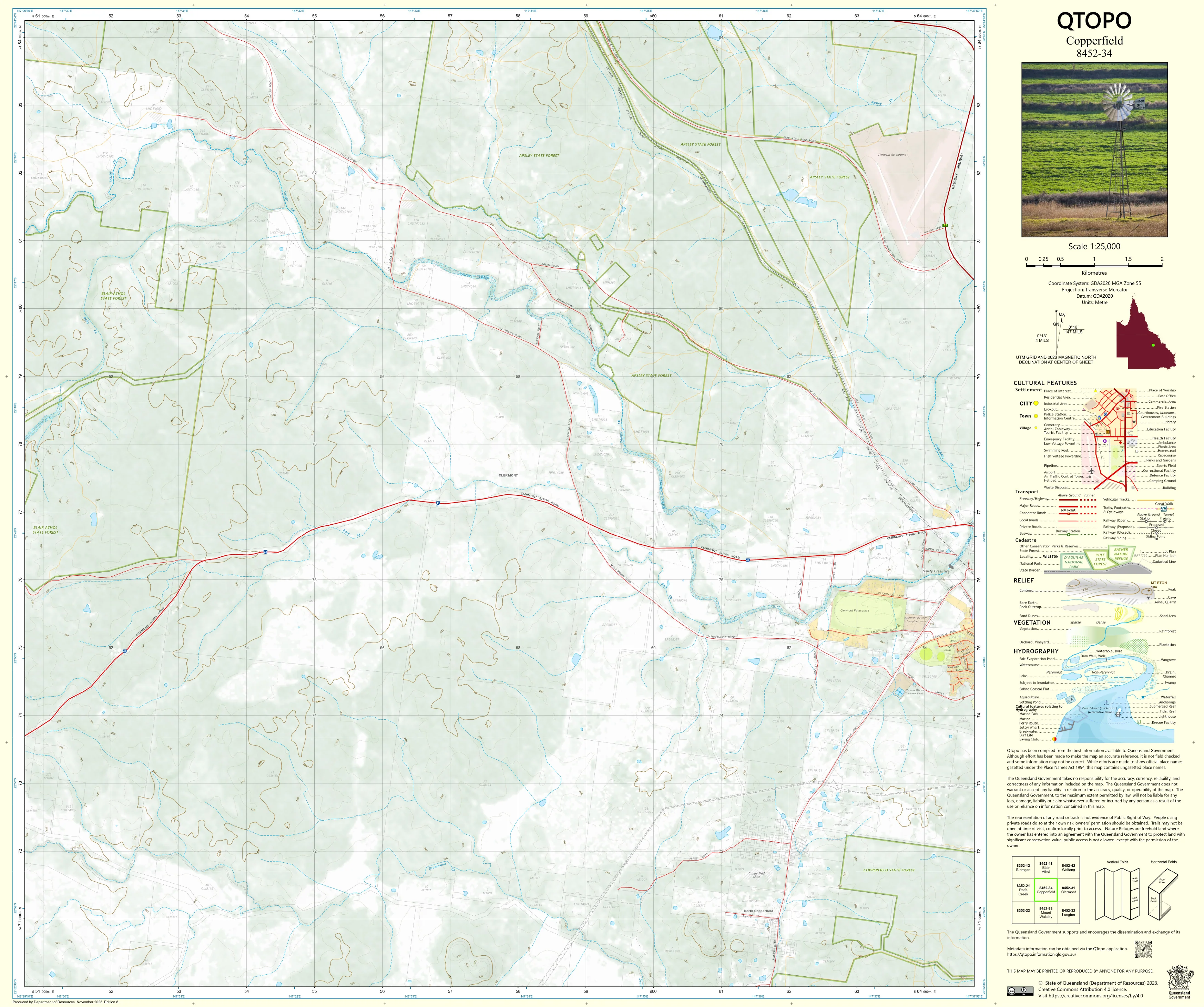
8452-34 Copperfield QTopo 1:25,000 Topographic Map
QTopo 8452-34 — Copperfield
1:25,000 Topographic Map
A high-precision, field-ready topographic map covering the historic Copperfield region—an area shaped by mining heritage, rugged hills, creek systems, and rural landscapes in Central Queensland.
The QTopo 8452-34 (Copperfield) sheet—produced by the Queensland Department of Resources—forms part of the state’s authoritative 1:25,000 topographic mapping series. This map captures a diverse mix of landforms: historic mine sites, open woodland, ridgelines, grazing country, creek networks, and regional access routes. Its accuracy makes it essential for land managers, environmental fieldworkers, resource-sector staff, and anyone navigating or working in Central Queensland’s interior.
Whether you're conducting geological surveys, assessing rural land, exploring historic sites, or supporting emergency operations, QTopo 8452-34 provides the clarity and detail required for safe and efficient navigation.
🗺️ Map Content and Features
Rendered at 1:25,000 scale—where 1 cm = 250 m—this map delivers high-resolution topographic information, including:
-
Contour lines showing hills, ridges, slopes, knolls, escarpments, and broad open terrain
-
Hydrology features: creeks, waterholes, drainage lines, dams, and seasonal flow channels
-
Roads, rural access tracks, 4WD routes & service corridors, vital for property access and fieldwork
-
Infrastructure including homesteads, sheds, fencelines, communication sites, powerlines, and remnants of mining activity
-
Vegetation mapping detailing woodland, scrubland, open country, and cleared rural areas
-
Land tenure boundaries: freehold parcels, leasehold country, reserves, and state-managed land
-
Named natural features such as hills, gullies, flats, creek valleys, and other prominent terrain markers
-
Points of interest relevant to agriculture, geology, heritage exploration, and land assessment
All QTopo maps are generated from Queensland’s authoritative spatial datasets for consistent and dependable accuracy.
🧭 Who Uses This Map?
The Copperfield 8452-34 Topographic Map is widely used by:
-
Resource-sector workers & geologists – exploring mineral areas, mapping landforms, locating historical workings
-
Rural landholders & graziers – property planning, boundary awareness, and water management
-
Environmental scientists & ecologists – field surveys, habitat mapping, and vegetation studies
-
Emergency services & SES – bushfire planning, flood mapping, and regional search & rescue
-
4WD travellers & heritage explorers – navigating tracks, mine sites, and remote terrain
-
Surveyors & planners – terrain analysis and land development evaluation
A trusted reference across both professional and recreational uses.
💧 Field-Ready Options for Central Queensland Conditions
Choose the finish that matches Copperfield’s hot climate, dust, storms, and rugged rural environment.
✅ Waterproof & Tearproof Tyvek®
-
Printed on DuPont™ Tyvek®, engineered for extreme durability
-
Fully waterproof, tear-resistant, lightweight, and foldable
-
Performs reliably in rain, dust, heat, and demanding fieldwork
-
The preferred option for surveyors, rangers, and resource-sector crews
✅ Laminated Edition
-
Encapsulated in 2 × 80-micron gloss laminate
-
Writeable surface ideal for whiteboard markers—great for planning and briefings
-
Wipe-clean, long-lasting, and highly resistant to moisture and abrasion
📄 Standard Paper Edition
-
Crisp, detailed printing
-
Suitable for planning, office reference, or light fieldwork
📐 Map Details
Title: QTopo 8452-34 — Copperfield
Publisher: Queensland Department of Resources
Series: QTopo 1:25,000
Scale: 1:25,000 (1 cm = 250 m)
Dimensions: Approx. 710 mm × 594 mm
Coverage: Copperfield area including historic mining sites, hills, rural properties, creek systems, and access routes
Material Options: Paper, laminated, or waterproof Tyvek®
Printed in: Australia
Edition: Latest available (see product listing for publication year)
📥 QTopo Map Index
Need adjoining coverage of nearby mining districts or grazing lands?
➡️ Consult the QTopo index or contact us with adjacent sheet numbers—such as 8452-33, 8452-35, or 8352-44—and we’ll locate the correct maps instantly.
🛒 Ordering & Options
-
Standard folded paper map – ideal for planning and reference
-
Tyvek® waterproof edition – best for rugged, all-weather fieldwork
-
Laminated edition – reusable and perfect for training or operational planning
-
Flat (unfolded) maps available for workshop or wall display
🎯 Summary
The QTopo 8452-34 — Copperfield Topographic Map provides essential terrain, hydrological, and land-use detail for navigating and managing one of Central Queensland’s historically rich and geographically varied regions. With precise 1:25,000 cartography and durable print options, it is indispensable for geologists, rangers, land managers, and field professionals.
Plan with purpose.
Navigate with confidence.
Explore with clarity.
Choose your preferred finish today and take Copperfield into the field with Queensland’s most trusted topographic mapping.
Product Information
Product Information
Shipping & Returns
Shipping & Returns
Description
QTopo 8452-34 — Copperfield
1:25,000 Topographic Map
A high-precision, field-ready topographic map covering the historic Copperfield region—an area shaped by mining heritage, rugged hills, creek systems, and rural landscapes in Central Queensland.
The QTopo 8452-34 (Copperfield) sheet—produced by the Queensland Department of Resources—forms part of the state’s authoritative 1:25,000 topographic mapping series. This map captures a diverse mix of landforms: historic mine sites, open woodland, ridgelines, grazing country, creek networks, and regional access routes. Its accuracy makes it essential for land managers, environmental fieldworkers, resource-sector staff, and anyone navigating or working in Central Queensland’s interior.
Whether you're conducting geological surveys, assessing rural land, exploring historic sites, or supporting emergency operations, QTopo 8452-34 provides the clarity and detail required for safe and efficient navigation.
🗺️ Map Content and Features
Rendered at 1:25,000 scale—where 1 cm = 250 m—this map delivers high-resolution topographic information, including:
-
Contour lines showing hills, ridges, slopes, knolls, escarpments, and broad open terrain
-
Hydrology features: creeks, waterholes, drainage lines, dams, and seasonal flow channels
-
Roads, rural access tracks, 4WD routes & service corridors, vital for property access and fieldwork
-
Infrastructure including homesteads, sheds, fencelines, communication sites, powerlines, and remnants of mining activity
-
Vegetation mapping detailing woodland, scrubland, open country, and cleared rural areas
-
Land tenure boundaries: freehold parcels, leasehold country, reserves, and state-managed land
-
Named natural features such as hills, gullies, flats, creek valleys, and other prominent terrain markers
-
Points of interest relevant to agriculture, geology, heritage exploration, and land assessment
All QTopo maps are generated from Queensland’s authoritative spatial datasets for consistent and dependable accuracy.
🧭 Who Uses This Map?
The Copperfield 8452-34 Topographic Map is widely used by:
-
Resource-sector workers & geologists – exploring mineral areas, mapping landforms, locating historical workings
-
Rural landholders & graziers – property planning, boundary awareness, and water management
-
Environmental scientists & ecologists – field surveys, habitat mapping, and vegetation studies
-
Emergency services & SES – bushfire planning, flood mapping, and regional search & rescue
-
4WD travellers & heritage explorers – navigating tracks, mine sites, and remote terrain
-
Surveyors & planners – terrain analysis and land development evaluation
A trusted reference across both professional and recreational uses.
💧 Field-Ready Options for Central Queensland Conditions
Choose the finish that matches Copperfield’s hot climate, dust, storms, and rugged rural environment.
✅ Waterproof & Tearproof Tyvek®
-
Printed on DuPont™ Tyvek®, engineered for extreme durability
-
Fully waterproof, tear-resistant, lightweight, and foldable
-
Performs reliably in rain, dust, heat, and demanding fieldwork
-
The preferred option for surveyors, rangers, and resource-sector crews
✅ Laminated Edition
-
Encapsulated in 2 × 80-micron gloss laminate
-
Writeable surface ideal for whiteboard markers—great for planning and briefings
-
Wipe-clean, long-lasting, and highly resistant to moisture and abrasion
📄 Standard Paper Edition
-
Crisp, detailed printing
-
Suitable for planning, office reference, or light fieldwork
📐 Map Details
Title: QTopo 8452-34 — Copperfield
Publisher: Queensland Department of Resources
Series: QTopo 1:25,000
Scale: 1:25,000 (1 cm = 250 m)
Dimensions: Approx. 710 mm × 594 mm
Coverage: Copperfield area including historic mining sites, hills, rural properties, creek systems, and access routes
Material Options: Paper, laminated, or waterproof Tyvek®
Printed in: Australia
Edition: Latest available (see product listing for publication year)
📥 QTopo Map Index
Need adjoining coverage of nearby mining districts or grazing lands?
➡️ Consult the QTopo index or contact us with adjacent sheet numbers—such as 8452-33, 8452-35, or 8352-44—and we’ll locate the correct maps instantly.
🛒 Ordering & Options
-
Standard folded paper map – ideal for planning and reference
-
Tyvek® waterproof edition – best for rugged, all-weather fieldwork
-
Laminated edition – reusable and perfect for training or operational planning
-
Flat (unfolded) maps available for workshop or wall display
🎯 Summary
The QTopo 8452-34 — Copperfield Topographic Map provides essential terrain, hydrological, and land-use detail for navigating and managing one of Central Queensland’s historically rich and geographically varied regions. With precise 1:25,000 cartography and durable print options, it is indispensable for geologists, rangers, land managers, and field professionals.
Plan with purpose.
Navigate with confidence.
Explore with clarity.
Choose your preferred finish today and take Copperfield into the field with Queensland’s most trusted topographic mapping.


