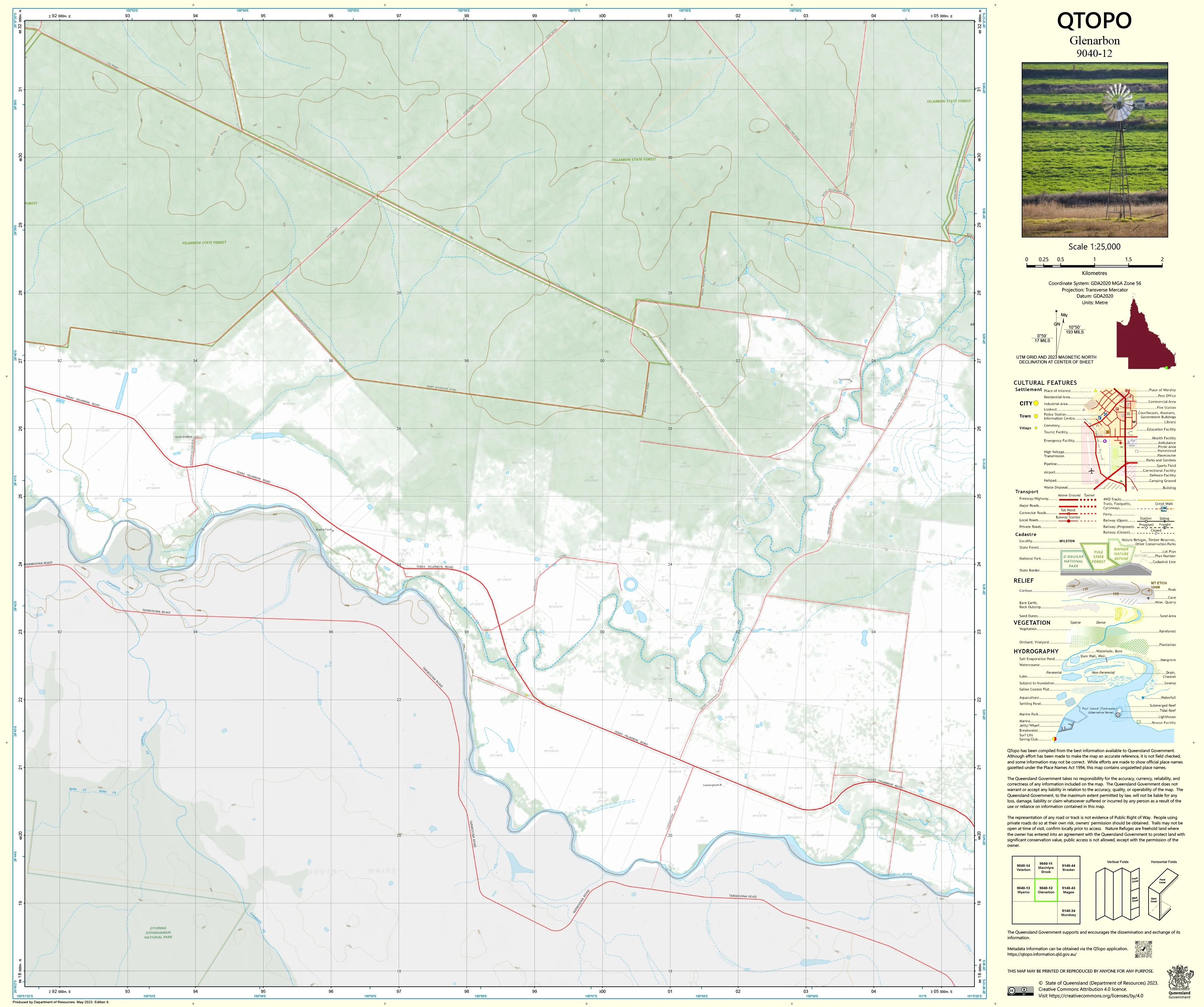
9040-12 Glenarbon QTopo 1:25,000 Topographic Map
QTopo 9040-12 — Glenarbon
1:25,000 Topographic Map
A high-precision, field-ready topographic map covering the Glenarbon region—an area defined by broad agricultural landscapes, timbered country, gently undulating terrain, and interconnected creek systems near the Queensland–New South Wales border.
The QTopo 9040-12 (Glenarbon) sheet—produced by the Queensland Department of Resources—forms part of the state’s authoritative 1:25,000 mapping series. With detailed hydrology, terrain modelling, and rural infrastructure clearly represented, this map is essential for graziers, surveyors, environmental scientists, and emergency responders working in the region.
Whether you're managing rural land, conducting ecological surveys, planning access routes, or navigating backcountry roads, QTopo 9040-12 delivers the accuracy and clarity required for confident decision-making.
🗺️ Map Content and Features
At 1:25,000 scale—where 1 cm = 250 m—this map includes:
-
Contour lines showing gentle slopes, rises, ridgelines, and subtle terrain variations
-
Hydrology features: creeks, drainage lines, farm dams, waterholes, and seasonal channels
-
Roads, farm tracks & 4WD routes linking rural properties and connecting to wider road networks
-
Infrastructure such as homesteads, fencelines, sheds, powerlines, and communication sites
-
Vegetation mapping identifying woodland, scrub, pasture, farmland, and cleared rural areas
-
Land tenure boundaries: freehold parcels, leasehold country, reserves, and state-managed land
-
Named natural features including hills, creeks, valleys, and local terrain markers
-
Points of interest valuable to landholders, ecologists, surveyors, and emergency services
All QTopo mapping uses Queensland’s authoritative spatial datasets for dependable accuracy.
🧭 Who Uses This Map?
The Glenarbon 9040-12 Topographic Map is widely used by:
-
Graziers & agricultural operators – paddock layout, water planning, land management
-
Environmental scientists & ecologists – flora and fauna surveys, habitat assessments
-
Surveyors & planners – terrain analysis, boundary work, and infrastructure planning
-
Emergency services & SES – flood modelling, fire planning, and rural search & rescue
-
4WD travellers & rural explorers – safe navigation through remote farm and bush tracks
-
Outdoor educators – teaching topographic interpretation and navigation skills
A trusted reference across agricultural, environmental, and operational fields.
💧 Field-Ready Options for Rural & All-Weather Conditions
Choose the finish suited to Glenarbon’s warm climate, storm-prone seasons, and rugged rural environments.
✅ Waterproof & Tearproof Tyvek®
-
Printed on DuPont™ Tyvek®
-
Fully waterproof, tear-resistant, lightweight, and foldable
-
Ideal for on-farm work, creek crossings, and repeated field handling
✅ Laminated Edition
-
Encapsulated in 2 × 80-micron gloss laminate
-
Writeable surface for whiteboard markers
-
Wipe-clean and resistant to moisture, dust, mud, and abrasion
📄 Standard Paper Edition
-
Crisp, high-resolution printing
-
Valuable for planning, office reference, or occasional field use
📐 Map Details
Title: QTopo 9040-12 — Glenarbon
Publisher: Queensland Department of Resources
Series: QTopo 1:25,000
Scale: 1:25,000 (1 cm = 250 m)
Dimensions: 710 mm (width) × 594 mm (height)
Coverage: Glenarbon region including farmland, creek systems, timbered country, rural infrastructure, and undulating terrain
Material Options: Paper, laminated, or waterproof Tyvek®
Printed in: Australia
Edition: Latest available (see product listing for publication year)
📥 QTopo Map Index
Need adjoining border-region coverage?
➡️ Provide nearby sheet numbers—such as 9040-11, 9040-13, or 9140-02—and I’ll identify the correct adjoining maps instantly.
🛒 Ordering & Options
-
Standard folded paper map – ideal for planning and farm reference
-
Tyvek® waterproof edition – best for rugged, wet, and all-weather fieldwork
-
Laminated edition – durable and reusable for operational planning and coordination
-
Flat (unfolded) maps available for wall display
🎯 Summary
The QTopo 9040-12 — Glenarbon Topographic Map provides essential terrain, hydrological, and land-use detail for navigating and managing one of the Queensland–NSW border region’s key agricultural landscapes. With precise 1:25,000 mapping and robust print formats, it is indispensable for graziers, surveyors, ecologists, emergency services, and rural explorers.
Plan with purpose.
Navigate with confidence.
Explore with clarity.
Choose your preferred finish today and take Glenarbon into the field with Queensland’s most trusted topographic mapping.
Original: $14.27
-65%$14.27
$4.99Product Information
Product Information
Shipping & Returns
Shipping & Returns
Description
QTopo 9040-12 — Glenarbon
1:25,000 Topographic Map
A high-precision, field-ready topographic map covering the Glenarbon region—an area defined by broad agricultural landscapes, timbered country, gently undulating terrain, and interconnected creek systems near the Queensland–New South Wales border.
The QTopo 9040-12 (Glenarbon) sheet—produced by the Queensland Department of Resources—forms part of the state’s authoritative 1:25,000 mapping series. With detailed hydrology, terrain modelling, and rural infrastructure clearly represented, this map is essential for graziers, surveyors, environmental scientists, and emergency responders working in the region.
Whether you're managing rural land, conducting ecological surveys, planning access routes, or navigating backcountry roads, QTopo 9040-12 delivers the accuracy and clarity required for confident decision-making.
🗺️ Map Content and Features
At 1:25,000 scale—where 1 cm = 250 m—this map includes:
-
Contour lines showing gentle slopes, rises, ridgelines, and subtle terrain variations
-
Hydrology features: creeks, drainage lines, farm dams, waterholes, and seasonal channels
-
Roads, farm tracks & 4WD routes linking rural properties and connecting to wider road networks
-
Infrastructure such as homesteads, fencelines, sheds, powerlines, and communication sites
-
Vegetation mapping identifying woodland, scrub, pasture, farmland, and cleared rural areas
-
Land tenure boundaries: freehold parcels, leasehold country, reserves, and state-managed land
-
Named natural features including hills, creeks, valleys, and local terrain markers
-
Points of interest valuable to landholders, ecologists, surveyors, and emergency services
All QTopo mapping uses Queensland’s authoritative spatial datasets for dependable accuracy.
🧭 Who Uses This Map?
The Glenarbon 9040-12 Topographic Map is widely used by:
-
Graziers & agricultural operators – paddock layout, water planning, land management
-
Environmental scientists & ecologists – flora and fauna surveys, habitat assessments
-
Surveyors & planners – terrain analysis, boundary work, and infrastructure planning
-
Emergency services & SES – flood modelling, fire planning, and rural search & rescue
-
4WD travellers & rural explorers – safe navigation through remote farm and bush tracks
-
Outdoor educators – teaching topographic interpretation and navigation skills
A trusted reference across agricultural, environmental, and operational fields.
💧 Field-Ready Options for Rural & All-Weather Conditions
Choose the finish suited to Glenarbon’s warm climate, storm-prone seasons, and rugged rural environments.
✅ Waterproof & Tearproof Tyvek®
-
Printed on DuPont™ Tyvek®
-
Fully waterproof, tear-resistant, lightweight, and foldable
-
Ideal for on-farm work, creek crossings, and repeated field handling
✅ Laminated Edition
-
Encapsulated in 2 × 80-micron gloss laminate
-
Writeable surface for whiteboard markers
-
Wipe-clean and resistant to moisture, dust, mud, and abrasion
📄 Standard Paper Edition
-
Crisp, high-resolution printing
-
Valuable for planning, office reference, or occasional field use
📐 Map Details
Title: QTopo 9040-12 — Glenarbon
Publisher: Queensland Department of Resources
Series: QTopo 1:25,000
Scale: 1:25,000 (1 cm = 250 m)
Dimensions: 710 mm (width) × 594 mm (height)
Coverage: Glenarbon region including farmland, creek systems, timbered country, rural infrastructure, and undulating terrain
Material Options: Paper, laminated, or waterproof Tyvek®
Printed in: Australia
Edition: Latest available (see product listing for publication year)
📥 QTopo Map Index
Need adjoining border-region coverage?
➡️ Provide nearby sheet numbers—such as 9040-11, 9040-13, or 9140-02—and I’ll identify the correct adjoining maps instantly.
🛒 Ordering & Options
-
Standard folded paper map – ideal for planning and farm reference
-
Tyvek® waterproof edition – best for rugged, wet, and all-weather fieldwork
-
Laminated edition – durable and reusable for operational planning and coordination
-
Flat (unfolded) maps available for wall display
🎯 Summary
The QTopo 9040-12 — Glenarbon Topographic Map provides essential terrain, hydrological, and land-use detail for navigating and managing one of the Queensland–NSW border region’s key agricultural landscapes. With precise 1:25,000 mapping and robust print formats, it is indispensable for graziers, surveyors, ecologists, emergency services, and rural explorers.
Plan with purpose.
Navigate with confidence.
Explore with clarity.
Choose your preferred finish today and take Glenarbon into the field with Queensland’s most trusted topographic mapping.


