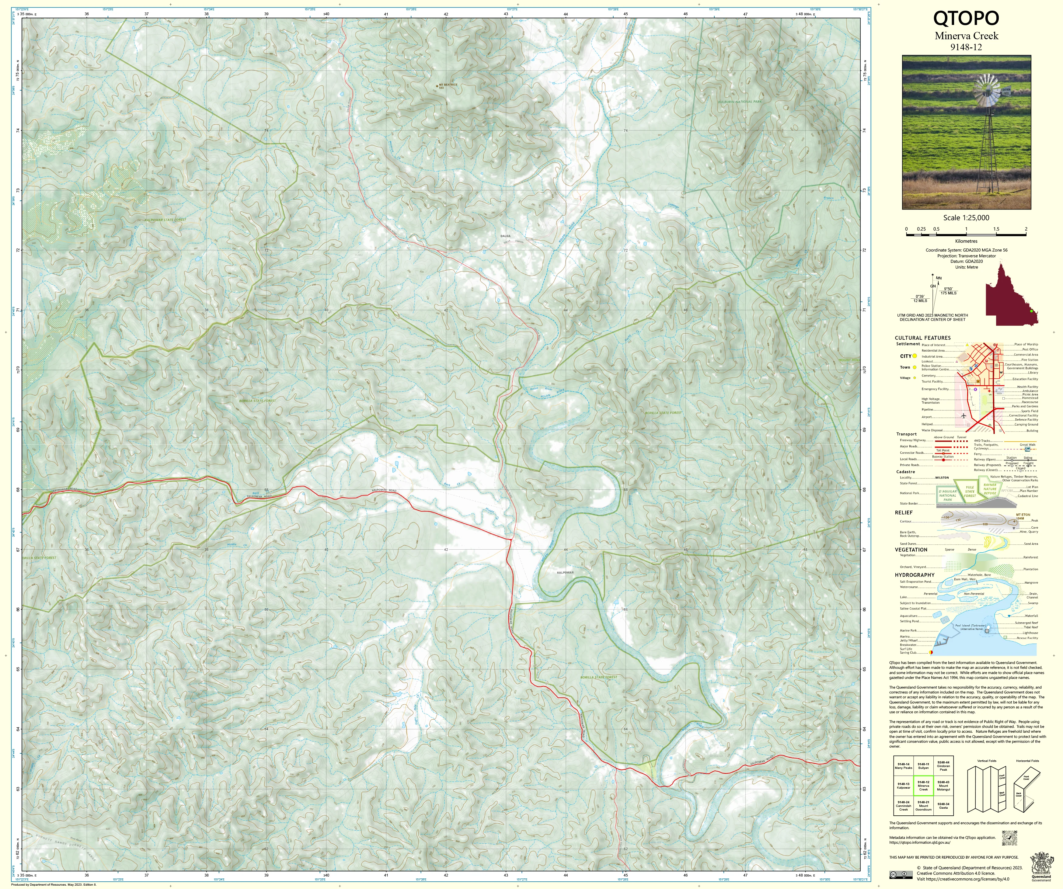
9148-12 Minerva Creek QTopo 1:25,000 Topographic Map
QTopo 9148-12 — Minerva Creek
1:25,000 Topographic Map
A high-precision, field-ready topographic map covering the Minerva Creek region—an area characterised by rugged ridgelines, winding creek systems, forested foothills, rural properties, and access tracks typical of central Queensland’s diverse inland terrain.
The QTopo 9148-12 (Minerva Creek) sheet—produced by the Queensland Department of Resources—forms part of the state’s authoritative 1:25,000 mapping series. Providing detailed terrain modelling, hydrology, vegetation, and infrastructure information, this map is essential for surveyors, environmental scientists, land managers, emergency services, and 4WD explorers working across the district.
Whether you’re conducting ecological surveys, navigating forestry roads, assessing rural boundaries, or planning land management operations, QTopo 9148-12 delivers accuracy and clarity for confident, safe decision-making.
🗺️ Map Content and Features
At 1:25,000 scale—where 1 cm = 250 m—this map contains:
-
Contour lines showing ridges, steep slopes, hilltops, valley floors, and landform transitions
-
Hydrology features: Minerva Creek, tributaries, waterholes, seasonal channels, and drainage networks
-
Roads, forestry tracks & 4WD access routes providing connectivity across rugged country
-
Infrastructure including rural buildings, fencelines, powerlines, communication points, dams, and utilities
-
Vegetation mapping showing woodland, scrub, forest, cleared land, and pastoral areas
-
Land tenure boundaries: freehold, leasehold, state forest, reserves, and managed public land
-
Named natural features such as hills, knolls, gullies, creek corridors, and local terrain markers
-
Points of interest for surveyors, ecologists, landholders, and emergency responders
All QTopo maps are built on Queensland’s authoritative spatial datasets, ensuring consistent and reliable accuracy.
🧭 Who Uses This Map?
The Minerva Creek 9148-12 Topographic Map is widely used by:
-
Environmental scientists & ecologists – flora/fauna surveys, habitat mapping, field research
-
Surveyors & planners – site evaluation, terrain modelling, boundary and infrastructure assessment
-
Rural landholders & graziers – paddock planning, water management, property access
-
Forestry workers & land managers – operational planning and track navigation
-
Emergency services & SES – flood mapping, bushfire response, and rural search & rescue
-
4WD travellers & remote explorers – navigating rugged backcountry tracks
-
Outdoor educators – teaching topographic map-reading and geographic interpretation
A dependable reference for both professional and recreational field operations.
💧 Field-Ready Options for Rugged & Variable Conditions
Choose a finish suitable for Minerva Creek’s warm climate, storm-affected seasons, and rough terrain.
✅ Waterproof & Tearproof Tyvek®
-
Printed on DuPont™ Tyvek®
-
Fully waterproof, tear-resistant, lightweight, and long-lasting
-
Ideal for repeated handling, wet conditions, and remote work
✅ Laminated Edition
-
Encapsulated in 2 × 80-micron gloss laminate
-
Writeable surface for whiteboard markers
-
Wipe-clean and resistant to dust, moisture, mud, and abrasion
📄 Standard Paper Edition
-
Crisp, high-resolution printing
-
Perfect for planning, office use, and general reference
📐 Map Details
Title: QTopo 9148-12 — Minerva Creek
Publisher: Queensland Department of Resources
Series: QTopo 1:25,000
Scale: 1:25,000 (1 cm = 250 m)
Dimensions: 710 mm (width) × 594 mm (height)
Coverage: Minerva Creek, surrounding hills, ridgelines, creek systems, rural properties, and forested country
Material Options: Paper, laminated, or waterproof Tyvek®
Printed in: Australia
Edition: Latest available (see listing for publication year)
📥 QTopo Map Index
Need adjoining or upstream/downstream coverage?
➡️ Provide neighbouring sheet numbers—such as 9148-11, 9148-13, or 9248-02—and we’ll locate the correct adjoining maps immediately.
🛒 Ordering & Options
-
Standard folded paper map – great for planning and reference
-
Tyvek® waterproof edition – best for rugged, all-weather fieldwork
-
Laminated edition – durable, reusable, and ideal for operational planning
-
Flat (unfolded) maps available for wall display or workshop use
🎯 Summary
The QTopo 9148-12 — Minerva Creek Topographic Map provides essential detail on terrain, hydrology, vegetation, and land use across one of central Queensland’s most varied inland environments. With precise 1:25,000 mapping and durable print formats, it is indispensable for ecologists, surveyors, graziers, emergency services, and remote explorers.
Plan with purpose.
Navigate with confidence.
Explore with clarity.
Choose your preferred finish today and take Minerva Creek into the field with Queensland’s most trusted topographic mapping.
Original: $14.27
-65%$14.27
$4.99Product Information
Product Information
Shipping & Returns
Shipping & Returns
Description
QTopo 9148-12 — Minerva Creek
1:25,000 Topographic Map
A high-precision, field-ready topographic map covering the Minerva Creek region—an area characterised by rugged ridgelines, winding creek systems, forested foothills, rural properties, and access tracks typical of central Queensland’s diverse inland terrain.
The QTopo 9148-12 (Minerva Creek) sheet—produced by the Queensland Department of Resources—forms part of the state’s authoritative 1:25,000 mapping series. Providing detailed terrain modelling, hydrology, vegetation, and infrastructure information, this map is essential for surveyors, environmental scientists, land managers, emergency services, and 4WD explorers working across the district.
Whether you’re conducting ecological surveys, navigating forestry roads, assessing rural boundaries, or planning land management operations, QTopo 9148-12 delivers accuracy and clarity for confident, safe decision-making.
🗺️ Map Content and Features
At 1:25,000 scale—where 1 cm = 250 m—this map contains:
-
Contour lines showing ridges, steep slopes, hilltops, valley floors, and landform transitions
-
Hydrology features: Minerva Creek, tributaries, waterholes, seasonal channels, and drainage networks
-
Roads, forestry tracks & 4WD access routes providing connectivity across rugged country
-
Infrastructure including rural buildings, fencelines, powerlines, communication points, dams, and utilities
-
Vegetation mapping showing woodland, scrub, forest, cleared land, and pastoral areas
-
Land tenure boundaries: freehold, leasehold, state forest, reserves, and managed public land
-
Named natural features such as hills, knolls, gullies, creek corridors, and local terrain markers
-
Points of interest for surveyors, ecologists, landholders, and emergency responders
All QTopo maps are built on Queensland’s authoritative spatial datasets, ensuring consistent and reliable accuracy.
🧭 Who Uses This Map?
The Minerva Creek 9148-12 Topographic Map is widely used by:
-
Environmental scientists & ecologists – flora/fauna surveys, habitat mapping, field research
-
Surveyors & planners – site evaluation, terrain modelling, boundary and infrastructure assessment
-
Rural landholders & graziers – paddock planning, water management, property access
-
Forestry workers & land managers – operational planning and track navigation
-
Emergency services & SES – flood mapping, bushfire response, and rural search & rescue
-
4WD travellers & remote explorers – navigating rugged backcountry tracks
-
Outdoor educators – teaching topographic map-reading and geographic interpretation
A dependable reference for both professional and recreational field operations.
💧 Field-Ready Options for Rugged & Variable Conditions
Choose a finish suitable for Minerva Creek’s warm climate, storm-affected seasons, and rough terrain.
✅ Waterproof & Tearproof Tyvek®
-
Printed on DuPont™ Tyvek®
-
Fully waterproof, tear-resistant, lightweight, and long-lasting
-
Ideal for repeated handling, wet conditions, and remote work
✅ Laminated Edition
-
Encapsulated in 2 × 80-micron gloss laminate
-
Writeable surface for whiteboard markers
-
Wipe-clean and resistant to dust, moisture, mud, and abrasion
📄 Standard Paper Edition
-
Crisp, high-resolution printing
-
Perfect for planning, office use, and general reference
📐 Map Details
Title: QTopo 9148-12 — Minerva Creek
Publisher: Queensland Department of Resources
Series: QTopo 1:25,000
Scale: 1:25,000 (1 cm = 250 m)
Dimensions: 710 mm (width) × 594 mm (height)
Coverage: Minerva Creek, surrounding hills, ridgelines, creek systems, rural properties, and forested country
Material Options: Paper, laminated, or waterproof Tyvek®
Printed in: Australia
Edition: Latest available (see listing for publication year)
📥 QTopo Map Index
Need adjoining or upstream/downstream coverage?
➡️ Provide neighbouring sheet numbers—such as 9148-11, 9148-13, or 9248-02—and we’ll locate the correct adjoining maps immediately.
🛒 Ordering & Options
-
Standard folded paper map – great for planning and reference
-
Tyvek® waterproof edition – best for rugged, all-weather fieldwork
-
Laminated edition – durable, reusable, and ideal for operational planning
-
Flat (unfolded) maps available for wall display or workshop use
🎯 Summary
The QTopo 9148-12 — Minerva Creek Topographic Map provides essential detail on terrain, hydrology, vegetation, and land use across one of central Queensland’s most varied inland environments. With precise 1:25,000 mapping and durable print formats, it is indispensable for ecologists, surveyors, graziers, emergency services, and remote explorers.
Plan with purpose.
Navigate with confidence.
Explore with clarity.
Choose your preferred finish today and take Minerva Creek into the field with Queensland’s most trusted topographic mapping.


