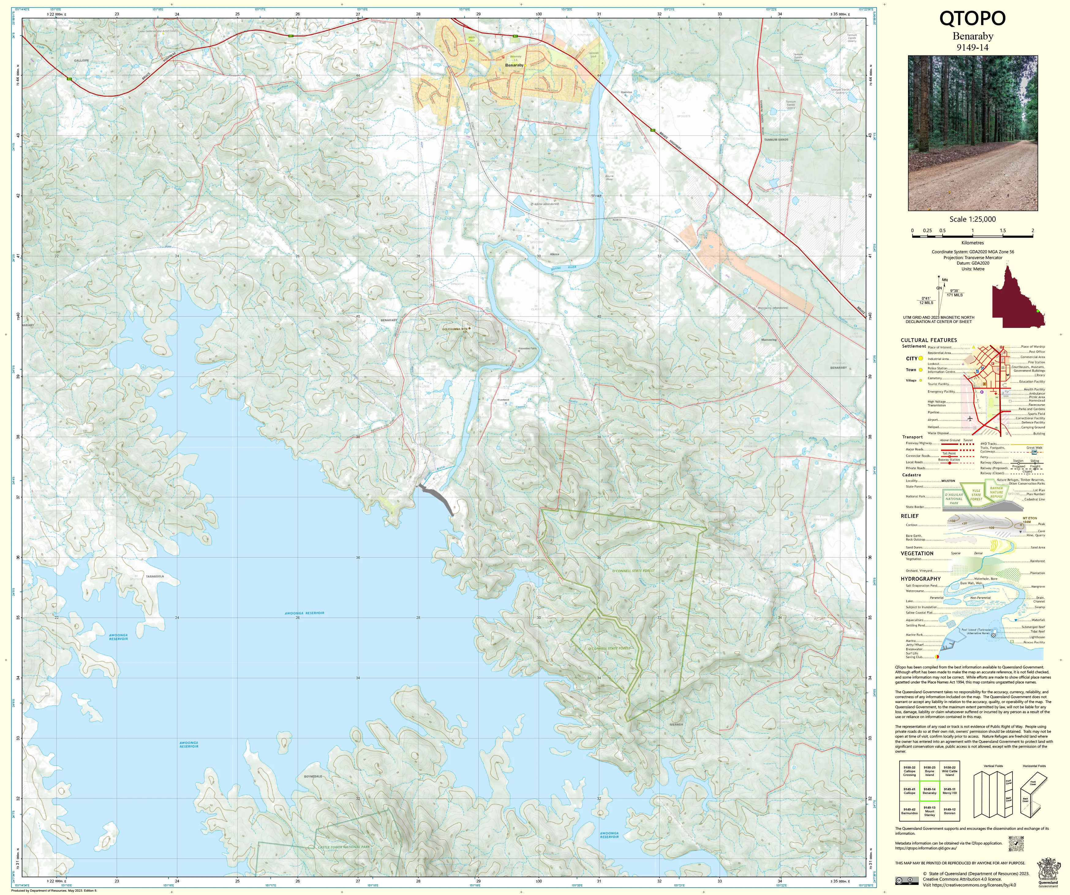
9149-14 Benaraby QTopo 1:25,000 Topographic Map
QTopo 9149-14 — Benaraby
1:25,000 Topographic Map
A detailed, field-ready topographic map covering the Benaraby region—situated south of Gladstone and known for its mix of river flats, rural properties, forested ridges, transport corridors, and important environmental zones along the Boyne River.
The QTopo 9149-14 (Benaraby) sheet—produced by the Queensland Department of Resources—is part of Queensland’s authoritative 1:25,000 mapping series. This map provides essential terrain modelling, hydrology detail, and infrastructure mapping used by surveyors, land managers, environmental professionals, emergency services, and outdoor navigators working across the district.
Whether you're conducting ecological assessments, planning rural access, mapping drainage, or navigating around infrastructure and natural features, QTopo 9149-14 delivers the accuracy and confidence required for effective field operations.
🗺️ Map Content and Features
At 1:25,000 scale—where 1 cm = 250 m—this map includes:
-
Contour lines showing ridgelines, hills, slopes, gullies, floodplains, and higher terrain
-
Hydrology features: Boyne River sections, creeks, tributaries, wetlands, waterholes, dams, and drainage systems
-
Roads, local access tracks & transport corridors including the Bruce Highway and regional road links
-
Infrastructure such as rural buildings, fencelines, powerlines, substations, industrial facilities, and utilities
-
Vegetation mapping covering forest, scrub, woodland, cleared farmland, and riparian zones
-
Land tenure boundaries including freehold parcels, reserves, state land, and protected areas
-
Named natural features such as hills, creek lines, floodplains, ridges, and terrain landmarks
-
Points of interest valuable to surveyors, ecologists, emergency responders, and land managers
All QTopo maps draw on Queensland’s authoritative spatial datasets for reliable and up-to-date accuracy.
🧭 Who Uses This Map?
The Benaraby 9149-14 Topographic Map is widely used by:
-
Environmental scientists & ecologists – riparian studies, habitat mapping, and biodiversity monitoring
-
Surveyors & planners – site evaluation, terrain analysis, and infrastructure planning
-
Rural landholders & graziers – land management, paddock planning, and water access
-
Emergency services & SES – flood modelling, fire planning, and rural search & rescue
-
4WD explorers & outdoor travellers – navigating backcountry roads and forest tracks
-
Outdoor educators – teaching contour reading and map interpretation
A dependable reference for both professional and recreational field activities.
💧 Field-Ready Options for Variable Coastal & Inland Conditions
Choose a print format suited to Benaraby’s warm climate, wet-season variability, and diverse terrain.
✅ Waterproof & Tearproof Tyvek®
-
Printed on DuPont™ Tyvek®
-
Fully waterproof, tear-resistant, lightweight, and foldable
-
Ideal for all-weather fieldwork and repeated handling
✅ Laminated Edition
-
Encapsulated in 2 × 80-micron gloss laminate
-
Writeable surface compatible with whiteboard markers
-
Wipe-clean and resistant to moisture, mud, dust, salt spray, and abrasion
📄 Standard Paper Edition
-
Crisp, high-resolution print
-
Best for office use, planning, and occasional field reference
📐 Map Details
Title: QTopo 9149-14 — Benaraby
Publisher: Queensland Department of Resources
Series: QTopo 1:25,000
Scale: 1:25,000 (1 cm = 250 m)
Dimensions: 710 mm (width) × 594 mm (height)
Coverage: Benaraby township surrounds, Boyne River corridor, rural properties, forested ridges, and transport links
Material Options: Paper, laminated, or waterproof Tyvek®
Printed in: Australia
Edition: Latest available (see product listing for publication year)
📥 QTopo Map Index
Need adjoining Gladstone-region coverage?
➡️ Provide nearby sheet numbers—such as 9149-13, 9149-15, or 9249-04—and we’ll locate the correct adjoining maps immediately.
🛒 Ordering & Options
-
Standard folded paper map – ideal for desktop planning
-
Tyvek® waterproof edition – built for rugged, all-weather field conditions
-
Laminated edition – reusable and durable for operational and training use
-
Flat (unfolded) maps available for wall mounting
🎯 Summary
The QTopo 9149-14 — Benaraby Topographic Map provides essential information on terrain, hydrology, vegetation, and infrastructure across a key part of central coastal Queensland. With precise 1:25,000 mapping and field-hardened print options, it is indispensable for surveyors, ecologists, emergency services, engineers, and outdoor explorers.
Plan with purpose.
Navigate with confidence.
Explore with clarity.
Choose your preferred finish today and take Benaraby into the field with Queensland’s most trusted topographic mapping.
Original: $14.27
-65%$14.27
$4.99Product Information
Product Information
Shipping & Returns
Shipping & Returns
Description
QTopo 9149-14 — Benaraby
1:25,000 Topographic Map
A detailed, field-ready topographic map covering the Benaraby region—situated south of Gladstone and known for its mix of river flats, rural properties, forested ridges, transport corridors, and important environmental zones along the Boyne River.
The QTopo 9149-14 (Benaraby) sheet—produced by the Queensland Department of Resources—is part of Queensland’s authoritative 1:25,000 mapping series. This map provides essential terrain modelling, hydrology detail, and infrastructure mapping used by surveyors, land managers, environmental professionals, emergency services, and outdoor navigators working across the district.
Whether you're conducting ecological assessments, planning rural access, mapping drainage, or navigating around infrastructure and natural features, QTopo 9149-14 delivers the accuracy and confidence required for effective field operations.
🗺️ Map Content and Features
At 1:25,000 scale—where 1 cm = 250 m—this map includes:
-
Contour lines showing ridgelines, hills, slopes, gullies, floodplains, and higher terrain
-
Hydrology features: Boyne River sections, creeks, tributaries, wetlands, waterholes, dams, and drainage systems
-
Roads, local access tracks & transport corridors including the Bruce Highway and regional road links
-
Infrastructure such as rural buildings, fencelines, powerlines, substations, industrial facilities, and utilities
-
Vegetation mapping covering forest, scrub, woodland, cleared farmland, and riparian zones
-
Land tenure boundaries including freehold parcels, reserves, state land, and protected areas
-
Named natural features such as hills, creek lines, floodplains, ridges, and terrain landmarks
-
Points of interest valuable to surveyors, ecologists, emergency responders, and land managers
All QTopo maps draw on Queensland’s authoritative spatial datasets for reliable and up-to-date accuracy.
🧭 Who Uses This Map?
The Benaraby 9149-14 Topographic Map is widely used by:
-
Environmental scientists & ecologists – riparian studies, habitat mapping, and biodiversity monitoring
-
Surveyors & planners – site evaluation, terrain analysis, and infrastructure planning
-
Rural landholders & graziers – land management, paddock planning, and water access
-
Emergency services & SES – flood modelling, fire planning, and rural search & rescue
-
4WD explorers & outdoor travellers – navigating backcountry roads and forest tracks
-
Outdoor educators – teaching contour reading and map interpretation
A dependable reference for both professional and recreational field activities.
💧 Field-Ready Options for Variable Coastal & Inland Conditions
Choose a print format suited to Benaraby’s warm climate, wet-season variability, and diverse terrain.
✅ Waterproof & Tearproof Tyvek®
-
Printed on DuPont™ Tyvek®
-
Fully waterproof, tear-resistant, lightweight, and foldable
-
Ideal for all-weather fieldwork and repeated handling
✅ Laminated Edition
-
Encapsulated in 2 × 80-micron gloss laminate
-
Writeable surface compatible with whiteboard markers
-
Wipe-clean and resistant to moisture, mud, dust, salt spray, and abrasion
📄 Standard Paper Edition
-
Crisp, high-resolution print
-
Best for office use, planning, and occasional field reference
📐 Map Details
Title: QTopo 9149-14 — Benaraby
Publisher: Queensland Department of Resources
Series: QTopo 1:25,000
Scale: 1:25,000 (1 cm = 250 m)
Dimensions: 710 mm (width) × 594 mm (height)
Coverage: Benaraby township surrounds, Boyne River corridor, rural properties, forested ridges, and transport links
Material Options: Paper, laminated, or waterproof Tyvek®
Printed in: Australia
Edition: Latest available (see product listing for publication year)
📥 QTopo Map Index
Need adjoining Gladstone-region coverage?
➡️ Provide nearby sheet numbers—such as 9149-13, 9149-15, or 9249-04—and we’ll locate the correct adjoining maps immediately.
🛒 Ordering & Options
-
Standard folded paper map – ideal for desktop planning
-
Tyvek® waterproof edition – built for rugged, all-weather field conditions
-
Laminated edition – reusable and durable for operational and training use
-
Flat (unfolded) maps available for wall mounting
🎯 Summary
The QTopo 9149-14 — Benaraby Topographic Map provides essential information on terrain, hydrology, vegetation, and infrastructure across a key part of central coastal Queensland. With precise 1:25,000 mapping and field-hardened print options, it is indispensable for surveyors, ecologists, emergency services, engineers, and outdoor explorers.
Plan with purpose.
Navigate with confidence.
Explore with clarity.
Choose your preferred finish today and take Benaraby into the field with Queensland’s most trusted topographic mapping.


