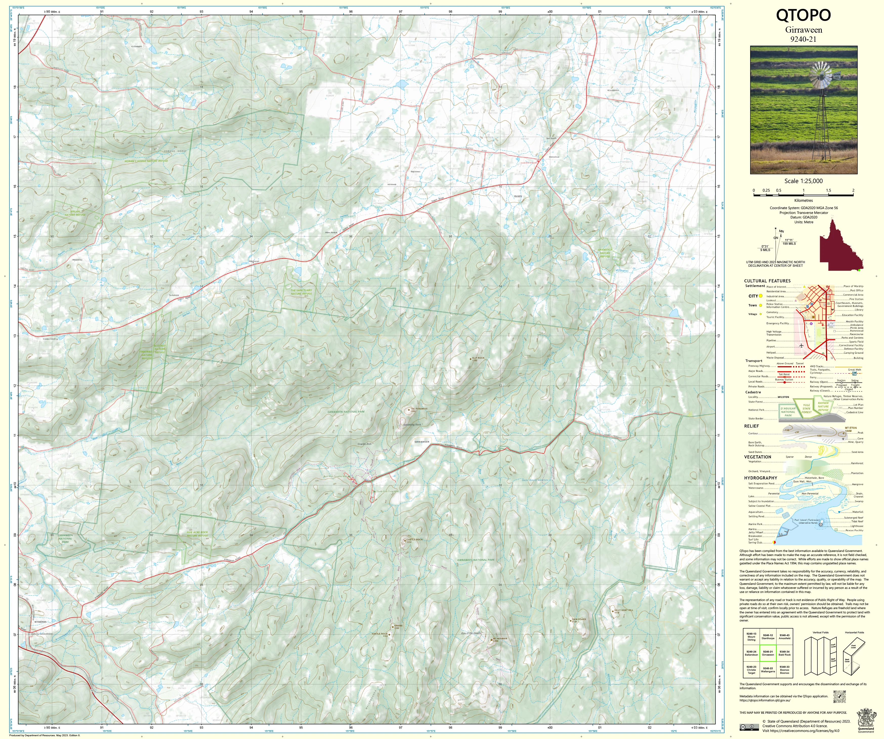
9240-21 Girraween QTopo 1:25,000 Topographic Map
QTopo 9240-21 — Girraween
1:25,000 Topographic Map
A high-precision topographic map covering the spectacular Girraween region on the Queensland–New South Wales border—an area renowned for its dramatic granite outcrops, massive boulders, creek systems, rugged heathland, and the iconic landscapes surrounding Girraween National Park.
The QTopo 9240-21 (Girraween) sheet—produced by the Queensland Department of Resources—forms part of Queensland’s authoritative 1:25,000 topographic series. Known for its distinctive terrain, the Girraween area includes steep granite domes, exposed ridgelines, dense eucalypt forest, and winding creeks, making accurate mapping indispensable for hikers, researchers, land managers, and emergency services.
Whether you're planning a bushwalk to the Pyramid, conducting ecological fieldwork, assessing creek catchments, or navigating remote access tracks, QTopo 9240-21 offers the clarity and precision required for confident, informed navigation.
🗺️ Map Content and Features
At 1:25,000 scale—where 1 cm = 250 m—this map includes:
-
Contour lines detailing steep slopes, granite domes, ridgelines, erratics, and valley systems
-
Hydrology features: Bald Rock Creek, tributaries, drainage channels, waterholes, and seasonal flow paths
-
Walking tracks, park access roads & fire trails throughout the Girraween National Park surrounds
-
Infrastructure such as picnic areas, campsites, parking areas, fencelines, shelters, and visitor facilities
-
Vegetation mapping including open forest, heath, woodland, granite shrublands, and cleared pockets
-
Land tenure boundaries outlining national park, state-managed land, and adjoining private property
-
Named natural features like The Pyramid, Castle Rock, granite tors, creek bends, and local peaks
-
Points of interest for hikers, ecologists, rangers, geologists, and emergency personnel
All QTopo maps use Queensland’s authoritative spatial datasets for dependable accuracy and consistency.
🧭 Who Uses This Map?
The Girraween 9240-21 Topographic Map is essential for:
-
Bushwalkers & hikers – navigating trails, ridgelines, creek crossings, and iconic granite formations
-
Environmental scientists & ecologists – flora/fauna surveys, habitat mapping, and fire ecology studies
-
Surveyors & planners – terrain modelling, boundary assessments, and infrastructure planning
-
Emergency services & SES – wildfire response, search & rescue, and hazard mapping
-
Outdoor educators & adventure groups – teaching navigation and landform interpretation
-
Geologists & geomorphologists – studying granite landscapes and erosion patterns
A trusted tool for both professional and recreational users.
💧 Field-Ready Options for Granite Country & All-Weather Conditions
Choose a format suited to Girraween’s rugged terrain, wet-season storms, and exposed landscapes.
✅ Waterproof & Tearproof Tyvek®
-
Printed on DuPont™ Tyvek®
-
Fully waterproof, tear-resistant, rugged, lightweight, and foldable
-
Ideal for bushwalking, creek crossings, field research, and severe-weather conditions
✅ Laminated Edition
-
Encapsulated in 2 × 80-micron gloss laminate
-
Writeable surface for whiteboard markers
-
Wipe-clean and resistant to moisture, dirt, dust, and abrasion
📄 Standard Paper Edition
-
Crisp, high-resolution printing
-
Perfect for planning, office reference, or occasional light field use
📐 Map Details
Title: QTopo 9240-21 — Girraween
Publisher: Queensland Department of Resources
Series: QTopo 1:25,000
Scale: 1:25,000 (1 cm = 250 m)
Dimensions: 710 mm (width) × 594 mm (height)
Coverage: Girraween National Park surrounds, granite formations, ridgelines, creek systems, forests, and rural edges
Material Options: Paper, laminated, or waterproof Tyvek®
Printed in: Australia
Edition: Latest available (see listing for publication year)
📥 QTopo Map Index
Need adjoining Stanthorpe–Wallangarra–Girraween coverage?
➡️ Share nearby sheet numbers—such as 9240-11, 9140-22, or 9340-01—and I’ll identify the adjoining maps instantly.
🛒 Ordering & Options
-
Standard folded paper map – ideal for office use and planning
-
Tyvek® waterproof edition – best for rugged field conditions and wet-weather hikes
-
Laminated edition – durable, reusable, and perfect for navigation training
-
Flat (unfolded) maps available for wall display or workshops
🎯 Summary
The QTopo 9240-21 — Girraween Topographic Map provides essential detail on terrain, hydrology, vegetation, and access across one of Queensland’s most striking granite landscapes. With precise 1:25,000 mapping and durable field-ready formats, it is indispensable for hikers, ecologists, surveyors, emergency crews, and outdoor educators.
Plan with purpose.
Navigate with confidence.
Explore with clarity.
Choose your preferred finish today and take Girraween into the field with Queensland’s most trusted topographic mapping.
Original: $14.27
-65%$14.27
$4.99Product Information
Product Information
Shipping & Returns
Shipping & Returns
Description
QTopo 9240-21 — Girraween
1:25,000 Topographic Map
A high-precision topographic map covering the spectacular Girraween region on the Queensland–New South Wales border—an area renowned for its dramatic granite outcrops, massive boulders, creek systems, rugged heathland, and the iconic landscapes surrounding Girraween National Park.
The QTopo 9240-21 (Girraween) sheet—produced by the Queensland Department of Resources—forms part of Queensland’s authoritative 1:25,000 topographic series. Known for its distinctive terrain, the Girraween area includes steep granite domes, exposed ridgelines, dense eucalypt forest, and winding creeks, making accurate mapping indispensable for hikers, researchers, land managers, and emergency services.
Whether you're planning a bushwalk to the Pyramid, conducting ecological fieldwork, assessing creek catchments, or navigating remote access tracks, QTopo 9240-21 offers the clarity and precision required for confident, informed navigation.
🗺️ Map Content and Features
At 1:25,000 scale—where 1 cm = 250 m—this map includes:
-
Contour lines detailing steep slopes, granite domes, ridgelines, erratics, and valley systems
-
Hydrology features: Bald Rock Creek, tributaries, drainage channels, waterholes, and seasonal flow paths
-
Walking tracks, park access roads & fire trails throughout the Girraween National Park surrounds
-
Infrastructure such as picnic areas, campsites, parking areas, fencelines, shelters, and visitor facilities
-
Vegetation mapping including open forest, heath, woodland, granite shrublands, and cleared pockets
-
Land tenure boundaries outlining national park, state-managed land, and adjoining private property
-
Named natural features like The Pyramid, Castle Rock, granite tors, creek bends, and local peaks
-
Points of interest for hikers, ecologists, rangers, geologists, and emergency personnel
All QTopo maps use Queensland’s authoritative spatial datasets for dependable accuracy and consistency.
🧭 Who Uses This Map?
The Girraween 9240-21 Topographic Map is essential for:
-
Bushwalkers & hikers – navigating trails, ridgelines, creek crossings, and iconic granite formations
-
Environmental scientists & ecologists – flora/fauna surveys, habitat mapping, and fire ecology studies
-
Surveyors & planners – terrain modelling, boundary assessments, and infrastructure planning
-
Emergency services & SES – wildfire response, search & rescue, and hazard mapping
-
Outdoor educators & adventure groups – teaching navigation and landform interpretation
-
Geologists & geomorphologists – studying granite landscapes and erosion patterns
A trusted tool for both professional and recreational users.
💧 Field-Ready Options for Granite Country & All-Weather Conditions
Choose a format suited to Girraween’s rugged terrain, wet-season storms, and exposed landscapes.
✅ Waterproof & Tearproof Tyvek®
-
Printed on DuPont™ Tyvek®
-
Fully waterproof, tear-resistant, rugged, lightweight, and foldable
-
Ideal for bushwalking, creek crossings, field research, and severe-weather conditions
✅ Laminated Edition
-
Encapsulated in 2 × 80-micron gloss laminate
-
Writeable surface for whiteboard markers
-
Wipe-clean and resistant to moisture, dirt, dust, and abrasion
📄 Standard Paper Edition
-
Crisp, high-resolution printing
-
Perfect for planning, office reference, or occasional light field use
📐 Map Details
Title: QTopo 9240-21 — Girraween
Publisher: Queensland Department of Resources
Series: QTopo 1:25,000
Scale: 1:25,000 (1 cm = 250 m)
Dimensions: 710 mm (width) × 594 mm (height)
Coverage: Girraween National Park surrounds, granite formations, ridgelines, creek systems, forests, and rural edges
Material Options: Paper, laminated, or waterproof Tyvek®
Printed in: Australia
Edition: Latest available (see listing for publication year)
📥 QTopo Map Index
Need adjoining Stanthorpe–Wallangarra–Girraween coverage?
➡️ Share nearby sheet numbers—such as 9240-11, 9140-22, or 9340-01—and I’ll identify the adjoining maps instantly.
🛒 Ordering & Options
-
Standard folded paper map – ideal for office use and planning
-
Tyvek® waterproof edition – best for rugged field conditions and wet-weather hikes
-
Laminated edition – durable, reusable, and perfect for navigation training
-
Flat (unfolded) maps available for wall display or workshops
🎯 Summary
The QTopo 9240-21 — Girraween Topographic Map provides essential detail on terrain, hydrology, vegetation, and access across one of Queensland’s most striking granite landscapes. With precise 1:25,000 mapping and durable field-ready formats, it is indispensable for hikers, ecologists, surveyors, emergency crews, and outdoor educators.
Plan with purpose.
Navigate with confidence.
Explore with clarity.
Choose your preferred finish today and take Girraween into the field with Queensland’s most trusted topographic mapping.


