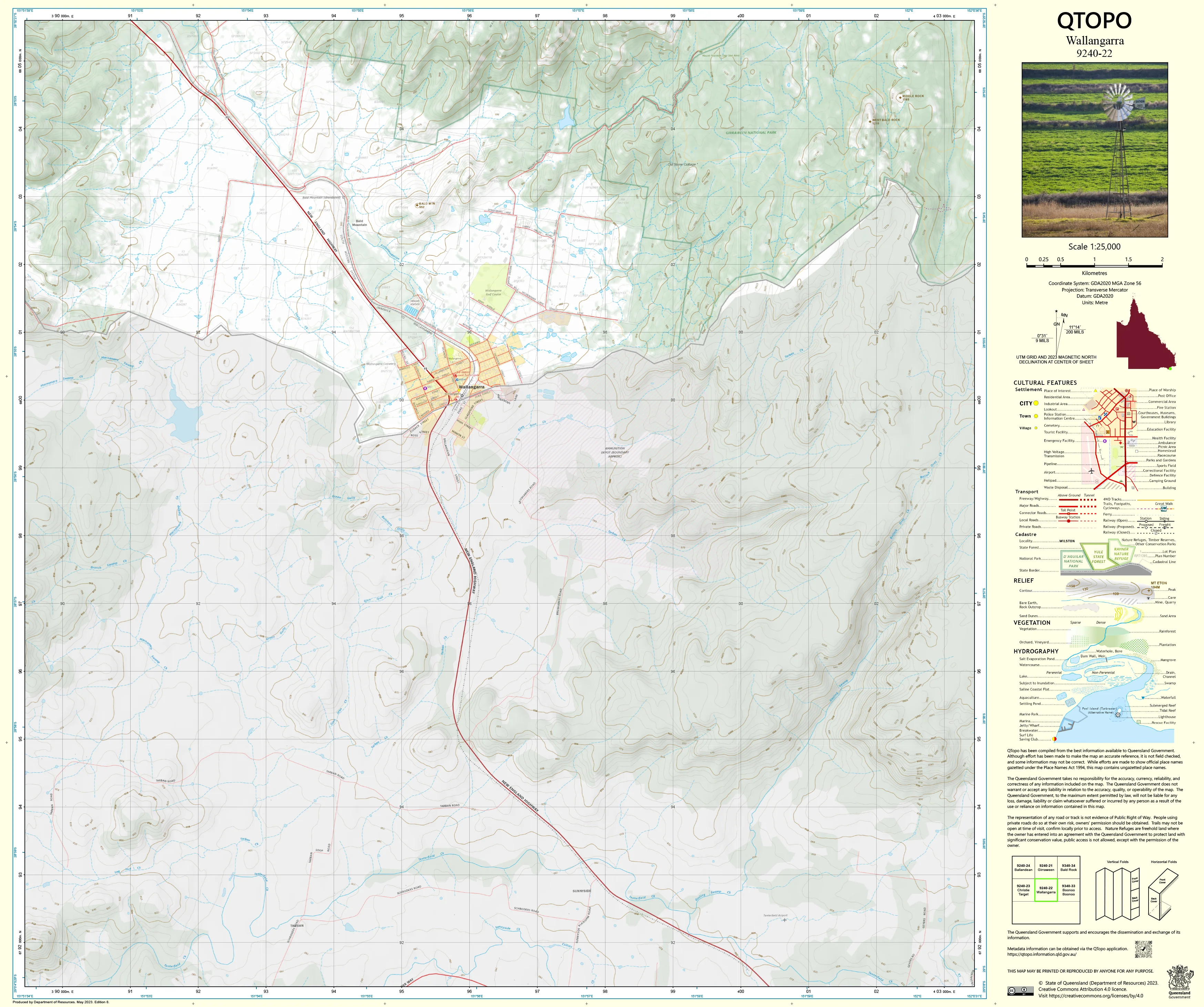
9240-22 Wallangarra QTopo 1:25,000 Topographic Map
QTopo 9240-22 — Wallangarra
1:25,000 Topographic Map
A detailed, high-precision topographic map covering the Wallangarra region—Queensland’s southernmost township and a key border point with New South Wales. This area is characterised by elevated granite country, rolling hills, creek corridors, agricultural land, transport links, and the gateway to Girraween and Bald Rock country.
The QTopo 9240-22 (Wallangarra) sheet—produced by the Queensland Department of Resources—forms part of the authoritative 1:25,000 topographic series. With its complex mix of rural landscapes, steep granite ridges, forest patches, and cross-border access routes, this map is essential for surveyors, emergency services, environmental scientists, graziers, and bushwalkers.
Whether you’re navigating rural roads near the border, assessing catchments, conducting ecological fieldwork, or planning outdoor adventures in the surrounding highlands, QTopo 9240-22 delivers the clarity and accuracy you need in the field.
🗺️ Map Content and Features
At 1:25,000 scale—where 1 cm = 250 m—the map includes:
-
Contour lines showing granite ridges, hills, slopes, gullies, and elevated terrain
-
Hydrology features: creek systems, waterholes, drainage lines, and seasonal channels
-
Roads, local access tracks & rural connectors linking Wallangarra with Girraween, Jennings, and surrounding properties
-
Infrastructure such as homesteads, fencelines, powerlines, rail alignment remnants, and utility installations
-
Vegetation mapping covering woodland, forest, scrub, open farmland, and riparian vegetation
-
Land tenure boundaries: freehold lots, reserves, national park boundaries, and state land
-
Named natural features including hills, creek corridors, plains, and distinctive granite formations
-
Points of interest for ecologists, surveyors, landholders, emergency responders, and bushwalkers
All QTopo maps are built from Queensland’s authoritative spatial datasets to ensure accuracy and consistency.
🧭 Who Uses This Map?
The Wallangarra 9240-22 Topographic Map is commonly used by:
-
Surveyors & planners – terrain modelling, boundary work, and infrastructure assessment
-
Environmental scientists & ecologists – flora/fauna surveys, fire ecology studies, and habitat mapping
-
Graziers & rural landholders – paddock planning, water management, and property access
-
Emergency services & SES – fire planning, flood modelling, and rural search & rescue
-
4WD travellers & hikers – exploring Wallangarra, Girraween surrounds, and border tracks
-
Outdoor educators & field instructors – teaching topographic navigation and contour interpretation
A trusted reference for both professional and recreational users.
💧 Field-Ready Options for Highland & Border-Region Conditions
Choose a format built for Wallangarra’s cool winters, sudden storms, and rugged granite terrain.
✅ Waterproof & Tearproof Tyvek®
-
Printed on DuPont™ Tyvek®
-
Fully waterproof, tear-resistant, lightweight, and foldable
-
Ideal for creek crossings, fieldwork, hiking, and all-weather use
✅ Laminated Edition
-
Encapsulated in 2 × 80-micron gloss laminate
-
Writeable surface suitable for whiteboard markers
-
Wipe-clean and resistant to moisture, dirt, and abrasion
📄 Standard Paper Edition
-
High-resolution printing
-
Suitable for planning, referencing, and occasional field use
📐 Map Details
Title: QTopo 9240-22 — Wallangarra
Publisher: Queensland Department of Resources
Series: QTopo 1:25,000
Scale: 1:25,000 (1 cm = 250 m)
Dimensions: 710 mm (width) × 594 mm (height)
Coverage: Wallangarra township surrounds, border region terrain, creek systems, rural properties, and highland ridges
Material Options: Paper, laminated, or waterproof Tyvek®
Printed in: Australia
Edition: Latest available (see listing for publication year)
📥 QTopo Map Index
Need neighbouring border-region coverage?
➡️ Share adjacent sheet numbers—such as 9240-21, 9140-23, or 9340-02—and I’ll identify the correct adjoining maps instantly.
🛒 Ordering & Options
-
Standard folded paper map – ideal for office and planning use
-
Tyvek® waterproof edition – rugged, durable, and suited to all-weather fieldwork
-
Laminated edition – reusable and long-lasting for training or field operations
-
Flat (unfolded) maps available for display or workshop environments
🎯 Summary
The QTopo 9240-22 — Wallangarra Topographic Map provides essential terrain, hydrological, vegetation, and access detail across this key border region and surrounding granite highlands. With precise 1:25,000 mapping and rugged print formats, it is indispensable for surveyors, ecologists, emergency services, landholders, and explorers.
Plan with purpose.
Navigate with confidence.
Explore with clarity.
Choose your preferred finish today and take Wallangarra into the field with Queensland’s most trusted topographic mapping.
Original: $14.27
-65%$14.27
$4.99Product Information
Product Information
Shipping & Returns
Shipping & Returns
Description
QTopo 9240-22 — Wallangarra
1:25,000 Topographic Map
A detailed, high-precision topographic map covering the Wallangarra region—Queensland’s southernmost township and a key border point with New South Wales. This area is characterised by elevated granite country, rolling hills, creek corridors, agricultural land, transport links, and the gateway to Girraween and Bald Rock country.
The QTopo 9240-22 (Wallangarra) sheet—produced by the Queensland Department of Resources—forms part of the authoritative 1:25,000 topographic series. With its complex mix of rural landscapes, steep granite ridges, forest patches, and cross-border access routes, this map is essential for surveyors, emergency services, environmental scientists, graziers, and bushwalkers.
Whether you’re navigating rural roads near the border, assessing catchments, conducting ecological fieldwork, or planning outdoor adventures in the surrounding highlands, QTopo 9240-22 delivers the clarity and accuracy you need in the field.
🗺️ Map Content and Features
At 1:25,000 scale—where 1 cm = 250 m—the map includes:
-
Contour lines showing granite ridges, hills, slopes, gullies, and elevated terrain
-
Hydrology features: creek systems, waterholes, drainage lines, and seasonal channels
-
Roads, local access tracks & rural connectors linking Wallangarra with Girraween, Jennings, and surrounding properties
-
Infrastructure such as homesteads, fencelines, powerlines, rail alignment remnants, and utility installations
-
Vegetation mapping covering woodland, forest, scrub, open farmland, and riparian vegetation
-
Land tenure boundaries: freehold lots, reserves, national park boundaries, and state land
-
Named natural features including hills, creek corridors, plains, and distinctive granite formations
-
Points of interest for ecologists, surveyors, landholders, emergency responders, and bushwalkers
All QTopo maps are built from Queensland’s authoritative spatial datasets to ensure accuracy and consistency.
🧭 Who Uses This Map?
The Wallangarra 9240-22 Topographic Map is commonly used by:
-
Surveyors & planners – terrain modelling, boundary work, and infrastructure assessment
-
Environmental scientists & ecologists – flora/fauna surveys, fire ecology studies, and habitat mapping
-
Graziers & rural landholders – paddock planning, water management, and property access
-
Emergency services & SES – fire planning, flood modelling, and rural search & rescue
-
4WD travellers & hikers – exploring Wallangarra, Girraween surrounds, and border tracks
-
Outdoor educators & field instructors – teaching topographic navigation and contour interpretation
A trusted reference for both professional and recreational users.
💧 Field-Ready Options for Highland & Border-Region Conditions
Choose a format built for Wallangarra’s cool winters, sudden storms, and rugged granite terrain.
✅ Waterproof & Tearproof Tyvek®
-
Printed on DuPont™ Tyvek®
-
Fully waterproof, tear-resistant, lightweight, and foldable
-
Ideal for creek crossings, fieldwork, hiking, and all-weather use
✅ Laminated Edition
-
Encapsulated in 2 × 80-micron gloss laminate
-
Writeable surface suitable for whiteboard markers
-
Wipe-clean and resistant to moisture, dirt, and abrasion
📄 Standard Paper Edition
-
High-resolution printing
-
Suitable for planning, referencing, and occasional field use
📐 Map Details
Title: QTopo 9240-22 — Wallangarra
Publisher: Queensland Department of Resources
Series: QTopo 1:25,000
Scale: 1:25,000 (1 cm = 250 m)
Dimensions: 710 mm (width) × 594 mm (height)
Coverage: Wallangarra township surrounds, border region terrain, creek systems, rural properties, and highland ridges
Material Options: Paper, laminated, or waterproof Tyvek®
Printed in: Australia
Edition: Latest available (see listing for publication year)
📥 QTopo Map Index
Need neighbouring border-region coverage?
➡️ Share adjacent sheet numbers—such as 9240-21, 9140-23, or 9340-02—and I’ll identify the correct adjoining maps instantly.
🛒 Ordering & Options
-
Standard folded paper map – ideal for office and planning use
-
Tyvek® waterproof edition – rugged, durable, and suited to all-weather fieldwork
-
Laminated edition – reusable and long-lasting for training or field operations
-
Flat (unfolded) maps available for display or workshop environments
🎯 Summary
The QTopo 9240-22 — Wallangarra Topographic Map provides essential terrain, hydrological, vegetation, and access detail across this key border region and surrounding granite highlands. With precise 1:25,000 mapping and rugged print formats, it is indispensable for surveyors, ecologists, emergency services, landholders, and explorers.
Plan with purpose.
Navigate with confidence.
Explore with clarity.
Choose your preferred finish today and take Wallangarra into the field with Queensland’s most trusted topographic mapping.


