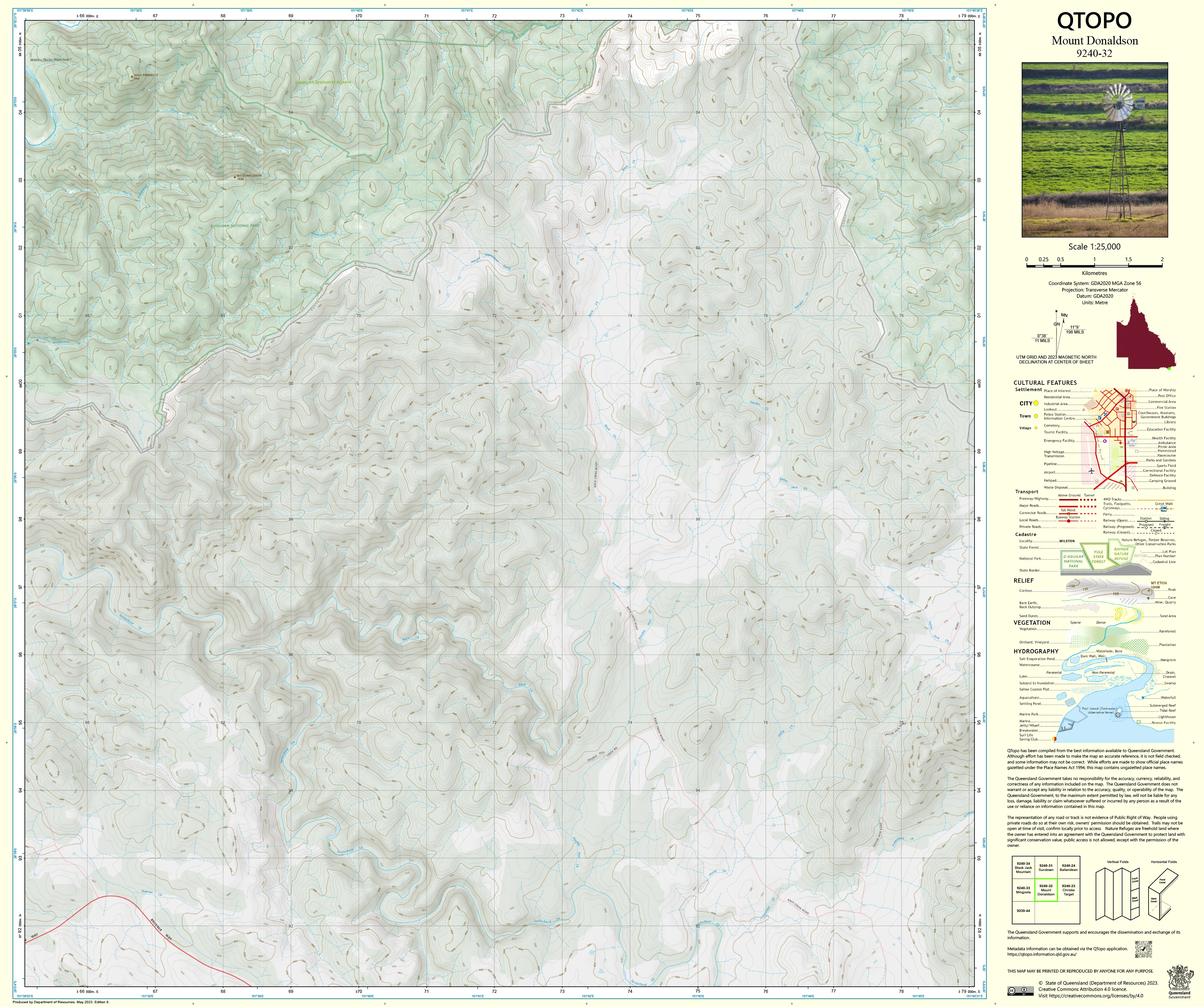
9240-32 Mount Donaldson QTopo 1:25,000 Topographic Map
QTopo 9240-31 — Sundown
1:25,000 Topographic Map
A high-precision topographic map covering the rugged Sundown region—part of the dramatic high-country terrain straddling the Queensland–New South Wales border. Known for its steep gorges, granite ridges, remote valleys, and winding creeks, the Sundown area offers some of the most challenging and rewarding backcountry in the region.
The QTopo 9240-31 (Sundown) sheet—produced by the Queensland Department of Resources—forms part of Queensland’s authoritative 1:25,000 mapping series. With sharply defined contours, hydrological detail, and accurate representations of remote access routes, this map is indispensable for surveyors, ecologists, rangers, rescue teams, and experienced hikers.
Whether you’re navigating remote creek beds, conducting ecological assessments, planning backcountry access, or travelling between steep ridgelines and valley floors, QTopo 9240-31 delivers the accuracy and dependability required for safe, informed field operations.
🗺️ Map Content and Features
At 1:25,000 scale—where 1 cm = 250 m—the map features:
-
Contour lines highlighting steep slopes, cliffs, ridgelines, granite formations, knolls, and narrow valleys
-
Hydrology features: winding creeks, drainage lines, seasonal flows, rock pools, and gorge systems
-
Access routes & tracks including 4WD routes, bush tracks, and links into Sundown National Park areas
-
Infrastructure such as huts, fencelines, water points, communication assets, and minor rural structures
-
Vegetation mapping showing forest, woodland, scrub, heathland, and open rocky country
-
Land tenure boundaries: national park edges, conservation land, private property, and state land
-
Named natural features including peaks, creek corridors, gorge sections, and iconic granite outcrops
-
Points of interest valuable for rangers, ecologists, hikers, and remote-area navigators
All QTopo maps are built on Queensland’s authoritative spatial datasets for accuracy and consistency across the series.
🧭 Who Uses This Map?
The Sundown 9240-31 Topographic Map is widely used by:
-
Rangers & conservation staff – managing protected lands and monitoring ecosystems
-
Environmental scientists & ecologists – habitat mapping, survey planning, flora/fauna assessments
-
Surveyors & land planners – landform interpretation, boundary work, and site assessments
-
Emergency services & SES – bushfire planning, flood modelling, and remote search & rescue
-
Experienced bushwalkers & 4WD adventurers – navigating some of the steepest terrain in the region
-
Outdoor educators & field instructors – teaching advanced navigation and topographic reading
A trusted tool for both professional and advanced recreational users.
💧 Field-Ready Options for Harsh Highland Conditions
Choose a finish suited to Sundown’s rugged landscapes, deep gorges, and volatile weather.
✅ Waterproof & Tearproof Tyvek®
-
Printed on DuPont™ Tyvek®
-
Fully waterproof, tear-resistant, lightweight, and long-lasting
-
Ideal for creek crossings, gorge exploration, and wet or windy conditions
✅ Laminated Edition
-
Encapsulated in 2 × 80-micron gloss laminate
-
Writeable surface for planning routes and marking survey points
-
Wipe-clean and resistant to moisture, mud, dirt, and abrasion
📄 Standard Paper Edition
-
Crisp, high-quality print
-
Suitable for office planning, reference, and occasional field use
📐 Map Details
Title: QTopo 9240-31 — Sundown
Publisher: Queensland Department of Resources
Series: QTopo 1:25,000
Scale: 1:25,000 (1 cm = 250 m)
Dimensions: 710 mm (width) × 594 mm (height)
Coverage: Sundown region including gorges, creeks, ridgelines, steep slopes, conservation areas, and remote high-country terrain
Material Options: Paper, laminated, or waterproof Tyvek®
Printed in: Australia
Edition: Latest available (see listing for publication year)
📥 QTopo Map Index
Need adjoining sheets in the Sundown–Stanthorpe–Border Ranges area?
➡️ Share adjacent sheet numbers—such as 9240-21, 9240-32, or 9340-11—and I’ll locate the relevant maps instantly.
🛒 Ordering & Options
-
Standard folded paper map – ideal for planning and desktop use
-
Tyvek® waterproof edition – best for rugged, remote-area fieldwork
-
Laminated edition – durable, reusable, and ideal for operational and training purposes
-
Flat (unfolded) maps available for wall display
🎯 Summary
The QTopo 9240-31 — Sundown Topographic Map provides essential detail on terrain, hydrology, vegetation, and access across one of Queensland’s most rugged and striking border landscapes. With precise 1:25,000 mapping and field-tough print options, it is indispensable for surveyors, ecologists, rangers, emergency responders, and experienced explorers.
Plan with purpose.
Navigate with confidence.
Explore with clarity.
Choose your preferred finish today and take Sundown into the field with Queensland’s most trusted topographic mapping.
Original: $14.27
-65%$14.27
$4.99Product Information
Product Information
Shipping & Returns
Shipping & Returns
Description
QTopo 9240-31 — Sundown
1:25,000 Topographic Map
A high-precision topographic map covering the rugged Sundown region—part of the dramatic high-country terrain straddling the Queensland–New South Wales border. Known for its steep gorges, granite ridges, remote valleys, and winding creeks, the Sundown area offers some of the most challenging and rewarding backcountry in the region.
The QTopo 9240-31 (Sundown) sheet—produced by the Queensland Department of Resources—forms part of Queensland’s authoritative 1:25,000 mapping series. With sharply defined contours, hydrological detail, and accurate representations of remote access routes, this map is indispensable for surveyors, ecologists, rangers, rescue teams, and experienced hikers.
Whether you’re navigating remote creek beds, conducting ecological assessments, planning backcountry access, or travelling between steep ridgelines and valley floors, QTopo 9240-31 delivers the accuracy and dependability required for safe, informed field operations.
🗺️ Map Content and Features
At 1:25,000 scale—where 1 cm = 250 m—the map features:
-
Contour lines highlighting steep slopes, cliffs, ridgelines, granite formations, knolls, and narrow valleys
-
Hydrology features: winding creeks, drainage lines, seasonal flows, rock pools, and gorge systems
-
Access routes & tracks including 4WD routes, bush tracks, and links into Sundown National Park areas
-
Infrastructure such as huts, fencelines, water points, communication assets, and minor rural structures
-
Vegetation mapping showing forest, woodland, scrub, heathland, and open rocky country
-
Land tenure boundaries: national park edges, conservation land, private property, and state land
-
Named natural features including peaks, creek corridors, gorge sections, and iconic granite outcrops
-
Points of interest valuable for rangers, ecologists, hikers, and remote-area navigators
All QTopo maps are built on Queensland’s authoritative spatial datasets for accuracy and consistency across the series.
🧭 Who Uses This Map?
The Sundown 9240-31 Topographic Map is widely used by:
-
Rangers & conservation staff – managing protected lands and monitoring ecosystems
-
Environmental scientists & ecologists – habitat mapping, survey planning, flora/fauna assessments
-
Surveyors & land planners – landform interpretation, boundary work, and site assessments
-
Emergency services & SES – bushfire planning, flood modelling, and remote search & rescue
-
Experienced bushwalkers & 4WD adventurers – navigating some of the steepest terrain in the region
-
Outdoor educators & field instructors – teaching advanced navigation and topographic reading
A trusted tool for both professional and advanced recreational users.
💧 Field-Ready Options for Harsh Highland Conditions
Choose a finish suited to Sundown’s rugged landscapes, deep gorges, and volatile weather.
✅ Waterproof & Tearproof Tyvek®
-
Printed on DuPont™ Tyvek®
-
Fully waterproof, tear-resistant, lightweight, and long-lasting
-
Ideal for creek crossings, gorge exploration, and wet or windy conditions
✅ Laminated Edition
-
Encapsulated in 2 × 80-micron gloss laminate
-
Writeable surface for planning routes and marking survey points
-
Wipe-clean and resistant to moisture, mud, dirt, and abrasion
📄 Standard Paper Edition
-
Crisp, high-quality print
-
Suitable for office planning, reference, and occasional field use
📐 Map Details
Title: QTopo 9240-31 — Sundown
Publisher: Queensland Department of Resources
Series: QTopo 1:25,000
Scale: 1:25,000 (1 cm = 250 m)
Dimensions: 710 mm (width) × 594 mm (height)
Coverage: Sundown region including gorges, creeks, ridgelines, steep slopes, conservation areas, and remote high-country terrain
Material Options: Paper, laminated, or waterproof Tyvek®
Printed in: Australia
Edition: Latest available (see listing for publication year)
📥 QTopo Map Index
Need adjoining sheets in the Sundown–Stanthorpe–Border Ranges area?
➡️ Share adjacent sheet numbers—such as 9240-21, 9240-32, or 9340-11—and I’ll locate the relevant maps instantly.
🛒 Ordering & Options
-
Standard folded paper map – ideal for planning and desktop use
-
Tyvek® waterproof edition – best for rugged, remote-area fieldwork
-
Laminated edition – durable, reusable, and ideal for operational and training purposes
-
Flat (unfolded) maps available for wall display
🎯 Summary
The QTopo 9240-31 — Sundown Topographic Map provides essential detail on terrain, hydrology, vegetation, and access across one of Queensland’s most rugged and striking border landscapes. With precise 1:25,000 mapping and field-tough print options, it is indispensable for surveyors, ecologists, rangers, emergency responders, and experienced explorers.
Plan with purpose.
Navigate with confidence.
Explore with clarity.
Choose your preferred finish today and take Sundown into the field with Queensland’s most trusted topographic mapping.


