9245-23 Memerambi QTopo 1:25,000 Topographic Map
QTopo 9245-23 — Memerambi
1:25,000 Topographic Map
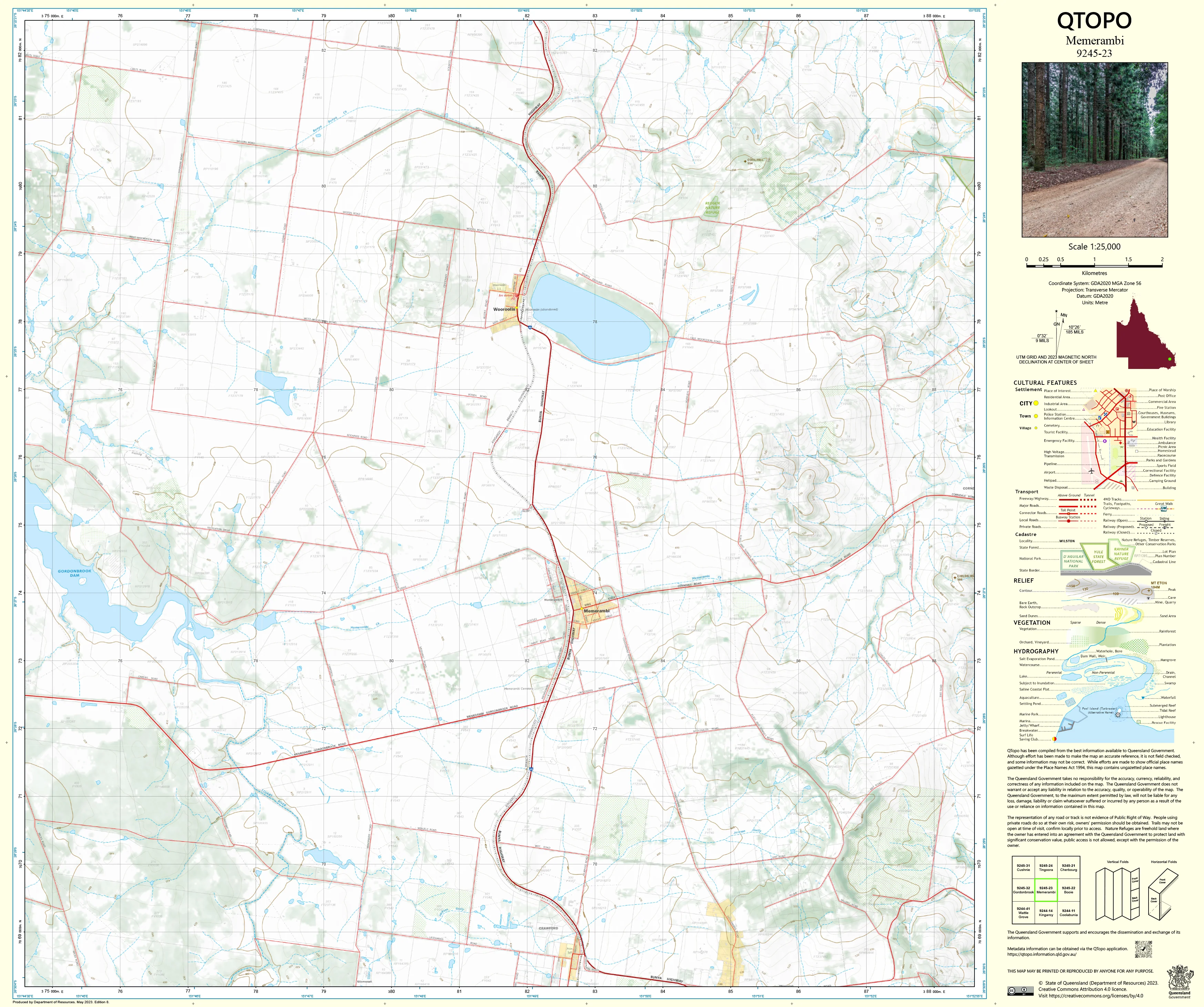
A high-precision topographic map covering the Memerambi region—situated north of Kingaroy and known for its rich agricultural land, gently undulating hills, creek corridors, and rural road networks. Memerambi’s blend of farmland, timbered pockets, and drainage systems makes accurate mapping essential for rural planning, environmental work, and on-ground navigation.
The QTopo 9245-23 (Memerambi) sheet—produced by the Queensland Department of Resources—is part of Queensland’s authoritative 1:25,000 topographic mapping series. It provides detailed terrain modelling, hydrological mapping, infrastructure information, and vegetation detail across a significant part of the South Burnett region.
Whether you're planning farm operations, conducting ecological surveys, assessing property boundaries, or navigating backcountry tracks, QTopo 9245-23 offers the clarity, accuracy, and dependability required for informed decision-making.
🗺️ Map Content and Features
At 1:25,000 scale—where 1 cm = 250 m—the map includes:
-
Contour lines showing rolling hills, slopes, flats, shallow valleys, and landform transitions
-
Hydrology features: creek systems, farm dams, drainage lines, seasonal watercourses, and riparian corridors
-
Roads, rural access tracks & 4WD routes providing connection across agricultural and bushland areas
-
Infrastructure including homesteads, sheds, fencelines, powerlines, communication points, and farming facilities
-
Vegetation mapping covering farmland, woodland, forest pockets, scrub, and cleared rural country
-
Land tenure boundaries: freehold land, reserves, state land, agricultural lots, and managed rural parcels
-
Named natural features such as hills, creeks, flats, and local terrain markers
-
Points of interest for landholders, ecologists, surveyors, and emergency responders
All QTopo maps are created using Queensland’s official spatial datasets for accurate, consistent, and dependable cartography.
🧭 Who Uses This Map?
The Memerambi 9245-23 Topographic Map is widely used by:
-
Graziers & agricultural operators – paddock layout, water management, property planning
-
Environmental scientists & ecologists – habitat surveys, vegetation mapping, fauna studies
-
Surveyors & planners – terrain assessment, boundary work, infrastructure evaluation
-
Emergency services & SES – flood modelling, bushfire planning, and rural response coordination
-
4WD travellers & explorers – navigating rural backroads and agricultural landscapes
-
Outdoor educators & students – learning topographic interpretation and landform analysis
A trusted reference for both professional and recreational users.
💧 Field-Ready Options for Agricultural & Rural Conditions
Choose a print finish suited to Memerambi’s warm climate, storm seasons, and varied terrain.
✅ Waterproof & Tearproof Tyvek®
-
Printed on DuPont™ Tyvek®
-
Fully waterproof, tear-resistant, robust, and lightweight
-
Ideal for wet-weather navigation and repeated field handling
✅ Laminated Edition
-
Encapsulated in 2 × 80-micron gloss laminate
-
Writeable surface suitable for whiteboard markers
-
Wipe-clean and resistant to moisture, mud, dust, and abrasion
📄 Standard Paper Edition
-
Crisp, high-resolution printing
-
Best for planning, desktop use, and occasional fieldwork
📐 Map Details
Title: QTopo 9245-23 — Memerambi
Publisher: Queensland Department of Resources
Series: QTopo 1:25,000
Scale: 1:25,000 (1 cm = 250 m)
Dimensions: 710 mm (width) × 594 mm (height)
Coverage: Memerambi township surrounds, agricultural land, creek systems, rolling hills, rural roads, and bushland pockets
Material Options: Paper, laminated, or waterproof Tyvek®
Printed in: Australia
Edition: Latest available (see listing for publication year)
📥 QTopo Map Index
Need nearby South Burnett coverage?
➡️ Share adjacent sheet numbers—such as 9245-22, 9245-24, or 9345-13—and I’ll identify the correct adjoining maps immediately.
🛒 Ordering & Options
-
Standard folded paper map – ideal for planning and office reference
-
Tyvek® waterproof edition – built for rugged, all-weather field conditions
-
Laminated edition – durable, reusable, and great for property and environmental planning
-
Flat (unfolded) maps available for wall or workshop display
🎯 Summary
The QTopo 9245-23 — Memerambi Topographic Map provides essential detail on terrain, hydrology, vegetation, access routes, and land use across this productive section of the South Burnett region. With accurate 1:25,000 mapping and field-tough print options, it is indispensable for landholders, ecologists, emergency services, surveyors, and rural explorers.
Plan with purpose.
Navigate with confidence.
Explore with clarity.
Choose your preferred finish today and take Memerambi into the field with Queensland’s most trusted topographic mapping.
Original: $14.27
-65%$14.27
$4.99Product Information
Product Information
Shipping & Returns
Shipping & Returns
Description
QTopo 9245-23 — Memerambi
1:25,000 Topographic Map
A high-precision topographic map covering the Memerambi region—situated north of Kingaroy and known for its rich agricultural land, gently undulating hills, creek corridors, and rural road networks. Memerambi’s blend of farmland, timbered pockets, and drainage systems makes accurate mapping essential for rural planning, environmental work, and on-ground navigation.
The QTopo 9245-23 (Memerambi) sheet—produced by the Queensland Department of Resources—is part of Queensland’s authoritative 1:25,000 topographic mapping series. It provides detailed terrain modelling, hydrological mapping, infrastructure information, and vegetation detail across a significant part of the South Burnett region.
Whether you're planning farm operations, conducting ecological surveys, assessing property boundaries, or navigating backcountry tracks, QTopo 9245-23 offers the clarity, accuracy, and dependability required for informed decision-making.
🗺️ Map Content and Features
At 1:25,000 scale—where 1 cm = 250 m—the map includes:
-
Contour lines showing rolling hills, slopes, flats, shallow valleys, and landform transitions
-
Hydrology features: creek systems, farm dams, drainage lines, seasonal watercourses, and riparian corridors
-
Roads, rural access tracks & 4WD routes providing connection across agricultural and bushland areas
-
Infrastructure including homesteads, sheds, fencelines, powerlines, communication points, and farming facilities
-
Vegetation mapping covering farmland, woodland, forest pockets, scrub, and cleared rural country
-
Land tenure boundaries: freehold land, reserves, state land, agricultural lots, and managed rural parcels
-
Named natural features such as hills, creeks, flats, and local terrain markers
-
Points of interest for landholders, ecologists, surveyors, and emergency responders
All QTopo maps are created using Queensland’s official spatial datasets for accurate, consistent, and dependable cartography.
🧭 Who Uses This Map?
The Memerambi 9245-23 Topographic Map is widely used by:
-
Graziers & agricultural operators – paddock layout, water management, property planning
-
Environmental scientists & ecologists – habitat surveys, vegetation mapping, fauna studies
-
Surveyors & planners – terrain assessment, boundary work, infrastructure evaluation
-
Emergency services & SES – flood modelling, bushfire planning, and rural response coordination
-
4WD travellers & explorers – navigating rural backroads and agricultural landscapes
-
Outdoor educators & students – learning topographic interpretation and landform analysis
A trusted reference for both professional and recreational users.
💧 Field-Ready Options for Agricultural & Rural Conditions
Choose a print finish suited to Memerambi’s warm climate, storm seasons, and varied terrain.
✅ Waterproof & Tearproof Tyvek®
-
Printed on DuPont™ Tyvek®
-
Fully waterproof, tear-resistant, robust, and lightweight
-
Ideal for wet-weather navigation and repeated field handling
✅ Laminated Edition
-
Encapsulated in 2 × 80-micron gloss laminate
-
Writeable surface suitable for whiteboard markers
-
Wipe-clean and resistant to moisture, mud, dust, and abrasion
📄 Standard Paper Edition
-
Crisp, high-resolution printing
-
Best for planning, desktop use, and occasional fieldwork
📐 Map Details
Title: QTopo 9245-23 — Memerambi
Publisher: Queensland Department of Resources
Series: QTopo 1:25,000
Scale: 1:25,000 (1 cm = 250 m)
Dimensions: 710 mm (width) × 594 mm (height)
Coverage: Memerambi township surrounds, agricultural land, creek systems, rolling hills, rural roads, and bushland pockets
Material Options: Paper, laminated, or waterproof Tyvek®
Printed in: Australia
Edition: Latest available (see listing for publication year)
📥 QTopo Map Index
Need nearby South Burnett coverage?
➡️ Share adjacent sheet numbers—such as 9245-22, 9245-24, or 9345-13—and I’ll identify the correct adjoining maps immediately.
🛒 Ordering & Options
-
Standard folded paper map – ideal for planning and office reference
-
Tyvek® waterproof edition – built for rugged, all-weather field conditions
-
Laminated edition – durable, reusable, and great for property and environmental planning
-
Flat (unfolded) maps available for wall or workshop display
🎯 Summary
The QTopo 9245-23 — Memerambi Topographic Map provides essential detail on terrain, hydrology, vegetation, access routes, and land use across this productive section of the South Burnett region. With accurate 1:25,000 mapping and field-tough print options, it is indispensable for landholders, ecologists, emergency services, surveyors, and rural explorers.
Plan with purpose.
Navigate with confidence.
Explore with clarity.
Choose your preferred finish today and take Memerambi into the field with Queensland’s most trusted topographic mapping.


