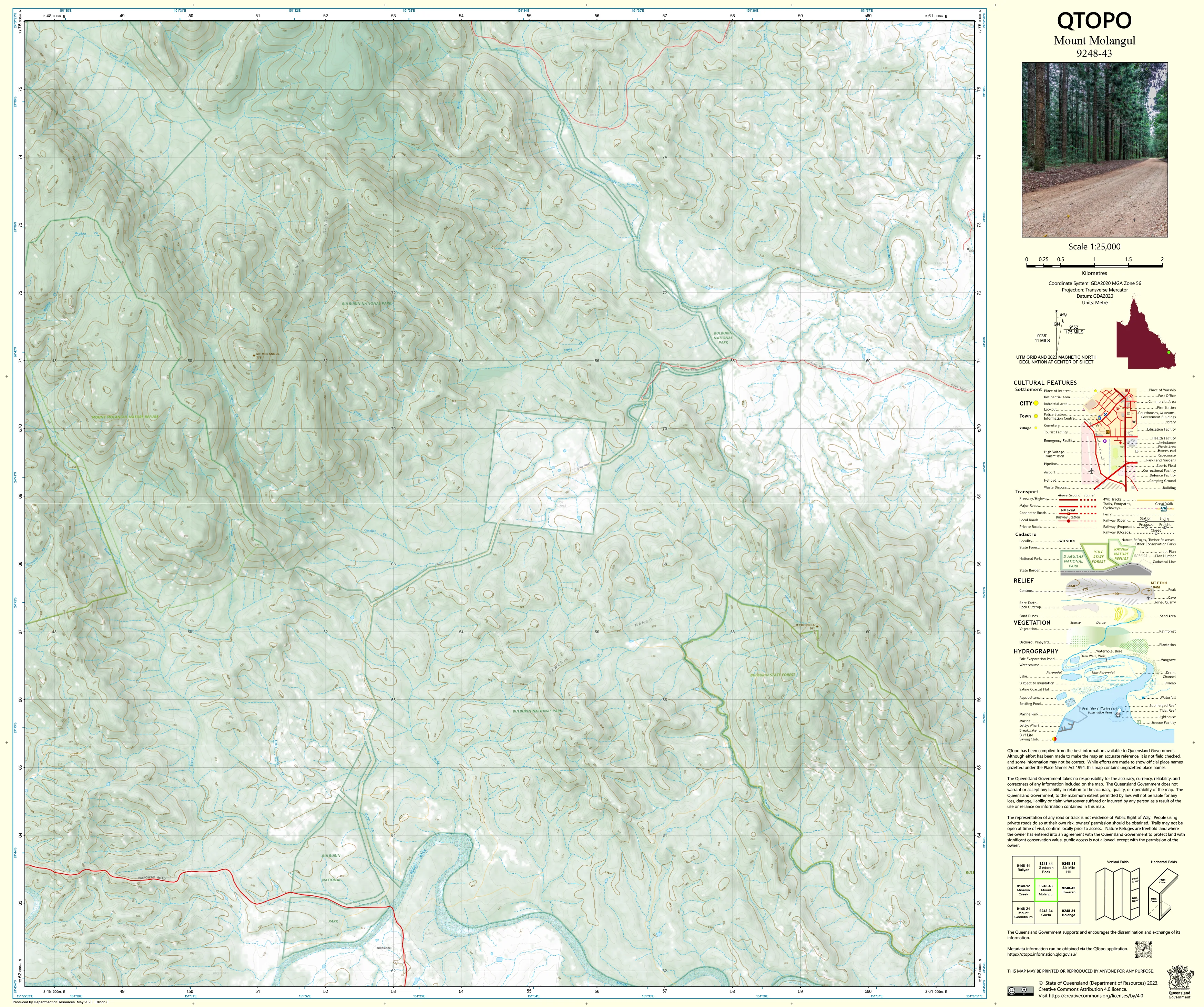
9248-43 Mount Molangul QTopo 1:25,000 Topographic Map
QTopo 9248-43 — Mount Molangul
1:25,000 Topographic Map
A high-precision topographic map covering the rugged Mount Molangul region—an area characterised by steep bush-covered ranges, deeply incised creek valleys, forested hill country, and remote rural landscapes between Monto and the Boyne Valley. The terrain here is varied and often challenging, making accurate mapping essential for safe navigation, land management, and field operations.
The QTopo 9248-43 (Mount Molangul) sheet—produced by the Queensland Department of Resources—is part of Queensland’s authoritative 1:25,000 topographic series. It provides detailed terrain modelling, hydrological mapping, infrastructure representation, and vegetation coverage across a region where forestry, grazing, and conservation values intersect.
Whether you’re undertaking environmental fieldwork, planning rural access, navigating steep tracks, or assessing landform conditions, QTopo 9248-43 gives you the clarity and precision needed to work effectively in this rugged landscape.
🗺️ Map Content and Features
At 1:25,000 scale—where 1 cm = 250 m—the map includes:
-
Contour lines revealing steep slopes, ridgelines, peaks, knolls, and rugged hill formations
-
Hydrology features: creek systems, drainage lines, waterholes, gullies, and seasonal channels
-
Roads, forestry tracks & 4WD routes used for land management, remote access, and exploration
-
Infrastructure including homesteads, sheds, fencelines, powerlines, and rural facilities
-
Vegetation mapping showing forest, woodland, scrub, open country, and riparian corridors
-
Land tenure boundaries: state forest areas, reserves, freehold land, and managed public land
-
Named natural features such as Mount Molangul, surrounding peaks, creek corridors, and distinctive high points
-
Points of interest for landholders, surveyors, ecologists, rangers, and emergency services
All QTopo sheets are built using Queensland’s authoritative spatial datasets, ensuring consistent, dependable accuracy.
🧭 Who Uses This Map?
The Mount Molangul 9248-43 Topographic Map is commonly used by:
-
Environmental scientists & ecologists – flora/fauna surveys, habitat mapping, biodiversity studies
-
Surveyors & planners – terrain analysis, boundary work, and infrastructure assessment
-
Graziers & land managers – paddock planning, water assessment, and property access
-
Forestry operators & rangers – track management, compartment mapping, operational planning
-
Emergency services & SES – fire response, flood modelling, and search & rescue coordination
-
4WD travellers & remote explorers – navigating steep, forested, and rugged terrain
A reliable reference for both professional and recreational field activity.
💧 Field-Ready Options for Rugged, Mountainous Terrain
Choose a print finish suited to Molangul’s steep slopes, dense bushland, and wet-season conditions.
✅ Waterproof & Tearproof Tyvek®
-
Printed on DuPont™ Tyvek®
-
Fully waterproof, tear-resistant, and lightweight
-
Ideal for rugged fieldwork, creek crossings, and repeated handling
✅ Laminated Edition
-
Encapsulated in 2 × 80-micron gloss laminate
-
Writeable surface for route planning and operational notes
-
Wipe-clean and resistant to mud, dust, moisture, and abrasion
📄 Standard Paper Edition
-
Crisp, high-quality printing
-
Suitable for planning, office reference, or occasional field use
📐 Map Details
Title: QTopo 9248-43 — Mount Molangul
Publisher: Queensland Department of Resources
Series: QTopo 1:25,000
Scale: 1:25,000 (1 cm = 250 m)
Dimensions: 710 mm (width) × 594 mm (height)
Coverage: Mount Molangul, surrounding hill country, creek systems, forestry areas, rural properties, and rugged backcountry terrain
Material Options: Paper, laminated, or waterproof Tyvek®
Printed in: Australia
Edition: Latest available (see listing for publication year)
📥 QTopo Map Index
Need adjoining Boyne Valley–Monto region mapping?
➡️ Share nearby sheet numbers—such as 9248-42, 9248-44, or 9348-33—and I’ll identify the adjoining maps instantly.
🛒 Ordering & Options
-
Standard folded paper map – ideal for planning and reference
-
Tyvek® waterproof edition – best for rugged, off-grid fieldwork
-
Laminated edition – durable, reusable, and suitable for operational planning
-
Flat (unfolded) maps available for wall or workshop display
🎯 Summary
The QTopo 9248-43 — Mount Molangul Topographic Map provides essential detail on terrain, hydrology, vegetation, access routes, and land use across one of Central Queensland’s most rugged and remote regions. With precise 1:25,000 mapping and robust printing options, it is indispensable for surveyors, ecologists, land managers, emergency crews, and serious 4WD explorers.
Plan with purpose.
Navigate with confidence.
Explore with clarity.
Choose your preferred finish today and take Mount Molangul into the field with Queensland’s most trusted topographic mapping.
Original: $14.27
-65%$14.27
$4.99Product Information
Product Information
Shipping & Returns
Shipping & Returns
Description
QTopo 9248-43 — Mount Molangul
1:25,000 Topographic Map
A high-precision topographic map covering the rugged Mount Molangul region—an area characterised by steep bush-covered ranges, deeply incised creek valleys, forested hill country, and remote rural landscapes between Monto and the Boyne Valley. The terrain here is varied and often challenging, making accurate mapping essential for safe navigation, land management, and field operations.
The QTopo 9248-43 (Mount Molangul) sheet—produced by the Queensland Department of Resources—is part of Queensland’s authoritative 1:25,000 topographic series. It provides detailed terrain modelling, hydrological mapping, infrastructure representation, and vegetation coverage across a region where forestry, grazing, and conservation values intersect.
Whether you’re undertaking environmental fieldwork, planning rural access, navigating steep tracks, or assessing landform conditions, QTopo 9248-43 gives you the clarity and precision needed to work effectively in this rugged landscape.
🗺️ Map Content and Features
At 1:25,000 scale—where 1 cm = 250 m—the map includes:
-
Contour lines revealing steep slopes, ridgelines, peaks, knolls, and rugged hill formations
-
Hydrology features: creek systems, drainage lines, waterholes, gullies, and seasonal channels
-
Roads, forestry tracks & 4WD routes used for land management, remote access, and exploration
-
Infrastructure including homesteads, sheds, fencelines, powerlines, and rural facilities
-
Vegetation mapping showing forest, woodland, scrub, open country, and riparian corridors
-
Land tenure boundaries: state forest areas, reserves, freehold land, and managed public land
-
Named natural features such as Mount Molangul, surrounding peaks, creek corridors, and distinctive high points
-
Points of interest for landholders, surveyors, ecologists, rangers, and emergency services
All QTopo sheets are built using Queensland’s authoritative spatial datasets, ensuring consistent, dependable accuracy.
🧭 Who Uses This Map?
The Mount Molangul 9248-43 Topographic Map is commonly used by:
-
Environmental scientists & ecologists – flora/fauna surveys, habitat mapping, biodiversity studies
-
Surveyors & planners – terrain analysis, boundary work, and infrastructure assessment
-
Graziers & land managers – paddock planning, water assessment, and property access
-
Forestry operators & rangers – track management, compartment mapping, operational planning
-
Emergency services & SES – fire response, flood modelling, and search & rescue coordination
-
4WD travellers & remote explorers – navigating steep, forested, and rugged terrain
A reliable reference for both professional and recreational field activity.
💧 Field-Ready Options for Rugged, Mountainous Terrain
Choose a print finish suited to Molangul’s steep slopes, dense bushland, and wet-season conditions.
✅ Waterproof & Tearproof Tyvek®
-
Printed on DuPont™ Tyvek®
-
Fully waterproof, tear-resistant, and lightweight
-
Ideal for rugged fieldwork, creek crossings, and repeated handling
✅ Laminated Edition
-
Encapsulated in 2 × 80-micron gloss laminate
-
Writeable surface for route planning and operational notes
-
Wipe-clean and resistant to mud, dust, moisture, and abrasion
📄 Standard Paper Edition
-
Crisp, high-quality printing
-
Suitable for planning, office reference, or occasional field use
📐 Map Details
Title: QTopo 9248-43 — Mount Molangul
Publisher: Queensland Department of Resources
Series: QTopo 1:25,000
Scale: 1:25,000 (1 cm = 250 m)
Dimensions: 710 mm (width) × 594 mm (height)
Coverage: Mount Molangul, surrounding hill country, creek systems, forestry areas, rural properties, and rugged backcountry terrain
Material Options: Paper, laminated, or waterproof Tyvek®
Printed in: Australia
Edition: Latest available (see listing for publication year)
📥 QTopo Map Index
Need adjoining Boyne Valley–Monto region mapping?
➡️ Share nearby sheet numbers—such as 9248-42, 9248-44, or 9348-33—and I’ll identify the adjoining maps instantly.
🛒 Ordering & Options
-
Standard folded paper map – ideal for planning and reference
-
Tyvek® waterproof edition – best for rugged, off-grid fieldwork
-
Laminated edition – durable, reusable, and suitable for operational planning
-
Flat (unfolded) maps available for wall or workshop display
🎯 Summary
The QTopo 9248-43 — Mount Molangul Topographic Map provides essential detail on terrain, hydrology, vegetation, access routes, and land use across one of Central Queensland’s most rugged and remote regions. With precise 1:25,000 mapping and robust printing options, it is indispensable for surveyors, ecologists, land managers, emergency crews, and serious 4WD explorers.
Plan with purpose.
Navigate with confidence.
Explore with clarity.
Choose your preferred finish today and take Mount Molangul into the field with Queensland’s most trusted topographic mapping.


