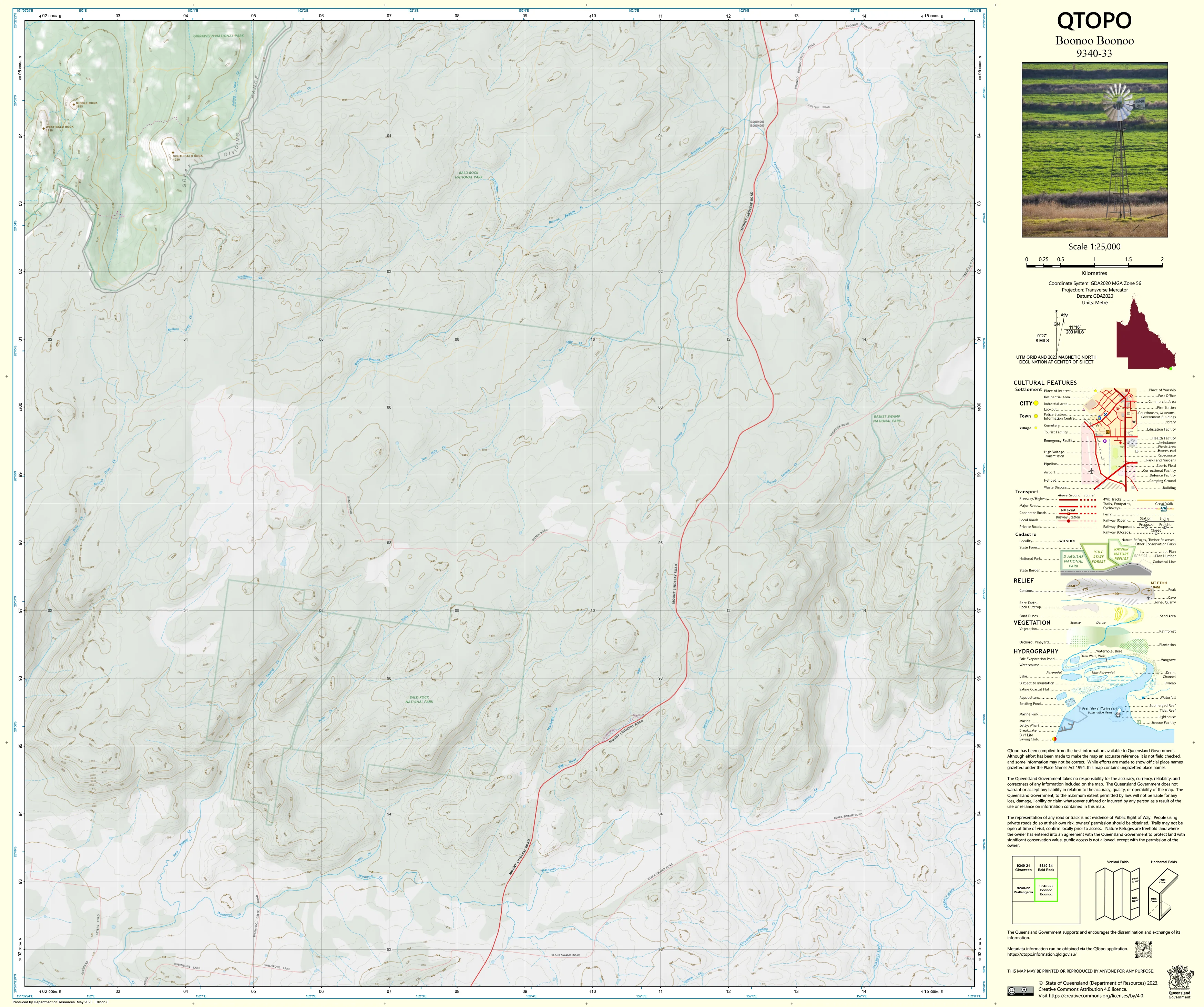
9340-33 Boonoo Boonoo QTopo 1:25,000 Topographic Map
QTopo 9340-33 — Boonoo Boonoo
1:25,000 Topographic Map
A high-resolution topographic map covering the spectacular Boonoo Boonoo region—an area renowned for its dramatic granite outcrops, deep river gorges, forested high country, and wild, rugged landscapes along the Queensland–New South Wales border. Home to winding creeks, national park terrain, waterfalls, and remote ridgelines, Boonoo Boonoo is a place where accurate navigation is essential.
The QTopo 9340-33 (Boonoo Boonoo) sheet—produced by the Queensland Department of Resources—forms part of Queensland’s authoritative 1:25,000 topographic mapping series. It provides finely detailed terrain modelling, hydrology mapping, vegetation structure, and access information across one of the most iconic granite regions in the region.
Whether you're bushwalking, conducting conservation work, surveying remote land, or exploring rugged ridges and river corridors, QTopo 9340-33 delivers the precision and reliability needed for confident decision-making.
🗺️ Map Content and Features
At 1:25,000 scale—where 1 cm = 250 m—this map includes:
-
Contour lines showing steep escarpments, bouldered hills, ridges, tors, cliffs, and deep granite valleys
-
Hydrology features: Boonoo Boonoo River, creeks, tributaries, waterfalls, cascades, and drainage systems
-
Walking tracks, 4WD routes & remote access trails across national park and adjoining rural land
-
Infrastructure including roads, trailheads, fence lines, visitor facilities, and rural structures
-
Vegetation mapping showing forest, woodland, heathland, scrub, and riparian vegetation
-
Land tenure boundaries: national park, conservation estate, state land, and freehold parcels
-
Named natural features such as Boonoo Boonoo River, waterfalls, mountain peaks, ridges, and granite domes
-
Points of interest for bushwalkers, ecologists, rangers, surveyors, and emergency services
All QTopo maps are based on Queensland’s authoritative spatial datasets, ensuring consistent and dependable accuracy.
🧭 Who Uses This Map?
The Boonoo Boonoo 9340-33 Topographic Map is commonly used by:
-
Bushwalkers & hikers – navigating rugged trails, river corridors, and granite outcrops
-
Environmental scientists & ecologists – habitat surveys, catchment studies, and biodiversity work
-
Surveyors & planners – detailed terrain interpretation and boundary assessment
-
Rangers & conservation staff – managing protected areas and monitoring ecosystems
-
Emergency services & SES – search & rescue, fire planning, and remote response
-
4WD adventurers & backcountry explorers – travelling remote ridgelines and access tracks
-
Outdoor educators – teaching advanced navigation in complex granite environments
A trusted reference for both professional and recreational exploration.
💧 Field-Ready Options for Rugged Granite Country
Choose a print finish suited to the steep, wet-season-prone, and rocky terrain of the Boonoo Boonoo region.
✅ Waterproof & Tearproof Tyvek®
-
Printed on DuPont™ Tyvek®
-
Completely waterproof, tear-resistant, lightweight, and highly durable
-
Ideal for wet conditions, creek crossings, and rugged handling
✅ Laminated Edition
-
Encapsulated in 2 × 80-micron gloss laminate
-
Writeable surface for route planning and notes
-
Wipe-clean and resistant to mud, moisture, and repeated usage
📄 Standard Paper Edition
-
Crisp, detailed printing
-
Ideal for planning, desk reference, or occasional outdoor use
📐 Map Details
Title: QTopo 9340-33 — Boonoo Boonoo
Publisher: Queensland Department of Resources
Series: QTopo 1:25,000
Scale: 1:25,000 (1 cm = 250 m)
Dimensions: 710 mm (width) × 594 mm (height)
Coverage: Boonoo Boonoo River, granite ridges, national park terrain, waterfalls, escarpments, and adjoining rural land
Material Options: Paper, laminated, or waterproof Tyvek®
Printed in: Australia
Edition: Latest available (see listing for publication year)
📥 QTopo Map Index
Need neighbouring coverage for the full granite belt region?
➡️ Share adjacent sheet numbers—such as 9340-23, 9340-34, or 9240-31—and I’ll locate the matching maps instantly.
🛒 Ordering & Options
-
Standard folded paper map – ideal for planning and reference
-
Tyvek® waterproof edition – ideal for all-weather, rugged field exploration
-
Laminated edition – durable, reusable, and great for operational use
-
Flat (unfolded) maps available for wall or workspace display
🎯 Summary
The QTopo 9340-33 — Boonoo Boonoo Topographic Map delivers finely detailed terrain, hydrology, vegetation, access, and land-use information across one of the most striking and rugged granite landscapes on the Queensland–NSW border. With precise 1:25,000 mapping and field-tough print options, it is essential for surveyors, ecologists, rangers, land managers, bushwalkers, and serious remote-area explorers.
Plan with purpose.
Navigate with confidence.
Explore with accuracy.
Choose your preferred finish today and carry Boonoo Boonoo into the field with Queensland’s most trusted topographic mapping.
Product Information
Product Information
Shipping & Returns
Shipping & Returns
Description
QTopo 9340-33 — Boonoo Boonoo
1:25,000 Topographic Map
A high-resolution topographic map covering the spectacular Boonoo Boonoo region—an area renowned for its dramatic granite outcrops, deep river gorges, forested high country, and wild, rugged landscapes along the Queensland–New South Wales border. Home to winding creeks, national park terrain, waterfalls, and remote ridgelines, Boonoo Boonoo is a place where accurate navigation is essential.
The QTopo 9340-33 (Boonoo Boonoo) sheet—produced by the Queensland Department of Resources—forms part of Queensland’s authoritative 1:25,000 topographic mapping series. It provides finely detailed terrain modelling, hydrology mapping, vegetation structure, and access information across one of the most iconic granite regions in the region.
Whether you're bushwalking, conducting conservation work, surveying remote land, or exploring rugged ridges and river corridors, QTopo 9340-33 delivers the precision and reliability needed for confident decision-making.
🗺️ Map Content and Features
At 1:25,000 scale—where 1 cm = 250 m—this map includes:
-
Contour lines showing steep escarpments, bouldered hills, ridges, tors, cliffs, and deep granite valleys
-
Hydrology features: Boonoo Boonoo River, creeks, tributaries, waterfalls, cascades, and drainage systems
-
Walking tracks, 4WD routes & remote access trails across national park and adjoining rural land
-
Infrastructure including roads, trailheads, fence lines, visitor facilities, and rural structures
-
Vegetation mapping showing forest, woodland, heathland, scrub, and riparian vegetation
-
Land tenure boundaries: national park, conservation estate, state land, and freehold parcels
-
Named natural features such as Boonoo Boonoo River, waterfalls, mountain peaks, ridges, and granite domes
-
Points of interest for bushwalkers, ecologists, rangers, surveyors, and emergency services
All QTopo maps are based on Queensland’s authoritative spatial datasets, ensuring consistent and dependable accuracy.
🧭 Who Uses This Map?
The Boonoo Boonoo 9340-33 Topographic Map is commonly used by:
-
Bushwalkers & hikers – navigating rugged trails, river corridors, and granite outcrops
-
Environmental scientists & ecologists – habitat surveys, catchment studies, and biodiversity work
-
Surveyors & planners – detailed terrain interpretation and boundary assessment
-
Rangers & conservation staff – managing protected areas and monitoring ecosystems
-
Emergency services & SES – search & rescue, fire planning, and remote response
-
4WD adventurers & backcountry explorers – travelling remote ridgelines and access tracks
-
Outdoor educators – teaching advanced navigation in complex granite environments
A trusted reference for both professional and recreational exploration.
💧 Field-Ready Options for Rugged Granite Country
Choose a print finish suited to the steep, wet-season-prone, and rocky terrain of the Boonoo Boonoo region.
✅ Waterproof & Tearproof Tyvek®
-
Printed on DuPont™ Tyvek®
-
Completely waterproof, tear-resistant, lightweight, and highly durable
-
Ideal for wet conditions, creek crossings, and rugged handling
✅ Laminated Edition
-
Encapsulated in 2 × 80-micron gloss laminate
-
Writeable surface for route planning and notes
-
Wipe-clean and resistant to mud, moisture, and repeated usage
📄 Standard Paper Edition
-
Crisp, detailed printing
-
Ideal for planning, desk reference, or occasional outdoor use
📐 Map Details
Title: QTopo 9340-33 — Boonoo Boonoo
Publisher: Queensland Department of Resources
Series: QTopo 1:25,000
Scale: 1:25,000 (1 cm = 250 m)
Dimensions: 710 mm (width) × 594 mm (height)
Coverage: Boonoo Boonoo River, granite ridges, national park terrain, waterfalls, escarpments, and adjoining rural land
Material Options: Paper, laminated, or waterproof Tyvek®
Printed in: Australia
Edition: Latest available (see listing for publication year)
📥 QTopo Map Index
Need neighbouring coverage for the full granite belt region?
➡️ Share adjacent sheet numbers—such as 9340-23, 9340-34, or 9240-31—and I’ll locate the matching maps instantly.
🛒 Ordering & Options
-
Standard folded paper map – ideal for planning and reference
-
Tyvek® waterproof edition – ideal for all-weather, rugged field exploration
-
Laminated edition – durable, reusable, and great for operational use
-
Flat (unfolded) maps available for wall or workspace display
🎯 Summary
The QTopo 9340-33 — Boonoo Boonoo Topographic Map delivers finely detailed terrain, hydrology, vegetation, access, and land-use information across one of the most striking and rugged granite landscapes on the Queensland–NSW border. With precise 1:25,000 mapping and field-tough print options, it is essential for surveyors, ecologists, rangers, land managers, bushwalkers, and serious remote-area explorers.
Plan with purpose.
Navigate with confidence.
Explore with accuracy.
Choose your preferred finish today and carry Boonoo Boonoo into the field with Queensland’s most trusted topographic mapping.


