9340-34 Bald Rock QTopo 1:25,000 Topographic Map
QTopo 9340-34 — Bald Rock
1:25,000 Topographic Map
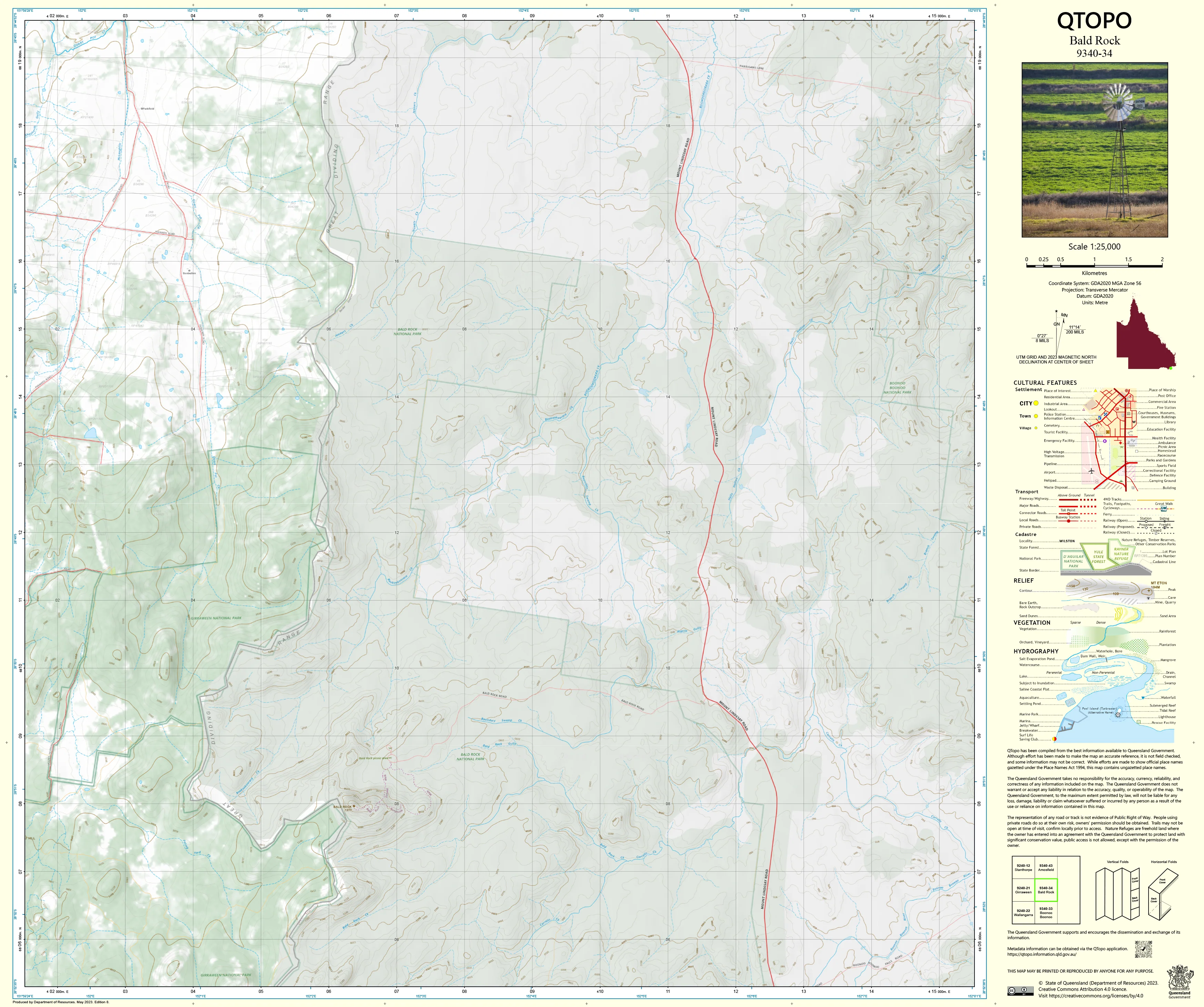
A high-accuracy topographic map covering the iconic Bald Rock region—home to some of the most spectacular granite landscapes on the Queensland–New South Wales border. Dominated by vast granite domes, boulder fields, forested slopes, and deeply cut creek systems, this area demands precise navigation and reliable topographic detail.
The QTopo 9340-34 (Bald Rock) sheet—created by the Queensland Department of Resources—is part of the authoritative 1:25,000 mapping series. It delivers finely detailed terrain representation, hydrological mapping, vegetation structure, and access information across one of the Granite Belt’s most dramatic environments.
Whether you're hiking between granite peaks, conducting ecological surveys, mapping watershed behaviour, or navigating remote bushland, QTopo 9340-34 provides the accuracy and clarity required for confident fieldwork.
🗺️ Map Content and Features
At 1:25,000 scale—where 1 cm = 250 m—this map includes:
-
Contour lines capturing Bald Rock’s steep domes, tors, slopes, granite sheets, bouldered hills, and deep valleys
-
Hydrology features: creeks, tributaries, drainage lines, rock holes, and seasonal runoff channels
-
Walking tracks, 4WD routes & access paths through national park terrain and surrounding bushland
-
Infrastructure including roads, trailheads, visitor areas, fence lines, power corridors, and rural structures
-
Vegetation mapping showing eucalypt forest, woodland, granite heathland, scrub, and riparian zones
-
Land tenure boundaries: national park, conservation estate, state land, and adjoining freehold parcels
-
Named natural features such as Bald Rock, granite domes, creek corridors, ridges, and peaks
-
Points of interest relevant to rangers, ecologists, hikers, and surveyors
All QTopo maps use Queensland’s authoritative spatial datasets for consistent, dependable accuracy.
🧭 Who Uses This Map?
The Bald Rock 9340-34 Topographic Map is widely used by:
-
Bushwalkers & hikers – navigating granite domes, summit routes, and forested ridges
-
Environmental scientists & ecologists – biodiversity studies, habitat mapping, fire ecology work
-
Surveyors & planners – terrain modelling, boundary work, and environmental assessment
-
Rangers & conservation staff – managing protected areas and monitoring sensitive ecosystems
-
Emergency services & SES – search & rescue, bushfire response, and rugged-terrain operations
-
4WD travellers & backcountry explorers – accessing isolated ridgelines and remote tracks
-
Outdoor educators – teaching advanced navigation in complex, rocky landscapes
A trusted resource for both professional and recreational exploration.
💧 Field-Ready Options for Granite Belt Conditions
Choose a finish tailored to the wet-season weather, rugged rock formations, and exposed conditions typical of the Bald Rock region.
✅ Waterproof & Tearproof Tyvek®
-
Printed on DuPont™ Tyvek®
-
Fully waterproof, tear-resistant, lightweight, and durable
-
Ideal for repeated use in all-weather conditions and rugged terrain
✅ Laminated Edition
-
Encapsulated in 2 × 80-micron gloss laminate
-
Writeable surface suitable for whiteboard markers
-
Wipe-clean and resistant to moisture, mud, dust, and abrasion
📄 Standard Paper Edition
-
Crisp, high-resolution printing
-
Suitable for planning, reference, and occasional fieldwork
📐 Map Details
Title: QTopo 9340-34 — Bald Rock
Publisher: Queensland Department of Resources
Series: QTopo 1:25,000
Scale: 1:25,000 (1 cm = 250 m)
Dimensions: 710 mm (width) × 594 mm (height)
Coverage: Bald Rock, granite domes, national park terrain, creek systems, forested ridgelines, and adjoining rural areas
Material Options: Paper, laminated, or waterproof Tyvek®
Printed in: Australia
Edition: Latest available (see listing for publication year)
📥 QTopo Map Index
Need coverage for the full Granite Belt area?
➡️ Share adjacent sheet numbers—such as 9340-23, 9340-33, or 9240-32—and I’ll locate the adjoining maps instantly.
🛒 Ordering & Options
-
Standard folded paper map – ideal for planning and desk reference
-
Tyvek® waterproof edition – built for all-weather fieldwork in rugged country
-
Laminated edition – durable, reusable, and suitable for operational or educational use
-
Flat (unfolded) maps available for wall or workspace display
🎯 Summary
The QTopo 9340-34 — Bald Rock Topographic Map provides essential detail on terrain, hydrology, vegetation, access, and land use across one of the most striking granite environments on the Queensland–NSW border. With precise 1:25,000 mapping and robust print options, it is indispensable for surveyors, ecologists, land managers, rangers, hikers, and serious remote-area explorers.
Plan with purpose.
Navigate with confidence.
Explore with accuracy.
Choose your preferred finish today and take Bald Rock into the field with Queensland’s most trusted topographic mapping.
Product Information
Product Information
Shipping & Returns
Shipping & Returns
Description
QTopo 9340-34 — Bald Rock
1:25,000 Topographic Map
A high-accuracy topographic map covering the iconic Bald Rock region—home to some of the most spectacular granite landscapes on the Queensland–New South Wales border. Dominated by vast granite domes, boulder fields, forested slopes, and deeply cut creek systems, this area demands precise navigation and reliable topographic detail.
The QTopo 9340-34 (Bald Rock) sheet—created by the Queensland Department of Resources—is part of the authoritative 1:25,000 mapping series. It delivers finely detailed terrain representation, hydrological mapping, vegetation structure, and access information across one of the Granite Belt’s most dramatic environments.
Whether you're hiking between granite peaks, conducting ecological surveys, mapping watershed behaviour, or navigating remote bushland, QTopo 9340-34 provides the accuracy and clarity required for confident fieldwork.
🗺️ Map Content and Features
At 1:25,000 scale—where 1 cm = 250 m—this map includes:
-
Contour lines capturing Bald Rock’s steep domes, tors, slopes, granite sheets, bouldered hills, and deep valleys
-
Hydrology features: creeks, tributaries, drainage lines, rock holes, and seasonal runoff channels
-
Walking tracks, 4WD routes & access paths through national park terrain and surrounding bushland
-
Infrastructure including roads, trailheads, visitor areas, fence lines, power corridors, and rural structures
-
Vegetation mapping showing eucalypt forest, woodland, granite heathland, scrub, and riparian zones
-
Land tenure boundaries: national park, conservation estate, state land, and adjoining freehold parcels
-
Named natural features such as Bald Rock, granite domes, creek corridors, ridges, and peaks
-
Points of interest relevant to rangers, ecologists, hikers, and surveyors
All QTopo maps use Queensland’s authoritative spatial datasets for consistent, dependable accuracy.
🧭 Who Uses This Map?
The Bald Rock 9340-34 Topographic Map is widely used by:
-
Bushwalkers & hikers – navigating granite domes, summit routes, and forested ridges
-
Environmental scientists & ecologists – biodiversity studies, habitat mapping, fire ecology work
-
Surveyors & planners – terrain modelling, boundary work, and environmental assessment
-
Rangers & conservation staff – managing protected areas and monitoring sensitive ecosystems
-
Emergency services & SES – search & rescue, bushfire response, and rugged-terrain operations
-
4WD travellers & backcountry explorers – accessing isolated ridgelines and remote tracks
-
Outdoor educators – teaching advanced navigation in complex, rocky landscapes
A trusted resource for both professional and recreational exploration.
💧 Field-Ready Options for Granite Belt Conditions
Choose a finish tailored to the wet-season weather, rugged rock formations, and exposed conditions typical of the Bald Rock region.
✅ Waterproof & Tearproof Tyvek®
-
Printed on DuPont™ Tyvek®
-
Fully waterproof, tear-resistant, lightweight, and durable
-
Ideal for repeated use in all-weather conditions and rugged terrain
✅ Laminated Edition
-
Encapsulated in 2 × 80-micron gloss laminate
-
Writeable surface suitable for whiteboard markers
-
Wipe-clean and resistant to moisture, mud, dust, and abrasion
📄 Standard Paper Edition
-
Crisp, high-resolution printing
-
Suitable for planning, reference, and occasional fieldwork
📐 Map Details
Title: QTopo 9340-34 — Bald Rock
Publisher: Queensland Department of Resources
Series: QTopo 1:25,000
Scale: 1:25,000 (1 cm = 250 m)
Dimensions: 710 mm (width) × 594 mm (height)
Coverage: Bald Rock, granite domes, national park terrain, creek systems, forested ridgelines, and adjoining rural areas
Material Options: Paper, laminated, or waterproof Tyvek®
Printed in: Australia
Edition: Latest available (see listing for publication year)
📥 QTopo Map Index
Need coverage for the full Granite Belt area?
➡️ Share adjacent sheet numbers—such as 9340-23, 9340-33, or 9240-32—and I’ll locate the adjoining maps instantly.
🛒 Ordering & Options
-
Standard folded paper map – ideal for planning and desk reference
-
Tyvek® waterproof edition – built for all-weather fieldwork in rugged country
-
Laminated edition – durable, reusable, and suitable for operational or educational use
-
Flat (unfolded) maps available for wall or workspace display
🎯 Summary
The QTopo 9340-34 — Bald Rock Topographic Map provides essential detail on terrain, hydrology, vegetation, access, and land use across one of the most striking granite environments on the Queensland–NSW border. With precise 1:25,000 mapping and robust print options, it is indispensable for surveyors, ecologists, land managers, rangers, hikers, and serious remote-area explorers.
Plan with purpose.
Navigate with confidence.
Explore with accuracy.
Choose your preferred finish today and take Bald Rock into the field with Queensland’s most trusted topographic mapping.


