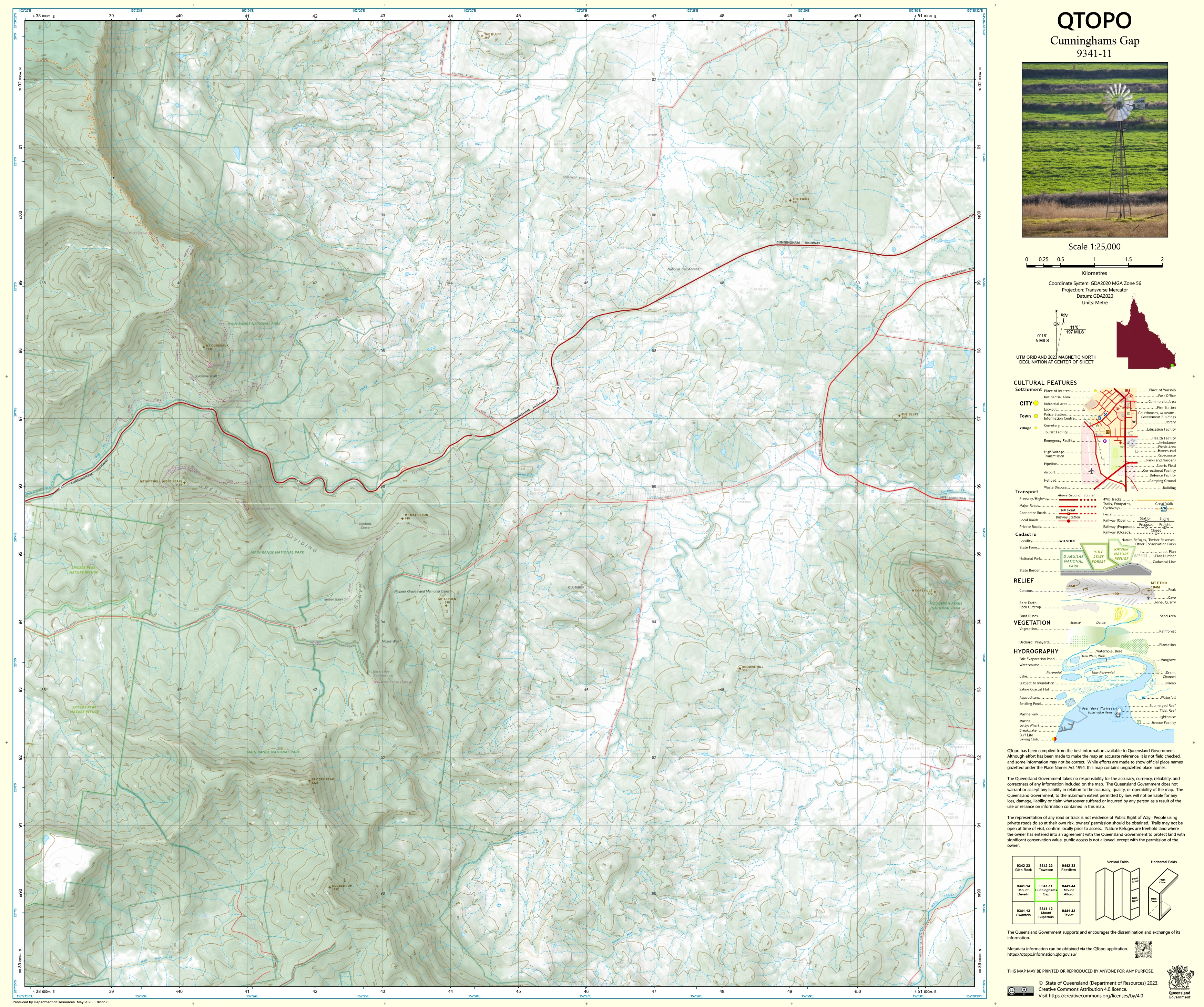
9341-11 Cunninghams Gap QTopo 1:25,000 Topographic Map
QTopo 9341-11 — Cunninghams Gap
1:25,000 Topographic Map
A high-accuracy topographic map covering the dramatic Cunninghams Gap region—where the Cunningham Highway cuts through the steep, forested slopes of the Great Dividing Range. This area is dominated by deep valleys, volcanic peaks, high escarpments, rainforest-covered ridges, and rugged national park terrain, making reliable mapping essential for safe navigation and professional fieldwork.
The QTopo 9341-11 (Cunninghams Gap) sheet—produced by the Queensland Department of Resources—forms part of the authoritative 1:25,000 mapping series. It provides detailed elevation modelling, hydrology mapping, vegetation structure, infrastructure layout, and access information across one of Southeast Queensland’s most iconic mountain passes.
Whether you're hiking the Main Range tracks, conducting ecological surveys, managing national park assets, or assessing steep-slope terrain, QTopo 9341-11 delivers the precision and clarity required for confident navigation and planning.
🗺️ Map Content and Features
At 1:25,000 scale—where 1 cm = 250 m—this map includes:
-
Contour lines showing steep escarpments, volcanic peaks, ridgelines, cliffs, knolls, and deep forested valleys
-
Hydrology features: creeks, waterfalls, tributaries, drainage lines, and upper catchment systems
-
Walking tracks & access routes throughout Main Range National Park, including summit trails and ridge traverses
-
Infrastructure such as the Cunningham Highway, lookouts, picnic areas, car parks, facilities, fencelines, and powerlines
-
Vegetation mapping showing rainforest, wet sclerophyll forest, woodland, montane scrub, and riparian vegetation
-
Land tenure boundaries: national park, state land, conservation areas, and neighbouring freehold land
-
Named features including Mount Cordeaux, Mount Mitchell, Bare Rock, Gap Creek, and iconic viewpoints
-
Points of interest for hikers, ecologists, rangers, surveyors, and emergency responders
All QTopo maps draw from Queensland’s authoritative spatial datasets, ensuring consistent, reliable accuracy.
🧭 Who Uses This Map?
The Cunninghams Gap 9341-11 Topographic Map is widely used by:
-
Hikers & bushwalkers – navigating steep summit trails and rainforest tracks
-
Environmental scientists & ecologists – flora/fauna surveys, catchment analysis, fire ecology work
-
Rangers & conservation staff – managing protected areas and maintaining track networks
-
Surveyors & planners – steep-slope assessment, infrastructure planning, boundary evaluation
-
Emergency services & SES – search & rescue, bushfire response, and rugged-terrain operations
-
4WD travellers & explorers – accessing surrounding ridge roads and backcountry areas
-
Outdoor educators – teaching navigation in mountainous environments
A trusted tool for both professional and recreational users.
💧 Field-Ready Options for Mountainous, High-Rainfall Conditions
Choose a print finish built for the wet seasons, steep slopes, and dense vegetation typical of the Main Range.
✅ Waterproof & Tearproof Tyvek®
-
Printed on DuPont™ Tyvek®
-
Completely waterproof, tear-resistant, lightweight, and robust
-
Ideal for creek crossings, summit routes, and repeated field handling
✅ Laminated Edition
-
Encapsulated in 2 × 80-micron gloss laminate
-
Writeable surface for route planning or teaching
-
Wipe-clean and resistant to moisture, mud, dust, and abrasion
📄 Standard Paper Edition
-
Crisp, high-resolution print
-
Best for planning, office use, and occasional field reference
📐 Map Details
Title: QTopo 9341-11 — Cunninghams Gap
Publisher: Queensland Department of Resources
Series: QTopo 1:25,000
Scale: 1:25,000 (1 cm = 250 m)
Dimensions: 710 mm (width) × 594 mm (height)
Coverage: Cunninghams Gap, Main Range National Park, Mount Cordeaux, Mount Mitchell, ridge systems, creek catchments, and surrounding rural land
Material Options: Paper, laminated, or waterproof Tyvek®
Printed in: Australia
Edition: Latest available (see listing for publication year)
📥 QTopo Map Index
Need adjoining Main Range or Scenic Rim coverage?
➡️ Provide nearby sheet numbers—such as 9341-12, 9241-23, or 9441-02—and I’ll locate the adjoining maps instantly.
🛒 Ordering & Options
-
Standard folded paper map – ideal for planning and reference
-
Tyvek® waterproof edition – the best choice for rugged, wet, mountaintop fieldwork
-
Laminated edition – durable, reusable, and excellent for operational planning
-
Flat (unfolded) maps available for wall, classroom, or workshop display
🎯 Summary
The QTopo 9341-11 — Cunninghams Gap Topographic Map provides essential detail on terrain, hydrology, vegetation, access, and land use across one of Southeast Queensland’s most iconic and rugged national park landscapes. With precise 1:25,000 mapping and field-tough printing options, it is indispensable for hikers, ecologists, rangers, surveyors, emergency crews, and serious outdoor explorers.
Plan with purpose.
Navigate with confidence.
Explore with accuracy.
Choose your preferred finish today and take Cunninghams Gap into the field with Queensland’s most trusted topographic mapping.
Original: $14.27
-65%$14.27
$4.99Product Information
Product Information
Shipping & Returns
Shipping & Returns
Description
QTopo 9341-11 — Cunninghams Gap
1:25,000 Topographic Map
A high-accuracy topographic map covering the dramatic Cunninghams Gap region—where the Cunningham Highway cuts through the steep, forested slopes of the Great Dividing Range. This area is dominated by deep valleys, volcanic peaks, high escarpments, rainforest-covered ridges, and rugged national park terrain, making reliable mapping essential for safe navigation and professional fieldwork.
The QTopo 9341-11 (Cunninghams Gap) sheet—produced by the Queensland Department of Resources—forms part of the authoritative 1:25,000 mapping series. It provides detailed elevation modelling, hydrology mapping, vegetation structure, infrastructure layout, and access information across one of Southeast Queensland’s most iconic mountain passes.
Whether you're hiking the Main Range tracks, conducting ecological surveys, managing national park assets, or assessing steep-slope terrain, QTopo 9341-11 delivers the precision and clarity required for confident navigation and planning.
🗺️ Map Content and Features
At 1:25,000 scale—where 1 cm = 250 m—this map includes:
-
Contour lines showing steep escarpments, volcanic peaks, ridgelines, cliffs, knolls, and deep forested valleys
-
Hydrology features: creeks, waterfalls, tributaries, drainage lines, and upper catchment systems
-
Walking tracks & access routes throughout Main Range National Park, including summit trails and ridge traverses
-
Infrastructure such as the Cunningham Highway, lookouts, picnic areas, car parks, facilities, fencelines, and powerlines
-
Vegetation mapping showing rainforest, wet sclerophyll forest, woodland, montane scrub, and riparian vegetation
-
Land tenure boundaries: national park, state land, conservation areas, and neighbouring freehold land
-
Named features including Mount Cordeaux, Mount Mitchell, Bare Rock, Gap Creek, and iconic viewpoints
-
Points of interest for hikers, ecologists, rangers, surveyors, and emergency responders
All QTopo maps draw from Queensland’s authoritative spatial datasets, ensuring consistent, reliable accuracy.
🧭 Who Uses This Map?
The Cunninghams Gap 9341-11 Topographic Map is widely used by:
-
Hikers & bushwalkers – navigating steep summit trails and rainforest tracks
-
Environmental scientists & ecologists – flora/fauna surveys, catchment analysis, fire ecology work
-
Rangers & conservation staff – managing protected areas and maintaining track networks
-
Surveyors & planners – steep-slope assessment, infrastructure planning, boundary evaluation
-
Emergency services & SES – search & rescue, bushfire response, and rugged-terrain operations
-
4WD travellers & explorers – accessing surrounding ridge roads and backcountry areas
-
Outdoor educators – teaching navigation in mountainous environments
A trusted tool for both professional and recreational users.
💧 Field-Ready Options for Mountainous, High-Rainfall Conditions
Choose a print finish built for the wet seasons, steep slopes, and dense vegetation typical of the Main Range.
✅ Waterproof & Tearproof Tyvek®
-
Printed on DuPont™ Tyvek®
-
Completely waterproof, tear-resistant, lightweight, and robust
-
Ideal for creek crossings, summit routes, and repeated field handling
✅ Laminated Edition
-
Encapsulated in 2 × 80-micron gloss laminate
-
Writeable surface for route planning or teaching
-
Wipe-clean and resistant to moisture, mud, dust, and abrasion
📄 Standard Paper Edition
-
Crisp, high-resolution print
-
Best for planning, office use, and occasional field reference
📐 Map Details
Title: QTopo 9341-11 — Cunninghams Gap
Publisher: Queensland Department of Resources
Series: QTopo 1:25,000
Scale: 1:25,000 (1 cm = 250 m)
Dimensions: 710 mm (width) × 594 mm (height)
Coverage: Cunninghams Gap, Main Range National Park, Mount Cordeaux, Mount Mitchell, ridge systems, creek catchments, and surrounding rural land
Material Options: Paper, laminated, or waterproof Tyvek®
Printed in: Australia
Edition: Latest available (see listing for publication year)
📥 QTopo Map Index
Need adjoining Main Range or Scenic Rim coverage?
➡️ Provide nearby sheet numbers—such as 9341-12, 9241-23, or 9441-02—and I’ll locate the adjoining maps instantly.
🛒 Ordering & Options
-
Standard folded paper map – ideal for planning and reference
-
Tyvek® waterproof edition – the best choice for rugged, wet, mountaintop fieldwork
-
Laminated edition – durable, reusable, and excellent for operational planning
-
Flat (unfolded) maps available for wall, classroom, or workshop display
🎯 Summary
The QTopo 9341-11 — Cunninghams Gap Topographic Map provides essential detail on terrain, hydrology, vegetation, access, and land use across one of Southeast Queensland’s most iconic and rugged national park landscapes. With precise 1:25,000 mapping and field-tough printing options, it is indispensable for hikers, ecologists, rangers, surveyors, emergency crews, and serious outdoor explorers.
Plan with purpose.
Navigate with confidence.
Explore with accuracy.
Choose your preferred finish today and take Cunninghams Gap into the field with Queensland’s most trusted topographic mapping.


