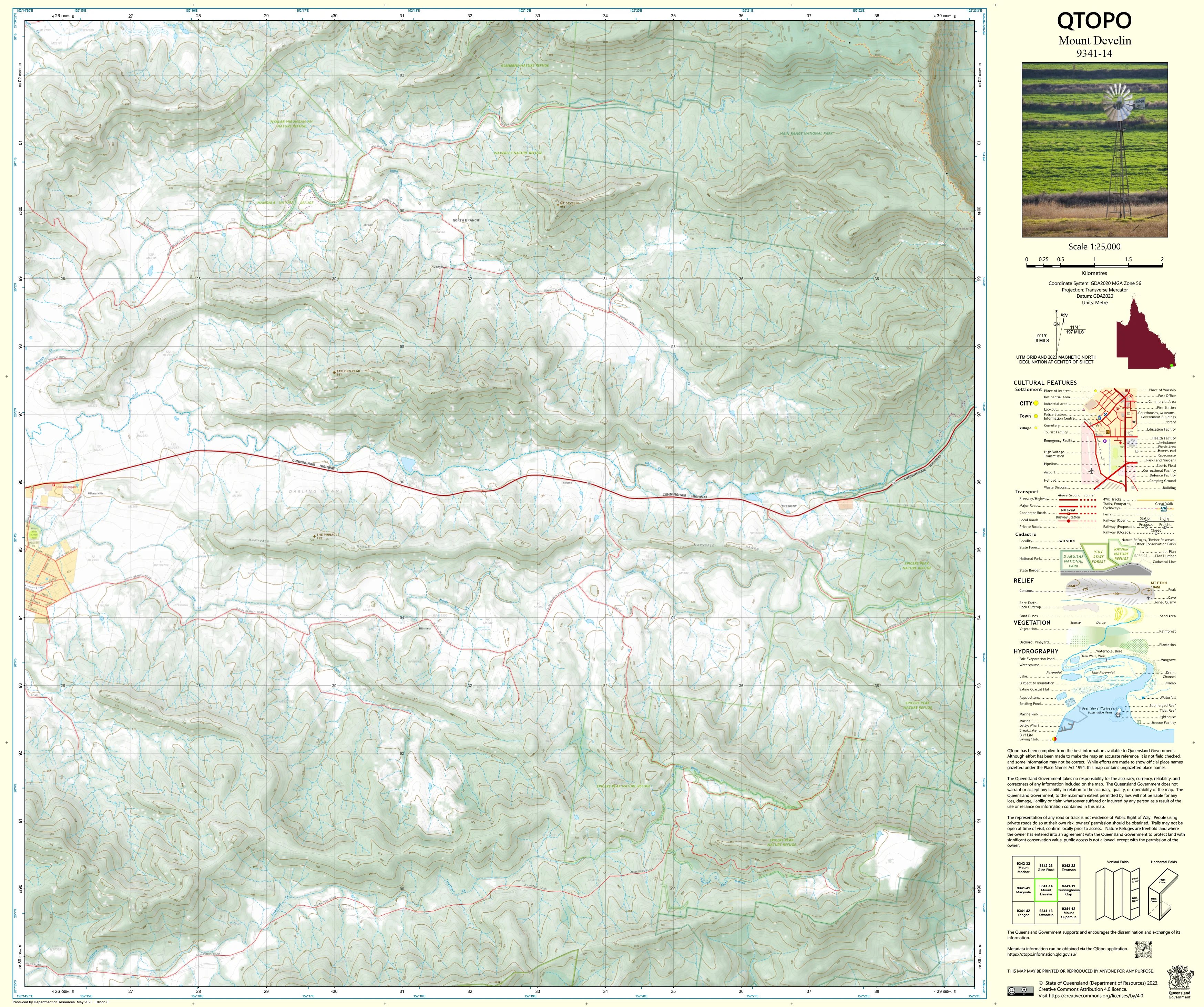
9341-14 Mount Develin QTopo 1:25,000 Topographic Map
QTopo 9341-14 — Mount Develin
1:25,000 Topographic Map
A precise, high-resolution topographic map covering the rugged Mount Develin region—an area of steep ridgelines, densely forested slopes, deep creek valleys, and remote wilderness terrain on the western side of the Scenic Rim. With its volcanic landforms, narrow spurs, and complex drainage systems, Mount Develin demands accurate navigation and reliable mapping for safe travel and effective fieldwork.
The QTopo 9341-14 (Mount Develin) sheet—produced by the Queensland Department of Resources—is part of the state’s authoritative 1:25,000 topographic mapping series. It provides detailed terrain representation, hydrology mapping, vegetation structure, and access information across one of South-East Queensland’s lesser-known but technically challenging mountainous areas.
Whether you’re conducting environmental surveys, navigating remote tracks, assessing steep terrain, or exploring the high-country wilderness, QTopo 9341-14 delivers the clarity and precision needed to make informed decisions in the field.
🗺️ Map Content and Features
At 1:25,000 scale—where 1 cm = 250 m—this map includes:
-
Contour lines defining steep volcanic peaks, ridgelines, escarpments, gullies, cliffs, and narrow spurs
-
Hydrology features including creeks, tributaries, waterfalls, drainage networks, and upper catchment systems
-
Remote walking tracks & access routes used by bushwalkers, researchers, and park rangers
-
Infrastructure such as boundary fences, access roads, fire trails, and communication installations
-
Vegetation mapping covering rainforest pockets, wet sclerophyll forest, woodland, scrub, and riparian zones
-
Land tenure boundaries: national park, state land, conservation parks, and neighbouring freehold land
-
Named natural features including Mount Develin, peak formations, creek corridors, and distinctive ridge systems
-
Points of interest for ecologists, rangers, surveyors, and experienced explorers
All QTopo maps are compiled from Queensland’s authoritative spatial datasets for dependable consistency and accuracy.
🧭 Who Uses This Map?
The Mount Develin 9341-14 Topographic Map is widely used by:
-
Environmental scientists & ecologists – flora/fauna surveys, habitat mapping, fire ecology research
-
Surveyors & planners – slope assessment, boundary mapping, environmental evaluation
-
Rangers & conservation officers – monitoring protected areas and maintaining track networks
-
Emergency services & SES – navigation for search & rescue and rugged-terrain operations
-
Hikers & backcountry explorers – travelling remote ridges, spurs, and steep-country routes
-
Outdoor educators – teaching advanced map interpretation in mountainous terrain
A trusted tool for both professional and advanced recreational use.
💧 Field-Ready Options for Steep, High-Altitude Terrain
Choose a print format suited to the wet conditions, exposed ridges, and dense vegetation typical of the Mount Develin region.
✅ Waterproof & Tearproof Tyvek®
-
Printed on DuPont™ Tyvek®
-
Fully waterproof, tear-resistant, lightweight, and robust
-
Ideal for creek crossings, ridge traverses, and wet-weather fieldwork
✅ Laminated Edition
-
Encapsulated in 2 × 80-micron gloss laminate
-
Writeable surface compatible with whiteboard markers
-
Wipe-clean and resistant to mud, moisture, dust, and heavy handling
📄 Standard Paper Edition
-
Crisp, high-resolution printing
-
Perfect for desk reference, planning, and occasional field use
📐 Map Details
Title: QTopo 9341-14 — Mount Develin
Publisher: Queensland Department of Resources
Series: QTopo 1:25,000
Scale: 1:25,000 (1 cm = 250 m)
Dimensions: 710 mm (width) × 594 mm (height)
Coverage: Mount Develin, adjacent ridge systems, creek networks, rainforest gullies, volcanic slopes, and remote mountain terrain
Material Options: Paper, laminated, or waterproof Tyvek®
Printed in: Australia
Edition: Latest available (see listing for publication year)
📥 QTopo Map Index
Need adjoining Scenic Rim or Main Range sheets?
➡️ Provide nearby map numbers—such as 9341-12, 9341-13, or 9441-04—and I’ll identify the adjoining maps instantly.
🛒 Ordering & Options
-
Standard folded paper map – ideal for professional reference and planning
-
Tyvek® waterproof edition – best for rugged, all-weather field operations
-
Laminated edition – reusable, durable, and perfect for operational or educational use
-
Flat (unfolded) maps available for wall or workspace display
🎯 Summary
The QTopo 9341-14 — Mount Develin Topographic Map provides essential detail on terrain, hydrology, vegetation, access, and land use across one of South-East Queensland’s rugged volcanic landscapes. With accurate 1:25,000 mapping and durable print finishes, it is indispensable for surveyors, ecologists, rangers, emergency services, and experienced bushwalkers.
Plan with purpose.
Navigate with confidence.
Explore with accuracy.
Choose your preferred finish today and take Mount Develin into the field with Queensland’s most trusted topographic mapping.
Original: $14.27
-65%$14.27
$4.99Product Information
Product Information
Shipping & Returns
Shipping & Returns
Description
QTopo 9341-14 — Mount Develin
1:25,000 Topographic Map
A precise, high-resolution topographic map covering the rugged Mount Develin region—an area of steep ridgelines, densely forested slopes, deep creek valleys, and remote wilderness terrain on the western side of the Scenic Rim. With its volcanic landforms, narrow spurs, and complex drainage systems, Mount Develin demands accurate navigation and reliable mapping for safe travel and effective fieldwork.
The QTopo 9341-14 (Mount Develin) sheet—produced by the Queensland Department of Resources—is part of the state’s authoritative 1:25,000 topographic mapping series. It provides detailed terrain representation, hydrology mapping, vegetation structure, and access information across one of South-East Queensland’s lesser-known but technically challenging mountainous areas.
Whether you’re conducting environmental surveys, navigating remote tracks, assessing steep terrain, or exploring the high-country wilderness, QTopo 9341-14 delivers the clarity and precision needed to make informed decisions in the field.
🗺️ Map Content and Features
At 1:25,000 scale—where 1 cm = 250 m—this map includes:
-
Contour lines defining steep volcanic peaks, ridgelines, escarpments, gullies, cliffs, and narrow spurs
-
Hydrology features including creeks, tributaries, waterfalls, drainage networks, and upper catchment systems
-
Remote walking tracks & access routes used by bushwalkers, researchers, and park rangers
-
Infrastructure such as boundary fences, access roads, fire trails, and communication installations
-
Vegetation mapping covering rainforest pockets, wet sclerophyll forest, woodland, scrub, and riparian zones
-
Land tenure boundaries: national park, state land, conservation parks, and neighbouring freehold land
-
Named natural features including Mount Develin, peak formations, creek corridors, and distinctive ridge systems
-
Points of interest for ecologists, rangers, surveyors, and experienced explorers
All QTopo maps are compiled from Queensland’s authoritative spatial datasets for dependable consistency and accuracy.
🧭 Who Uses This Map?
The Mount Develin 9341-14 Topographic Map is widely used by:
-
Environmental scientists & ecologists – flora/fauna surveys, habitat mapping, fire ecology research
-
Surveyors & planners – slope assessment, boundary mapping, environmental evaluation
-
Rangers & conservation officers – monitoring protected areas and maintaining track networks
-
Emergency services & SES – navigation for search & rescue and rugged-terrain operations
-
Hikers & backcountry explorers – travelling remote ridges, spurs, and steep-country routes
-
Outdoor educators – teaching advanced map interpretation in mountainous terrain
A trusted tool for both professional and advanced recreational use.
💧 Field-Ready Options for Steep, High-Altitude Terrain
Choose a print format suited to the wet conditions, exposed ridges, and dense vegetation typical of the Mount Develin region.
✅ Waterproof & Tearproof Tyvek®
-
Printed on DuPont™ Tyvek®
-
Fully waterproof, tear-resistant, lightweight, and robust
-
Ideal for creek crossings, ridge traverses, and wet-weather fieldwork
✅ Laminated Edition
-
Encapsulated in 2 × 80-micron gloss laminate
-
Writeable surface compatible with whiteboard markers
-
Wipe-clean and resistant to mud, moisture, dust, and heavy handling
📄 Standard Paper Edition
-
Crisp, high-resolution printing
-
Perfect for desk reference, planning, and occasional field use
📐 Map Details
Title: QTopo 9341-14 — Mount Develin
Publisher: Queensland Department of Resources
Series: QTopo 1:25,000
Scale: 1:25,000 (1 cm = 250 m)
Dimensions: 710 mm (width) × 594 mm (height)
Coverage: Mount Develin, adjacent ridge systems, creek networks, rainforest gullies, volcanic slopes, and remote mountain terrain
Material Options: Paper, laminated, or waterproof Tyvek®
Printed in: Australia
Edition: Latest available (see listing for publication year)
📥 QTopo Map Index
Need adjoining Scenic Rim or Main Range sheets?
➡️ Provide nearby map numbers—such as 9341-12, 9341-13, or 9441-04—and I’ll identify the adjoining maps instantly.
🛒 Ordering & Options
-
Standard folded paper map – ideal for professional reference and planning
-
Tyvek® waterproof edition – best for rugged, all-weather field operations
-
Laminated edition – reusable, durable, and perfect for operational or educational use
-
Flat (unfolded) maps available for wall or workspace display
🎯 Summary
The QTopo 9341-14 — Mount Develin Topographic Map provides essential detail on terrain, hydrology, vegetation, access, and land use across one of South-East Queensland’s rugged volcanic landscapes. With accurate 1:25,000 mapping and durable print finishes, it is indispensable for surveyors, ecologists, rangers, emergency services, and experienced bushwalkers.
Plan with purpose.
Navigate with confidence.
Explore with accuracy.
Choose your preferred finish today and take Mount Develin into the field with Queensland’s most trusted topographic mapping.


