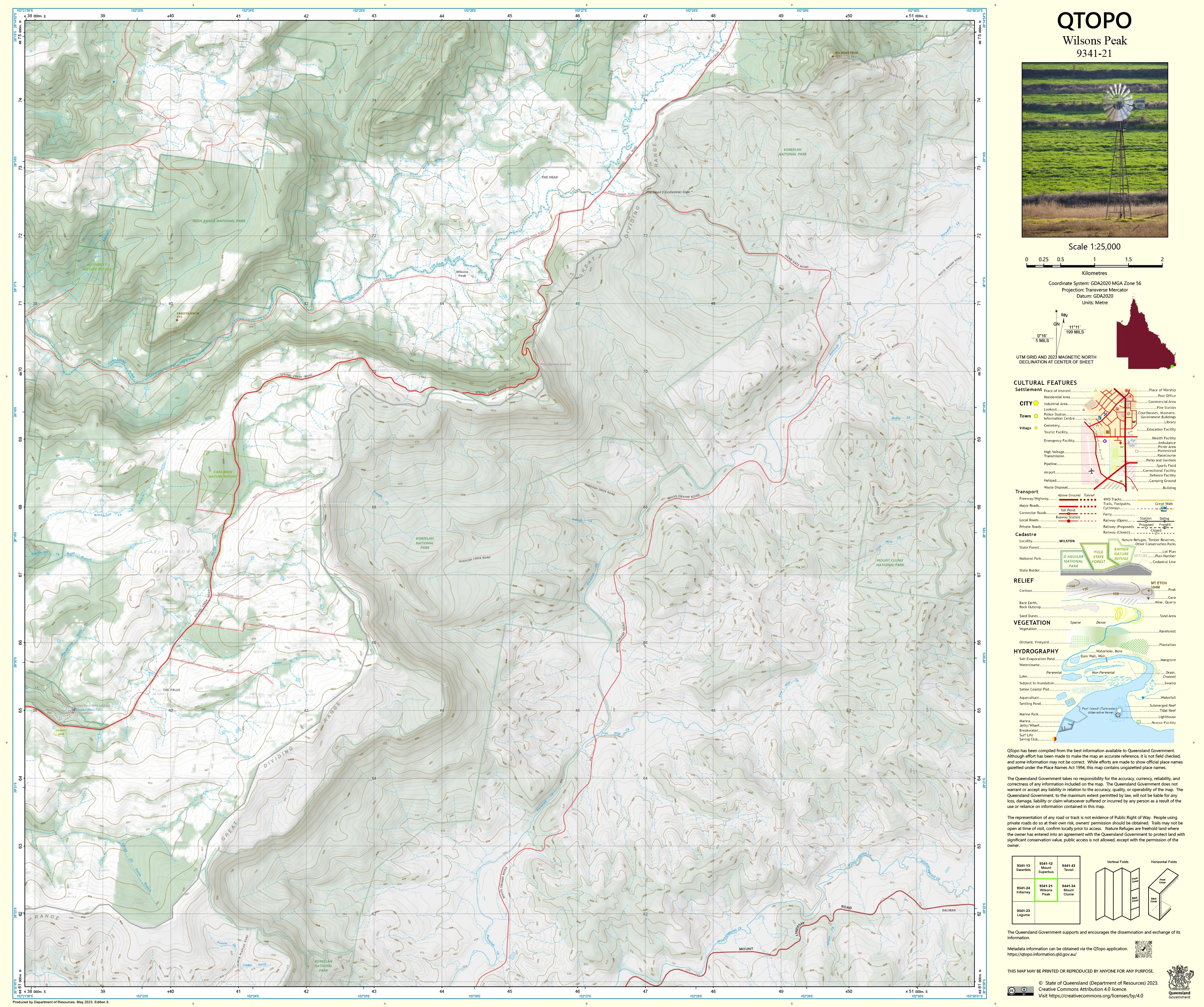
9341-21 Wilsons Peak QTopo 1:25,000 Topographic Map
QTopo 9341-21 — Wilsons Peak
1:25,000 Topographic Map
A high-precision topographic map covering the rugged Wilsons Peak region—where Queensland meets New South Wales along one of the most dramatic stretches of the McPherson Range. Defined by steep volcanic peaks, knife-edge ridgelines, deep rainforest valleys, and remote wilderness terrain, this area demands accurate mapping for safe navigation and professional fieldwork.
The QTopo 9341-21 (Wilsons Peak) sheet—produced by the Queensland Department of Resources—is part of the state’s authoritative 1:25,000 topographic mapping series. It provides detailed elevation modelling, hydrology mapping, vegetation structure, and access information across one of the most remote and technically challenging parts of the Scenic Rim.
Whether you're traversing the border ridge, conducting ecological surveys, navigating dense rainforest country, or assessing steep mountain environments, QTopo 9341-21 delivers the clarity and reliability required for confident and informed decision-making.
🗺️ Map Content and Features
At 1:25,000 scale—where 1 cm = 250 m—this detailed map includes:
-
Contour lines showing steep volcanic summits, narrow ridges, spurs, escarpments, cliffs, and deeply incised valleys
-
Hydrology features: creeks, waterfalls, gorge systems, drainage lines, and upper catchment tributaries
-
Walking tracks & access routes used by experienced hikers, rangers, and research teams
-
Infrastructure including access roads, fire trails, fencelines, communication assets, and remote facilities
-
Vegetation mapping covering rainforest, wet sclerophyll forest, montane vegetation, woodland, and riparian systems
-
Land tenure boundaries: national park, state forest, wilderness zones, and nearby freehold parcels
-
Named natural features including Wilsons Peak, Teviot Brook catchments, ridge networks, and volcanic high points
-
Points of interest for emergency services, ecologists, surveyors, and serious bushwalkers
Every QTopo map is built from Queensland’s authoritative spatial datasets, ensuring accuracy and consistency across the series.
🧭 Who Uses This Map?
The Wilsons Peak 9341-21 Topographic Map is widely used by:
-
Hikers & bushwalkers – navigating steep summit routes, ridge traverses, and dense rainforest
-
Environmental scientists & ecologists – fauna/flora surveys, habitat assessment, fire ecology studies
-
Surveyors & planners – steep-slope modelling, boundary work, terrain analysis
-
Rangers & conservation officers – managing protected areas and monitoring sensitive ecosystems
-
Emergency services & SES – search & rescue, fire management, and rugged-terrain response
-
Outdoor educators – teaching advanced navigation in technically demanding mountain environments
-
4WD/backcountry explorers – travelling remote border-country access tracks
A trusted resource for both professional and advanced recreational users.
💧 Field-Ready Options for Steep, Remote Mountain Terrain
Choose a print finish suited to Wilsons Peak’s heavy rainfall, dense vegetation, and exposed volcanic ridges.
✅ Waterproof & Tearproof Tyvek®
-
Printed on DuPont™ Tyvek®
-
Completely waterproof, tear-resistant, lightweight, and rugged
-
Ideal for all-weather fieldwork, creek crossings, and repeated handling
✅ Laminated Edition
-
Encapsulated in 2 × 80-micron gloss laminate
-
Writeable surface compatible with whiteboard markers
-
Wipe-clean and resistant to mud, moisture, dust, and impact
📄 Standard Paper Edition
-
High-resolution printing
-
Ideal for planning, study, reference, and occasional field use
📐 Map Details
Title: QTopo 9341-21 — Wilsons Peak
Publisher: Queensland Department of Resources
Series: QTopo 1:25,000
Scale: 1:25,000 (1 cm = 250 m)
Dimensions: 710 mm (width) × 594 mm (height)
Coverage: Wilsons Peak, McPherson Range, volcanic ridgelines, creek catchments, rainforest valleys, and surrounding remote mountain terrain
Material Options: Paper, laminated, or waterproof Tyvek®
Printed in: Australia
Edition: Latest available (see listing for publication year)
📥 QTopo Map Index
Need adjoining Scenic Rim or Main Range mapping?
➡️ Share adjacent sheet numbers—such as 9341-11, 9341-12, or 9441-13—and I’ll identify the adjoining maps instantly.
🛒 Ordering & Options
-
Standard folded paper map – ideal for planning, study, and reference
-
Tyvek® waterproof edition – perfect for rugged, wet, high-altitude fieldwork
-
Laminated edition – reusable, durable, and suited for operational or instructional use
-
Flat (unfolded) maps available for wall or workspace display
🎯 Summary
The QTopo 9341-21 — Wilsons Peak Topographic Map delivers essential detail on terrain, hydrology, vegetation, access, and land use across one of the most remote and spectacular volcanic landscapes on the Queensland–NSW border. With accurate 1:25,000 mapping and field-tough print options, it is indispensable for ecologists, rangers, surveyors, emergency crews, and experienced explorers.
Plan with purpose.
Navigate with confidence.
Explore with accuracy.
Choose your preferred finish today and take Wilsons Peak into the field with Queensland’s most trusted topographic mapping.
Original: $14.27
-65%$14.27
$4.99Product Information
Product Information
Shipping & Returns
Shipping & Returns
Description
QTopo 9341-21 — Wilsons Peak
1:25,000 Topographic Map
A high-precision topographic map covering the rugged Wilsons Peak region—where Queensland meets New South Wales along one of the most dramatic stretches of the McPherson Range. Defined by steep volcanic peaks, knife-edge ridgelines, deep rainforest valleys, and remote wilderness terrain, this area demands accurate mapping for safe navigation and professional fieldwork.
The QTopo 9341-21 (Wilsons Peak) sheet—produced by the Queensland Department of Resources—is part of the state’s authoritative 1:25,000 topographic mapping series. It provides detailed elevation modelling, hydrology mapping, vegetation structure, and access information across one of the most remote and technically challenging parts of the Scenic Rim.
Whether you're traversing the border ridge, conducting ecological surveys, navigating dense rainforest country, or assessing steep mountain environments, QTopo 9341-21 delivers the clarity and reliability required for confident and informed decision-making.
🗺️ Map Content and Features
At 1:25,000 scale—where 1 cm = 250 m—this detailed map includes:
-
Contour lines showing steep volcanic summits, narrow ridges, spurs, escarpments, cliffs, and deeply incised valleys
-
Hydrology features: creeks, waterfalls, gorge systems, drainage lines, and upper catchment tributaries
-
Walking tracks & access routes used by experienced hikers, rangers, and research teams
-
Infrastructure including access roads, fire trails, fencelines, communication assets, and remote facilities
-
Vegetation mapping covering rainforest, wet sclerophyll forest, montane vegetation, woodland, and riparian systems
-
Land tenure boundaries: national park, state forest, wilderness zones, and nearby freehold parcels
-
Named natural features including Wilsons Peak, Teviot Brook catchments, ridge networks, and volcanic high points
-
Points of interest for emergency services, ecologists, surveyors, and serious bushwalkers
Every QTopo map is built from Queensland’s authoritative spatial datasets, ensuring accuracy and consistency across the series.
🧭 Who Uses This Map?
The Wilsons Peak 9341-21 Topographic Map is widely used by:
-
Hikers & bushwalkers – navigating steep summit routes, ridge traverses, and dense rainforest
-
Environmental scientists & ecologists – fauna/flora surveys, habitat assessment, fire ecology studies
-
Surveyors & planners – steep-slope modelling, boundary work, terrain analysis
-
Rangers & conservation officers – managing protected areas and monitoring sensitive ecosystems
-
Emergency services & SES – search & rescue, fire management, and rugged-terrain response
-
Outdoor educators – teaching advanced navigation in technically demanding mountain environments
-
4WD/backcountry explorers – travelling remote border-country access tracks
A trusted resource for both professional and advanced recreational users.
💧 Field-Ready Options for Steep, Remote Mountain Terrain
Choose a print finish suited to Wilsons Peak’s heavy rainfall, dense vegetation, and exposed volcanic ridges.
✅ Waterproof & Tearproof Tyvek®
-
Printed on DuPont™ Tyvek®
-
Completely waterproof, tear-resistant, lightweight, and rugged
-
Ideal for all-weather fieldwork, creek crossings, and repeated handling
✅ Laminated Edition
-
Encapsulated in 2 × 80-micron gloss laminate
-
Writeable surface compatible with whiteboard markers
-
Wipe-clean and resistant to mud, moisture, dust, and impact
📄 Standard Paper Edition
-
High-resolution printing
-
Ideal for planning, study, reference, and occasional field use
📐 Map Details
Title: QTopo 9341-21 — Wilsons Peak
Publisher: Queensland Department of Resources
Series: QTopo 1:25,000
Scale: 1:25,000 (1 cm = 250 m)
Dimensions: 710 mm (width) × 594 mm (height)
Coverage: Wilsons Peak, McPherson Range, volcanic ridgelines, creek catchments, rainforest valleys, and surrounding remote mountain terrain
Material Options: Paper, laminated, or waterproof Tyvek®
Printed in: Australia
Edition: Latest available (see listing for publication year)
📥 QTopo Map Index
Need adjoining Scenic Rim or Main Range mapping?
➡️ Share adjacent sheet numbers—such as 9341-11, 9341-12, or 9441-13—and I’ll identify the adjoining maps instantly.
🛒 Ordering & Options
-
Standard folded paper map – ideal for planning, study, and reference
-
Tyvek® waterproof edition – perfect for rugged, wet, high-altitude fieldwork
-
Laminated edition – reusable, durable, and suited for operational or instructional use
-
Flat (unfolded) maps available for wall or workspace display
🎯 Summary
The QTopo 9341-21 — Wilsons Peak Topographic Map delivers essential detail on terrain, hydrology, vegetation, access, and land use across one of the most remote and spectacular volcanic landscapes on the Queensland–NSW border. With accurate 1:25,000 mapping and field-tough print options, it is indispensable for ecologists, rangers, surveyors, emergency crews, and experienced explorers.
Plan with purpose.
Navigate with confidence.
Explore with accuracy.
Choose your preferred finish today and take Wilsons Peak into the field with Queensland’s most trusted topographic mapping.


