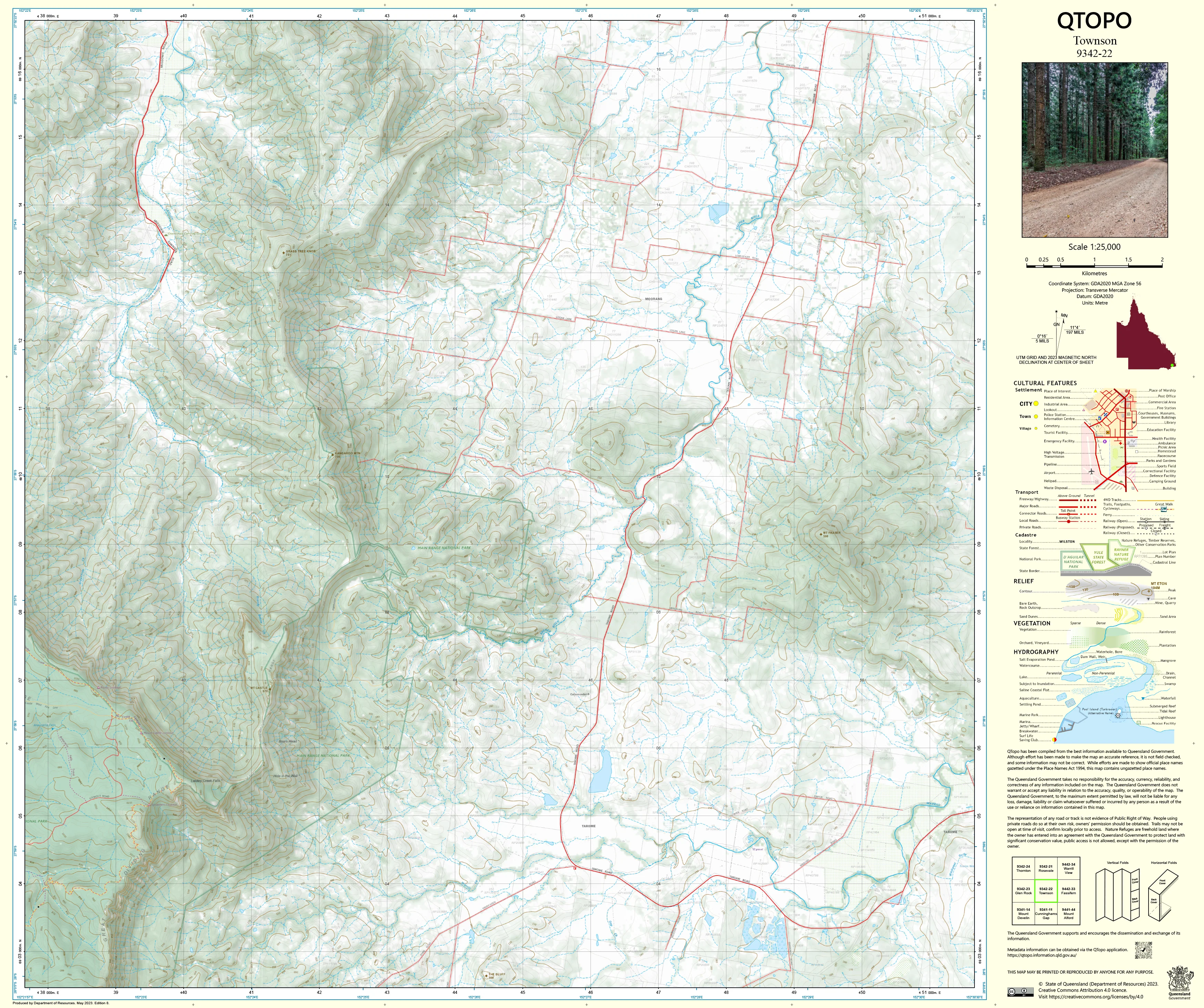
9342-22 Townson QTopo 1:25,000 Topographic Map
QTopo 9342-22 — Townson
1:25,000 Topographic Map
A highly detailed topographic map covering the Townson region—an area of expansive rural landscapes, rolling foothills, productive farmland, and winding creek systems situated between the Lockyer Valley and the western slopes of the Main Range. With its mix of grazing country, forested ridges, and irrigation corridors, this region requires accurate mapping for land management, environmental assessment, and safe navigation.
The QTopo 9342-22 (Townson) sheet—produced by the Queensland Department of Resources—forms part of Queensland’s authoritative 1:25,000 topographic mapping series. It provides detailed terrain representation, hydrology mapping, vegetation structure, and access information across one of the Lockyer region’s most diverse and agriculturally significant landscapes.
Whether you're conducting farm planning, navigating rural roads, mapping creek catchments, or undertaking ecological fieldwork, QTopo 9342-22 delivers the clarity, accuracy, and reliability essential for informed decision-making.
🗺️ Map Content and Features
At 1:25,000 scale—where 1 cm = 250 m—this map includes:
-
Contour lines showing gentle to moderate hills, rolling slopes, ridgelines, and drainage valleys
-
Hydrology features: creeks, tributaries, dams, irrigation channels, waterholes, and seasonal flows
-
Roads, rural access tracks & 4WD routes connecting farms, homesteads, forest areas, and local communities
-
Infrastructure including sheds, fencelines, silos, powerlines, communication towers, and rural facilities
-
Vegetation mapping covering farmland, woodland, forest remnants, scrub, and riparian corridors
-
Land tenure boundaries: freehold land, reserves, state land, and designated rural holdings
-
Named natural features such as ridges, hills, creek corridors, plains, and property landmarks
-
Points of interest for landholders, surveyors, ecologists, emergency services, and planners
All QTopo sheets use Queensland’s authoritative spatial datasets, ensuring dependable accuracy and consistency.
🧭 Who Uses This Map?
The Townson 9342-22 Topographic Map is widely relied upon by:
-
Graziers & agricultural operators – paddock layout, irrigation planning, and water resource management
-
Environmental scientists & ecologists – habitat surveys, catchment assessment, biodiversity studies
-
Surveyors & planners – boundary definition, terrain assessment, and infrastructure planning
-
Emergency services & SES – flood modelling, bushfire planning, and rural response coordination
-
4WD travellers & outdoor explorers – navigating rural and semi-remote landscapes
-
Outdoor educators & students – teaching foundational topographic interpretation
A trusted tool across agricultural, environmental, and operational fields.
💧 Field-Ready Options for Rural & Foothill Conditions
Choose a finish suited to Townson’s dry summers, wet-season storms, and varied terrain.
✅ Waterproof & Tearproof Tyvek®
-
Printed on DuPont™ Tyvek®
-
Fully waterproof, tear-resistant, lightweight, and robust
-
Ideal for wet-weather fieldwork and repeated handling
✅ Laminated Edition
-
Encapsulated in 2 × 80-micron gloss laminate
-
Writeable surface suitable for mapping routes or planning activities
-
Wipe-clean and resistant to mud, dust, moisture, and abrasion
📄 Standard Paper Edition
-
Crisp, high-resolution print
-
Perfect for office planning, study, and occasional outdoor use
📐 Map Details
Title: QTopo 9342-22 — Townson
Publisher: Queensland Department of Resources
Series: QTopo 1:25,000
Scale: 1:25,000 (1 cm = 250 m)
Dimensions: 710 mm (width) × 594 mm (height)
Coverage: Townson region including rural properties, creek systems, rolling hills, farmland, access tracks, and forest remnants
Material Options: Paper, laminated, or waterproof Tyvek®
Printed in: Australia
Edition: Latest available (see listing for publication year)
📥 QTopo Map Index
Need neighbouring Lockyer Valley or Main Range coverage?
➡️ Share nearby sheet numbers—such as 9342-21, 9342-23, or 9242-12—and I’ll identify the adjoining maps instantly.
🛒 Ordering & Options
-
Standard folded paper map – ideal for planning and reference
-
Tyvek® waterproof edition – excellent for all-weather fieldwork
-
Laminated edition – durable, reusable, and suitable for operational or educational use
-
Flat (unfolded) maps available for wall or workspace display
🎯 Summary
The QTopo 9342-22 — Townson Topographic Map provides essential detail on terrain, hydrology, vegetation, access, and land use across one of the Lockyer region’s most productive and varied rural landscapes. With accurate 1:25,000 mapping and rugged print formats, it is indispensable for landholders, surveyors, ecologists, emergency responders, and regional planners.
Plan with purpose.
Navigate with confidence.
Explore with clarity.
Choose your preferred finish today and take Townson into the field with Queensland’s most trusted topographic mapping.
Original: $14.27
-65%$14.27
$4.99Product Information
Product Information
Shipping & Returns
Shipping & Returns
Description
QTopo 9342-22 — Townson
1:25,000 Topographic Map
A highly detailed topographic map covering the Townson region—an area of expansive rural landscapes, rolling foothills, productive farmland, and winding creek systems situated between the Lockyer Valley and the western slopes of the Main Range. With its mix of grazing country, forested ridges, and irrigation corridors, this region requires accurate mapping for land management, environmental assessment, and safe navigation.
The QTopo 9342-22 (Townson) sheet—produced by the Queensland Department of Resources—forms part of Queensland’s authoritative 1:25,000 topographic mapping series. It provides detailed terrain representation, hydrology mapping, vegetation structure, and access information across one of the Lockyer region’s most diverse and agriculturally significant landscapes.
Whether you're conducting farm planning, navigating rural roads, mapping creek catchments, or undertaking ecological fieldwork, QTopo 9342-22 delivers the clarity, accuracy, and reliability essential for informed decision-making.
🗺️ Map Content and Features
At 1:25,000 scale—where 1 cm = 250 m—this map includes:
-
Contour lines showing gentle to moderate hills, rolling slopes, ridgelines, and drainage valleys
-
Hydrology features: creeks, tributaries, dams, irrigation channels, waterholes, and seasonal flows
-
Roads, rural access tracks & 4WD routes connecting farms, homesteads, forest areas, and local communities
-
Infrastructure including sheds, fencelines, silos, powerlines, communication towers, and rural facilities
-
Vegetation mapping covering farmland, woodland, forest remnants, scrub, and riparian corridors
-
Land tenure boundaries: freehold land, reserves, state land, and designated rural holdings
-
Named natural features such as ridges, hills, creek corridors, plains, and property landmarks
-
Points of interest for landholders, surveyors, ecologists, emergency services, and planners
All QTopo sheets use Queensland’s authoritative spatial datasets, ensuring dependable accuracy and consistency.
🧭 Who Uses This Map?
The Townson 9342-22 Topographic Map is widely relied upon by:
-
Graziers & agricultural operators – paddock layout, irrigation planning, and water resource management
-
Environmental scientists & ecologists – habitat surveys, catchment assessment, biodiversity studies
-
Surveyors & planners – boundary definition, terrain assessment, and infrastructure planning
-
Emergency services & SES – flood modelling, bushfire planning, and rural response coordination
-
4WD travellers & outdoor explorers – navigating rural and semi-remote landscapes
-
Outdoor educators & students – teaching foundational topographic interpretation
A trusted tool across agricultural, environmental, and operational fields.
💧 Field-Ready Options for Rural & Foothill Conditions
Choose a finish suited to Townson’s dry summers, wet-season storms, and varied terrain.
✅ Waterproof & Tearproof Tyvek®
-
Printed on DuPont™ Tyvek®
-
Fully waterproof, tear-resistant, lightweight, and robust
-
Ideal for wet-weather fieldwork and repeated handling
✅ Laminated Edition
-
Encapsulated in 2 × 80-micron gloss laminate
-
Writeable surface suitable for mapping routes or planning activities
-
Wipe-clean and resistant to mud, dust, moisture, and abrasion
📄 Standard Paper Edition
-
Crisp, high-resolution print
-
Perfect for office planning, study, and occasional outdoor use
📐 Map Details
Title: QTopo 9342-22 — Townson
Publisher: Queensland Department of Resources
Series: QTopo 1:25,000
Scale: 1:25,000 (1 cm = 250 m)
Dimensions: 710 mm (width) × 594 mm (height)
Coverage: Townson region including rural properties, creek systems, rolling hills, farmland, access tracks, and forest remnants
Material Options: Paper, laminated, or waterproof Tyvek®
Printed in: Australia
Edition: Latest available (see listing for publication year)
📥 QTopo Map Index
Need neighbouring Lockyer Valley or Main Range coverage?
➡️ Share nearby sheet numbers—such as 9342-21, 9342-23, or 9242-12—and I’ll identify the adjoining maps instantly.
🛒 Ordering & Options
-
Standard folded paper map – ideal for planning and reference
-
Tyvek® waterproof edition – excellent for all-weather fieldwork
-
Laminated edition – durable, reusable, and suitable for operational or educational use
-
Flat (unfolded) maps available for wall or workspace display
🎯 Summary
The QTopo 9342-22 — Townson Topographic Map provides essential detail on terrain, hydrology, vegetation, access, and land use across one of the Lockyer region’s most productive and varied rural landscapes. With accurate 1:25,000 mapping and rugged print formats, it is indispensable for landholders, surveyors, ecologists, emergency responders, and regional planners.
Plan with purpose.
Navigate with confidence.
Explore with clarity.
Choose your preferred finish today and take Townson into the field with Queensland’s most trusted topographic mapping.


