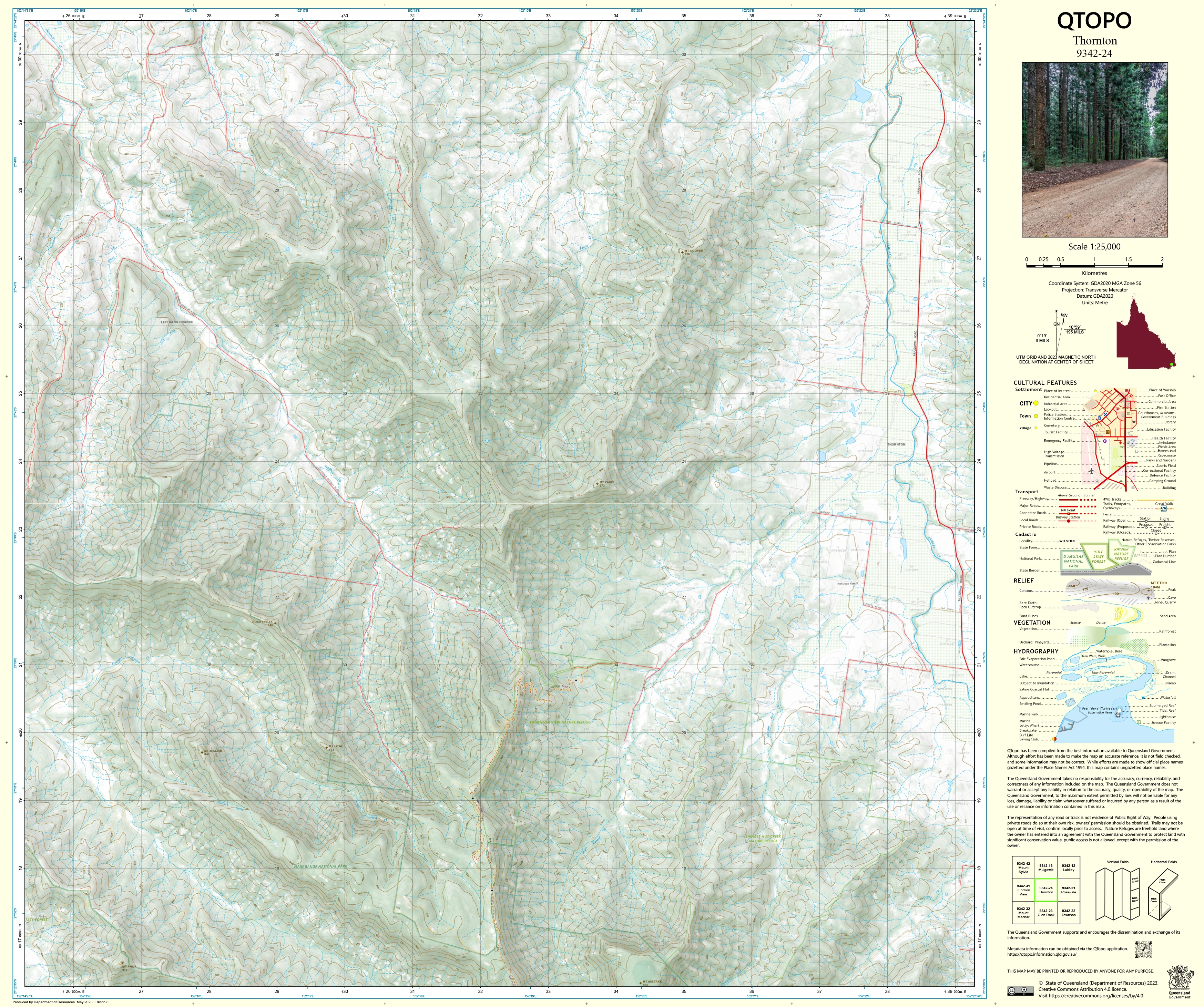
9342-24 Thornton QTopo 1:25,000 Topographic Map
QTopo 9342-24 — Thornton
1:25,000 Topographic Map
A detailed and accurate topographic map covering the Thornton region—where rich farmland, rolling foothills, and winding creek systems meet the steep volcanic slopes of the Main Range. With its productive agricultural landscapes, forested ridges, and deep drainage valleys, Thornton is an area where precise mapping is essential for land management, environmental work, and rural navigation.
The QTopo 9342-24 (Thornton) sheet—produced by the Queensland Department of Resources—is part of the state’s authoritative 1:25,000 topographic mapping series. It provides high-quality elevation modelling, hydrology mapping, vegetation structure, and infrastructure detail across one of the Lockyer region’s most diverse and actively managed landscapes.
Whether you’re planning rural operations, mapping creek systems, undertaking environmental surveys, or navigating the mix of open farmland and steep foothill country, QTopo 9342-24 offers the clarity and accuracy required for effective fieldwork.
🗺️ Map Content and Features
At 1:25,000 scale—where 1 cm = 250 m—this high-resolution map includes:
-
Contour lines showing rolling hills, volcanic foothills, escarpments, ridges, and drainage valleys
-
Hydrology features: creeks, tributaries, dams, irrigation channels, waterholes, and seasonal waterways
-
Roads, rural access tracks & property routes linking farms, homesteads, community areas, and forest zones
-
Infrastructure including fencelines, utilities, sheds, silos, powerlines, and communication towers
-
Vegetation mapping covering farmland, woodland, forest remnants, scrub, and riparian corridors
-
Land tenure boundaries: freehold land, reserves, state land, and managed agricultural parcels
-
Named natural features including hills, creek corridors, ridgelines, plains, and notable terrain markers
-
Points of interest important for surveyors, land managers, ecologists, and emergency planners
All QTopo maps draw from Queensland’s official spatial datasets, ensuring dependable accuracy and consistency.
🧭 Who Uses This Map?
The Thornton 9342-24 Topographic Map is widely used by:
-
Graziers & agricultural operators – paddock planning, irrigation design, and property management
-
Environmental scientists & ecologists – vegetation studies, catchment assessments, biodiversity surveys
-
Surveyors & planners – boundary work, terrain analysis, and land-use evaluation
-
Emergency services & SES – flood modelling, bushfire response, and rural operations
-
4WD travellers & outdoor explorers – navigating rural and semi-remote landscapes
-
Educators & students – teaching foundational map-reading and landform interpretation
A trusted reference for both professional and recreational users.
💧 Field-Ready Options for Rural & Foothill Environments
Choose a finish suited to Thornton’s dry-season conditions, storm-season variability, and mixed topography.
✅ Waterproof & Tearproof Tyvek®
-
Printed on DuPont™ Tyvek®
-
Fully waterproof, tear-resistant, lightweight, and durable
-
Ideal for creek-side work, irrigation planning, and all-weather field use
✅ Laminated Edition
-
Encapsulated in 2 × 80-micron gloss laminate
-
Writeable surface compatible with whiteboard markers
-
Wipe-clean and resistant to moisture, mud, dust, and abrasion
📄 Standard Paper Edition
-
Crisp, high-resolution print
-
Perfect for planning, desk reference, and occasional outdoor use
📐 Map Details
Title: QTopo 9342-24 — Thornton
Publisher: Queensland Department of Resources
Series: QTopo 1:25,000
Scale: 1:25,000 (1 cm = 250 m)
Dimensions: 710 mm (width) × 594 mm (height)
Coverage: Thornton district including farmland, creek systems, rolling hills, volcanic foothills, and rural access routes
Material Options: Paper, laminated, or waterproof Tyvek®
Printed in: Australia
Edition: Latest available (see listing for publication year)
📥 QTopo Map Index
Need neighbouring Lockyer Valley or Main Range coverage?
➡️ Provide nearby sheet numbers—such as 9342-23, 9342-25, or 9242-13—and I’ll identify the adjoining maps instantly.
🛒 Ordering & Options
-
Standard folded paper map – ideal for planning and everyday reference
-
Tyvek® waterproof edition – built for rugged, all-weather rural and foothill fieldwork
-
Laminated edition – durable, reusable, and suitable for operational planning
-
Flat (unfolded) maps available for wall or workspace display
🎯 Summary
The QTopo 9342-24 — Thornton Topographic Map provides essential detail on terrain, hydrology, vegetation, access routes, and land use across one of the Lockyer region’s most productive and topographically varied landscapes. With precise 1:25,000 mapping and field-tough print options, it is indispensable for farmers, ecologists, surveyors, emergency personnel, and rural explorers.
Plan with purpose.
Navigate with confidence.
Explore with clarity.
Choose your preferred finish today and take Thornton into the field with Queensland’s most trusted topographic mapping.
Original: $14.27
-65%$14.27
$4.99Product Information
Product Information
Shipping & Returns
Shipping & Returns
Description
QTopo 9342-24 — Thornton
1:25,000 Topographic Map
A detailed and accurate topographic map covering the Thornton region—where rich farmland, rolling foothills, and winding creek systems meet the steep volcanic slopes of the Main Range. With its productive agricultural landscapes, forested ridges, and deep drainage valleys, Thornton is an area where precise mapping is essential for land management, environmental work, and rural navigation.
The QTopo 9342-24 (Thornton) sheet—produced by the Queensland Department of Resources—is part of the state’s authoritative 1:25,000 topographic mapping series. It provides high-quality elevation modelling, hydrology mapping, vegetation structure, and infrastructure detail across one of the Lockyer region’s most diverse and actively managed landscapes.
Whether you’re planning rural operations, mapping creek systems, undertaking environmental surveys, or navigating the mix of open farmland and steep foothill country, QTopo 9342-24 offers the clarity and accuracy required for effective fieldwork.
🗺️ Map Content and Features
At 1:25,000 scale—where 1 cm = 250 m—this high-resolution map includes:
-
Contour lines showing rolling hills, volcanic foothills, escarpments, ridges, and drainage valleys
-
Hydrology features: creeks, tributaries, dams, irrigation channels, waterholes, and seasonal waterways
-
Roads, rural access tracks & property routes linking farms, homesteads, community areas, and forest zones
-
Infrastructure including fencelines, utilities, sheds, silos, powerlines, and communication towers
-
Vegetation mapping covering farmland, woodland, forest remnants, scrub, and riparian corridors
-
Land tenure boundaries: freehold land, reserves, state land, and managed agricultural parcels
-
Named natural features including hills, creek corridors, ridgelines, plains, and notable terrain markers
-
Points of interest important for surveyors, land managers, ecologists, and emergency planners
All QTopo maps draw from Queensland’s official spatial datasets, ensuring dependable accuracy and consistency.
🧭 Who Uses This Map?
The Thornton 9342-24 Topographic Map is widely used by:
-
Graziers & agricultural operators – paddock planning, irrigation design, and property management
-
Environmental scientists & ecologists – vegetation studies, catchment assessments, biodiversity surveys
-
Surveyors & planners – boundary work, terrain analysis, and land-use evaluation
-
Emergency services & SES – flood modelling, bushfire response, and rural operations
-
4WD travellers & outdoor explorers – navigating rural and semi-remote landscapes
-
Educators & students – teaching foundational map-reading and landform interpretation
A trusted reference for both professional and recreational users.
💧 Field-Ready Options for Rural & Foothill Environments
Choose a finish suited to Thornton’s dry-season conditions, storm-season variability, and mixed topography.
✅ Waterproof & Tearproof Tyvek®
-
Printed on DuPont™ Tyvek®
-
Fully waterproof, tear-resistant, lightweight, and durable
-
Ideal for creek-side work, irrigation planning, and all-weather field use
✅ Laminated Edition
-
Encapsulated in 2 × 80-micron gloss laminate
-
Writeable surface compatible with whiteboard markers
-
Wipe-clean and resistant to moisture, mud, dust, and abrasion
📄 Standard Paper Edition
-
Crisp, high-resolution print
-
Perfect for planning, desk reference, and occasional outdoor use
📐 Map Details
Title: QTopo 9342-24 — Thornton
Publisher: Queensland Department of Resources
Series: QTopo 1:25,000
Scale: 1:25,000 (1 cm = 250 m)
Dimensions: 710 mm (width) × 594 mm (height)
Coverage: Thornton district including farmland, creek systems, rolling hills, volcanic foothills, and rural access routes
Material Options: Paper, laminated, or waterproof Tyvek®
Printed in: Australia
Edition: Latest available (see listing for publication year)
📥 QTopo Map Index
Need neighbouring Lockyer Valley or Main Range coverage?
➡️ Provide nearby sheet numbers—such as 9342-23, 9342-25, or 9242-13—and I’ll identify the adjoining maps instantly.
🛒 Ordering & Options
-
Standard folded paper map – ideal for planning and everyday reference
-
Tyvek® waterproof edition – built for rugged, all-weather rural and foothill fieldwork
-
Laminated edition – durable, reusable, and suitable for operational planning
-
Flat (unfolded) maps available for wall or workspace display
🎯 Summary
The QTopo 9342-24 — Thornton Topographic Map provides essential detail on terrain, hydrology, vegetation, access routes, and land use across one of the Lockyer region’s most productive and topographically varied landscapes. With precise 1:25,000 mapping and field-tough print options, it is indispensable for farmers, ecologists, surveyors, emergency personnel, and rural explorers.
Plan with purpose.
Navigate with confidence.
Explore with clarity.
Choose your preferred finish today and take Thornton into the field with Queensland’s most trusted topographic mapping.


