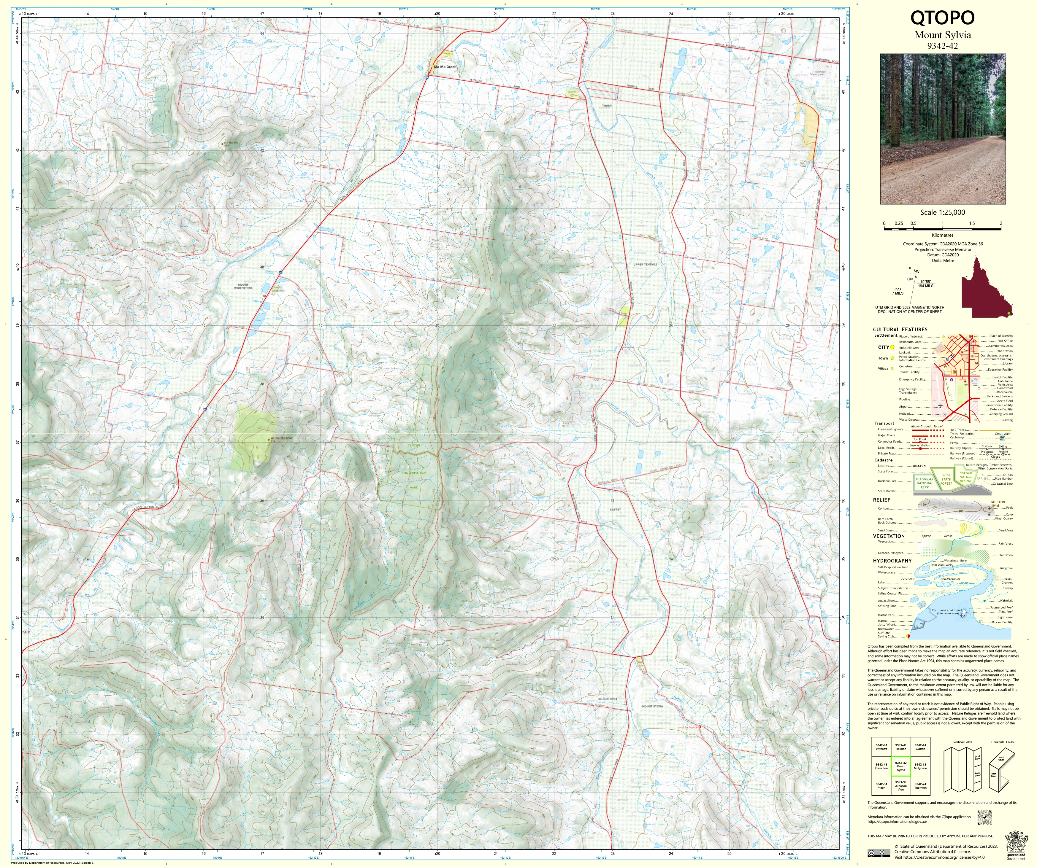
9342-42 Mount Sylvia QTopo 1:25,000 Topographic Map
QTopo 9342-42 — Mount Sylvia
1:25,000 Topographic Map
A highly detailed topographic map covering the Mount Sylvia region—an area of rich agricultural land, winding creek systems, rolling hills, and steep volcanic foothills at the southern edge of the Lockyer Valley. With its blend of farms, rural settlements, forested ridges, and complex drainage patterns, Mount Sylvia is a landscape where accurate, reliable mapping is essential.
The QTopo 9342-42 (Mount Sylvia) sheet—produced by the Queensland Department of Resources—forms part of the authoritative 1:25,000 topographic mapping series. It provides comprehensive elevation modelling, hydrological detail, vegetation structure, and access information across one of the valley’s most varied and productive districts.
Whether you're planning property improvements, conducting ecological fieldwork, mapping creek catchments, or navigating backcountry routes, QTopo 9342-42 delivers the precision and clarity required for safe and informed decision-making.
🗺️ Map Content and Features
At 1:25,000 scale—meaning 1 cm = 250 m—this map includes:
-
Contour lines revealing steep foothills, rolling farmland, ridgelines, and drainage valleys
-
Hydrology features: creeks, tributaries, dams, waterholes, irrigation channels, and seasonal flows
-
Roads, rural access tracks & property routes linking farms, small communities, and forest edges
-
Infrastructure including fencelines, sheds, silos, powerlines, water infrastructure, and communication towers
-
Vegetation mapping covering farmland, forest remnants, woodland, scrub, and riparian corridors
-
Land tenure boundaries: freehold land, reserves, state land, and managed agricultural parcels
-
Named natural features such as Mount Sylvia, hills, creek corridors, plains, and ridge systems
-
Points of interest relevant to surveyors, landholders, ecologists, and emergency services
Every QTopo map is produced from Queensland’s authoritative spatial datasets for consistent, dependable accuracy.
🧭 Who Uses This Map?
The Mount Sylvia 9342-42 Topographic Map is widely used by:
-
Graziers & agricultural operators – planning paddocks, irrigation, and property infrastructure
-
Environmental scientists & ecologists – catchment assessments, habitat surveys, vegetation studies
-
Surveyors & land planners – boundary definition, terrain analysis, and rural development planning
-
Emergency services & SES – flood modelling, bushfire planning, and rural response coordination
-
4WD explorers & rural travellers – navigating backroads and semi-remote areas
-
Educators & students – learning landform interpretation and topographic map skills
A trusted reference for both professional and recreational use.
💧 Field-Ready Options for Rural & Foothill Conditions
Choose a finish suited to Mount Sylvia’s mix of dry farmland, wet-season creeks, and varied terrain.
✅ Waterproof & Tearproof Tyvek®
-
Printed on DuPont™ Tyvek®
-
Fully waterproof, tear-resistant, and lightweight
-
Ideal for repeated outdoor use in all weather conditions
✅ Laminated Edition
-
Encapsulated with 2 × 80-micron gloss laminate
-
Writeable surface for whiteboard markers
-
Wipe-clean and resistant to moisture, mud, dust, and abrasion
📄 Standard Paper Edition
-
Crisp, high-resolution printing
-
Perfect for planning, desk reference, and occasional fieldwork
📐 Map Details
Title: QTopo 9342-42 — Mount Sylvia
Publisher: Queensland Department of Resources
Series: QTopo 1:25,000
Scale: 1:25,000 (1 cm = 250 m)
Dimensions: 710 mm (width) × 594 mm (height)
Coverage: Mount Sylvia district including farms, rolling hills, creek systems, foothills, forest remnants, and rural road networks
Material Options: Paper, laminated, or waterproof Tyvek®
Printed in: Australia
Edition: Latest available (see listing for year)
📥 QTopo Map Index
Need coverage for neighbouring Lockyer Valley–Main Range areas?
➡️ Provide nearby sheet numbers—such as 9342-41, 9342-43, or 9242-32—and I’ll identify the adjoining maps instantly.
🛒 Ordering & Options
-
Standard folded paper map – ideal for planning and reference
-
Tyvek® waterproof edition – rugged and all-weather-ready
-
Laminated edition – durable, reusable, and suited to operational work
-
Flat (unfolded) maps available for wall or workspace display
🎯 Summary
The QTopo 9342-42 — Mount Sylvia Topographic Map provides essential detail on terrain, vegetation, hydrology, access routes, and land use across one of the Lockyer Valley’s most varied and productive landscapes. With precise 1:25,000 mapping and tough field-ready printing options, it is indispensable for surveyors, ecologists, landholders, emergency responders, and rural explorers.
Plan with purpose.
Navigate with confidence.
Explore with clarity.
Choose your preferred finish today and take Mount Sylvia into the field with Queensland’s most trusted topographic mapping.
Original: $14.27
-65%$14.27
$4.99Product Information
Product Information
Shipping & Returns
Shipping & Returns
Description
QTopo 9342-42 — Mount Sylvia
1:25,000 Topographic Map
A highly detailed topographic map covering the Mount Sylvia region—an area of rich agricultural land, winding creek systems, rolling hills, and steep volcanic foothills at the southern edge of the Lockyer Valley. With its blend of farms, rural settlements, forested ridges, and complex drainage patterns, Mount Sylvia is a landscape where accurate, reliable mapping is essential.
The QTopo 9342-42 (Mount Sylvia) sheet—produced by the Queensland Department of Resources—forms part of the authoritative 1:25,000 topographic mapping series. It provides comprehensive elevation modelling, hydrological detail, vegetation structure, and access information across one of the valley’s most varied and productive districts.
Whether you're planning property improvements, conducting ecological fieldwork, mapping creek catchments, or navigating backcountry routes, QTopo 9342-42 delivers the precision and clarity required for safe and informed decision-making.
🗺️ Map Content and Features
At 1:25,000 scale—meaning 1 cm = 250 m—this map includes:
-
Contour lines revealing steep foothills, rolling farmland, ridgelines, and drainage valleys
-
Hydrology features: creeks, tributaries, dams, waterholes, irrigation channels, and seasonal flows
-
Roads, rural access tracks & property routes linking farms, small communities, and forest edges
-
Infrastructure including fencelines, sheds, silos, powerlines, water infrastructure, and communication towers
-
Vegetation mapping covering farmland, forest remnants, woodland, scrub, and riparian corridors
-
Land tenure boundaries: freehold land, reserves, state land, and managed agricultural parcels
-
Named natural features such as Mount Sylvia, hills, creek corridors, plains, and ridge systems
-
Points of interest relevant to surveyors, landholders, ecologists, and emergency services
Every QTopo map is produced from Queensland’s authoritative spatial datasets for consistent, dependable accuracy.
🧭 Who Uses This Map?
The Mount Sylvia 9342-42 Topographic Map is widely used by:
-
Graziers & agricultural operators – planning paddocks, irrigation, and property infrastructure
-
Environmental scientists & ecologists – catchment assessments, habitat surveys, vegetation studies
-
Surveyors & land planners – boundary definition, terrain analysis, and rural development planning
-
Emergency services & SES – flood modelling, bushfire planning, and rural response coordination
-
4WD explorers & rural travellers – navigating backroads and semi-remote areas
-
Educators & students – learning landform interpretation and topographic map skills
A trusted reference for both professional and recreational use.
💧 Field-Ready Options for Rural & Foothill Conditions
Choose a finish suited to Mount Sylvia’s mix of dry farmland, wet-season creeks, and varied terrain.
✅ Waterproof & Tearproof Tyvek®
-
Printed on DuPont™ Tyvek®
-
Fully waterproof, tear-resistant, and lightweight
-
Ideal for repeated outdoor use in all weather conditions
✅ Laminated Edition
-
Encapsulated with 2 × 80-micron gloss laminate
-
Writeable surface for whiteboard markers
-
Wipe-clean and resistant to moisture, mud, dust, and abrasion
📄 Standard Paper Edition
-
Crisp, high-resolution printing
-
Perfect for planning, desk reference, and occasional fieldwork
📐 Map Details
Title: QTopo 9342-42 — Mount Sylvia
Publisher: Queensland Department of Resources
Series: QTopo 1:25,000
Scale: 1:25,000 (1 cm = 250 m)
Dimensions: 710 mm (width) × 594 mm (height)
Coverage: Mount Sylvia district including farms, rolling hills, creek systems, foothills, forest remnants, and rural road networks
Material Options: Paper, laminated, or waterproof Tyvek®
Printed in: Australia
Edition: Latest available (see listing for year)
📥 QTopo Map Index
Need coverage for neighbouring Lockyer Valley–Main Range areas?
➡️ Provide nearby sheet numbers—such as 9342-41, 9342-43, or 9242-32—and I’ll identify the adjoining maps instantly.
🛒 Ordering & Options
-
Standard folded paper map – ideal for planning and reference
-
Tyvek® waterproof edition – rugged and all-weather-ready
-
Laminated edition – durable, reusable, and suited to operational work
-
Flat (unfolded) maps available for wall or workspace display
🎯 Summary
The QTopo 9342-42 — Mount Sylvia Topographic Map provides essential detail on terrain, vegetation, hydrology, access routes, and land use across one of the Lockyer Valley’s most varied and productive landscapes. With precise 1:25,000 mapping and tough field-ready printing options, it is indispensable for surveyors, ecologists, landholders, emergency responders, and rural explorers.
Plan with purpose.
Navigate with confidence.
Explore with clarity.
Choose your preferred finish today and take Mount Sylvia into the field with Queensland’s most trusted topographic mapping.


