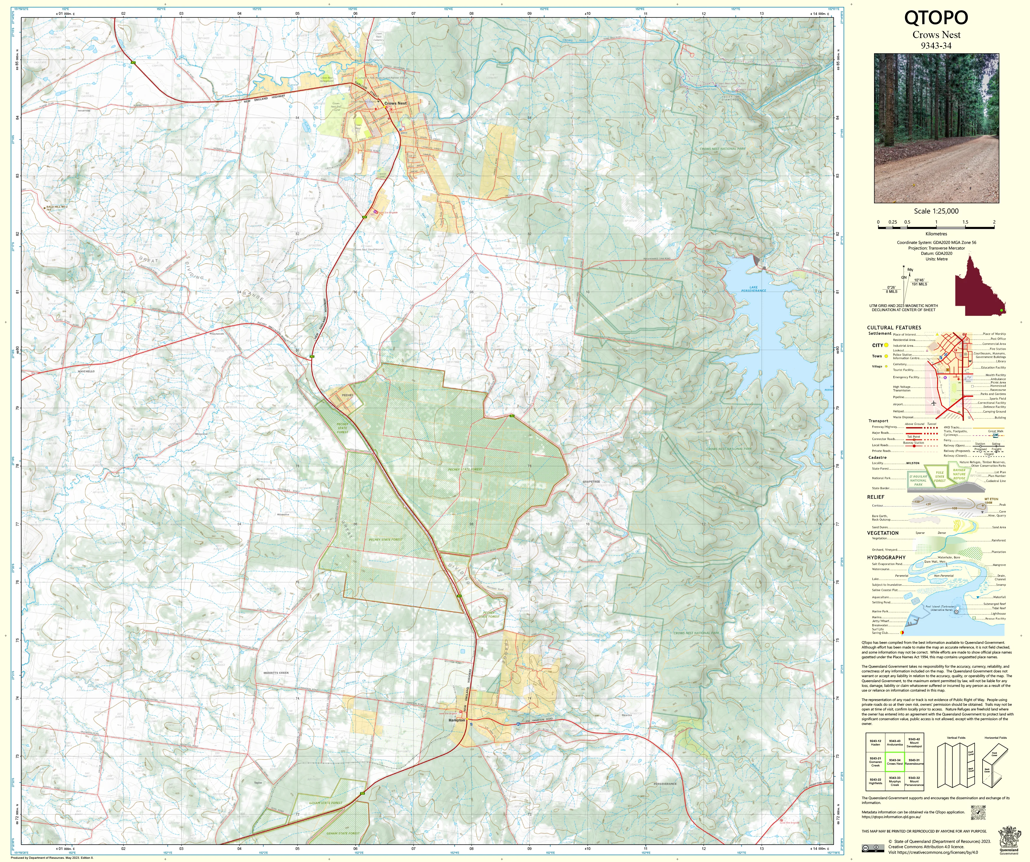
9343-34 Crows Nest QTopo 1:25,000 Topographic Map
QTopo 9343-34 — Crows Nest
1:25,000 Topographic Map
A highly detailed topographic map covering the Crows Nest region—an elevated landscape of granite outcrops, rolling uplands, steep gullies, state forest, and rich agricultural country on Queensland’s Darling Downs. Known for its cooler climate, scenic lookouts, rugged creek systems, and mixed land use, the area requires accurate mapping for safe navigation, land management, and environmental fieldwork.
The QTopo 9343-34 (Crows Nest) sheet—produced by the Queensland Department of Resources—is part of the state’s authoritative 1:25,000 mapping series. It delivers precise elevation modelling, hydrology detail, vegetation classification, and access mapping across one of the region’s most diverse and scenic high-country districts.
Whether you're undertaking environmental surveys, planning rural operations, exploring forest trails, or navigating steep granite country, QTopo 9343-34 provides the clarity and reliability needed for effective field decision-making.
🗺️ Map Content and Features
At 1:25,000 scale—where 1 cm = 250 m—this detailed map includes:
-
Contour lines revealing upland slopes, granite ridges, escarpments, spurs, and creek-cut valleys
-
Hydrology features: waterfalls, granite-lined creeks, tributaries, drainage networks, dams, and waterholes
-
Roads, 4WD tracks & forest routes linking rural properties, reserves, and state forest areas
-
Infrastructure such as fencelines, powerlines, communication towers, sheds, silos, and rural facilities
-
Vegetation mapping covering eucalypt forest, woodland, scrub, plantations, farmland, and riparian zones
-
Land tenure boundaries: national park, conservation reserve, state forest, freehold, and leasehold land
-
Named natural and man-made features including rocky bluffs, creek corridors, ridgelines, peaks, and local landmarks
-
Points of interest for hikers, ecologists, surveyors, land managers, and emergency responders
All QTopo sheets are constructed from Queensland’s official spatial datasets, ensuring high accuracy and consistency state-wide.
🧭 Who Uses This Map?
The Crows Nest 9343-34 Topographic Map is relied upon by:
-
Hikers & trail explorers – navigating lookouts, creeks, ridges, and forest tracks
-
Environmental scientists & ecologists – habitat surveys, species monitoring, fire management
-
Surveyors & land planners – boundary mapping, terrain assessment, and land-use evaluation
-
Rangers & forest managers – monitoring reserves, managing access routes, and planning operations
-
Emergency services & SES – response planning in rugged, tree-covered terrain
-
Rural landholders & graziers – managing paddocks, dams, and property access infrastructure
A trusted and versatile map for both professional and recreational use.
💧 Field-Ready Options for Upland & Forest Environments
Choose a print finish suited to Crows Nest’s wet gullies, granite slopes, and mixed forest terrain.
✅ Waterproof & Tearproof Tyvek®
-
Printed on DuPont™ Tyvek®
-
Fully waterproof, tear-resistant, and lightweight
-
Ideal for hiking, field research, and wet-weather operations
✅ Laminated Edition
-
Encapsulated in 2 × 80-micron gloss laminate
-
Writeable surface compatible with whiteboard markers
-
Wipe-clean and resistant to moisture, mud, dust, and heavy handling
📄 Standard Paper Edition
-
Crisp, high-resolution printing
-
Excellent for planning, office use, and occasional field reference
📐 Map Details
Title: QTopo 9343-34 — Crows Nest
Publisher: Queensland Department of Resources
Series: QTopo 1:25,000
Scale: 1:25,000 (1 cm = 250 m)
Dimensions: 710 mm (width) × 594 mm (height)
Coverage: Crows Nest district including upland farming areas, creek valleys, state forests, granite outcrops, ridgelines, and forest access routes
Material Options: Paper, laminated, or waterproof Tyvek®
Printed in: Australia
Edition: Latest available (see listing for publication year)
📥 QTopo Map Index
Need neighbouring Darling Downs or South Burnett sheets?
➡️ Provide adjacent sheet numbers—such as 9343-24, 9343-35, or 9443-03—and I’ll identify the adjoining maps instantly.
🛒 Ordering & Options
-
Standard folded paper map – perfect for study, planning, and general reference
-
Tyvek® waterproof edition – ideal for bushwalking and all-weather fieldwork
-
Laminated edition – durable, reusable, and suited for operational environments
-
Flat (unfolded) maps available for wall or workspace display
🎯 Summary
The QTopo 9343-34 — Crows Nest Topographic Map provides essential detail on terrain, hydrology, vegetation, rural infrastructure, and access routes across one of the most varied upland regions of Queensland’s Darling Downs. With its precise 1:25,000 mapping and rugged print options, it is indispensable for hikers, ecologists, surveyors, land managers, and emergency crews.
Plan with purpose.
Navigate with confidence.
Explore with clarity.
Choose your preferred finish today and take Crows Nest into the field with Queensland’s most dependable topographic mapping.
Original: $14.27
-65%$14.27
$4.99Product Information
Product Information
Shipping & Returns
Shipping & Returns
Description
QTopo 9343-34 — Crows Nest
1:25,000 Topographic Map
A highly detailed topographic map covering the Crows Nest region—an elevated landscape of granite outcrops, rolling uplands, steep gullies, state forest, and rich agricultural country on Queensland’s Darling Downs. Known for its cooler climate, scenic lookouts, rugged creek systems, and mixed land use, the area requires accurate mapping for safe navigation, land management, and environmental fieldwork.
The QTopo 9343-34 (Crows Nest) sheet—produced by the Queensland Department of Resources—is part of the state’s authoritative 1:25,000 mapping series. It delivers precise elevation modelling, hydrology detail, vegetation classification, and access mapping across one of the region’s most diverse and scenic high-country districts.
Whether you're undertaking environmental surveys, planning rural operations, exploring forest trails, or navigating steep granite country, QTopo 9343-34 provides the clarity and reliability needed for effective field decision-making.
🗺️ Map Content and Features
At 1:25,000 scale—where 1 cm = 250 m—this detailed map includes:
-
Contour lines revealing upland slopes, granite ridges, escarpments, spurs, and creek-cut valleys
-
Hydrology features: waterfalls, granite-lined creeks, tributaries, drainage networks, dams, and waterholes
-
Roads, 4WD tracks & forest routes linking rural properties, reserves, and state forest areas
-
Infrastructure such as fencelines, powerlines, communication towers, sheds, silos, and rural facilities
-
Vegetation mapping covering eucalypt forest, woodland, scrub, plantations, farmland, and riparian zones
-
Land tenure boundaries: national park, conservation reserve, state forest, freehold, and leasehold land
-
Named natural and man-made features including rocky bluffs, creek corridors, ridgelines, peaks, and local landmarks
-
Points of interest for hikers, ecologists, surveyors, land managers, and emergency responders
All QTopo sheets are constructed from Queensland’s official spatial datasets, ensuring high accuracy and consistency state-wide.
🧭 Who Uses This Map?
The Crows Nest 9343-34 Topographic Map is relied upon by:
-
Hikers & trail explorers – navigating lookouts, creeks, ridges, and forest tracks
-
Environmental scientists & ecologists – habitat surveys, species monitoring, fire management
-
Surveyors & land planners – boundary mapping, terrain assessment, and land-use evaluation
-
Rangers & forest managers – monitoring reserves, managing access routes, and planning operations
-
Emergency services & SES – response planning in rugged, tree-covered terrain
-
Rural landholders & graziers – managing paddocks, dams, and property access infrastructure
A trusted and versatile map for both professional and recreational use.
💧 Field-Ready Options for Upland & Forest Environments
Choose a print finish suited to Crows Nest’s wet gullies, granite slopes, and mixed forest terrain.
✅ Waterproof & Tearproof Tyvek®
-
Printed on DuPont™ Tyvek®
-
Fully waterproof, tear-resistant, and lightweight
-
Ideal for hiking, field research, and wet-weather operations
✅ Laminated Edition
-
Encapsulated in 2 × 80-micron gloss laminate
-
Writeable surface compatible with whiteboard markers
-
Wipe-clean and resistant to moisture, mud, dust, and heavy handling
📄 Standard Paper Edition
-
Crisp, high-resolution printing
-
Excellent for planning, office use, and occasional field reference
📐 Map Details
Title: QTopo 9343-34 — Crows Nest
Publisher: Queensland Department of Resources
Series: QTopo 1:25,000
Scale: 1:25,000 (1 cm = 250 m)
Dimensions: 710 mm (width) × 594 mm (height)
Coverage: Crows Nest district including upland farming areas, creek valleys, state forests, granite outcrops, ridgelines, and forest access routes
Material Options: Paper, laminated, or waterproof Tyvek®
Printed in: Australia
Edition: Latest available (see listing for publication year)
📥 QTopo Map Index
Need neighbouring Darling Downs or South Burnett sheets?
➡️ Provide adjacent sheet numbers—such as 9343-24, 9343-35, or 9443-03—and I’ll identify the adjoining maps instantly.
🛒 Ordering & Options
-
Standard folded paper map – perfect for study, planning, and general reference
-
Tyvek® waterproof edition – ideal for bushwalking and all-weather fieldwork
-
Laminated edition – durable, reusable, and suited for operational environments
-
Flat (unfolded) maps available for wall or workspace display
🎯 Summary
The QTopo 9343-34 — Crows Nest Topographic Map provides essential detail on terrain, hydrology, vegetation, rural infrastructure, and access routes across one of the most varied upland regions of Queensland’s Darling Downs. With its precise 1:25,000 mapping and rugged print options, it is indispensable for hikers, ecologists, surveyors, land managers, and emergency crews.
Plan with purpose.
Navigate with confidence.
Explore with clarity.
Choose your preferred finish today and take Crows Nest into the field with Queensland’s most dependable topographic mapping.


