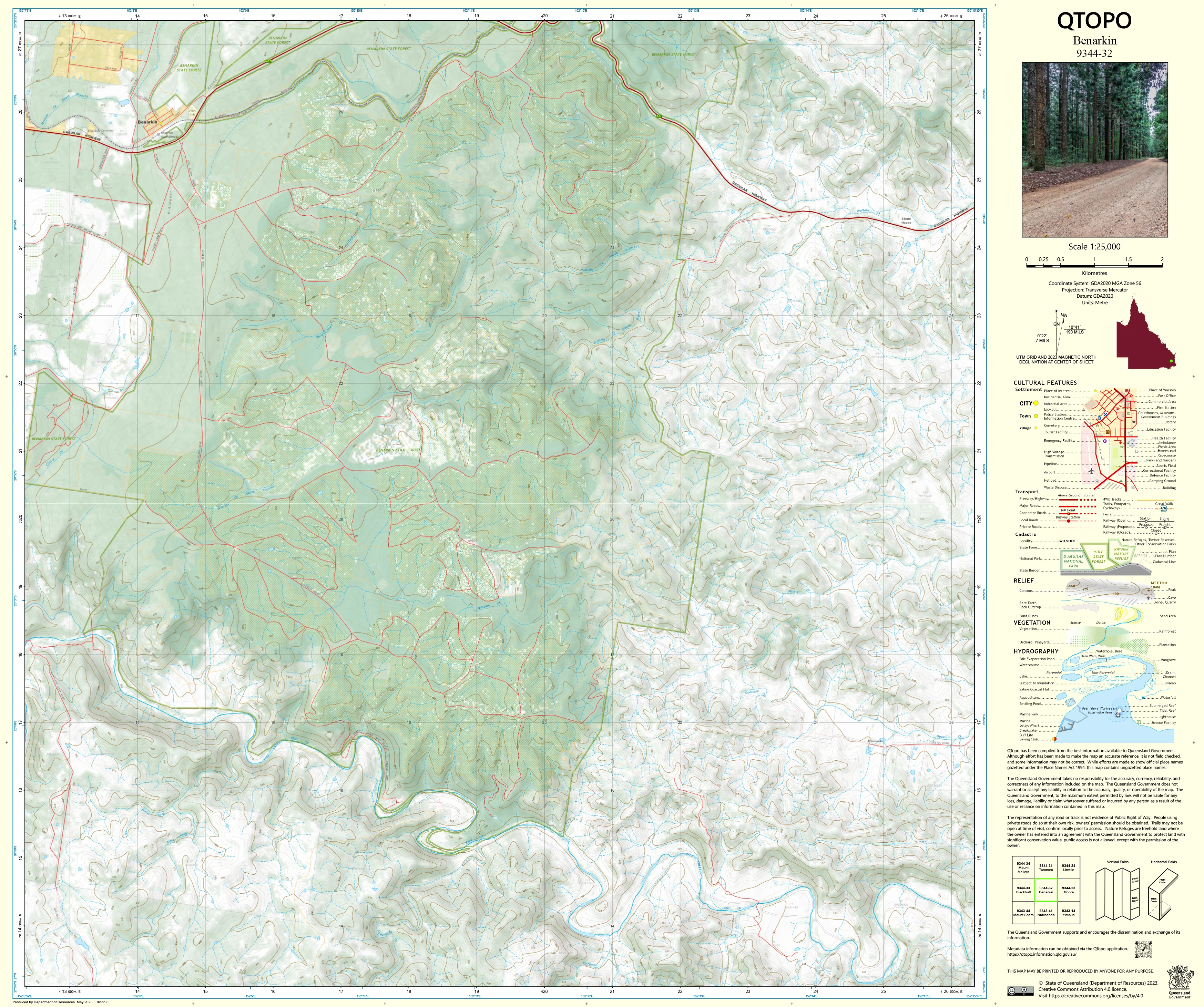
9344-32 Benarkin QTopo 1:25,000 Topographic Map
QTopo 9344-32 — Benarkin
1:25,000 Topographic Map
A detailed and reliable topographic map covering the Benarkin region—an area defined by expansive state forests, rugged timbered hills, deep creek systems, and well-established forestry and grazing country on Queensland’s South Burnett fringe. With its mixture of plantation forest, native woodland, steep gullies, and rural access tracks, Benarkin is a landscape where accurate and dependable mapping is essential.
The QTopo 9344-32 (Benarkin) sheet—produced by the Queensland Department of Resources—is part of the authoritative 1:25,000 topographic mapping series. It delivers high-resolution terrain modelling, hydrology information, vegetation detail, and infrastructure mapping across one of the region’s most heavily forested and operationally significant districts.
Whether you’re navigating forestry trails, conducting ecological surveys, planning grazing operations, or exploring the South Burnett’s remote bushland, QTopo 9344-32 provides the clarity and precision needed for safe and efficient fieldwork.
🗺️ Map Content and Features
At 1:25,000 scale—where 1 cm = 250 m—this map includes:
-
Contour lines showing steep hills, plantation slopes, ridgelines, escarpments, and valley systems
-
Hydrology features: creeks, tributaries, drainage networks, dams, and seasonal watercourses
-
Forestry roads, 4WD tracks & bush access routes covering plantation areas, state forest sections, and rural properties
-
Infrastructure including fencelines, forestry facilities, transmission lines, sheds, and property boundaries
-
Vegetation mapping distinguishing plantation forestry, native forest, woodland, scrub, grassland, and riparian zones
-
Land tenure boundaries: state forest, timber reserves, freehold land, and managed operational areas
-
Named natural features such as ridgelines, creek corridors, hills, and local topographic markers
-
Points of interest for foresters, ecologists, emergency services, and recreational users
Every QTopo sheet is derived from Queensland’s authoritative spatial datasets to ensure accuracy and consistency across the entire mapping series.
🧭 Who Uses This Map?
The Benarkin 9344-32 Topographic Map is widely used by:
-
Forestry operators & plantation managers – operational planning, compartment navigation, access management
-
Environmental scientists & ecologists – habitat survey, vegetation assessment, fauna monitoring
-
Surveyors & land planners – boundary clarification, terrain analysis, development planning
-
Rangers & land managers – managing state forest assets and monitoring land conditions
-
Emergency services & SES – incident planning, search & rescue, and fire response
-
4WD drivers, hikers & bush explorers – navigating forest trails and remote bushland
-
Educators & students – topographic interpretation, landform study, and field skills
A reliable resource for both operational and recreational navigation.
💧 Field-Ready Options for Forest & Backcountry Terrain
Choose a finish suited to Benarkin’s rugged slopes, dense canopy cover, and variable weather.
✅ Waterproof & Tearproof Tyvek®
-
Printed on DuPont™ Tyvek®
-
Fully waterproof, tear-resistant, lightweight, and robust
-
Ideal for forestry, bushwalking, and high-use fieldwork
✅ Laminated Edition
-
Encapsulated in 2 × 80-micron gloss laminate
-
Writeable surface compatible with whiteboard markers
-
Wipe-clean and resistant to moisture, mud, dust, and abrasion
📄 Standard Paper Edition
-
Sharp, high-resolution printing
-
Ideal for office reference, planning, and occasional field use
📐 Map Details
Title: QTopo 9344-32 — Benarkin
Publisher: Queensland Department of Resources
Series: QTopo 1:25,000
Scale: 1:25,000 (1 cm = 250 m)
Dimensions: 710 mm (width) × 594 mm (height)
Coverage: Benarkin State Forest, surrounding plantation areas, creek systems, ridgelines, rural holdings, and local access routes
Material Options: Paper, laminated, or waterproof Tyvek®
Printed in: Australia
Edition: Latest available (see listing for publication year)
📥 QTopo Map Index
Need adjoining South Burnett or Brisbane Valley sheets?
➡️ Provide nearby sheet numbers—such as 9344-31, 9344-33, or 9444-02—and I’ll identify the adjoining maps instantly.
🛒 Ordering & Options
-
Standard folded paper map – perfect for planning and general reference
-
Tyvek® waterproof edition – built for forestry, rugged terrain, and high-use outdoor conditions
-
Laminated edition – durable, reusable, and ideal for operational mapping
-
Flat (unfolded) maps available for wall or workspace display
🎯 Summary
The QTopo 9344-32 — Benarkin Topographic Map provides essential detail on terrain, hydrology, vegetation, access routes, and land use across one of Queensland’s most significant forestry and backcountry regions. With high-quality 1:25,000 mapping and tough print options, it is indispensable for foresters, ecologists, surveyors, emergency responders, and off-road explorers.
Plan with purpose.
Navigate with confidence.
Explore with clarity.
Choose your preferred finish today and take Benarkin into the field with Queensland’s most dependable topographic mapping.
Original: $14.27
-65%$14.27
$4.99Product Information
Product Information
Shipping & Returns
Shipping & Returns
Description
QTopo 9344-32 — Benarkin
1:25,000 Topographic Map
A detailed and reliable topographic map covering the Benarkin region—an area defined by expansive state forests, rugged timbered hills, deep creek systems, and well-established forestry and grazing country on Queensland’s South Burnett fringe. With its mixture of plantation forest, native woodland, steep gullies, and rural access tracks, Benarkin is a landscape where accurate and dependable mapping is essential.
The QTopo 9344-32 (Benarkin) sheet—produced by the Queensland Department of Resources—is part of the authoritative 1:25,000 topographic mapping series. It delivers high-resolution terrain modelling, hydrology information, vegetation detail, and infrastructure mapping across one of the region’s most heavily forested and operationally significant districts.
Whether you’re navigating forestry trails, conducting ecological surveys, planning grazing operations, or exploring the South Burnett’s remote bushland, QTopo 9344-32 provides the clarity and precision needed for safe and efficient fieldwork.
🗺️ Map Content and Features
At 1:25,000 scale—where 1 cm = 250 m—this map includes:
-
Contour lines showing steep hills, plantation slopes, ridgelines, escarpments, and valley systems
-
Hydrology features: creeks, tributaries, drainage networks, dams, and seasonal watercourses
-
Forestry roads, 4WD tracks & bush access routes covering plantation areas, state forest sections, and rural properties
-
Infrastructure including fencelines, forestry facilities, transmission lines, sheds, and property boundaries
-
Vegetation mapping distinguishing plantation forestry, native forest, woodland, scrub, grassland, and riparian zones
-
Land tenure boundaries: state forest, timber reserves, freehold land, and managed operational areas
-
Named natural features such as ridgelines, creek corridors, hills, and local topographic markers
-
Points of interest for foresters, ecologists, emergency services, and recreational users
Every QTopo sheet is derived from Queensland’s authoritative spatial datasets to ensure accuracy and consistency across the entire mapping series.
🧭 Who Uses This Map?
The Benarkin 9344-32 Topographic Map is widely used by:
-
Forestry operators & plantation managers – operational planning, compartment navigation, access management
-
Environmental scientists & ecologists – habitat survey, vegetation assessment, fauna monitoring
-
Surveyors & land planners – boundary clarification, terrain analysis, development planning
-
Rangers & land managers – managing state forest assets and monitoring land conditions
-
Emergency services & SES – incident planning, search & rescue, and fire response
-
4WD drivers, hikers & bush explorers – navigating forest trails and remote bushland
-
Educators & students – topographic interpretation, landform study, and field skills
A reliable resource for both operational and recreational navigation.
💧 Field-Ready Options for Forest & Backcountry Terrain
Choose a finish suited to Benarkin’s rugged slopes, dense canopy cover, and variable weather.
✅ Waterproof & Tearproof Tyvek®
-
Printed on DuPont™ Tyvek®
-
Fully waterproof, tear-resistant, lightweight, and robust
-
Ideal for forestry, bushwalking, and high-use fieldwork
✅ Laminated Edition
-
Encapsulated in 2 × 80-micron gloss laminate
-
Writeable surface compatible with whiteboard markers
-
Wipe-clean and resistant to moisture, mud, dust, and abrasion
📄 Standard Paper Edition
-
Sharp, high-resolution printing
-
Ideal for office reference, planning, and occasional field use
📐 Map Details
Title: QTopo 9344-32 — Benarkin
Publisher: Queensland Department of Resources
Series: QTopo 1:25,000
Scale: 1:25,000 (1 cm = 250 m)
Dimensions: 710 mm (width) × 594 mm (height)
Coverage: Benarkin State Forest, surrounding plantation areas, creek systems, ridgelines, rural holdings, and local access routes
Material Options: Paper, laminated, or waterproof Tyvek®
Printed in: Australia
Edition: Latest available (see listing for publication year)
📥 QTopo Map Index
Need adjoining South Burnett or Brisbane Valley sheets?
➡️ Provide nearby sheet numbers—such as 9344-31, 9344-33, or 9444-02—and I’ll identify the adjoining maps instantly.
🛒 Ordering & Options
-
Standard folded paper map – perfect for planning and general reference
-
Tyvek® waterproof edition – built for forestry, rugged terrain, and high-use outdoor conditions
-
Laminated edition – durable, reusable, and ideal for operational mapping
-
Flat (unfolded) maps available for wall or workspace display
🎯 Summary
The QTopo 9344-32 — Benarkin Topographic Map provides essential detail on terrain, hydrology, vegetation, access routes, and land use across one of Queensland’s most significant forestry and backcountry regions. With high-quality 1:25,000 mapping and tough print options, it is indispensable for foresters, ecologists, surveyors, emergency responders, and off-road explorers.
Plan with purpose.
Navigate with confidence.
Explore with clarity.
Choose your preferred finish today and take Benarkin into the field with Queensland’s most dependable topographic mapping.


