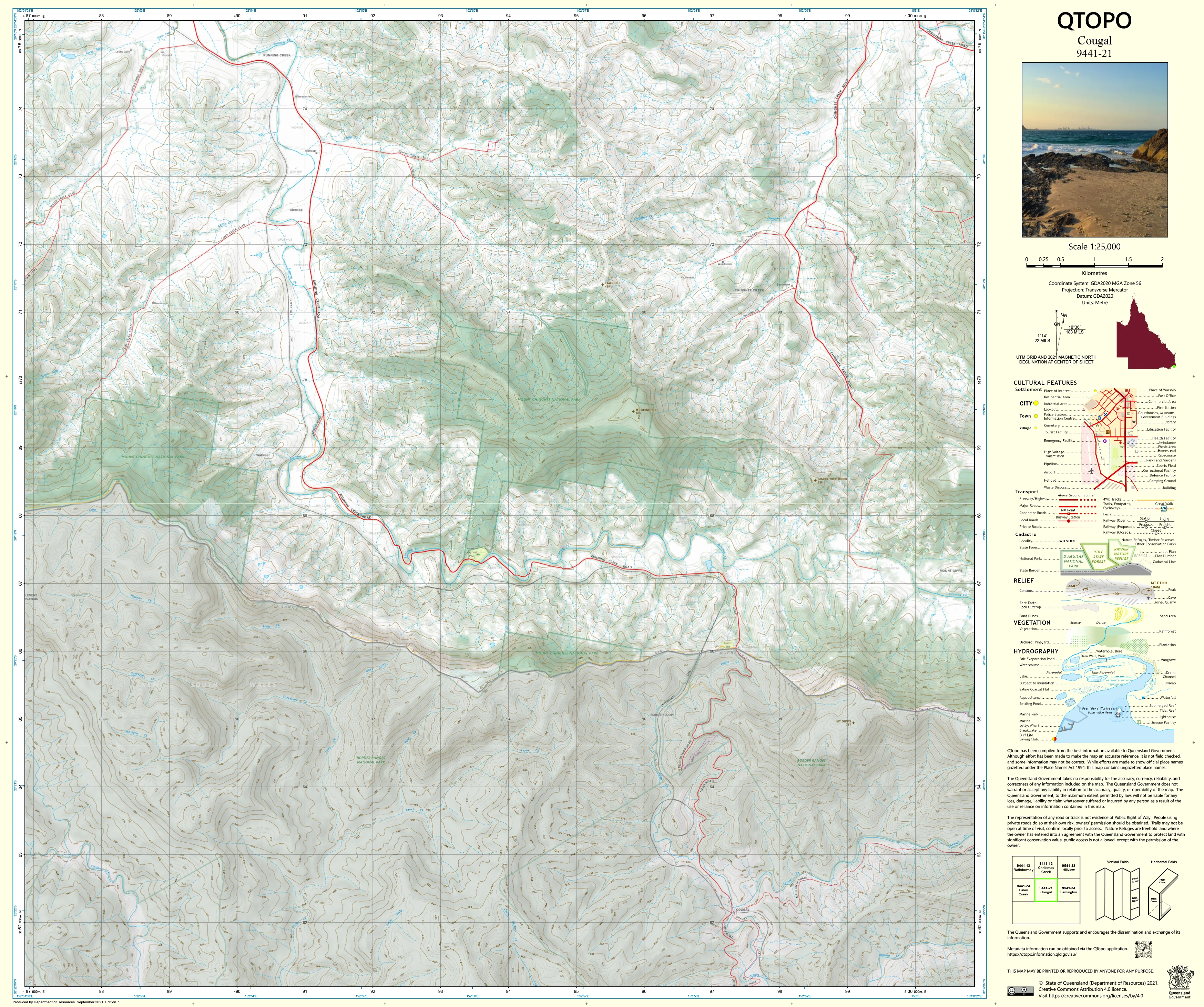
9441-21 Cougal QTopo 1:25,000 Topographic Map
QTopo 9441-21 — Cougal
1:25,000 Topographic Map
A detailed, high-accuracy topographic map covering the rugged Cougal region—an area dominated by steep volcanic mountains, deeply incised rainforest valleys, narrow ridge systems, and remote state border terrain within the eastern McPherson Range. With its dramatic escarpments, dense vegetation, and challenging access, this is a landscape where precision mapping is essential for safety, conservation, and professional fieldwork.
The QTopo 9441-21 (Cougal) sheet—produced by the Queensland Department of Resources—forms part of the authoritative 1:25,000 statewide mapping series. It provides precise elevation modelling, hydrology detail, vegetation structure, and access information across one of Queensland’s most environmentally significant and topographically complex mountain regions.
Whether you're navigating remote ridgelines, conducting ecological surveys, undertaking border-country patrols, or exploring rainforest wilderness, QTopo 9441-21 delivers the clarity and reliability needed for informed decision-making in steep, high-relief terrain.
🗺️ Map Content and Features
At 1:25,000 scale—where 1 cm = 250 m—this map includes:
-
Contour lines showing steep volcanic peaks, escarpments, spurs, cliffs, saddle points, and valley systems
-
Hydrology features: perennial creeks, waterfalls, gorge systems, drainage lines, and upper catchment tributaries
-
Bushwalking routes, ridge access paths & remote terrain features used by rangers, ecologists, and experienced explorers
-
Infrastructure including fencelines, access points, communication installations, and border markers
-
Vegetation mapping detailing rainforest, wet sclerophyll forest, woodland, scrub, and riparian ecosystems
-
Land tenure boundaries: national park, conservation zones, state forest, and adjacent freehold parcels
-
Named topographic features including Cougal, surrounding peaks, ridge networks, creek corridors, and scenic vantage points
-
Points of interest for emergency services, field researchers, surveyors, and advanced bushwalkers
All QTopo maps are derived from Queensland’s authoritative spatial datasets to ensure accuracy and consistency.
🧭 Who Uses This Map?
The Cougal 9441-21 Topographic Map is commonly used by:
-
Environmental scientists & ecologists – rainforest surveys, species monitoring, habitat research
-
Surveyors & planners – border-country terrain assessment, boundary interpretation
-
Rangers & conservation officers – managing protected areas and regulating remote access
-
Emergency services & SES – search & rescue, helicopter access planning, fire management
-
Experienced hikers & bushwalkers – navigating steep ridgelines, dense forest, and remote high country
-
Outdoor educators – teaching advanced navigation in rugged, rainforest-dominated terrain
A trusted tool for both professional fieldwork and advanced recreational use.
💧 Field-Ready Options for Steep Mountain & Rainforest Terrain
Choose a print finish built for Cougal’s wet climate, dense canopy cover, and rugged relief.
✅ Waterproof & Tearproof Tyvek®
-
Printed on DuPont™ Tyvek®
-
Completely waterproof, tear-resistant, and extremely durable
-
Designed for all-weather rainforest fieldwork and repeated folding
✅ Laminated Edition
-
Encapsulated in 2 × 80-micron gloss laminate
-
Writeable surface compatible with whiteboard markers
-
Resistant to moisture, mud, abrasion, and heavy handling
📄 Standard Paper Edition
-
Crisp, high-resolution printing
-
Suitable for planning, study, and occasional outdoor reference
📐 Map Details
Title: QTopo 9441-21 — Cougal
Publisher: Queensland Department of Resources
Series: QTopo 1:25,000
Scale: 1:25,000 (1 cm = 250 m)
Dimensions: 710 mm (width) × 594 mm (height)
Coverage: Cougal, McPherson Range peaks, rainforest valleys, border ridgelines, creek systems, and remote mountain terrain
Material Options: Paper, laminated, or waterproof Tyvek®
Printed in: Australia
Edition: Latest available (see listing for publication year)
📥 QTopo Map Index
Need neighbouring border-country or Scenic Rim sheets?
➡️ Provide nearby sheet numbers—such as 9441-11, 9441-22, or 9341-12—and I’ll identify the correct adjoining maps instantly.
🛒 Ordering & Options
-
Standard folded paper map – perfect for planning, research, and general reference
-
Tyvek® waterproof edition – ideal for rainforest, border-country, and all-weather fieldwork
-
Laminated edition – durable, reusable, and suitable for operational or instructional use
-
Flat (unfolded) maps available for wall or workstation display
🎯 Summary
The QTopo 9441-21 — Cougal Topographic Map provides precise detail on terrain, water systems, vegetation, access, and land classification across one of Queensland’s steepest and most ecologically significant mountain regions. With authoritative 1:25,000 mapping and rugged print options, it is indispensable for ecologists, surveyors, rangers, emergency responders, and experienced wilderness explorers.
Plan with purpose.
Navigate with confidence.
Explore with clarity.
Choose your preferred finish today and take Cougal into the field with Queensland’s most dependable topographic mapping.
Original: $14.27
-65%$14.27
$4.99Product Information
Product Information
Shipping & Returns
Shipping & Returns
Description
QTopo 9441-21 — Cougal
1:25,000 Topographic Map
A detailed, high-accuracy topographic map covering the rugged Cougal region—an area dominated by steep volcanic mountains, deeply incised rainforest valleys, narrow ridge systems, and remote state border terrain within the eastern McPherson Range. With its dramatic escarpments, dense vegetation, and challenging access, this is a landscape where precision mapping is essential for safety, conservation, and professional fieldwork.
The QTopo 9441-21 (Cougal) sheet—produced by the Queensland Department of Resources—forms part of the authoritative 1:25,000 statewide mapping series. It provides precise elevation modelling, hydrology detail, vegetation structure, and access information across one of Queensland’s most environmentally significant and topographically complex mountain regions.
Whether you're navigating remote ridgelines, conducting ecological surveys, undertaking border-country patrols, or exploring rainforest wilderness, QTopo 9441-21 delivers the clarity and reliability needed for informed decision-making in steep, high-relief terrain.
🗺️ Map Content and Features
At 1:25,000 scale—where 1 cm = 250 m—this map includes:
-
Contour lines showing steep volcanic peaks, escarpments, spurs, cliffs, saddle points, and valley systems
-
Hydrology features: perennial creeks, waterfalls, gorge systems, drainage lines, and upper catchment tributaries
-
Bushwalking routes, ridge access paths & remote terrain features used by rangers, ecologists, and experienced explorers
-
Infrastructure including fencelines, access points, communication installations, and border markers
-
Vegetation mapping detailing rainforest, wet sclerophyll forest, woodland, scrub, and riparian ecosystems
-
Land tenure boundaries: national park, conservation zones, state forest, and adjacent freehold parcels
-
Named topographic features including Cougal, surrounding peaks, ridge networks, creek corridors, and scenic vantage points
-
Points of interest for emergency services, field researchers, surveyors, and advanced bushwalkers
All QTopo maps are derived from Queensland’s authoritative spatial datasets to ensure accuracy and consistency.
🧭 Who Uses This Map?
The Cougal 9441-21 Topographic Map is commonly used by:
-
Environmental scientists & ecologists – rainforest surveys, species monitoring, habitat research
-
Surveyors & planners – border-country terrain assessment, boundary interpretation
-
Rangers & conservation officers – managing protected areas and regulating remote access
-
Emergency services & SES – search & rescue, helicopter access planning, fire management
-
Experienced hikers & bushwalkers – navigating steep ridgelines, dense forest, and remote high country
-
Outdoor educators – teaching advanced navigation in rugged, rainforest-dominated terrain
A trusted tool for both professional fieldwork and advanced recreational use.
💧 Field-Ready Options for Steep Mountain & Rainforest Terrain
Choose a print finish built for Cougal’s wet climate, dense canopy cover, and rugged relief.
✅ Waterproof & Tearproof Tyvek®
-
Printed on DuPont™ Tyvek®
-
Completely waterproof, tear-resistant, and extremely durable
-
Designed for all-weather rainforest fieldwork and repeated folding
✅ Laminated Edition
-
Encapsulated in 2 × 80-micron gloss laminate
-
Writeable surface compatible with whiteboard markers
-
Resistant to moisture, mud, abrasion, and heavy handling
📄 Standard Paper Edition
-
Crisp, high-resolution printing
-
Suitable for planning, study, and occasional outdoor reference
📐 Map Details
Title: QTopo 9441-21 — Cougal
Publisher: Queensland Department of Resources
Series: QTopo 1:25,000
Scale: 1:25,000 (1 cm = 250 m)
Dimensions: 710 mm (width) × 594 mm (height)
Coverage: Cougal, McPherson Range peaks, rainforest valleys, border ridgelines, creek systems, and remote mountain terrain
Material Options: Paper, laminated, or waterproof Tyvek®
Printed in: Australia
Edition: Latest available (see listing for publication year)
📥 QTopo Map Index
Need neighbouring border-country or Scenic Rim sheets?
➡️ Provide nearby sheet numbers—such as 9441-11, 9441-22, or 9341-12—and I’ll identify the correct adjoining maps instantly.
🛒 Ordering & Options
-
Standard folded paper map – perfect for planning, research, and general reference
-
Tyvek® waterproof edition – ideal for rainforest, border-country, and all-weather fieldwork
-
Laminated edition – durable, reusable, and suitable for operational or instructional use
-
Flat (unfolded) maps available for wall or workstation display
🎯 Summary
The QTopo 9441-21 — Cougal Topographic Map provides precise detail on terrain, water systems, vegetation, access, and land classification across one of Queensland’s steepest and most ecologically significant mountain regions. With authoritative 1:25,000 mapping and rugged print options, it is indispensable for ecologists, surveyors, rangers, emergency responders, and experienced wilderness explorers.
Plan with purpose.
Navigate with confidence.
Explore with clarity.
Choose your preferred finish today and take Cougal into the field with Queensland’s most dependable topographic mapping.


