9441-24 Palen Creek QTopo 1:25,000 Topographic Map
QTopo 9441-24 — Palen Creek
1:25,000 Topographic Map
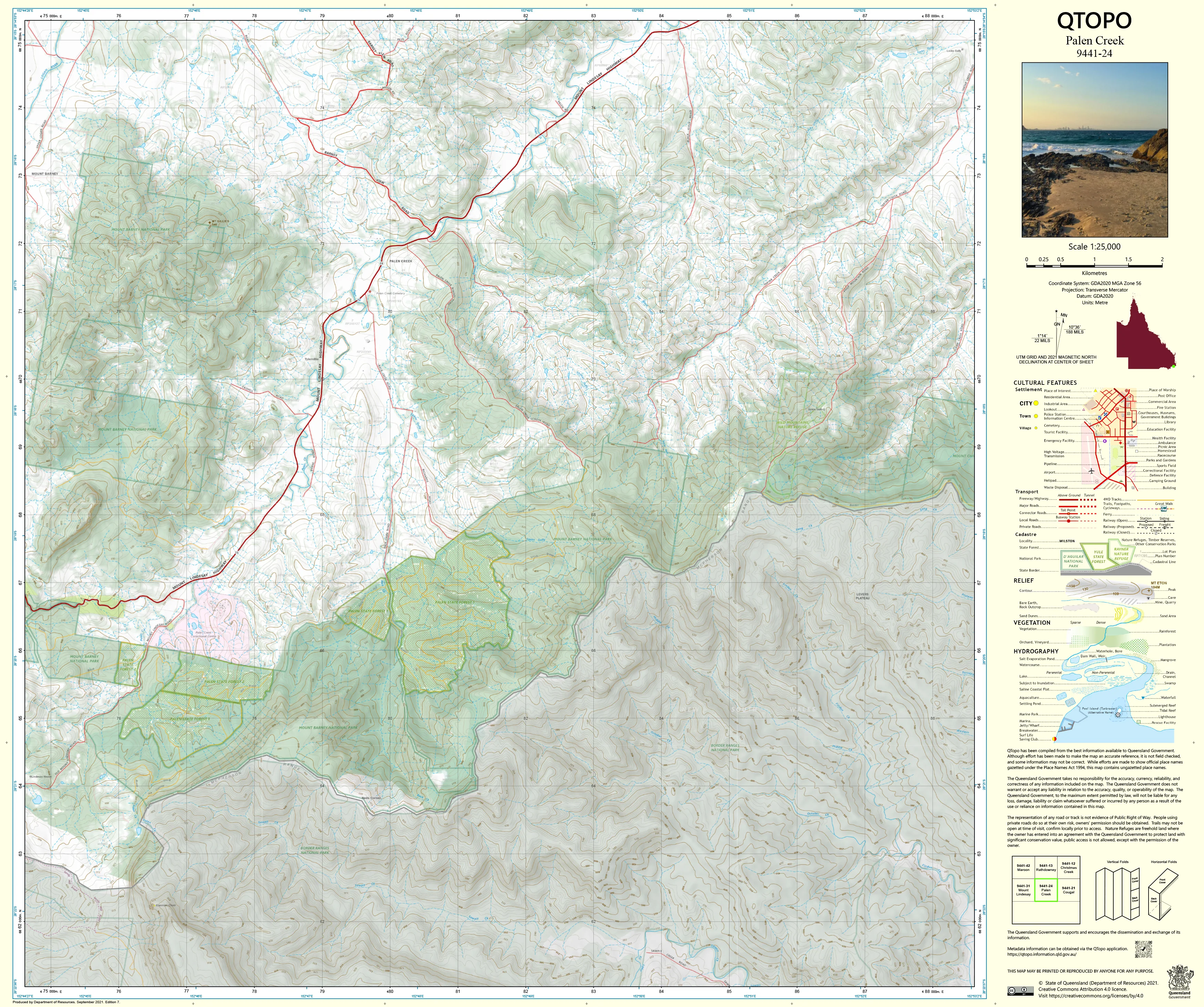
A high-precision topographic map covering the Palen Creek region—an area of rugged border-country terrain marked by steep volcanic ridges, forested foothills, productive farmland, and the winding upper reaches of Palen Creek itself. Situated along the Queensland–New South Wales boundary, this landscape combines dramatic elevation changes with rich agricultural valleys, making accurate mapping essential for landholders, conservationists, and field navigators.
The QTopo 9441-24 (Palen Creek) sheet—produced by the Queensland Department of Resources—forms part of the authoritative 1:25,000 statewide mapping series. It provides detailed elevation modelling, hydrology mapping, vegetation classification, and infrastructure layout across one of the Scenic Rim’s most diverse and environmentally significant districts.
Whether you’re surveying steep bush-covered ridgelines, managing rural properties, conducting ecological fieldwork, or navigating cross-border terrain, QTopo 9441-24 delivers the accuracy and clarity required for confident on-ground decision-making.
🗺️ Map Content and Features
At 1:25,000 scale—where 1 cm = 250 m—this map includes:
-
Contour lines depicting volcanic hills, forested ridges, escarpments, gullies, and rolling valley floors
-
Hydrology features: Palen Creek, tributaries, drainage lines, dams, waterholes, and seasonal flows
-
Roads, property tracks & rural access routes linking farms, homesteads, park boundaries, and neighbouring communities
-
Infrastructure including fencelines, powerlines, communication towers, sheds, and agricultural facilities
-
Vegetation mapping covering rainforest edges, eucalypt forest, plantation areas, woodland, scrub, and riparian zones
-
Land tenure boundaries: national park, conservation zones, forest reserves, freehold land, and state-managed parcels
-
Named natural features including hills, creek corridors, lookout points, ridgelines, and border terrain markers
-
Points of interest for surveyors, ecologists, rangers, emergency services, and experienced hikers
All QTopo maps are derived from Queensland’s authoritative spatial datasets, ensuring accuracy and consistency across the entire series.
🧭 Who Uses This Map?
The Palen Creek 9441-24 Topographic Map is widely used by:
-
Graziers & agricultural operators – paddock planning, water management, and property mapping
-
Environmental scientists & ecologists – biodiversity surveys, vegetation mapping, habitat assessment
-
Surveyors & planners – boundary interpretation, terrain modelling, rural development planning
-
Rangers & conservation officers – monitoring national parks, forest reserves, and access corridors
-
Emergency services & SES – flood modelling, search & rescue, and bushfire response
-
Bushwalkers & remote explorers – navigating border ridgelines, valleys, and forest tracks
A trusted resource for both professional and advanced recreational use.
💧 Field-Ready Options for Rural, Forest & Border Terrain
Choose a print finish suited to Palen Creek’s varied mixture of farmland, foothills, and cross-border mountain country.
✅ Waterproof & Tearproof Tyvek®
-
Printed on DuPont™ Tyvek®
-
Completely waterproof, tear-resistant, and lightweight
-
Ideal for all-weather field operations and rugged terrain
✅ Laminated Edition
-
Encapsulated in 2 × 80-micron gloss laminate
-
Writeable surface usable with whiteboard markers
-
Wipe-clean and resistant to moisture, mud, dust, and abrasion
📄 Standard Paper Edition
-
High-resolution, crisp print
-
Suitable for planning, study, and occasional outdoor reference
📐 Map Details
Title: QTopo 9441-24 — Palen Creek
Publisher: Queensland Department of Resources
Series: QTopo 1:25,000
Scale: 1:25,000 (1 cm = 250 m)
Dimensions: 710 mm (width) × 594 mm (height)
Coverage: Palen Creek, surrounding valley systems, volcanic foothills, forested ridges, farmland, and border terrain
Material Options: Paper, laminated, or waterproof Tyvek®
Printed in: Australia
Edition: Latest available (see listing for publication year)
📥 QTopo Map Index
Need adjoining Scenic Rim or border-country sheets?
➡️ Provide nearby sheet numbers—such as 9441-23, 9441-25, or 9341-22—and I’ll identify the adjoining maps instantly.
🛒 Ordering & Options
-
Standard folded paper map – ideal for planning and general reference
-
Tyvek® waterproof edition – perfect for rugged, all-weather fieldwork
-
Laminated edition – durable, reusable, and excellent for operational use
-
Flat (unfolded) maps available for wall or workspace display
🎯 Summary
The QTopo 9441-24 — Palen Creek Topographic Map provides essential detail on terrain, hydrology, vegetation, access routes, and land-use distribution across a diverse mix of farmland, foothills, and rugged border-country terrain. With authoritative 1:25,000 mapping and durable print options, it is indispensable for ecologists, farmers, surveyors, emergency responders, and experienced bushwalkers.
Plan with purpose.
Navigate with confidence.
Explore with clarity.
Choose your preferred finish today and take Palen Creek into the field with Queensland’s most trusted topographic mapping.
Original: $14.27
-65%$14.27
$4.99Product Information
Product Information
Shipping & Returns
Shipping & Returns
Description
QTopo 9441-24 — Palen Creek
1:25,000 Topographic Map
A high-precision topographic map covering the Palen Creek region—an area of rugged border-country terrain marked by steep volcanic ridges, forested foothills, productive farmland, and the winding upper reaches of Palen Creek itself. Situated along the Queensland–New South Wales boundary, this landscape combines dramatic elevation changes with rich agricultural valleys, making accurate mapping essential for landholders, conservationists, and field navigators.
The QTopo 9441-24 (Palen Creek) sheet—produced by the Queensland Department of Resources—forms part of the authoritative 1:25,000 statewide mapping series. It provides detailed elevation modelling, hydrology mapping, vegetation classification, and infrastructure layout across one of the Scenic Rim’s most diverse and environmentally significant districts.
Whether you’re surveying steep bush-covered ridgelines, managing rural properties, conducting ecological fieldwork, or navigating cross-border terrain, QTopo 9441-24 delivers the accuracy and clarity required for confident on-ground decision-making.
🗺️ Map Content and Features
At 1:25,000 scale—where 1 cm = 250 m—this map includes:
-
Contour lines depicting volcanic hills, forested ridges, escarpments, gullies, and rolling valley floors
-
Hydrology features: Palen Creek, tributaries, drainage lines, dams, waterholes, and seasonal flows
-
Roads, property tracks & rural access routes linking farms, homesteads, park boundaries, and neighbouring communities
-
Infrastructure including fencelines, powerlines, communication towers, sheds, and agricultural facilities
-
Vegetation mapping covering rainforest edges, eucalypt forest, plantation areas, woodland, scrub, and riparian zones
-
Land tenure boundaries: national park, conservation zones, forest reserves, freehold land, and state-managed parcels
-
Named natural features including hills, creek corridors, lookout points, ridgelines, and border terrain markers
-
Points of interest for surveyors, ecologists, rangers, emergency services, and experienced hikers
All QTopo maps are derived from Queensland’s authoritative spatial datasets, ensuring accuracy and consistency across the entire series.
🧭 Who Uses This Map?
The Palen Creek 9441-24 Topographic Map is widely used by:
-
Graziers & agricultural operators – paddock planning, water management, and property mapping
-
Environmental scientists & ecologists – biodiversity surveys, vegetation mapping, habitat assessment
-
Surveyors & planners – boundary interpretation, terrain modelling, rural development planning
-
Rangers & conservation officers – monitoring national parks, forest reserves, and access corridors
-
Emergency services & SES – flood modelling, search & rescue, and bushfire response
-
Bushwalkers & remote explorers – navigating border ridgelines, valleys, and forest tracks
A trusted resource for both professional and advanced recreational use.
💧 Field-Ready Options for Rural, Forest & Border Terrain
Choose a print finish suited to Palen Creek’s varied mixture of farmland, foothills, and cross-border mountain country.
✅ Waterproof & Tearproof Tyvek®
-
Printed on DuPont™ Tyvek®
-
Completely waterproof, tear-resistant, and lightweight
-
Ideal for all-weather field operations and rugged terrain
✅ Laminated Edition
-
Encapsulated in 2 × 80-micron gloss laminate
-
Writeable surface usable with whiteboard markers
-
Wipe-clean and resistant to moisture, mud, dust, and abrasion
📄 Standard Paper Edition
-
High-resolution, crisp print
-
Suitable for planning, study, and occasional outdoor reference
📐 Map Details
Title: QTopo 9441-24 — Palen Creek
Publisher: Queensland Department of Resources
Series: QTopo 1:25,000
Scale: 1:25,000 (1 cm = 250 m)
Dimensions: 710 mm (width) × 594 mm (height)
Coverage: Palen Creek, surrounding valley systems, volcanic foothills, forested ridges, farmland, and border terrain
Material Options: Paper, laminated, or waterproof Tyvek®
Printed in: Australia
Edition: Latest available (see listing for publication year)
📥 QTopo Map Index
Need adjoining Scenic Rim or border-country sheets?
➡️ Provide nearby sheet numbers—such as 9441-23, 9441-25, or 9341-22—and I’ll identify the adjoining maps instantly.
🛒 Ordering & Options
-
Standard folded paper map – ideal for planning and general reference
-
Tyvek® waterproof edition – perfect for rugged, all-weather fieldwork
-
Laminated edition – durable, reusable, and excellent for operational use
-
Flat (unfolded) maps available for wall or workspace display
🎯 Summary
The QTopo 9441-24 — Palen Creek Topographic Map provides essential detail on terrain, hydrology, vegetation, access routes, and land-use distribution across a diverse mix of farmland, foothills, and rugged border-country terrain. With authoritative 1:25,000 mapping and durable print options, it is indispensable for ecologists, farmers, surveyors, emergency responders, and experienced bushwalkers.
Plan with purpose.
Navigate with confidence.
Explore with clarity.
Choose your preferred finish today and take Palen Creek into the field with Queensland’s most trusted topographic mapping.


