9441-42 Maroon QTopo 1:25,000 Topographic Map
QTopo 9441-42 — Maroon
1:25,000 Topographic Map
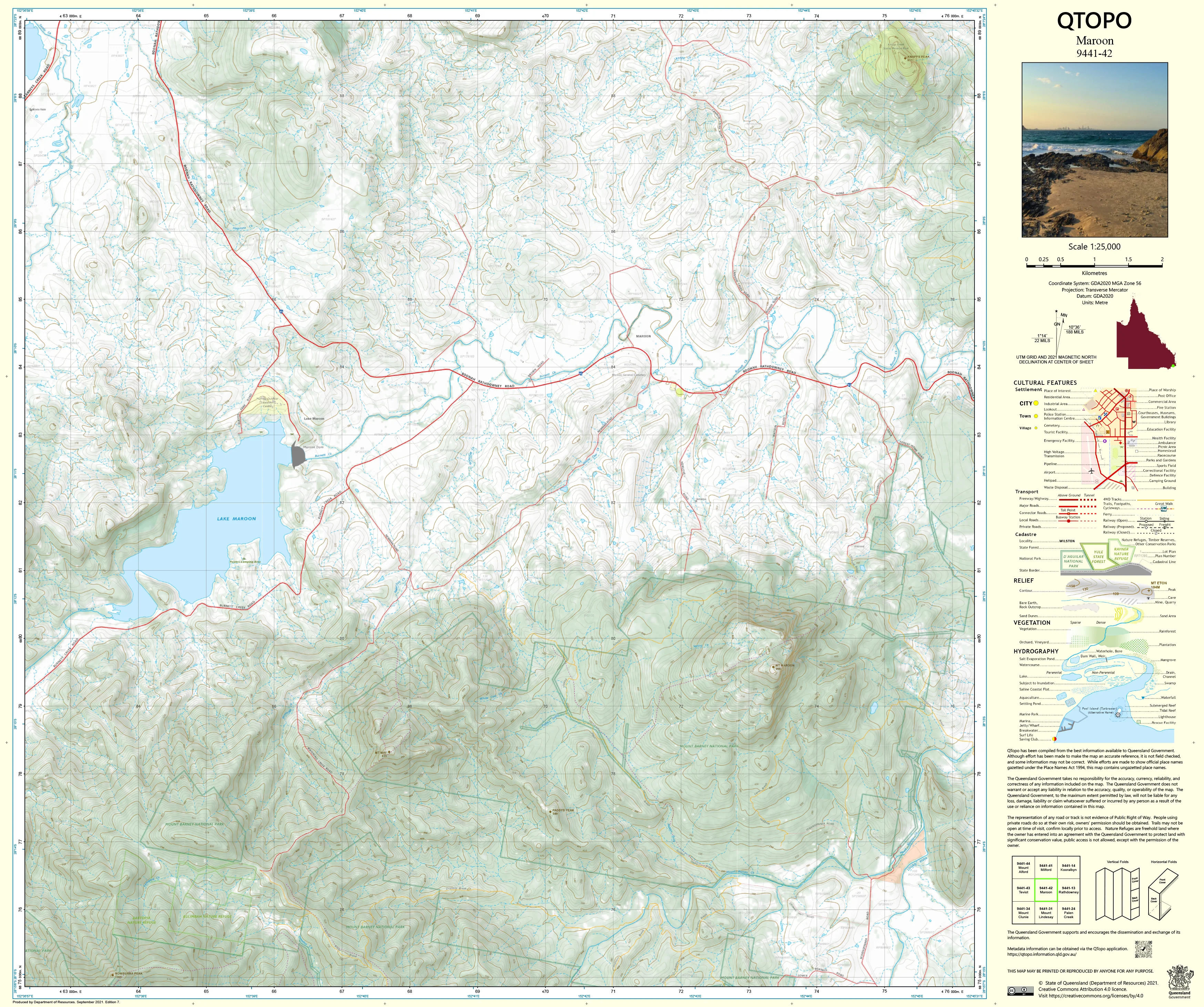
A high-precision topographic map covering the Maroon region—an iconic Scenic Rim landscape characterised by dramatic volcanic peaks, rugged escarpments, rich agricultural valleys, and the expansive waters of Lake Maroon. From steep high-country ridgelines to productive farmland and remote backcountry terrain, this is an area where accurate, detailed mapping is essential for safe navigation, land management, and environmental work.
The QTopo 9441-42 (Maroon) sheet—produced by the Queensland Department of Resources—forms part of Queensland’s authoritative 1:25,000 mapping series. It provides precise elevation modelling, hydrology mapping, vegetation structure, and rural and recreational access detail across one of the Scenic Rim’s most visually striking and widely used outdoor recreation areas.
Whether you’re hiking toward Mount Maroon’s rugged summit, conducting ecological field surveys, planning rural operations, or navigating foothill backroads, QTopo 9441-42 delivers the clarity and accuracy required for confident decision-making.
🗺️ Map Content and Features
At 1:25,000 scale—where 1 cm = 250 m—this map includes:
-
Contour lines showing the steep volcanic slopes of Mount Maroon, rolling foothills, escarpments, and valley systems
-
Hydrology features: Lake Maroon, Maroon Creek, tributaries, drainage networks, waterholes, and seasonal streams
-
Roads, rural access tracks & recreational routes serving farmland, homesteads, camping areas, and trailheads
-
Infrastructure including fencelines, transmission lines, dams, boat ramps, and rural facilities
-
Vegetation mapping showing rainforest remnants, eucalypt forest, woodland, scrub, grassland, and riparian ecosystems
-
Land tenure boundaries: national park, conservation park, state land, and adjacent freehold holdings
-
Named natural features such as Mount Maroon, ridge networks, creek corridors, saddle points, and lookout areas
-
Points of interest for hikers, climbers, ecologists, surveyors, rangers, and emergency responders
Every QTopo sheet uses Queensland’s authoritative spatial datasets, ensuring consistent, high-quality mapping.
🧭 Who Uses This Map?
The Maroon 9441-42 Topographic Map is widely used by:
-
Hikers & rock scramblers – navigating summit routes and high-elevation terrain
-
Environmental scientists & ecologists – flora/fauna surveys, habitat assessment, and fire ecology research
-
Surveyors & land planners – boundary interpretation, terrain modelling, and rural development
-
Rangers & conservation officers – monitoring national parks and regulating recreational access
-
Emergency services & SES – search & rescue, bushfire response, and high-country incident planning
-
Rural landholders & graziers – managing paddocks, water resources, and infrastructure
-
Outdoor educators – teaching navigation and landform interpretation in diverse terrain
A versatile and trusted tool for both professional and recreational users.
💧 Field-Ready Options for Mountain, Valley & Lakeside Environments
Choose a finish suited to Maroon’s steep peaks, open farmland, and wet-season variability.
✅ Waterproof & Tearproof Tyvek®
-
Printed on DuPont™ Tyvek®
-
Completely waterproof, tear-resistant, and lightweight
-
Perfect for rugged mountain hikes, creek crossings, and all-weather fieldwork
✅ Laminated Edition
-
Encapsulated in 2 × 80-micron gloss laminate
-
Writeable surface compatible with whiteboard markers
-
Wipe-clean and resistant to moisture, mud, dust, and repeated handling
📄 Standard Paper Edition
-
High-resolution printing
-
Ideal for planning, study, and occasional field use
📐 Map Details
Title: QTopo 9441-42 — Maroon
Publisher: Queensland Department of Resources
Series: QTopo 1:25,000
Scale: 1:25,000 (1 cm = 250 m)
Dimensions: 710 mm (width) × 594 mm (height)
Coverage: Maroon district including Mount Maroon, Lake Maroon, rolling foothills, creek systems, rural properties, and recreational access areas
Material Options: Paper, laminated, or waterproof Tyvek®
Printed in: Australia
Edition: Latest available (see listing for publication year)
📥 QTopo Map Index
Need adjoining Scenic Rim sheets?
➡️ Provide nearby sheet numbers—such as 9441-32, 9441-41, or 9342-43—and I’ll identify the adjoining maps instantly.
🛒 Ordering & Options
-
Standard folded paper map – ideal for planning, navigation study, and rural reference
-
Tyvek® waterproof edition – excellent for high-country and all-weather adventuring
-
Laminated edition – durable, reusable, and suited to outdoor education and operational use
-
Flat (unfolded) maps available for wall or map-board display
🎯 Summary
The QTopo 9441-42 — Maroon Topographic Map provides essential detail on terrain, hydrology, vegetation, infrastructure, and access across one of the Scenic Rim’s most scenic and varied landscapes. With authoritative 1:25,000 mapping and rugged print options, it is indispensable for hikers, ecologists, surveyors, emergency responders, and rural land managers.
Plan with purpose.
Navigate with confidence.
Explore with clarity.
Choose your preferred finish today and take Maroon into the field with Queensland’s most trusted topographic mapping.
Original: $14.27
-65%$14.27
$4.99Product Information
Product Information
Shipping & Returns
Shipping & Returns
Description
QTopo 9441-42 — Maroon
1:25,000 Topographic Map
A high-precision topographic map covering the Maroon region—an iconic Scenic Rim landscape characterised by dramatic volcanic peaks, rugged escarpments, rich agricultural valleys, and the expansive waters of Lake Maroon. From steep high-country ridgelines to productive farmland and remote backcountry terrain, this is an area where accurate, detailed mapping is essential for safe navigation, land management, and environmental work.
The QTopo 9441-42 (Maroon) sheet—produced by the Queensland Department of Resources—forms part of Queensland’s authoritative 1:25,000 mapping series. It provides precise elevation modelling, hydrology mapping, vegetation structure, and rural and recreational access detail across one of the Scenic Rim’s most visually striking and widely used outdoor recreation areas.
Whether you’re hiking toward Mount Maroon’s rugged summit, conducting ecological field surveys, planning rural operations, or navigating foothill backroads, QTopo 9441-42 delivers the clarity and accuracy required for confident decision-making.
🗺️ Map Content and Features
At 1:25,000 scale—where 1 cm = 250 m—this map includes:
-
Contour lines showing the steep volcanic slopes of Mount Maroon, rolling foothills, escarpments, and valley systems
-
Hydrology features: Lake Maroon, Maroon Creek, tributaries, drainage networks, waterholes, and seasonal streams
-
Roads, rural access tracks & recreational routes serving farmland, homesteads, camping areas, and trailheads
-
Infrastructure including fencelines, transmission lines, dams, boat ramps, and rural facilities
-
Vegetation mapping showing rainforest remnants, eucalypt forest, woodland, scrub, grassland, and riparian ecosystems
-
Land tenure boundaries: national park, conservation park, state land, and adjacent freehold holdings
-
Named natural features such as Mount Maroon, ridge networks, creek corridors, saddle points, and lookout areas
-
Points of interest for hikers, climbers, ecologists, surveyors, rangers, and emergency responders
Every QTopo sheet uses Queensland’s authoritative spatial datasets, ensuring consistent, high-quality mapping.
🧭 Who Uses This Map?
The Maroon 9441-42 Topographic Map is widely used by:
-
Hikers & rock scramblers – navigating summit routes and high-elevation terrain
-
Environmental scientists & ecologists – flora/fauna surveys, habitat assessment, and fire ecology research
-
Surveyors & land planners – boundary interpretation, terrain modelling, and rural development
-
Rangers & conservation officers – monitoring national parks and regulating recreational access
-
Emergency services & SES – search & rescue, bushfire response, and high-country incident planning
-
Rural landholders & graziers – managing paddocks, water resources, and infrastructure
-
Outdoor educators – teaching navigation and landform interpretation in diverse terrain
A versatile and trusted tool for both professional and recreational users.
💧 Field-Ready Options for Mountain, Valley & Lakeside Environments
Choose a finish suited to Maroon’s steep peaks, open farmland, and wet-season variability.
✅ Waterproof & Tearproof Tyvek®
-
Printed on DuPont™ Tyvek®
-
Completely waterproof, tear-resistant, and lightweight
-
Perfect for rugged mountain hikes, creek crossings, and all-weather fieldwork
✅ Laminated Edition
-
Encapsulated in 2 × 80-micron gloss laminate
-
Writeable surface compatible with whiteboard markers
-
Wipe-clean and resistant to moisture, mud, dust, and repeated handling
📄 Standard Paper Edition
-
High-resolution printing
-
Ideal for planning, study, and occasional field use
📐 Map Details
Title: QTopo 9441-42 — Maroon
Publisher: Queensland Department of Resources
Series: QTopo 1:25,000
Scale: 1:25,000 (1 cm = 250 m)
Dimensions: 710 mm (width) × 594 mm (height)
Coverage: Maroon district including Mount Maroon, Lake Maroon, rolling foothills, creek systems, rural properties, and recreational access areas
Material Options: Paper, laminated, or waterproof Tyvek®
Printed in: Australia
Edition: Latest available (see listing for publication year)
📥 QTopo Map Index
Need adjoining Scenic Rim sheets?
➡️ Provide nearby sheet numbers—such as 9441-32, 9441-41, or 9342-43—and I’ll identify the adjoining maps instantly.
🛒 Ordering & Options
-
Standard folded paper map – ideal for planning, navigation study, and rural reference
-
Tyvek® waterproof edition – excellent for high-country and all-weather adventuring
-
Laminated edition – durable, reusable, and suited to outdoor education and operational use
-
Flat (unfolded) maps available for wall or map-board display
🎯 Summary
The QTopo 9441-42 — Maroon Topographic Map provides essential detail on terrain, hydrology, vegetation, infrastructure, and access across one of the Scenic Rim’s most scenic and varied landscapes. With authoritative 1:25,000 mapping and rugged print options, it is indispensable for hikers, ecologists, surveyors, emergency responders, and rural land managers.
Plan with purpose.
Navigate with confidence.
Explore with clarity.
Choose your preferred finish today and take Maroon into the field with Queensland’s most trusted topographic mapping.


