9441-43 Teviot QTopo 1:25,000 Topographic Map
QTopo 9441-43 — Teviot
1:25,000 Topographic Map
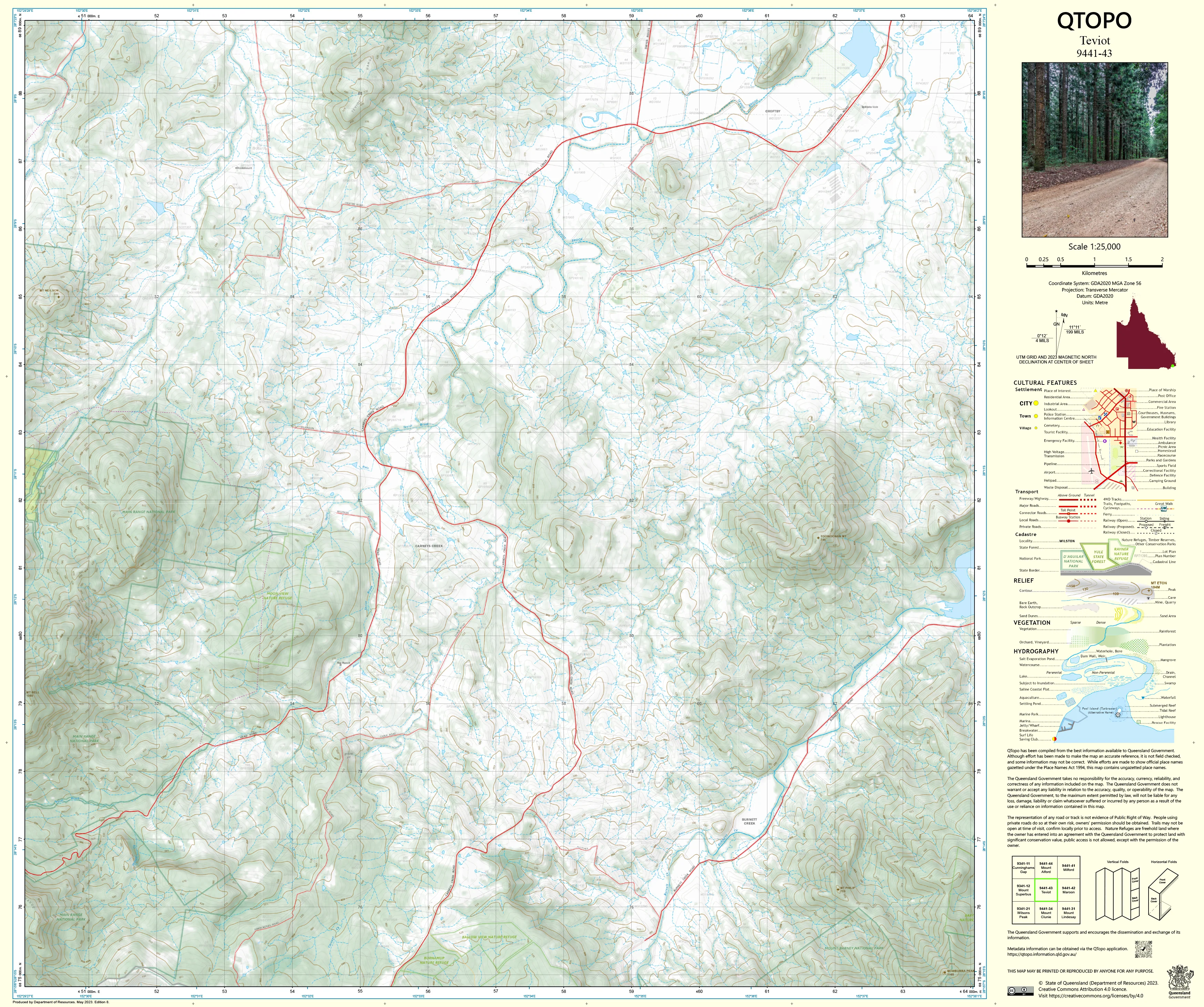
A high-detail topographic map covering the Teviot region—an area defined by steep volcanic foothills, forested ranges, fertile valleys, and the winding upper reaches of Teviot Brook. Set within the eastern Scenic Rim, this landscape blends productive rural holdings with rugged high-country terrain, making accurate mapping essential for land managers, ecologists, adventurers, and emergency personnel.
The QTopo 9441-43 (Teviot) sheet—produced by the Queensland Department of Resources—forms part of the state’s official 1:25,000 mapping series. It provides precise elevation modelling, hydrology detail, vegetation classification, and local infrastructure information across one of the Scenic Rim’s most diverse rural–mountain transition zones.
Whether you're navigating backcountry ridgelines, conducting environmental assessments, responding to rural emergencies, or managing agricultural land, QTopo 9441-43 delivers the clarity and reliability required for confident field operations.
🗺️ Map Content and Features
At 1:25,000 scale—where 1 cm = 250 m—this detailed map includes:
-
Contour lines revealing steep foothills, escarpments, ridges, gullies, and valley floors
-
Hydrology features: Teviot Brook, tributaries, drainage lines, dams, waterholes, and seasonal waterways
-
Roads, property access tracks & 4WD routes connecting farms, homesteads, and forested terrain
-
Infrastructure including fencelines, transmission lines, sheds, pumps, and agricultural facilities
-
Vegetation mapping showing farmland, open woodland, eucalypt forest, scrub, and riparian zones
-
Land tenure boundaries: freehold properties, conservation reserves, state land, and adjacent managed areas
-
Named natural features such as ridgelines, hilltops, creek corridors, saddle points, and scenic viewpoints
-
Points of interest for surveyors, land managers, ecologists, rangers, and emergency services
Every QTopo map is derived from Queensland’s authoritative spatial datasets, ensuring accuracy and consistency across the entire series.
🧭 Who Uses This Map?
The Teviot 9441-43 Topographic Map is widely used by:
-
Graziers & rural operators – paddock planning, water management, and infrastructure layout
-
Environmental scientists & ecologists – fauna/flora surveys, habitat assessment, catchment studies
-
Surveyors & planners – land-use planning, boundary clarification, terrain profiling
-
Rangers & conservation officers – monitoring protected areas and managing access routes
-
Emergency services & SES – flood analysis, wildfire response, rural incident coordination
-
4WD travellers & bushwalkers – navigating rural valleys and semi-remote foothill routes
-
Outdoor educators – teaching landform interpretation and field navigation skills
A versatile and reliable mapping tool for both professional and recreational users.
💧 Field-Ready Options for Rural, Foothill & Creek Corridor Conditions
Choose a finish designed to withstand Teviot’s weather, terrain, and operational demands.
✅ Waterproof & Tearproof Tyvek®
-
Printed on DuPont™ Tyvek®
-
Fully waterproof, tear-resistant, and lightweight
-
Ideal for creek-side fieldwork, wet-season travel, and repeated handling
✅ Laminated Edition
-
Encapsulated in 2 × 80-micron gloss laminate
-
Writeable surface compatible with whiteboard markers
-
Wipe-clean and highly resistant to moisture, dust, mud, and abrasion
📄 Standard Paper Edition
-
Crisp, high-resolution printing
-
Ideal for planning, office use, and occasional field reference
📐 Map Details
Title: QTopo 9441-43 — Teviot
Publisher: Queensland Department of Resources
Series: QTopo 1:25,000
Scale: 1:25,000 (1 cm = 250 m)
Dimensions: 710 mm (width) × 594 mm (height)
Coverage: Teviot Brook catchment, surrounding foothills, ridgelines, rural properties, forest edges, and connected access routes
Material Options: Paper, laminated, or waterproof Tyvek®
Printed in: Australia
Edition: Latest available (see listing for publication year)
📥 QTopo Map Index
Need adjoining Scenic Rim sheets?
➡️ Provide nearby sheet numbers—such as 9441-42, 9441-44, or 9342-43—and I’ll identify the adjoining maps instantly.
🛒 Ordering & Options
-
Standard folded paper map – ideal for planning, reference, and light field use
-
Tyvek® waterproof edition – built for rugged, all-weather outdoor work
-
Laminated edition – durable, reusable, and suited to operational environments
-
Flat (unfolded) maps available for wall or equipment-room display
🎯 Summary
The QTopo 9441-43 — Teviot Topographic Map provides essential detail on terrain, hydrology, vegetation, access routes, and land use across a rich agricultural and foothill region of the Scenic Rim. With accurate 1:25,000 mapping and robust print options, it is indispensable for surveyors, ecologists, rural managers, emergency services, and backcountry travellers.
Plan with purpose.
Navigate with confidence.
Explore with clarity.
Choose your preferred finish today and take Teviot into the field with Queensland’s most trusted topographic mapping.
Original: $28.58
-65%$28.58
$10.00Product Information
Product Information
Shipping & Returns
Shipping & Returns
Description
QTopo 9441-43 — Teviot
1:25,000 Topographic Map
A high-detail topographic map covering the Teviot region—an area defined by steep volcanic foothills, forested ranges, fertile valleys, and the winding upper reaches of Teviot Brook. Set within the eastern Scenic Rim, this landscape blends productive rural holdings with rugged high-country terrain, making accurate mapping essential for land managers, ecologists, adventurers, and emergency personnel.
The QTopo 9441-43 (Teviot) sheet—produced by the Queensland Department of Resources—forms part of the state’s official 1:25,000 mapping series. It provides precise elevation modelling, hydrology detail, vegetation classification, and local infrastructure information across one of the Scenic Rim’s most diverse rural–mountain transition zones.
Whether you're navigating backcountry ridgelines, conducting environmental assessments, responding to rural emergencies, or managing agricultural land, QTopo 9441-43 delivers the clarity and reliability required for confident field operations.
🗺️ Map Content and Features
At 1:25,000 scale—where 1 cm = 250 m—this detailed map includes:
-
Contour lines revealing steep foothills, escarpments, ridges, gullies, and valley floors
-
Hydrology features: Teviot Brook, tributaries, drainage lines, dams, waterholes, and seasonal waterways
-
Roads, property access tracks & 4WD routes connecting farms, homesteads, and forested terrain
-
Infrastructure including fencelines, transmission lines, sheds, pumps, and agricultural facilities
-
Vegetation mapping showing farmland, open woodland, eucalypt forest, scrub, and riparian zones
-
Land tenure boundaries: freehold properties, conservation reserves, state land, and adjacent managed areas
-
Named natural features such as ridgelines, hilltops, creek corridors, saddle points, and scenic viewpoints
-
Points of interest for surveyors, land managers, ecologists, rangers, and emergency services
Every QTopo map is derived from Queensland’s authoritative spatial datasets, ensuring accuracy and consistency across the entire series.
🧭 Who Uses This Map?
The Teviot 9441-43 Topographic Map is widely used by:
-
Graziers & rural operators – paddock planning, water management, and infrastructure layout
-
Environmental scientists & ecologists – fauna/flora surveys, habitat assessment, catchment studies
-
Surveyors & planners – land-use planning, boundary clarification, terrain profiling
-
Rangers & conservation officers – monitoring protected areas and managing access routes
-
Emergency services & SES – flood analysis, wildfire response, rural incident coordination
-
4WD travellers & bushwalkers – navigating rural valleys and semi-remote foothill routes
-
Outdoor educators – teaching landform interpretation and field navigation skills
A versatile and reliable mapping tool for both professional and recreational users.
💧 Field-Ready Options for Rural, Foothill & Creek Corridor Conditions
Choose a finish designed to withstand Teviot’s weather, terrain, and operational demands.
✅ Waterproof & Tearproof Tyvek®
-
Printed on DuPont™ Tyvek®
-
Fully waterproof, tear-resistant, and lightweight
-
Ideal for creek-side fieldwork, wet-season travel, and repeated handling
✅ Laminated Edition
-
Encapsulated in 2 × 80-micron gloss laminate
-
Writeable surface compatible with whiteboard markers
-
Wipe-clean and highly resistant to moisture, dust, mud, and abrasion
📄 Standard Paper Edition
-
Crisp, high-resolution printing
-
Ideal for planning, office use, and occasional field reference
📐 Map Details
Title: QTopo 9441-43 — Teviot
Publisher: Queensland Department of Resources
Series: QTopo 1:25,000
Scale: 1:25,000 (1 cm = 250 m)
Dimensions: 710 mm (width) × 594 mm (height)
Coverage: Teviot Brook catchment, surrounding foothills, ridgelines, rural properties, forest edges, and connected access routes
Material Options: Paper, laminated, or waterproof Tyvek®
Printed in: Australia
Edition: Latest available (see listing for publication year)
📥 QTopo Map Index
Need adjoining Scenic Rim sheets?
➡️ Provide nearby sheet numbers—such as 9441-42, 9441-44, or 9342-43—and I’ll identify the adjoining maps instantly.
🛒 Ordering & Options
-
Standard folded paper map – ideal for planning, reference, and light field use
-
Tyvek® waterproof edition – built for rugged, all-weather outdoor work
-
Laminated edition – durable, reusable, and suited to operational environments
-
Flat (unfolded) maps available for wall or equipment-room display
🎯 Summary
The QTopo 9441-43 — Teviot Topographic Map provides essential detail on terrain, hydrology, vegetation, access routes, and land use across a rich agricultural and foothill region of the Scenic Rim. With accurate 1:25,000 mapping and robust print options, it is indispensable for surveyors, ecologists, rural managers, emergency services, and backcountry travellers.
Plan with purpose.
Navigate with confidence.
Explore with clarity.
Choose your preferred finish today and take Teviot into the field with Queensland’s most trusted topographic mapping.


