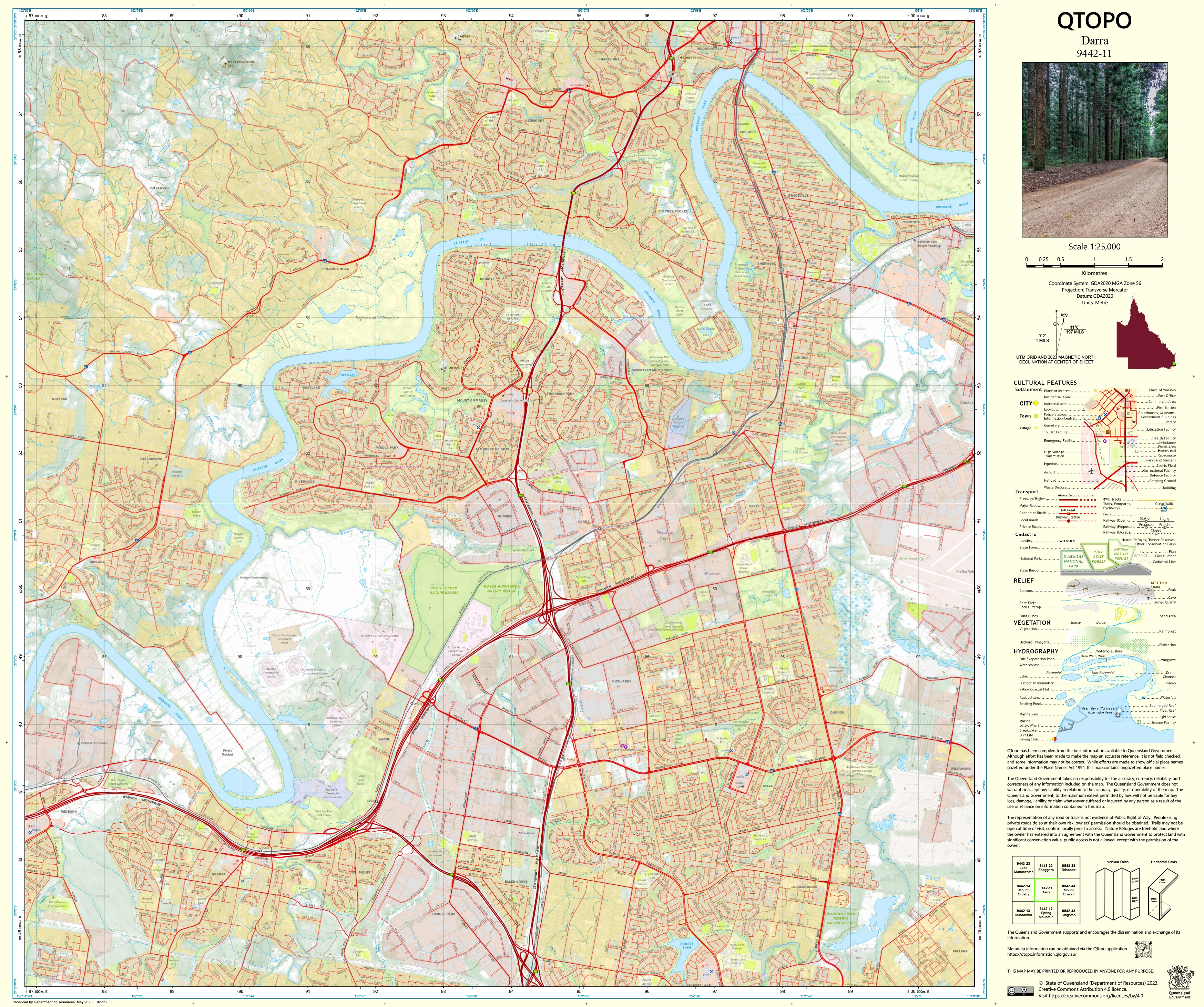
9442-11 Darra QTopo 1:25,000 Topographic Map
QTopo 9442-11 — Darra
1:25,000 Topographic Map
A detailed, high-resolution topographic map covering the Darra region—an urban–industrial corridor of Brisbane known for its major transport routes, suburban neighbourhoods, commercial precincts, creek systems, and expanding residential development. With its mix of built environments, parks, waterways, and industrial infrastructure, Darra is an area where accurate mapping is essential for planning, emergency response, environmental work, and navigation.
The QTopo 9442-11 (Darra) sheet—produced by the Queensland Department of Resources—forms part of the official 1:25,000 statewide mapping series. It provides precise elevation modelling, hydrology detail, transport networks, and land-use information across one of Brisbane’s most strategically important western suburbs.
Whether you're assessing urban infrastructure, conducting environmental surveys, mapping drainage systems, or supporting emergency services planning, QTopo 9442-11 offers the clarity and accuracy required for informed decision-making.
🗺️ Map Content and Features
At 1:25,000 scale—where 1 cm = 250 m—this map includes:
-
Contour lines outlining suburban landforms, creek catchments, gentle ridges, and flood-prone lowlands
-
Hydrology features: creeks, drainage lines, wetlands, stormwater channels, and retention basins
-
Transport networks including major roads, local streets, railway lines, cycleways, and industrial access routes
-
Infrastructure such as factories, warehouses, pipelines, utilities, substations, schools, and public facilities
-
Vegetation mapping covering bushland pockets, parks, reserves, and riparian corridors
-
Land tenure boundaries: residential parcels, industrial zones, government land, and conservation areas
-
Named features including suburbs, roadways, parks, creek systems, rail stations, and local landmarks
-
Points of interest for planners, emergency personnel, surveyors, environmental specialists, and local managers
All QTopo maps are built from Queensland’s authoritative spatial datasets, ensuring accuracy and consistency across the series.
🧭 Who Uses This Map?
The Darra 9442-11 Topographic Map is widely used by:
-
Urban planners & developers – zoning, infrastructure design, redevelopment assessment
-
Surveyors & engineers – detailed landform profiling, elevation modelling, and site planning
-
Emergency services – flood analysis, incident coordination, and response mapping
-
Environmental scientists – creek monitoring, habitat assessment, and urban ecology studies
-
Transport authorities – analysing road, rail, and freight corridor interactions
-
Local government – asset management, planning evaluation, and public works
-
Educators & students – studying urban geography and spatial analysis
A critical reference across the urban, environmental, and emergency-response sectors.
💧 Field-Ready Options for Urban & Creek-Corridor Environments
Choose a finish suited to Darra’s industrial settings, creek networks, and outdoor operational requirements.
✅ Waterproof & Tearproof Tyvek®
-
Printed on DuPont™ Tyvek®
-
Fully waterproof, tear-resistant, and long-lasting
-
Ideal for field teams working near waterways, construction zones, and outdoor conditions
✅ Laminated Edition
-
Encapsulated with 2 × 80-micron gloss laminate
-
Writeable surface works with whiteboard markers
-
Resistant to moisture, dirt, oils, and rugged handling in industrial environments
📄 Standard Paper Edition
-
High-resolution print
-
Perfect for planning offices, meeting rooms, and desktop reference
📐 Map Details
Title: QTopo 9442-11 — Darra
Publisher: Queensland Department of Resources
Series: QTopo 1:25,000
Scale: 1:25,000 (1 cm = 250 m)
Dimensions: 710 mm (width) × 594 mm (height)
Coverage: Darra and surrounding suburbs including transport corridors, residential areas, industrial precincts, creek systems, and urban greenspace
Material Options: Paper, laminated, or waterproof Tyvek®
Printed in: Australia
Edition: Latest available (see listing for publication year)
📥 QTopo Map Index
Need adjoining Brisbane suburban sheets?
➡️ Provide nearby sheet numbers—such as 9442-12, 9442-21, or 9342-12—and I’ll identify the adjoining maps instantly.
🛒 Ordering & Options
-
Standard folded paper map – ideal for planning, reference, and administrative work
-
Tyvek® waterproof edition – excellent for stressful, wet, or industrial field conditions
-
Laminated edition – durable, reusable, and perfect for workshops and operational teams
-
Flat (unfolded) maps available for walls, planning boards, or office display
🎯 Summary
The QTopo 9442-11 — Darra Topographic Map provides essential detail on terrain, hydrology, access, and infrastructure across one of Brisbane’s key western suburbs. With authoritative 1:25,000 mapping and tough field-ready print formats, it is indispensable for planners, engineers, surveyors, environmental scientists, and emergency responders.
Plan with purpose.
Navigate with confidence.
Explore with clarity.
Choose your preferred finish today and put the Darra QTopo map to work for your next project.
Product Information
Product Information
Shipping & Returns
Shipping & Returns
Description
QTopo 9442-11 — Darra
1:25,000 Topographic Map
A detailed, high-resolution topographic map covering the Darra region—an urban–industrial corridor of Brisbane known for its major transport routes, suburban neighbourhoods, commercial precincts, creek systems, and expanding residential development. With its mix of built environments, parks, waterways, and industrial infrastructure, Darra is an area where accurate mapping is essential for planning, emergency response, environmental work, and navigation.
The QTopo 9442-11 (Darra) sheet—produced by the Queensland Department of Resources—forms part of the official 1:25,000 statewide mapping series. It provides precise elevation modelling, hydrology detail, transport networks, and land-use information across one of Brisbane’s most strategically important western suburbs.
Whether you're assessing urban infrastructure, conducting environmental surveys, mapping drainage systems, or supporting emergency services planning, QTopo 9442-11 offers the clarity and accuracy required for informed decision-making.
🗺️ Map Content and Features
At 1:25,000 scale—where 1 cm = 250 m—this map includes:
-
Contour lines outlining suburban landforms, creek catchments, gentle ridges, and flood-prone lowlands
-
Hydrology features: creeks, drainage lines, wetlands, stormwater channels, and retention basins
-
Transport networks including major roads, local streets, railway lines, cycleways, and industrial access routes
-
Infrastructure such as factories, warehouses, pipelines, utilities, substations, schools, and public facilities
-
Vegetation mapping covering bushland pockets, parks, reserves, and riparian corridors
-
Land tenure boundaries: residential parcels, industrial zones, government land, and conservation areas
-
Named features including suburbs, roadways, parks, creek systems, rail stations, and local landmarks
-
Points of interest for planners, emergency personnel, surveyors, environmental specialists, and local managers
All QTopo maps are built from Queensland’s authoritative spatial datasets, ensuring accuracy and consistency across the series.
🧭 Who Uses This Map?
The Darra 9442-11 Topographic Map is widely used by:
-
Urban planners & developers – zoning, infrastructure design, redevelopment assessment
-
Surveyors & engineers – detailed landform profiling, elevation modelling, and site planning
-
Emergency services – flood analysis, incident coordination, and response mapping
-
Environmental scientists – creek monitoring, habitat assessment, and urban ecology studies
-
Transport authorities – analysing road, rail, and freight corridor interactions
-
Local government – asset management, planning evaluation, and public works
-
Educators & students – studying urban geography and spatial analysis
A critical reference across the urban, environmental, and emergency-response sectors.
💧 Field-Ready Options for Urban & Creek-Corridor Environments
Choose a finish suited to Darra’s industrial settings, creek networks, and outdoor operational requirements.
✅ Waterproof & Tearproof Tyvek®
-
Printed on DuPont™ Tyvek®
-
Fully waterproof, tear-resistant, and long-lasting
-
Ideal for field teams working near waterways, construction zones, and outdoor conditions
✅ Laminated Edition
-
Encapsulated with 2 × 80-micron gloss laminate
-
Writeable surface works with whiteboard markers
-
Resistant to moisture, dirt, oils, and rugged handling in industrial environments
📄 Standard Paper Edition
-
High-resolution print
-
Perfect for planning offices, meeting rooms, and desktop reference
📐 Map Details
Title: QTopo 9442-11 — Darra
Publisher: Queensland Department of Resources
Series: QTopo 1:25,000
Scale: 1:25,000 (1 cm = 250 m)
Dimensions: 710 mm (width) × 594 mm (height)
Coverage: Darra and surrounding suburbs including transport corridors, residential areas, industrial precincts, creek systems, and urban greenspace
Material Options: Paper, laminated, or waterproof Tyvek®
Printed in: Australia
Edition: Latest available (see listing for publication year)
📥 QTopo Map Index
Need adjoining Brisbane suburban sheets?
➡️ Provide nearby sheet numbers—such as 9442-12, 9442-21, or 9342-12—and I’ll identify the adjoining maps instantly.
🛒 Ordering & Options
-
Standard folded paper map – ideal for planning, reference, and administrative work
-
Tyvek® waterproof edition – excellent for stressful, wet, or industrial field conditions
-
Laminated edition – durable, reusable, and perfect for workshops and operational teams
-
Flat (unfolded) maps available for walls, planning boards, or office display
🎯 Summary
The QTopo 9442-11 — Darra Topographic Map provides essential detail on terrain, hydrology, access, and infrastructure across one of Brisbane’s key western suburbs. With authoritative 1:25,000 mapping and tough field-ready print formats, it is indispensable for planners, engineers, surveyors, environmental scientists, and emergency responders.
Plan with purpose.
Navigate with confidence.
Explore with clarity.
Choose your preferred finish today and put the Darra QTopo map to work for your next project.


