9442-24 Flinders Peak QTopo 1:25,000 Topographic Map
QTopo 9442-24 — Flinders Peak
1:25,000 Topographic Map
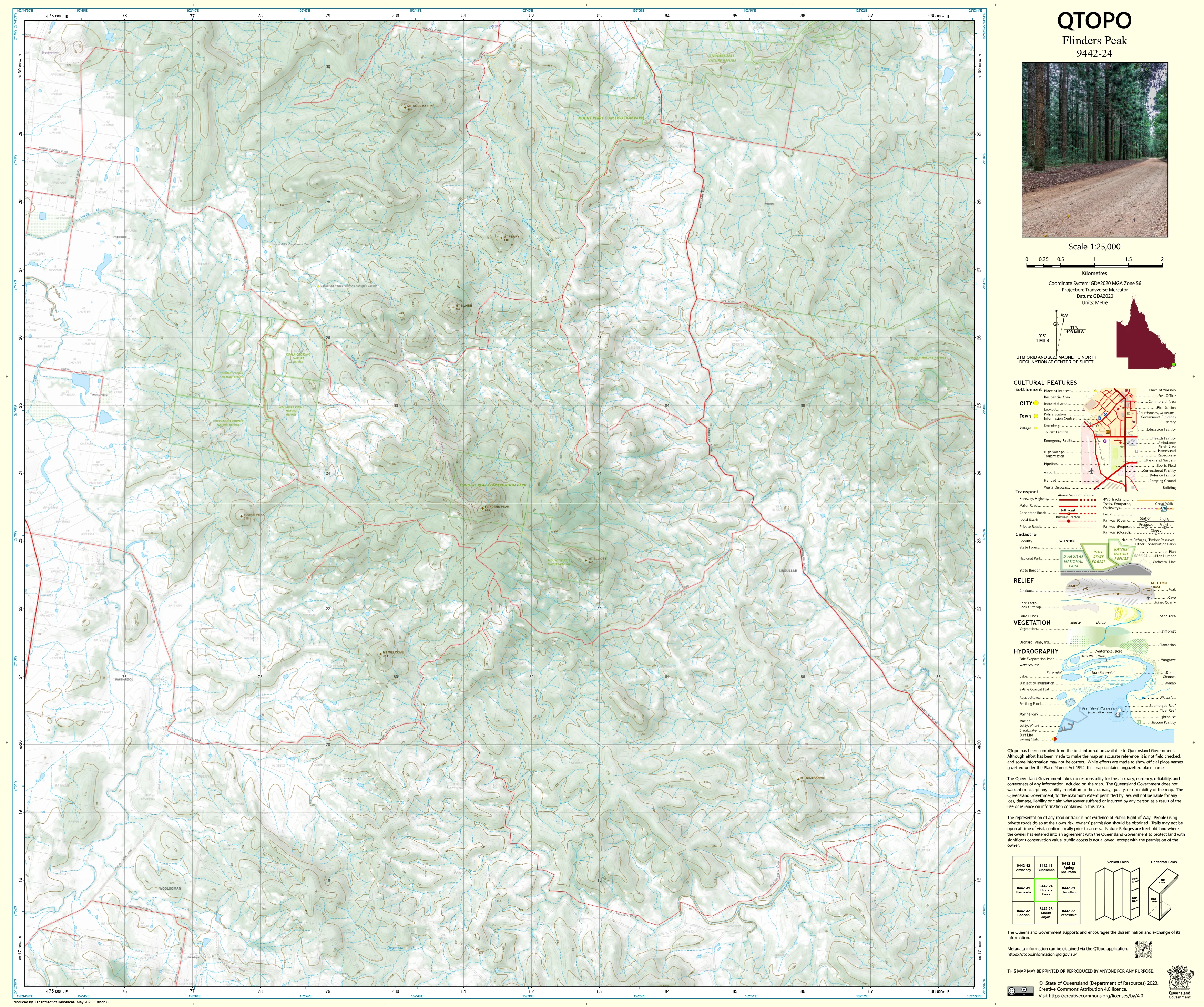
A high-resolution topographic map covering the iconic Flinders Peak region—one of South East Queensland’s most recognisable mountains and a dominant feature of the Flinders–Goolman Conservation Estate. Defined by steep volcanic ridges, dramatic escarpments, densely forested slopes, and rugged sandstone outcrops, this is an area where accurate mapping is essential for safety, environmental management, and advanced navigation.
The QTopo 9442-24 (Flinders Peak) sheet—produced by the Queensland Department of Resources—is part of the authoritative 1:25,000 state mapping series. It delivers detailed elevation modelling, hydrology information, vegetation mapping, and access networks across one of the Scenic Rim’s most important natural landscapes.
Whether you’re hiking the challenging Flinders Peak ascent, conducting ecological surveys, managing conservation land, or navigating remote ridgelines, QTopo 9442-24 provides the precision and clarity required for confident fieldwork.
🗺️ Map Content and Features
At 1:25,000 scale—meaning 1 cm = 250 m—this map includes:
-
Contour lines capturing the steep volcanic slopes, sharp ridgelines, cliffs, gullies, and high points around Flinders Peak
-
Hydrology features: creeks, drainage lines, ephemeral waterholes, and catchment systems
-
Access routes including walking tracks, fire trails, management roads, and rural property tracks
-
Infrastructure such as fencelines, communication towers, powerlines, and reserve boundary markers
-
Vegetation mapping showing open woodland, dense eucalypt forest, scrub, rocky heath, and riparian vegetation
-
Land tenure boundaries: national parks, conservation estates, freehold land, and state-managed reserves
-
Named natural features including Flinders Peak, Mt Blaine, Mt Goolman, rocky bluffs, saddles, and scenic lookouts
-
Points of interest relevant to ecologists, rangers, surveyors, emergency services, and experienced hikers
Every QTopo map is compiled from Queensland’s authoritative spatial datasets, ensuring trustworthy accuracy.
🧭 Who Uses This Map?
The Flinders Peak 9442-24 Topographic Map is widely used by:
-
Hikers & mountaineers – tackling steep summit routes and ridge traverses
-
Environmental scientists & ecologists – vegetation surveys, fauna monitoring, and fire management
-
Surveyors & planners – terrain analysis, boundary interpretation, and environmental planning
-
Rangers & conservation officers – managing protected areas and maintaining access networks
-
Emergency services & SES – search & rescue, bushfire operations, and remote incident coordination
-
Outdoor educators – teaching advanced navigation and landform interpretation
A vital and dependable mapping tool for both professional and advanced recreational use.
💧 Field-Ready Options for Steep, Rugged & Forested Terrain
Choose a finish designed to withstand the conditions typical of the Flinders–Goolman high country.
✅ Waterproof & Tearproof Tyvek®
-
Printed on DuPont™ Tyvek®
-
Fully waterproof, tear-resistant, and lightweight
-
Ideal for steep climbs, creek crossings, and wet-season fieldwork
✅ Laminated Edition
-
Encapsulated in 2 × 80-micron gloss laminate
-
Writeable surface compatible with whiteboard markers
-
Resists moisture, mud, dust, and heavy handling
📄 Standard Paper Edition
-
Crisp, high-resolution printing
-
Perfect for study, planning, and occasional field reference
📐 Map Details
Title: QTopo 9442-24 — Flinders Peak
Publisher: Queensland Department of Resources
Series: QTopo 1:25,000
Scale: 1:25,000 (1 cm = 250 m)
Dimensions: 710 mm (width) × 594 mm (height)
Coverage: Flinders Peak, Mt Blaine, Mt Goolman, surrounding volcanic foothills, creek systems, conservation estate, and rural access routes
Material Options: Paper, laminated, or waterproof Tyvek®
Printed in: Australia
Edition: Latest available (see listing)
📥 QTopo Map Index
Need adjoining Scenic Rim or Ipswich region maps?
➡️ Provide nearby sheet numbers—such as 9442-14, 9442-23, or 9342-33—and I’ll identify the appropriate adjoining sheets instantly.
🛒 Ordering & Options
-
Standard folded paper map – ideal for route planning, reference, and education
-
Tyvek® waterproof edition – perfect for rugged hiking and all-weather field operations
-
Laminated edition – reusable, durable, and excellent for conservation work or emergency planning
-
Flat (unfolded) maps available for wall or map-board display
🎯 Summary
The QTopo 9442-24 — Flinders Peak Topographic Map provides essential detail on terrain, hydrology, vegetation, and access across one of Queensland’s most iconic and challenging volcanic landscapes. With authoritative 1:25,000 mapping and tough field-ready printing options, it is indispensable for ecologists, hikers, surveyors, rangers, and emergency services.
Plan with purpose.
Navigate with confidence.
Explore with clarity.
Choose your preferred finish today and take Flinders Peak into the field with Queensland’s most trusted topographic mapping.
Product Information
Product Information
Shipping & Returns
Shipping & Returns
Description
QTopo 9442-24 — Flinders Peak
1:25,000 Topographic Map
A high-resolution topographic map covering the iconic Flinders Peak region—one of South East Queensland’s most recognisable mountains and a dominant feature of the Flinders–Goolman Conservation Estate. Defined by steep volcanic ridges, dramatic escarpments, densely forested slopes, and rugged sandstone outcrops, this is an area where accurate mapping is essential for safety, environmental management, and advanced navigation.
The QTopo 9442-24 (Flinders Peak) sheet—produced by the Queensland Department of Resources—is part of the authoritative 1:25,000 state mapping series. It delivers detailed elevation modelling, hydrology information, vegetation mapping, and access networks across one of the Scenic Rim’s most important natural landscapes.
Whether you’re hiking the challenging Flinders Peak ascent, conducting ecological surveys, managing conservation land, or navigating remote ridgelines, QTopo 9442-24 provides the precision and clarity required for confident fieldwork.
🗺️ Map Content and Features
At 1:25,000 scale—meaning 1 cm = 250 m—this map includes:
-
Contour lines capturing the steep volcanic slopes, sharp ridgelines, cliffs, gullies, and high points around Flinders Peak
-
Hydrology features: creeks, drainage lines, ephemeral waterholes, and catchment systems
-
Access routes including walking tracks, fire trails, management roads, and rural property tracks
-
Infrastructure such as fencelines, communication towers, powerlines, and reserve boundary markers
-
Vegetation mapping showing open woodland, dense eucalypt forest, scrub, rocky heath, and riparian vegetation
-
Land tenure boundaries: national parks, conservation estates, freehold land, and state-managed reserves
-
Named natural features including Flinders Peak, Mt Blaine, Mt Goolman, rocky bluffs, saddles, and scenic lookouts
-
Points of interest relevant to ecologists, rangers, surveyors, emergency services, and experienced hikers
Every QTopo map is compiled from Queensland’s authoritative spatial datasets, ensuring trustworthy accuracy.
🧭 Who Uses This Map?
The Flinders Peak 9442-24 Topographic Map is widely used by:
-
Hikers & mountaineers – tackling steep summit routes and ridge traverses
-
Environmental scientists & ecologists – vegetation surveys, fauna monitoring, and fire management
-
Surveyors & planners – terrain analysis, boundary interpretation, and environmental planning
-
Rangers & conservation officers – managing protected areas and maintaining access networks
-
Emergency services & SES – search & rescue, bushfire operations, and remote incident coordination
-
Outdoor educators – teaching advanced navigation and landform interpretation
A vital and dependable mapping tool for both professional and advanced recreational use.
💧 Field-Ready Options for Steep, Rugged & Forested Terrain
Choose a finish designed to withstand the conditions typical of the Flinders–Goolman high country.
✅ Waterproof & Tearproof Tyvek®
-
Printed on DuPont™ Tyvek®
-
Fully waterproof, tear-resistant, and lightweight
-
Ideal for steep climbs, creek crossings, and wet-season fieldwork
✅ Laminated Edition
-
Encapsulated in 2 × 80-micron gloss laminate
-
Writeable surface compatible with whiteboard markers
-
Resists moisture, mud, dust, and heavy handling
📄 Standard Paper Edition
-
Crisp, high-resolution printing
-
Perfect for study, planning, and occasional field reference
📐 Map Details
Title: QTopo 9442-24 — Flinders Peak
Publisher: Queensland Department of Resources
Series: QTopo 1:25,000
Scale: 1:25,000 (1 cm = 250 m)
Dimensions: 710 mm (width) × 594 mm (height)
Coverage: Flinders Peak, Mt Blaine, Mt Goolman, surrounding volcanic foothills, creek systems, conservation estate, and rural access routes
Material Options: Paper, laminated, or waterproof Tyvek®
Printed in: Australia
Edition: Latest available (see listing)
📥 QTopo Map Index
Need adjoining Scenic Rim or Ipswich region maps?
➡️ Provide nearby sheet numbers—such as 9442-14, 9442-23, or 9342-33—and I’ll identify the appropriate adjoining sheets instantly.
🛒 Ordering & Options
-
Standard folded paper map – ideal for route planning, reference, and education
-
Tyvek® waterproof edition – perfect for rugged hiking and all-weather field operations
-
Laminated edition – reusable, durable, and excellent for conservation work or emergency planning
-
Flat (unfolded) maps available for wall or map-board display
🎯 Summary
The QTopo 9442-24 — Flinders Peak Topographic Map provides essential detail on terrain, hydrology, vegetation, and access across one of Queensland’s most iconic and challenging volcanic landscapes. With authoritative 1:25,000 mapping and tough field-ready printing options, it is indispensable for ecologists, hikers, surveyors, rangers, and emergency services.
Plan with purpose.
Navigate with confidence.
Explore with clarity.
Choose your preferred finish today and take Flinders Peak into the field with Queensland’s most trusted topographic mapping.


