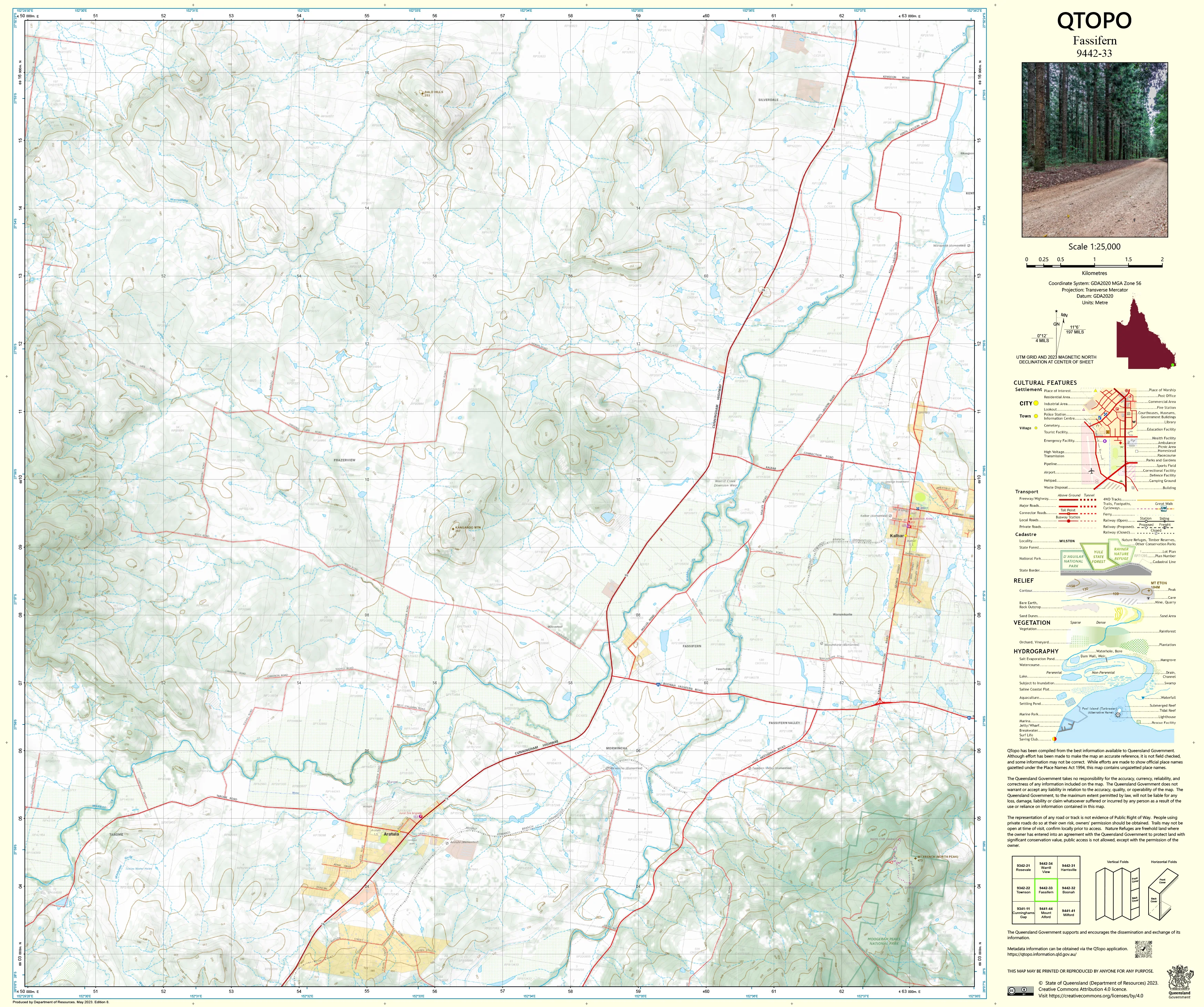
9442-33 Fassifern QTopo 1:25,000 Topographic Map
QTopo 9442-33 — Fassifern
1:25,000 Topographic Map
A detailed topographic map covering the Fassifern region—one of South East Queensland’s most productive agricultural valleys, framed by rolling hills, rural townships, creek systems, and the distant Scenic Rim ranges. With its combination of fertile farmland, transport corridors, irrigation infrastructure, and low-lying floodplains, this is an area where accurate mapping is essential for rural operations, planning, risk assessment, and environmental fieldwork.
The QTopo 9442-33 (Fassifern) sheet—produced by the Queensland Department of Resources—forms part of the authoritative 1:25,000 state mapping series. It provides precise elevation data, hydrology detail, vegetation mapping, and access information across one of the region’s most important and long-established agricultural landscapes.
Whether you’re managing property infrastructure, conducting environmental surveys, modelling water movement, or navigating rural backroads, QTopo 9442-33 offers the accuracy and clarity required for confident on-ground decision-making.
🗺️ Map Content and Features
At 1:25,000 scale—where 1 cm = 250 m—this high-detail sheet includes:
-
Contour lines showing undulating farmland, gentle ridges, drainage depressions, and surrounding foothills
-
Hydrology features: creeks, irrigation channels, drains, dams, waterholes, and seasonal flow paths
-
Road networks & rural access tracks linking homesteads, farms, townsites, and valley-floor routes
-
Infrastructure including powerlines, fencelines, pump sites, sheds, stockyards, silos, and community facilities
-
Vegetation mapping depicting cleared farmland, woodland remnants, grassland, riparian habitat, and reserve areas
-
Land tenure boundaries: freehold properties, reserves, state land parcels, and council-managed areas
-
Named features including hills, roads, localities, creek systems, and rural landmarks
-
Points of interest for surveyors, ecologists, rural landholders, planners, and emergency responders
All QTopo mapping is derived from Queensland’s authoritative spatial datasets, ensuring accuracy and consistency across the series.
🧭 Who Uses This Map?
The Fassifern 9442-33 Topographic Map is widely used by:
-
Farmers & graziers – paddock planning, water management, infrastructure layout
-
Environmental scientists & ecologists – habitat surveys, catchment analysis, vegetation studies
-
Surveyors & planners – boundary interpretation, terrain modelling, rural development work
-
Emergency services & SES – flood assessment, incident coordination, bushfire response
-
Local government & utilities – infrastructure planning and land-use assessment
-
4WD explorers & rural travellers – navigating valley-floor roads and semi-remote routes
-
Educators & students – learning landform interpretation and rural geography
A valuable resource for both professional and recreational users.
💧 Field-Ready Options for Valley, Farm & Creek Environments
Choose a print finish that performs well in Fassifern’s agricultural and outdoor conditions.
✅ Waterproof & Tearproof Tyvek®
-
Printed on DuPont™ Tyvek®
-
Fully waterproof, tear-resistant, and durable
-
Excellent for irrigation surveys, creek monitoring, and all-weather fieldwork
✅ Laminated Edition
-
Encapsulated in 2 × 80-micron gloss laminate
-
Writeable surface compatible with whiteboard markers
-
Resistant to moisture, dirt, dust, and rough handling
📄 Standard Paper Edition
-
Crisp, high-resolution printing
-
Ideal for office planning, study, and occasional field reference
📐 Map Details
Title: QTopo 9442-33 — Fassifern
Publisher: Queensland Department of Resources
Series: QTopo 1:25,000
Scale: 1:25,000 (1 cm = 250 m)
Dimensions: 710 mm (width) × 594 mm (height)
Coverage: Fassifern Valley including farmland, creek systems, township areas, rural access routes, and surrounding foothills
Material Options: Paper, laminated, or waterproof Tyvek®
Printed in: Australia
Edition: Latest available (see listing for publication year)
📥 QTopo Map Index
Need adjoining Fassifern or Scenic Rim sheets?
➡️ Provide nearby sheet numbers—such as 9442-23, 9442-34, or 9441-44—and I’ll identify the adjoining maps instantly.
🛒 Ordering & Options
-
Standard folded paper map – ideal for planning, rural operations, and general reference
-
Tyvek® waterproof edition – durable and perfect for all-weather agricultural and environmental fieldwork
-
Laminated edition – resilient, reusable, and excellent for office or operational mapping
-
Flat (unfolded) maps available for wall or planning-board display
🎯 Summary
The QTopo 9442-33 — Fassifern Topographic Map delivers essential detail on terrain, hydrology, land use, and access across one of SEQ’s most productive and historic rural valleys. With authoritative 1:25,000 mapping and rugged print options, it is indispensable for farmers, ecologists, surveyors, planners, and emergency services.
Plan with purpose.
Navigate with confidence.
Explore with clarity.
Choose your preferred finish today and bring the Fassifern QTopo map into the field with Queensland’s most trusted topographic mapping.
Original: $14.27
-65%$14.27
$4.99Product Information
Product Information
Shipping & Returns
Shipping & Returns
Description
QTopo 9442-33 — Fassifern
1:25,000 Topographic Map
A detailed topographic map covering the Fassifern region—one of South East Queensland’s most productive agricultural valleys, framed by rolling hills, rural townships, creek systems, and the distant Scenic Rim ranges. With its combination of fertile farmland, transport corridors, irrigation infrastructure, and low-lying floodplains, this is an area where accurate mapping is essential for rural operations, planning, risk assessment, and environmental fieldwork.
The QTopo 9442-33 (Fassifern) sheet—produced by the Queensland Department of Resources—forms part of the authoritative 1:25,000 state mapping series. It provides precise elevation data, hydrology detail, vegetation mapping, and access information across one of the region’s most important and long-established agricultural landscapes.
Whether you’re managing property infrastructure, conducting environmental surveys, modelling water movement, or navigating rural backroads, QTopo 9442-33 offers the accuracy and clarity required for confident on-ground decision-making.
🗺️ Map Content and Features
At 1:25,000 scale—where 1 cm = 250 m—this high-detail sheet includes:
-
Contour lines showing undulating farmland, gentle ridges, drainage depressions, and surrounding foothills
-
Hydrology features: creeks, irrigation channels, drains, dams, waterholes, and seasonal flow paths
-
Road networks & rural access tracks linking homesteads, farms, townsites, and valley-floor routes
-
Infrastructure including powerlines, fencelines, pump sites, sheds, stockyards, silos, and community facilities
-
Vegetation mapping depicting cleared farmland, woodland remnants, grassland, riparian habitat, and reserve areas
-
Land tenure boundaries: freehold properties, reserves, state land parcels, and council-managed areas
-
Named features including hills, roads, localities, creek systems, and rural landmarks
-
Points of interest for surveyors, ecologists, rural landholders, planners, and emergency responders
All QTopo mapping is derived from Queensland’s authoritative spatial datasets, ensuring accuracy and consistency across the series.
🧭 Who Uses This Map?
The Fassifern 9442-33 Topographic Map is widely used by:
-
Farmers & graziers – paddock planning, water management, infrastructure layout
-
Environmental scientists & ecologists – habitat surveys, catchment analysis, vegetation studies
-
Surveyors & planners – boundary interpretation, terrain modelling, rural development work
-
Emergency services & SES – flood assessment, incident coordination, bushfire response
-
Local government & utilities – infrastructure planning and land-use assessment
-
4WD explorers & rural travellers – navigating valley-floor roads and semi-remote routes
-
Educators & students – learning landform interpretation and rural geography
A valuable resource for both professional and recreational users.
💧 Field-Ready Options for Valley, Farm & Creek Environments
Choose a print finish that performs well in Fassifern’s agricultural and outdoor conditions.
✅ Waterproof & Tearproof Tyvek®
-
Printed on DuPont™ Tyvek®
-
Fully waterproof, tear-resistant, and durable
-
Excellent for irrigation surveys, creek monitoring, and all-weather fieldwork
✅ Laminated Edition
-
Encapsulated in 2 × 80-micron gloss laminate
-
Writeable surface compatible with whiteboard markers
-
Resistant to moisture, dirt, dust, and rough handling
📄 Standard Paper Edition
-
Crisp, high-resolution printing
-
Ideal for office planning, study, and occasional field reference
📐 Map Details
Title: QTopo 9442-33 — Fassifern
Publisher: Queensland Department of Resources
Series: QTopo 1:25,000
Scale: 1:25,000 (1 cm = 250 m)
Dimensions: 710 mm (width) × 594 mm (height)
Coverage: Fassifern Valley including farmland, creek systems, township areas, rural access routes, and surrounding foothills
Material Options: Paper, laminated, or waterproof Tyvek®
Printed in: Australia
Edition: Latest available (see listing for publication year)
📥 QTopo Map Index
Need adjoining Fassifern or Scenic Rim sheets?
➡️ Provide nearby sheet numbers—such as 9442-23, 9442-34, or 9441-44—and I’ll identify the adjoining maps instantly.
🛒 Ordering & Options
-
Standard folded paper map – ideal for planning, rural operations, and general reference
-
Tyvek® waterproof edition – durable and perfect for all-weather agricultural and environmental fieldwork
-
Laminated edition – resilient, reusable, and excellent for office or operational mapping
-
Flat (unfolded) maps available for wall or planning-board display
🎯 Summary
The QTopo 9442-33 — Fassifern Topographic Map delivers essential detail on terrain, hydrology, land use, and access across one of SEQ’s most productive and historic rural valleys. With authoritative 1:25,000 mapping and rugged print options, it is indispensable for farmers, ecologists, surveyors, planners, and emergency services.
Plan with purpose.
Navigate with confidence.
Explore with clarity.
Choose your preferred finish today and bring the Fassifern QTopo map into the field with Queensland’s most trusted topographic mapping.


