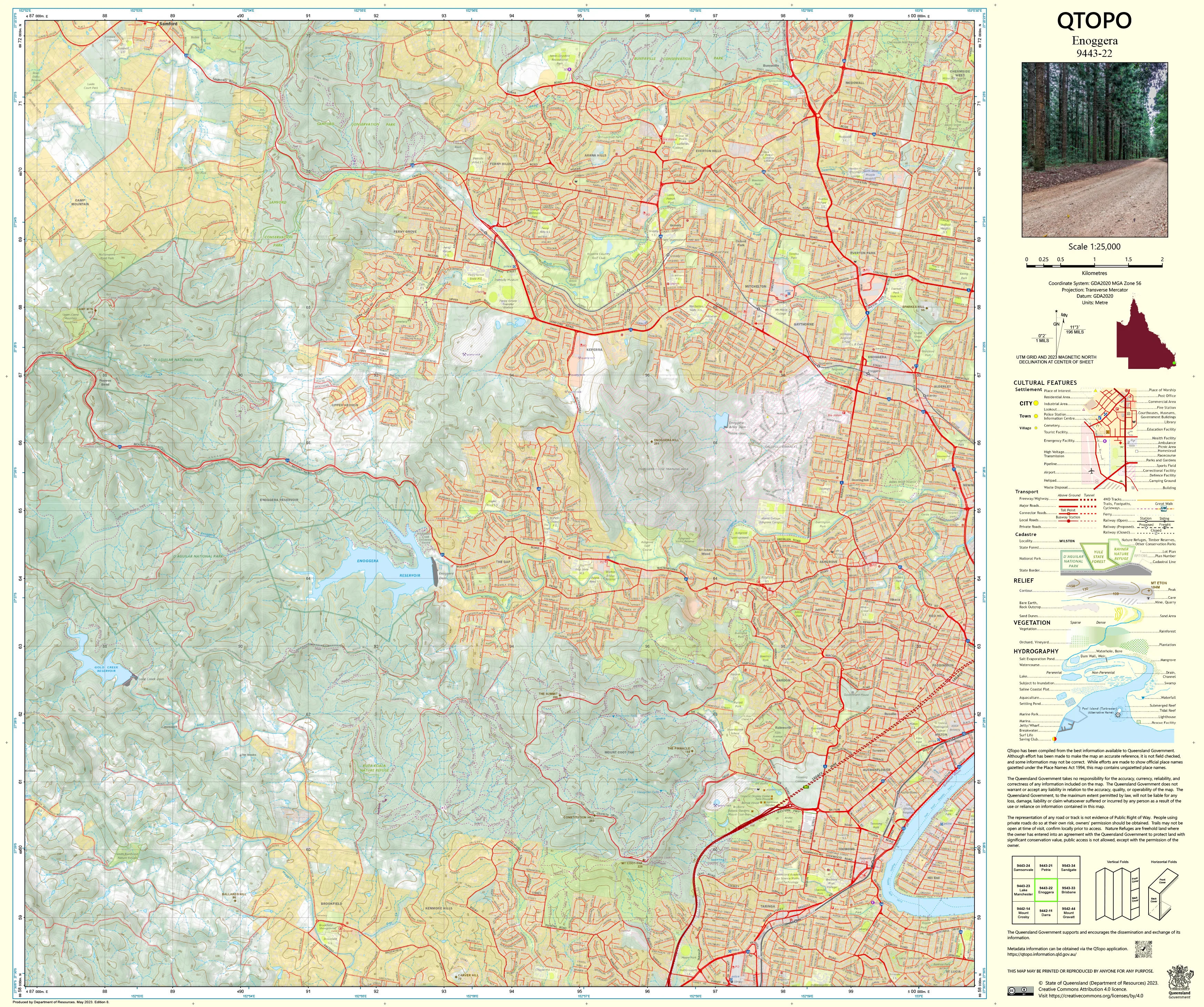
9443-22 Enoggera QTopo 1:25,000 Topographic Map
QTopo 9443-22 — Enoggera
1:25,000 Topographic Map
A detailed topographic map covering Enoggera—one of Brisbane’s most significant inner–northwest regions, blending suburban neighbourhoods, major transport corridors, defence land, forested hills, and key water catchments. With its combination of urban density, rugged bushland, hilly terrain, and important hydrological systems, this map is essential for planners, field crews, environmental specialists, and emergency response teams.
The QTopo 9443-22 (Enoggera) sheet—produced by the Queensland Department of Resources—forms part of the authoritative 1:25,000 statewide mapping series. It provides high-accuracy elevation modelling, hydrology structure, vegetation mapping, and infrastructure detail across an area critical to Brisbane’s water management, defence operations, and suburban development.
Whether you're conducting environmental surveys, managing urban bushland, interpreting drainage systems, or supporting emergency planning, QTopo 9443-22 delivers the clarity and reliability needed for effective decision-making.
🗺️ Map Content and Features
At 1:25,000 scale—with 1 cm representing 250 m—this detailed map includes:
-
Contour lines showing steep forested slopes, ridgelines, valley floors, suburban landforms, and flood-prone low areas
-
Hydrology features: Enoggera Reservoir, Enoggera Creek, drainage lines, wetlands, stormwater infrastructure
-
Road networks including major arterial roads, suburban streets, bike paths, fire trails, and defence access routes
-
Infrastructure such as the Enoggera Barracks (Gallipoli Barracks), powerlines, fencelines, pump sites, bridges, and utility facilities
-
Vegetation mapping encompassing eucalypt forest, scrub, urban greenspace, suburban trees, and riparian corridors
-
Land tenure boundaries reflecting defence land, council reserves, freehold property, and state-managed areas
-
Named natural and urban features including parks, hills, suburbs, creek systems, and reservoir catchment zones
-
Points of interest for ecologists, planners, emergency crews, surveyors, and bushland managers
Every QTopo sheet is compiled using Queensland’s authoritative spatial datasets, ensuring consistent accuracy statewide.
🧭 Who Uses This Map?
The Enoggera 9443-22 Topographic Map is widely used by:
-
Urban planners & developers – zoning, infrastructure assessment, flood modelling
-
Environmental scientists & ecologists – catchment analysis, habitat surveys, bushland management
-
Emergency services & SES – flood response, bushfire planning, terrain-based operations
-
Surveyors & GIS professionals – contour analysis, parcel interpretation, terrain modelling
-
Defence personnel & contractors – navigation and infrastructure planning within defence precincts
-
Recreational users – exploring bushland reserves, mountain bike areas, and walking tracks
-
Educators & students – studying Brisbane’s hilly terrain and urban–natural interface
A versatile reference for professionals and outdoor users alike.
💧 Field-Ready Options for Urban–Bushland Environments
Choose a print finish suited to Enoggera’s varied terrain and operational requirements.
✅ Waterproof & Tearproof Tyvek®
-
Printed on DuPont™ Tyvek®
-
Fully waterproof, tear-resistant, and durable
-
Ideal for fieldwork around water catchments, bushland, and defence land
✅ Laminated Edition
-
Encapsulated in 2 × 80-micron gloss laminate
-
Writeable surface works with whiteboard markers
-
Resistant to moisture, grit, oils, and frequent handling
📄 Standard Paper Edition
-
Crisp, high-resolution printing
-
Ideal for office, planning, and educational use
📐 Map Details
Title: QTopo 9443-22 — Enoggera
Publisher: Queensland Department of Resources
Series: QTopo 1:25,000
Scale: 1:25,000 (1 cm = 250 m)
Dimensions: 710 mm (width) × 594 mm (height)
Coverage: Enoggera Reservoir, Enoggera Barracks, surrounding suburbs, forested hills, creek systems, and suburban–natural interface areas
Material Options: Paper, laminated, or waterproof Tyvek®
Printed in: Australia
Edition: Latest available (see listing)
📥 QTopo Map Index
Need adjoining Brisbane sheets?
➡️ Provide nearby sheet numbers—such as 9443-12, 9443-23, or 9343-13—and I’ll identify the adjoining maps instantly.
🛒 Ordering & Options
-
Standard folded paper map – ideal for planning, emergency reference, and study
-
Tyvek® waterproof edition – perfect for rugged bushland and field operations
-
Laminated edition – strong, reusable, and suited to workshops or operational boards
-
Flat (unfolded) maps available for wall or map-board display
🎯 Summary
The QTopo 9443-22 — Enoggera Topographic Map provides vital detail on terrain, hydrology, vegetation, access routes, and infrastructure across one of Brisbane’s most strategically significant inner–northwest districts. With authoritative 1:25,000 mapping and durable field-ready options, it is indispensable for planners, ecologists, emergency services, defence personnel, and outdoor users.
Plan with purpose.
Navigate with confidence.
Explore with clarity.
Choose your preferred finish today and equip yourself with Queensland’s most trusted topographic mapping.
Original: $14.27
-65%$14.27
$4.99Product Information
Product Information
Shipping & Returns
Shipping & Returns
Description
QTopo 9443-22 — Enoggera
1:25,000 Topographic Map
A detailed topographic map covering Enoggera—one of Brisbane’s most significant inner–northwest regions, blending suburban neighbourhoods, major transport corridors, defence land, forested hills, and key water catchments. With its combination of urban density, rugged bushland, hilly terrain, and important hydrological systems, this map is essential for planners, field crews, environmental specialists, and emergency response teams.
The QTopo 9443-22 (Enoggera) sheet—produced by the Queensland Department of Resources—forms part of the authoritative 1:25,000 statewide mapping series. It provides high-accuracy elevation modelling, hydrology structure, vegetation mapping, and infrastructure detail across an area critical to Brisbane’s water management, defence operations, and suburban development.
Whether you're conducting environmental surveys, managing urban bushland, interpreting drainage systems, or supporting emergency planning, QTopo 9443-22 delivers the clarity and reliability needed for effective decision-making.
🗺️ Map Content and Features
At 1:25,000 scale—with 1 cm representing 250 m—this detailed map includes:
-
Contour lines showing steep forested slopes, ridgelines, valley floors, suburban landforms, and flood-prone low areas
-
Hydrology features: Enoggera Reservoir, Enoggera Creek, drainage lines, wetlands, stormwater infrastructure
-
Road networks including major arterial roads, suburban streets, bike paths, fire trails, and defence access routes
-
Infrastructure such as the Enoggera Barracks (Gallipoli Barracks), powerlines, fencelines, pump sites, bridges, and utility facilities
-
Vegetation mapping encompassing eucalypt forest, scrub, urban greenspace, suburban trees, and riparian corridors
-
Land tenure boundaries reflecting defence land, council reserves, freehold property, and state-managed areas
-
Named natural and urban features including parks, hills, suburbs, creek systems, and reservoir catchment zones
-
Points of interest for ecologists, planners, emergency crews, surveyors, and bushland managers
Every QTopo sheet is compiled using Queensland’s authoritative spatial datasets, ensuring consistent accuracy statewide.
🧭 Who Uses This Map?
The Enoggera 9443-22 Topographic Map is widely used by:
-
Urban planners & developers – zoning, infrastructure assessment, flood modelling
-
Environmental scientists & ecologists – catchment analysis, habitat surveys, bushland management
-
Emergency services & SES – flood response, bushfire planning, terrain-based operations
-
Surveyors & GIS professionals – contour analysis, parcel interpretation, terrain modelling
-
Defence personnel & contractors – navigation and infrastructure planning within defence precincts
-
Recreational users – exploring bushland reserves, mountain bike areas, and walking tracks
-
Educators & students – studying Brisbane’s hilly terrain and urban–natural interface
A versatile reference for professionals and outdoor users alike.
💧 Field-Ready Options for Urban–Bushland Environments
Choose a print finish suited to Enoggera’s varied terrain and operational requirements.
✅ Waterproof & Tearproof Tyvek®
-
Printed on DuPont™ Tyvek®
-
Fully waterproof, tear-resistant, and durable
-
Ideal for fieldwork around water catchments, bushland, and defence land
✅ Laminated Edition
-
Encapsulated in 2 × 80-micron gloss laminate
-
Writeable surface works with whiteboard markers
-
Resistant to moisture, grit, oils, and frequent handling
📄 Standard Paper Edition
-
Crisp, high-resolution printing
-
Ideal for office, planning, and educational use
📐 Map Details
Title: QTopo 9443-22 — Enoggera
Publisher: Queensland Department of Resources
Series: QTopo 1:25,000
Scale: 1:25,000 (1 cm = 250 m)
Dimensions: 710 mm (width) × 594 mm (height)
Coverage: Enoggera Reservoir, Enoggera Barracks, surrounding suburbs, forested hills, creek systems, and suburban–natural interface areas
Material Options: Paper, laminated, or waterproof Tyvek®
Printed in: Australia
Edition: Latest available (see listing)
📥 QTopo Map Index
Need adjoining Brisbane sheets?
➡️ Provide nearby sheet numbers—such as 9443-12, 9443-23, or 9343-13—and I’ll identify the adjoining maps instantly.
🛒 Ordering & Options
-
Standard folded paper map – ideal for planning, emergency reference, and study
-
Tyvek® waterproof edition – perfect for rugged bushland and field operations
-
Laminated edition – strong, reusable, and suited to workshops or operational boards
-
Flat (unfolded) maps available for wall or map-board display
🎯 Summary
The QTopo 9443-22 — Enoggera Topographic Map provides vital detail on terrain, hydrology, vegetation, access routes, and infrastructure across one of Brisbane’s most strategically significant inner–northwest districts. With authoritative 1:25,000 mapping and durable field-ready options, it is indispensable for planners, ecologists, emergency services, defence personnel, and outdoor users.
Plan with purpose.
Navigate with confidence.
Explore with clarity.
Choose your preferred finish today and equip yourself with Queensland’s most trusted topographic mapping.


