9443-24 Samsonvale QTopo 1:25,000 Topographic Map
QTopo 9443-24 — Samsonvale
1:25,000 Topographic Map
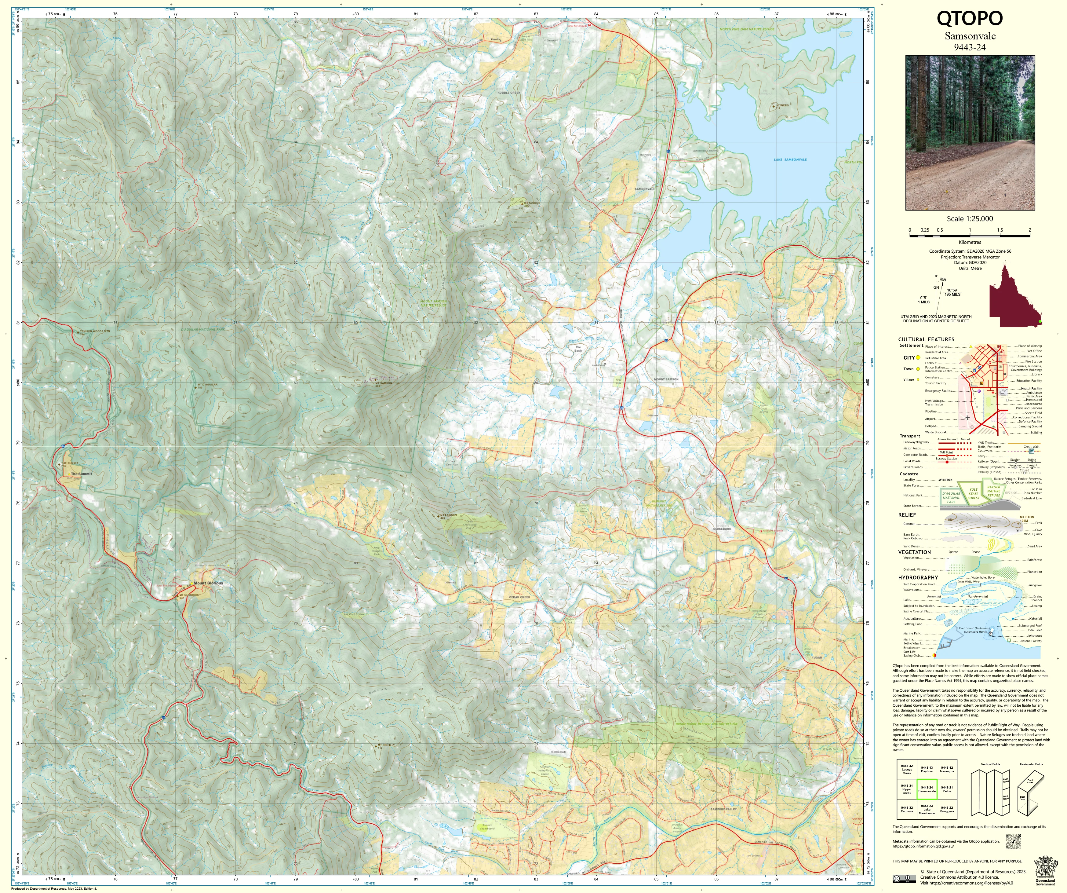
A detailed topographic map covering the Samsonvale region—home to Lake Samsonvale (North Pine Dam), rolling rural landscapes, forested hills, recreation areas, and expanding semi-rural residential communities. As one of South East Queensland’s key water storage catchments, this area combines complex hydrology, steep terrain, and restricted-access land, making accurate mapping essential for planners, environmental specialists, emergency responders, and outdoor users.
The QTopo 9443-24 (Samsonvale) sheet—produced by the Queensland Department of Resources—is part of Queensland’s authoritative 1:25,000 mapping series. It provides high-precision elevation data, hydrology structure, vegetation mapping, and infrastructure detail across one of the Moreton Bay region’s most important environmental and recreational landscapes.
Whether you're navigating recreational trails, conducting water catchment work, planning rural development, or assessing ecological conditions, QTopo 9443-24 delivers the detail and reliability required for informed decision-making.
🗺️ Map Content and Features
At 1:25,000 scale—with 1 cm representing 250 m—this map includes:
-
Contour lines showing hills, slopes, floodplains, ridgelines, and forested high ground
-
Hydrology features: Lake Samsonvale, North Pine River, tributaries, drainage networks, waterholes, and reservoir infrastructure
-
Roads, rural access tracks & recreational routes connecting townships, farms, recreation areas, and bushland
-
Infrastructure including water supply assets, picnic areas, powerlines, fencelines, boat ramps, and management facilities
-
Vegetation mapping covering forest reserves, woodlands, grasslands, cleared farmland, and riparian environments
-
Land tenure boundaries: SEQ water catchment land, conservation reserves, freehold rural properties, and council-managed open space
-
Named features such as prominent hills, creek systems, recreation areas, locality boundaries, and shoreline landmarks
-
Points of interest for rangers, surveyors, ecologists, emergency services, and recreational visitors
Every QTopo sheet uses Queensland’s authoritative spatial datasets, ensuring accuracy and mapping consistency across the region.
🧭 Who Uses This Map?
The Samsonvale 9443-24 Topographic Map is widely used by:
-
Environmental scientists & ecologists – habitat studies, catchment analysis, vegetation monitoring
-
Water authorities & rangers – planning and managing reservoir lands and restricted zones
-
Surveyors & planners – land-use assessment, terrain modelling, and rural development planning
-
Emergency services & SES – bushfire planning, flood response, incident navigation
-
Bushwalkers, anglers & outdoor users – exploring trails, shoreline areas, and recreation facilities
-
Local government – infrastructure planning and environmental assessment
-
Educators & students – studying catchment landscapes and topographic interpretation
A crucial reference for both professional and recreational users.
💧 Field-Ready Options for Catchment, Rural & Forested Terrain
Choose a print finish suited to the varied conditions around Lake Samsonvale and its surrounding countryside.
✅ Waterproof & Tearproof Tyvek®
-
Printed on DuPont™ Tyvek®
-
Fully waterproof, tear-resistant, and lightweight
-
Ideal for shoreline surveys, creek monitoring, and all-weather fieldwork
✅ Laminated Edition
-
Encapsulated in 2 × 80-micron gloss laminate
-
Writeable surface supports whiteboard markers
-
Tough, reusable, and resistant to water, mud, and repeated handling
📄 Standard Paper Edition
-
Crisp, high-quality printing
-
Perfect for planning, reference, and light fieldwork
📐 Map Details
Title: QTopo 9443-24 — Samsonvale
Publisher: Queensland Department of Resources
Series: QTopo 1:25,000
Scale: 1:25,000 (1 cm = 250 m)
Dimensions: 710 mm (width) × 594 mm (height)
Coverage: Lake Samsonvale, North Pine River, surrounding rural communities, recreation areas, forest reserves, and hill country
Material Options: Paper, laminated, or waterproof Tyvek®
Printed in: Australia
Edition: Latest available (see listing)
📥 QTopo Map Index
Need adjacent Moreton Bay or D’Aguilar Range sheets?
➡️ Provide nearby sheet numbers—such as 9443-23, 9443-25, or 9343-24—and I’ll identify the adjoining maps instantly.
🛒 Ordering & Options
-
Standard folded paper map – ideal for planning, study, and general reference
-
Tyvek® waterproof edition – excellent for rugged outdoor and wet-area fieldwork
-
Laminated edition – durable, reusable, and perfect for operational or educational settings
-
Flat (unfolded) maps available for wall or map-board display
🎯 Summary
The QTopo 9443-24 — Samsonvale Topographic Map provides essential detail on terrain, hydrology, vegetation, and access across one of the Moreton Bay region’s most important catchment and recreational landscapes. With authoritative 1:25,000 mapping and durable print options, it is indispensable for ecologists, planners, surveyors, rangers, emergency responders, and outdoor explorers.
Plan with purpose.
Navigate with confidence.
Explore with clarity.
Choose your preferred finish today and take the Samsonvale QTopo map into the field with Queensland’s most trusted topographic mapping.
Original: $14.27
-65%$14.27
$4.99Product Information
Product Information
Shipping & Returns
Shipping & Returns
Description
QTopo 9443-24 — Samsonvale
1:25,000 Topographic Map
A detailed topographic map covering the Samsonvale region—home to Lake Samsonvale (North Pine Dam), rolling rural landscapes, forested hills, recreation areas, and expanding semi-rural residential communities. As one of South East Queensland’s key water storage catchments, this area combines complex hydrology, steep terrain, and restricted-access land, making accurate mapping essential for planners, environmental specialists, emergency responders, and outdoor users.
The QTopo 9443-24 (Samsonvale) sheet—produced by the Queensland Department of Resources—is part of Queensland’s authoritative 1:25,000 mapping series. It provides high-precision elevation data, hydrology structure, vegetation mapping, and infrastructure detail across one of the Moreton Bay region’s most important environmental and recreational landscapes.
Whether you're navigating recreational trails, conducting water catchment work, planning rural development, or assessing ecological conditions, QTopo 9443-24 delivers the detail and reliability required for informed decision-making.
🗺️ Map Content and Features
At 1:25,000 scale—with 1 cm representing 250 m—this map includes:
-
Contour lines showing hills, slopes, floodplains, ridgelines, and forested high ground
-
Hydrology features: Lake Samsonvale, North Pine River, tributaries, drainage networks, waterholes, and reservoir infrastructure
-
Roads, rural access tracks & recreational routes connecting townships, farms, recreation areas, and bushland
-
Infrastructure including water supply assets, picnic areas, powerlines, fencelines, boat ramps, and management facilities
-
Vegetation mapping covering forest reserves, woodlands, grasslands, cleared farmland, and riparian environments
-
Land tenure boundaries: SEQ water catchment land, conservation reserves, freehold rural properties, and council-managed open space
-
Named features such as prominent hills, creek systems, recreation areas, locality boundaries, and shoreline landmarks
-
Points of interest for rangers, surveyors, ecologists, emergency services, and recreational visitors
Every QTopo sheet uses Queensland’s authoritative spatial datasets, ensuring accuracy and mapping consistency across the region.
🧭 Who Uses This Map?
The Samsonvale 9443-24 Topographic Map is widely used by:
-
Environmental scientists & ecologists – habitat studies, catchment analysis, vegetation monitoring
-
Water authorities & rangers – planning and managing reservoir lands and restricted zones
-
Surveyors & planners – land-use assessment, terrain modelling, and rural development planning
-
Emergency services & SES – bushfire planning, flood response, incident navigation
-
Bushwalkers, anglers & outdoor users – exploring trails, shoreline areas, and recreation facilities
-
Local government – infrastructure planning and environmental assessment
-
Educators & students – studying catchment landscapes and topographic interpretation
A crucial reference for both professional and recreational users.
💧 Field-Ready Options for Catchment, Rural & Forested Terrain
Choose a print finish suited to the varied conditions around Lake Samsonvale and its surrounding countryside.
✅ Waterproof & Tearproof Tyvek®
-
Printed on DuPont™ Tyvek®
-
Fully waterproof, tear-resistant, and lightweight
-
Ideal for shoreline surveys, creek monitoring, and all-weather fieldwork
✅ Laminated Edition
-
Encapsulated in 2 × 80-micron gloss laminate
-
Writeable surface supports whiteboard markers
-
Tough, reusable, and resistant to water, mud, and repeated handling
📄 Standard Paper Edition
-
Crisp, high-quality printing
-
Perfect for planning, reference, and light fieldwork
📐 Map Details
Title: QTopo 9443-24 — Samsonvale
Publisher: Queensland Department of Resources
Series: QTopo 1:25,000
Scale: 1:25,000 (1 cm = 250 m)
Dimensions: 710 mm (width) × 594 mm (height)
Coverage: Lake Samsonvale, North Pine River, surrounding rural communities, recreation areas, forest reserves, and hill country
Material Options: Paper, laminated, or waterproof Tyvek®
Printed in: Australia
Edition: Latest available (see listing)
📥 QTopo Map Index
Need adjacent Moreton Bay or D’Aguilar Range sheets?
➡️ Provide nearby sheet numbers—such as 9443-23, 9443-25, or 9343-24—and I’ll identify the adjoining maps instantly.
🛒 Ordering & Options
-
Standard folded paper map – ideal for planning, study, and general reference
-
Tyvek® waterproof edition – excellent for rugged outdoor and wet-area fieldwork
-
Laminated edition – durable, reusable, and perfect for operational or educational settings
-
Flat (unfolded) maps available for wall or map-board display
🎯 Summary
The QTopo 9443-24 — Samsonvale Topographic Map provides essential detail on terrain, hydrology, vegetation, and access across one of the Moreton Bay region’s most important catchment and recreational landscapes. With authoritative 1:25,000 mapping and durable print options, it is indispensable for ecologists, planners, surveyors, rangers, emergency responders, and outdoor explorers.
Plan with purpose.
Navigate with confidence.
Explore with clarity.
Choose your preferred finish today and take the Samsonvale QTopo map into the field with Queensland’s most trusted topographic mapping.


