9443-244 Mount D'Aguilar QTopo 1:10,000 Topographic Map
Mount D’Aguilar — QTopo 9443-244
1:10,000 Topographic Map
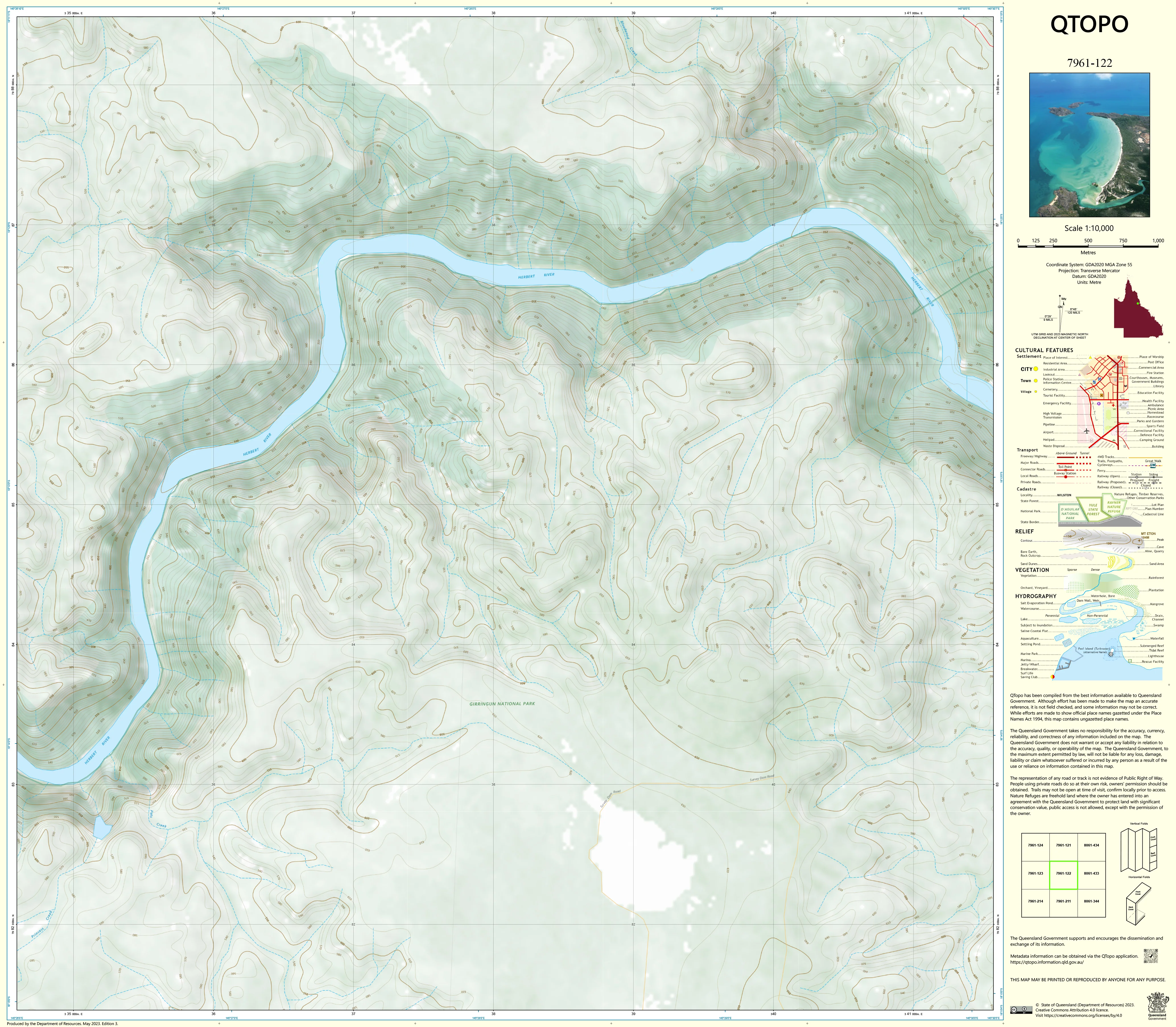
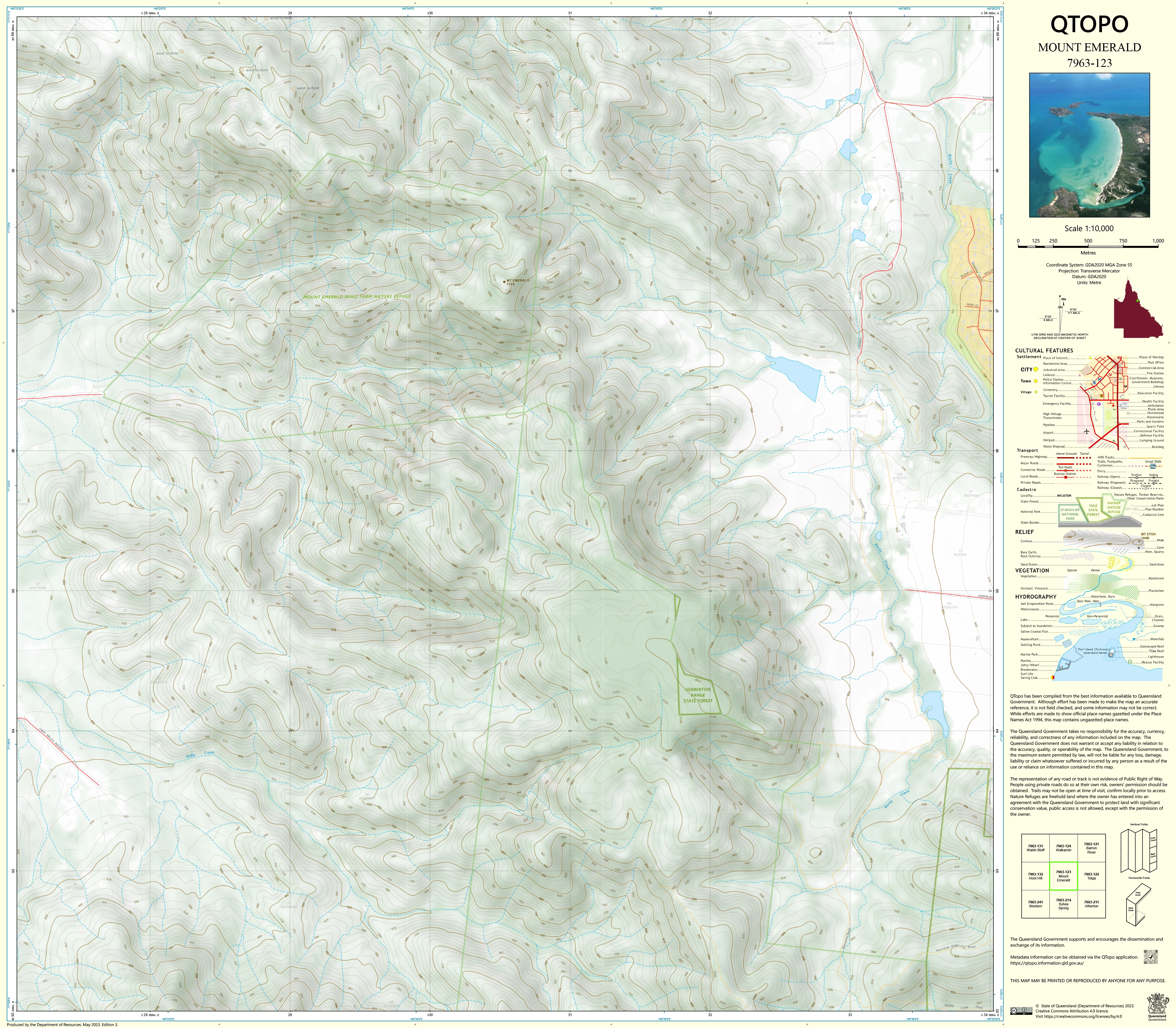
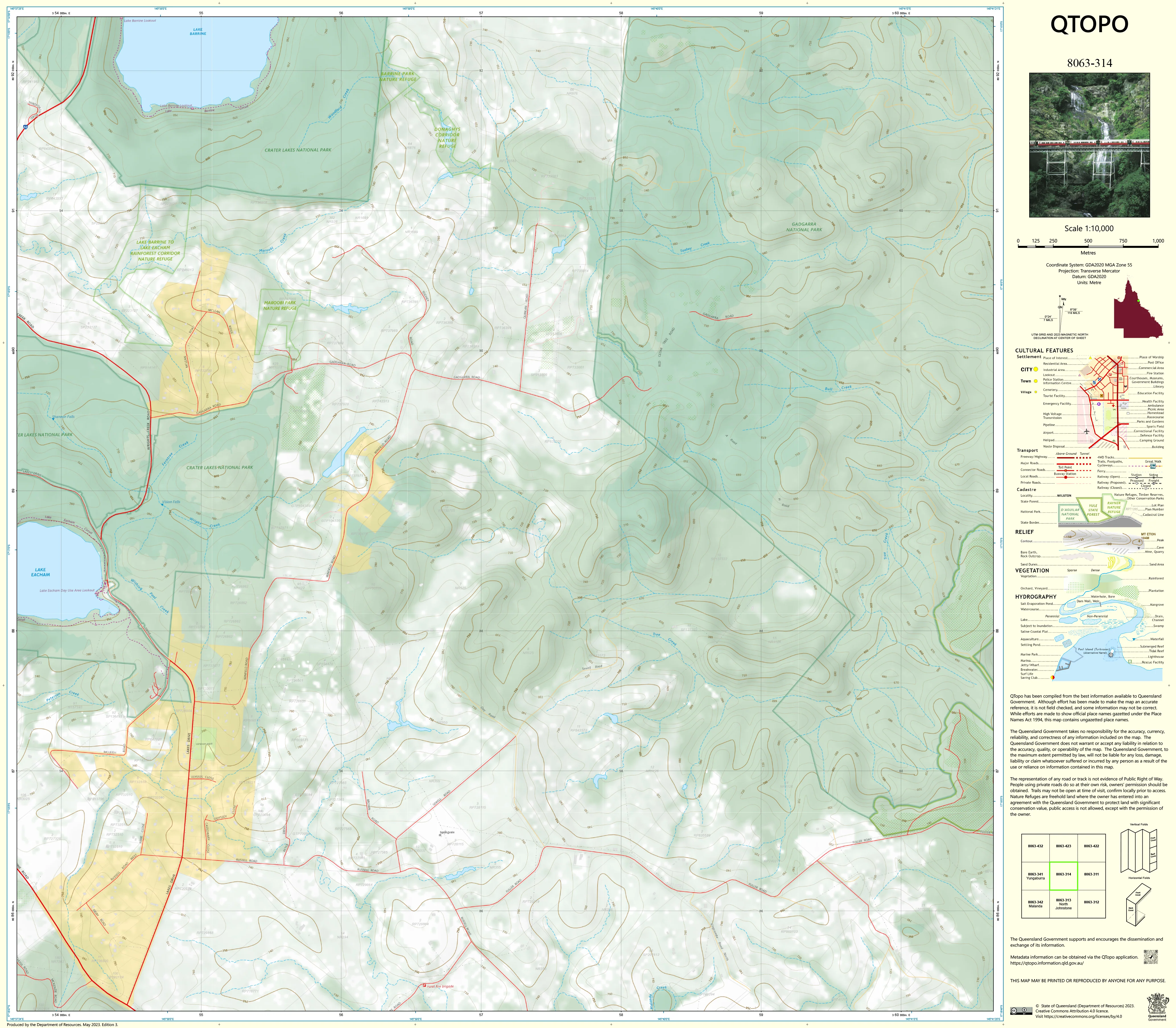
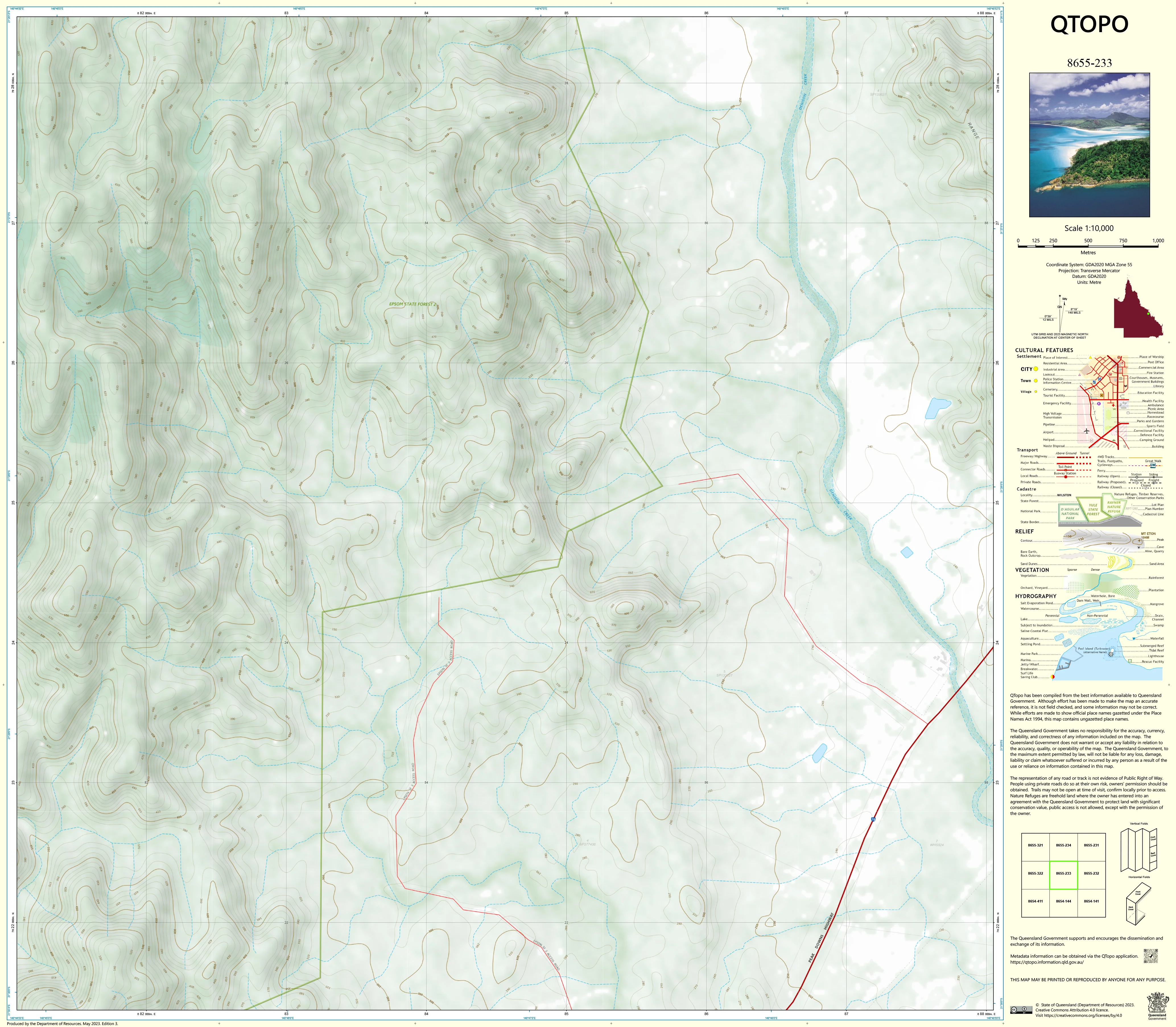
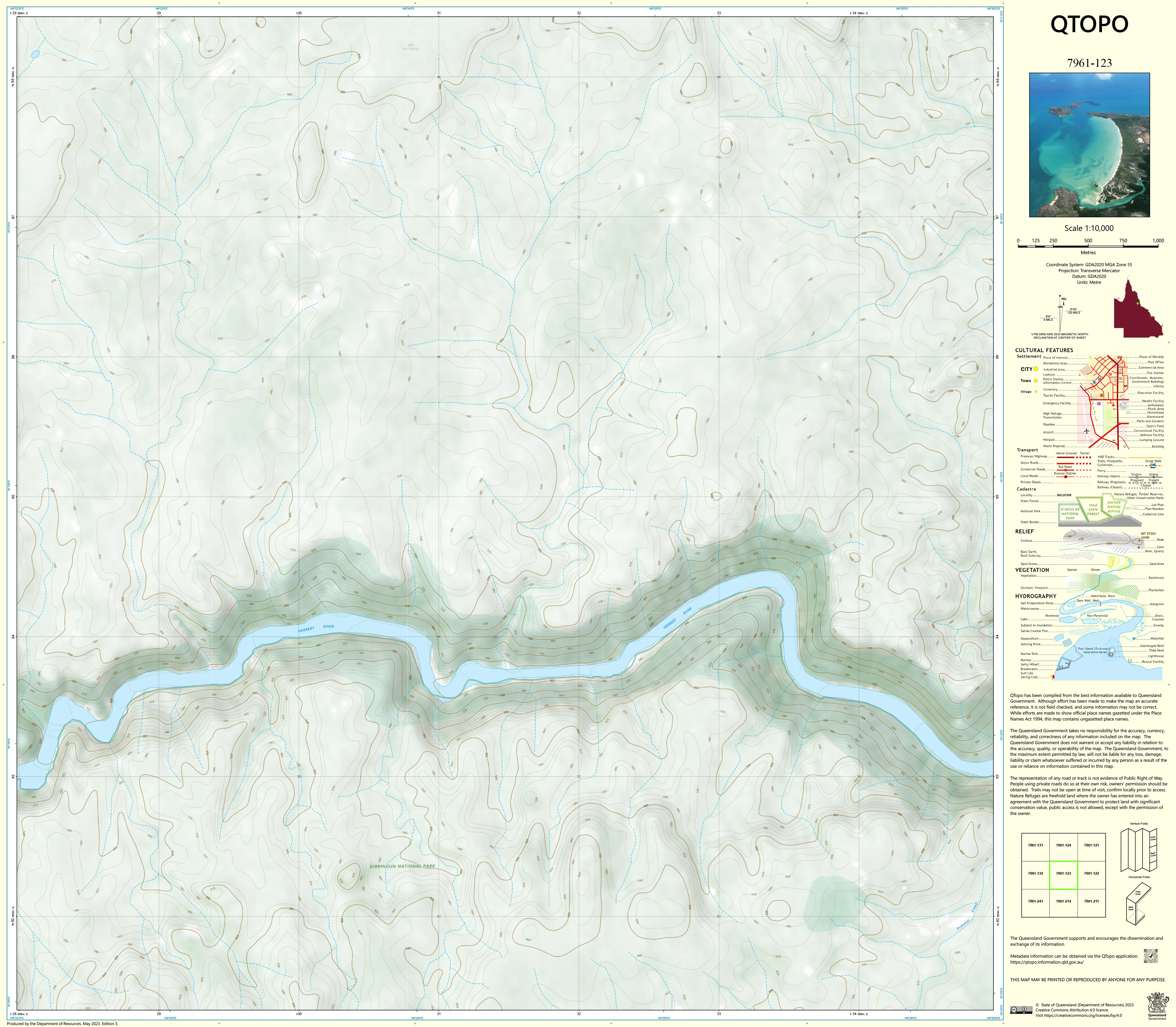
The QTopo 9443-244 — Mount D’Aguilar map provides high-precision topographic coverage of the central D’Aguilar Range, an area defined by steep terrain, dense forest, rugged ridgelines, remote trails, and protected conservation land. Produced at the 1:10,000 scale, this map delivers the accuracy required for surveying, engineering, ecological assessment, emergency operations, and land management across one of South East Queensland’s most significant natural landscapes.
Published by the Queensland Department of Resources, this authoritative sheet combines detailed contouring, hydrology networks, vegetation mapping, cadastral boundaries, and essential infrastructure information—ensuring clarity and reliability in both planning and field navigation.
🗺️ Map Content and Features
At 1:10,000 scale — 1 cm = 100 m — the map includes:
-
Fine contour lines capturing Mount D’Aguilar’s steep slopes, ravines, ridge systems, and elevation changes
-
Hydrology mapping: creeks, tributaries, drainage lines, tanks, dams, and riparian corridors
-
Infrastructure details:
-
Fire trails, walking tracks, management access roads
-
Lookouts, shelters, communication or monitoring sites
-
Surveyed cadastral boundaries, easements, fencelines, and property limits
-
Water infrastructure including pumps, troughs, tanks, and retention structures
-
-
Vegetation patterns: dense forest, woodland, scrub zones, open clearings, and ecological buffer areas
-
Land tenure: national park sections, conservation reserves, and adjacent freehold lots
-
Named features: Mount D’Aguilar ridges, creek systems, and local geographic identifiers
-
High-resolution symbology, suitable for professional analysis and on-ground operations
All mapping elements are sourced from Queensland’s authoritative geospatial datasets.
🧭 Who Uses This Map?
The Mount D’Aguilar 9443-244 (1:10,000) Topographic Map is ideal for:
-
Surveyors & engineers — terrain modelling, access planning, and infrastructure design
-
Environmental consultants & ecologists — habitat surveys, vegetation mapping, environmental monitoring
-
Rangers & land managers — track maintenance, fire planning, conservation strategy
-
Emergency services & SES — search-and-rescue navigation, hazard mapping, incident planning
-
Researchers & educators — geomorphology, hydrology, ecology, and field training
-
Field contractors & technicians — accurate navigation and operational planning
💧 Field-Ready Print Options
✅ Waterproof & Tearproof Tyvek®
-
Printed on DuPont™ Tyvek®
-
Fully waterproof, tear-resistant, and built for rugged field environments
✅ Laminated Edition
-
Encapsulated in 2 × 80-micron gloss laminate
-
Writeable surface compatible with whiteboard markers
-
Reusable, durable, and perfect for field briefings or planning boards
📄 Standard Paper Edition
-
Crisp, detailed print
-
Ideal for office reference, analysis, and reporting
📐 Map Details
Title: Mount D’Aguilar — QTopo 9443-244
Publisher: Queensland Department of Resources
Series: QTopo 1:10,000
Scale: 1:10,000 (1 cm = 100 m)
Dimensions: 840 mm (width) × 734 mm (height)
Coverage: Mount D’Aguilar summit area, ridgelines, creeks, vegetation, access trails, and cadastral boundaries
Material Options: Paper, laminated, or waterproof Tyvek®
Printed in: Australia
Edition: Latest available
🛒 Ordering & Options
-
Folded paper edition — compact and portable
-
Tyvek® waterproof edition — rugged and suitable for harsh conditions
-
Laminated edition — reusable and ideal for planning or training environments
🎯 Summary
The Mount D’Aguilar — QTopo 9443-244 — 1:10,000 Topographic Map offers outstanding fine-scale accuracy across one of South East Queensland’s most rugged and ecologically important landscapes. With detailed contours, hydrology, vegetation, and cadastral mapping, it is indispensable for surveyors, ecologists, emergency responders, and land managers.
Plan with precision.
Navigate with confidence.
Work with clarity.
Original: $14.27
-65%$14.27
$4.99Product Information
Product Information
Shipping & Returns
Shipping & Returns
Description
Mount D’Aguilar — QTopo 9443-244
1:10,000 Topographic Map
The QTopo 9443-244 — Mount D’Aguilar map provides high-precision topographic coverage of the central D’Aguilar Range, an area defined by steep terrain, dense forest, rugged ridgelines, remote trails, and protected conservation land. Produced at the 1:10,000 scale, this map delivers the accuracy required for surveying, engineering, ecological assessment, emergency operations, and land management across one of South East Queensland’s most significant natural landscapes.
Published by the Queensland Department of Resources, this authoritative sheet combines detailed contouring, hydrology networks, vegetation mapping, cadastral boundaries, and essential infrastructure information—ensuring clarity and reliability in both planning and field navigation.
🗺️ Map Content and Features
At 1:10,000 scale — 1 cm = 100 m — the map includes:
-
Fine contour lines capturing Mount D’Aguilar’s steep slopes, ravines, ridge systems, and elevation changes
-
Hydrology mapping: creeks, tributaries, drainage lines, tanks, dams, and riparian corridors
-
Infrastructure details:
-
Fire trails, walking tracks, management access roads
-
Lookouts, shelters, communication or monitoring sites
-
Surveyed cadastral boundaries, easements, fencelines, and property limits
-
Water infrastructure including pumps, troughs, tanks, and retention structures
-
-
Vegetation patterns: dense forest, woodland, scrub zones, open clearings, and ecological buffer areas
-
Land tenure: national park sections, conservation reserves, and adjacent freehold lots
-
Named features: Mount D’Aguilar ridges, creek systems, and local geographic identifiers
-
High-resolution symbology, suitable for professional analysis and on-ground operations
All mapping elements are sourced from Queensland’s authoritative geospatial datasets.
🧭 Who Uses This Map?
The Mount D’Aguilar 9443-244 (1:10,000) Topographic Map is ideal for:
-
Surveyors & engineers — terrain modelling, access planning, and infrastructure design
-
Environmental consultants & ecologists — habitat surveys, vegetation mapping, environmental monitoring
-
Rangers & land managers — track maintenance, fire planning, conservation strategy
-
Emergency services & SES — search-and-rescue navigation, hazard mapping, incident planning
-
Researchers & educators — geomorphology, hydrology, ecology, and field training
-
Field contractors & technicians — accurate navigation and operational planning
💧 Field-Ready Print Options
✅ Waterproof & Tearproof Tyvek®
-
Printed on DuPont™ Tyvek®
-
Fully waterproof, tear-resistant, and built for rugged field environments
✅ Laminated Edition
-
Encapsulated in 2 × 80-micron gloss laminate
-
Writeable surface compatible with whiteboard markers
-
Reusable, durable, and perfect for field briefings or planning boards
📄 Standard Paper Edition
-
Crisp, detailed print
-
Ideal for office reference, analysis, and reporting
📐 Map Details
Title: Mount D’Aguilar — QTopo 9443-244
Publisher: Queensland Department of Resources
Series: QTopo 1:10,000
Scale: 1:10,000 (1 cm = 100 m)
Dimensions: 840 mm (width) × 734 mm (height)
Coverage: Mount D’Aguilar summit area, ridgelines, creeks, vegetation, access trails, and cadastral boundaries
Material Options: Paper, laminated, or waterproof Tyvek®
Printed in: Australia
Edition: Latest available
🛒 Ordering & Options
-
Folded paper edition — compact and portable
-
Tyvek® waterproof edition — rugged and suitable for harsh conditions
-
Laminated edition — reusable and ideal for planning or training environments
🎯 Summary
The Mount D’Aguilar — QTopo 9443-244 — 1:10,000 Topographic Map offers outstanding fine-scale accuracy across one of South East Queensland’s most rugged and ecologically important landscapes. With detailed contours, hydrology, vegetation, and cadastral mapping, it is indispensable for surveyors, ecologists, emergency responders, and land managers.
Plan with precision.
Navigate with confidence.
Work with clarity.