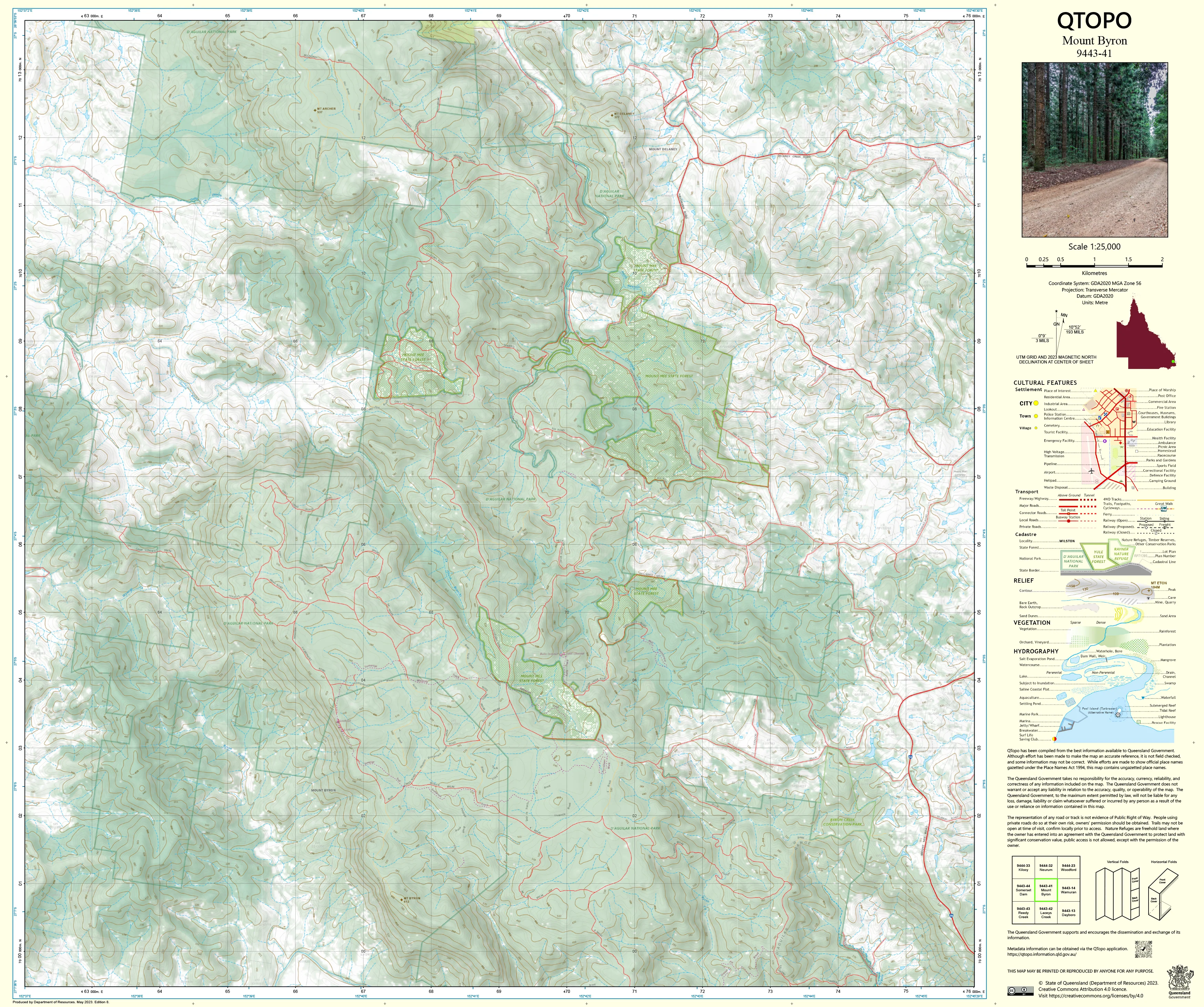
9443-41 Mount Byron QTopo 1:25,000 Topographic Map
QTopo 9443-41 — Mount Byron
1:25,000 Topographic Map
A high-detail topographic map covering the rugged Mount Byron region—an area characterised by steep forested ranges, remote creek systems, deep gullies, narrow spurs, and limited-access ridgelines on the western edge of the D’Aguilar Range. With its dramatic elevation changes and dense bushland, this landscape demands accurate mapping for safe navigation, environmental assessment, conservation management, and emergency field operations.
The QTopo 9443-41 (Mount Byron) sheet—produced by the Queensland Department of Resources—forms part of the authoritative 1:25,000 topographic mapping series. It offers high-precision elevation modelling, hydrology mapping, vegetation distribution, and access detail across one of South East Queensland’s most remote and ecologically rich high-country regions.
Whether you are conducting ecological fieldwork, planning fire-management operations, navigating remote trails, or undertaking wilderness exploration, QTopo 9443-41 provides the clarity and reliability required for confident terrain assessment.
🗺️ Map Content and Features
At 1:25,000 scale—where 1 cm on the map equals 250 m on the ground—this map includes:
-
Contour lines detailing steep mountain slopes, ridges, spur systems, escarpments, and deep creek valleys
-
Hydrology features: Mount Byron Creek, tributaries, gullies, drainage lines, and ephemeral watercourses
-
Access routes such as fire trails, management tracks, ridge access lines, and limited bushwalking routes
-
Infrastructure including fencelines, transmission corridors, communication points, and boundary markers
-
Vegetation mapping showing dense eucalypt forest, woodland, scrub, riparian vegetation, and open pockets
-
Land tenure boundaries: state forest, conservation land, water catchment areas, and adjoining rural properties
-
Named features including Mount Byron, adjacent peaks, creek systems, ridgelines, saddles, and scenic viewpoints
-
Points of interest for rangers, surveyors, ecologists, emergency services, and experienced backcountry navigators
All QTopo sheets are produced from Queensland’s authoritative spatial datasets, ensuring accuracy and consistency throughout the series.
🧭 Who Uses This Map?
The Mount Byron 9443-41 Topographic Map is widely used by:
-
Environmental scientists & ecologists – flora/fauna surveys, habitat analysis, catchment research
-
Rangers & forest managers – conservation planning, fire trails, access management
-
Emergency services & SES – search & rescue, bushfire response, and incident coordination
-
Surveyors & GIS technicians – elevation modelling, boundary clarification, terrain profiling
-
Bushwalkers & remote explorers – navigating rugged ridgelines and steep, forested terrain
-
Outdoor educators – teaching advanced landform interpretation and navigation
A critical mapping tool for both professional and high-experience recreational use.
💧 Field-Ready Options for Rugged & Remote High-Country Terrain
Choose a finish suited to the challenging, steep, and often wet forest environment of the Mount Byron area.
✅ Waterproof & Tearproof Tyvek®
-
Printed on DuPont™ Tyvek®
-
Fully waterproof, tear-resistant, and lightweight
-
Ideal for wet-season trips, creek crossings, and rugged field operations
✅ Laminated Edition
-
Encapsulated in 2 × 80-micron gloss laminate
-
Writeable surface works with whiteboard markers
-
Highly resistant to moisture, mud, dust, and heavy handling
📄 Standard Paper Edition
-
Crisp, high-resolution printing
-
Suitable for office use, planning, study, and occasional field reference
📐 Map Details
Title: QTopo 9443-41 — Mount Byron
Publisher: Queensland Department of Resources
Series: QTopo 1:25,000
Scale: 1:25,000 (1 cm = 250 m)
Dimensions: 710 mm (width) × 594 mm (height)
Coverage: Mount Byron and surrounding high-country terrain, creek systems, ridge networks, forested ranges, and management access routes
Material Options: Paper, laminated, or waterproof Tyvek®
Printed in: Australia
Edition: Latest available (see listing)
📥 QTopo Map Index
Need adjoining D’Aguilar Range or western catchment sheets?
➡️ Provide nearby sheet numbers—such as 9443-31, 9443-42, or 9343-41—and I’ll locate the adjoining maps instantly.
🛒 Ordering & Options
-
Standard folded paper map – ideal for planning, study, and reference
-
Tyvek® waterproof edition – perfect for rugged, wet, and remote fieldwork
-
Laminated edition – reusable, durable, and suited to operational settings
-
Flat (unfolded) maps available for wall or map-board display
🎯 Summary
The QTopo 9443-41 — Mount Byron Topographic Map provides essential detail on terrain, hydrology, vegetation, and access across one of the region’s most rugged and remote upland environments. With accurate 1:25,000 mapping and robust print options, it is indispensable for surveyors, ecologists, rangers, emergency services, and serious bushwalkers.
Plan with purpose.
Navigate with confidence.
Explore with clarity.
Choose your preferred finish today and take the Mount Byron QTopo map into the field with Queensland’s most reliable topographic mapping.
Original: $14.27
-65%$14.27
$4.99Product Information
Product Information
Shipping & Returns
Shipping & Returns
Description
QTopo 9443-41 — Mount Byron
1:25,000 Topographic Map
A high-detail topographic map covering the rugged Mount Byron region—an area characterised by steep forested ranges, remote creek systems, deep gullies, narrow spurs, and limited-access ridgelines on the western edge of the D’Aguilar Range. With its dramatic elevation changes and dense bushland, this landscape demands accurate mapping for safe navigation, environmental assessment, conservation management, and emergency field operations.
The QTopo 9443-41 (Mount Byron) sheet—produced by the Queensland Department of Resources—forms part of the authoritative 1:25,000 topographic mapping series. It offers high-precision elevation modelling, hydrology mapping, vegetation distribution, and access detail across one of South East Queensland’s most remote and ecologically rich high-country regions.
Whether you are conducting ecological fieldwork, planning fire-management operations, navigating remote trails, or undertaking wilderness exploration, QTopo 9443-41 provides the clarity and reliability required for confident terrain assessment.
🗺️ Map Content and Features
At 1:25,000 scale—where 1 cm on the map equals 250 m on the ground—this map includes:
-
Contour lines detailing steep mountain slopes, ridges, spur systems, escarpments, and deep creek valleys
-
Hydrology features: Mount Byron Creek, tributaries, gullies, drainage lines, and ephemeral watercourses
-
Access routes such as fire trails, management tracks, ridge access lines, and limited bushwalking routes
-
Infrastructure including fencelines, transmission corridors, communication points, and boundary markers
-
Vegetation mapping showing dense eucalypt forest, woodland, scrub, riparian vegetation, and open pockets
-
Land tenure boundaries: state forest, conservation land, water catchment areas, and adjoining rural properties
-
Named features including Mount Byron, adjacent peaks, creek systems, ridgelines, saddles, and scenic viewpoints
-
Points of interest for rangers, surveyors, ecologists, emergency services, and experienced backcountry navigators
All QTopo sheets are produced from Queensland’s authoritative spatial datasets, ensuring accuracy and consistency throughout the series.
🧭 Who Uses This Map?
The Mount Byron 9443-41 Topographic Map is widely used by:
-
Environmental scientists & ecologists – flora/fauna surveys, habitat analysis, catchment research
-
Rangers & forest managers – conservation planning, fire trails, access management
-
Emergency services & SES – search & rescue, bushfire response, and incident coordination
-
Surveyors & GIS technicians – elevation modelling, boundary clarification, terrain profiling
-
Bushwalkers & remote explorers – navigating rugged ridgelines and steep, forested terrain
-
Outdoor educators – teaching advanced landform interpretation and navigation
A critical mapping tool for both professional and high-experience recreational use.
💧 Field-Ready Options for Rugged & Remote High-Country Terrain
Choose a finish suited to the challenging, steep, and often wet forest environment of the Mount Byron area.
✅ Waterproof & Tearproof Tyvek®
-
Printed on DuPont™ Tyvek®
-
Fully waterproof, tear-resistant, and lightweight
-
Ideal for wet-season trips, creek crossings, and rugged field operations
✅ Laminated Edition
-
Encapsulated in 2 × 80-micron gloss laminate
-
Writeable surface works with whiteboard markers
-
Highly resistant to moisture, mud, dust, and heavy handling
📄 Standard Paper Edition
-
Crisp, high-resolution printing
-
Suitable for office use, planning, study, and occasional field reference
📐 Map Details
Title: QTopo 9443-41 — Mount Byron
Publisher: Queensland Department of Resources
Series: QTopo 1:25,000
Scale: 1:25,000 (1 cm = 250 m)
Dimensions: 710 mm (width) × 594 mm (height)
Coverage: Mount Byron and surrounding high-country terrain, creek systems, ridge networks, forested ranges, and management access routes
Material Options: Paper, laminated, or waterproof Tyvek®
Printed in: Australia
Edition: Latest available (see listing)
📥 QTopo Map Index
Need adjoining D’Aguilar Range or western catchment sheets?
➡️ Provide nearby sheet numbers—such as 9443-31, 9443-42, or 9343-41—and I’ll locate the adjoining maps instantly.
🛒 Ordering & Options
-
Standard folded paper map – ideal for planning, study, and reference
-
Tyvek® waterproof edition – perfect for rugged, wet, and remote fieldwork
-
Laminated edition – reusable, durable, and suited to operational settings
-
Flat (unfolded) maps available for wall or map-board display
🎯 Summary
The QTopo 9443-41 — Mount Byron Topographic Map provides essential detail on terrain, hydrology, vegetation, and access across one of the region’s most rugged and remote upland environments. With accurate 1:25,000 mapping and robust print options, it is indispensable for surveyors, ecologists, rangers, emergency services, and serious bushwalkers.
Plan with purpose.
Navigate with confidence.
Explore with clarity.
Choose your preferred finish today and take the Mount Byron QTopo map into the field with Queensland’s most reliable topographic mapping.


