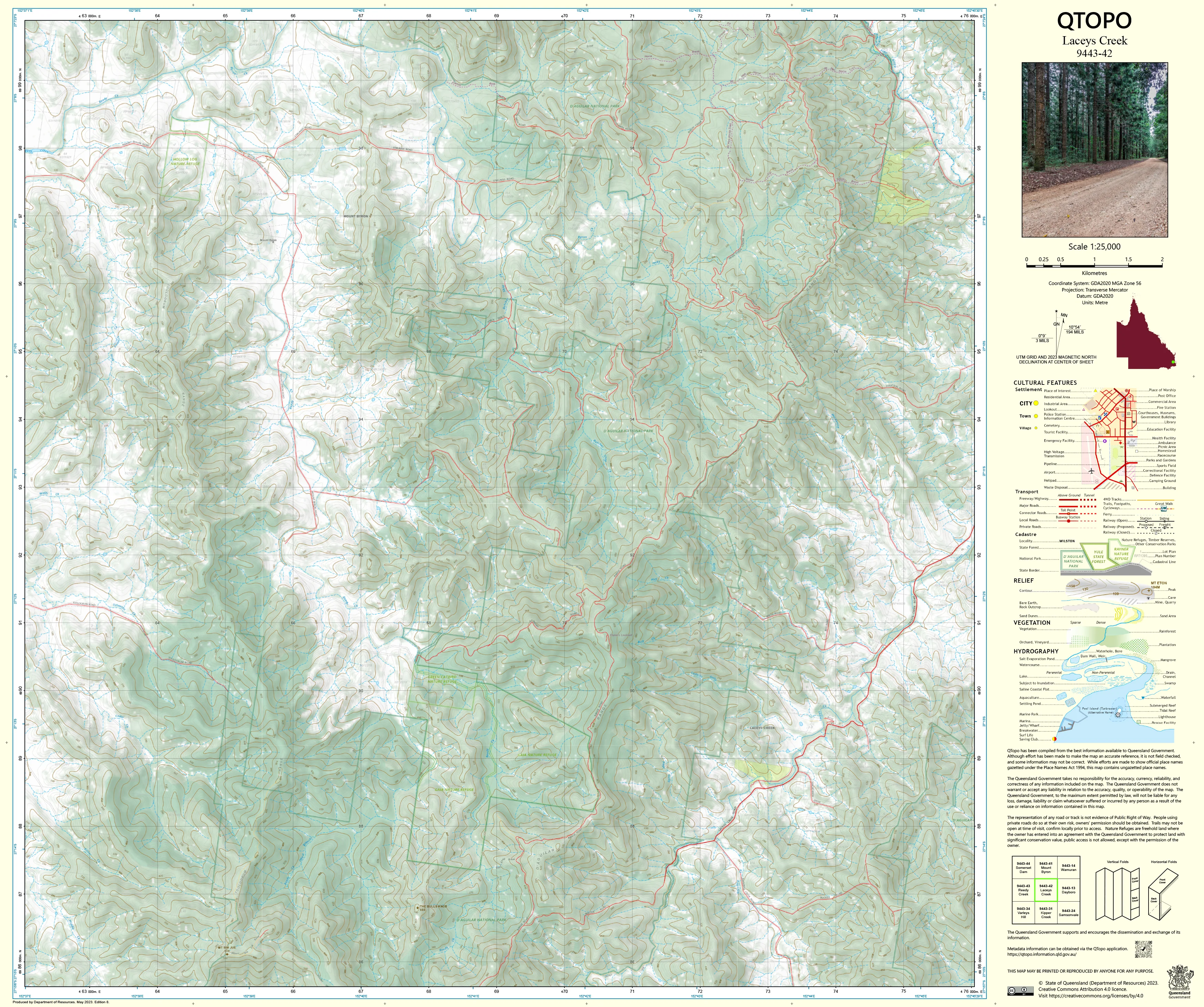
9443-42 Laceys Creek QTopo 1:25,000 Topographic Map
QTopo 9443-42 — Laceys Creek
1:25,000 Topographic Map
A high-detail topographic map covering the Laceys Creek region—an area of steep valleys, forested ridgelines, rural properties, and remote creek systems on the southeastern edge of the D’Aguilar Range. Known for its winding access roads, dense eucalypt forest, rugged terrain, and scattered rural homesteads, this is a landscape where precise mapping is essential for land management, environmental work, emergency response, and confident off-road navigation.
The QTopo 9443-42 (Laceys Creek) sheet—produced by the Queensland Department of Resources—is part of Queensland’s authoritative 1:25,000 topographic mapping series. It delivers detailed elevation modelling, hydrology mapping, vegetation classification, and access route information across one of the Moreton Bay region’s most ecologically significant and topographically complex rural districts.
Whether you're conducting ecological field surveys, planning bushfire operations, navigating remote backroads, or undertaking conservation work, QTopo 9443-42 provides the accuracy and clarity needed for informed, safe decision-making.
🗺️ Map Content and Features
At 1:25,000 scale—where 1 cm = 250 m—this map includes:
-
Contour lines depicting steep slopes, narrow ridgelines, saddle points, deep valleys, and elevated forest terrain
-
Hydrology features: Laceys Creek, tributaries, ephemeral streams, drainage lines, and waterholes
-
Access routes such as rural roads, fire trails, management tracks, and limited bushwalking paths
-
Infrastructure including powerlines, fencelines, farm buildings, communication sites, and property boundaries
-
Vegetation mapping showing dense woodland, eucalypt forest, open patches, grassland pockets, and riparian zones
-
Land tenure boundaries: freehold rural land, conservation areas, state-managed forest, and adjacent catchment lands
-
Named features including ridges, summits, localities, creek systems, and remote viewpoints
-
Points of interest for surveyors, ecologists, rangers, rural landholders, and emergency services
All QTopo mapping is generated from Queensland’s authoritative spatial datasets, ensuring accuracy and consistency across the entire series.
🧭 Who Uses This Map?
The Laceys Creek 9443-42 Topographic Map is widely used by:
-
Environmental scientists & ecologists – habitat assessment, flora/fauna surveys, riparian studies
-
Rangers & forest managers – fire planning, track management, and conservation work
-
Emergency services & SES – search & rescue, bushfire response, flood modelling
-
Surveyors & GIS practitioners – contour analysis, boundary interpretation, terrain profiling
-
Rural landholders & graziers – property planning, water management, access evaluation
-
Bushwalkers & off-road explorers – navigating remote, steep, and heavily forested terrain
-
Outdoor educators – teaching landform interpretation and advanced navigation
An essential tool for both professional and high-level recreational fieldwork.
💧 Field-Ready Options for Rugged, Forested & Rural Terrain
Choose a finish built for the demanding conditions of Laceys Creek’s steep and densely vegetated landscape.
✅ Waterproof & Tearproof Tyvek®
-
Printed on DuPont™ Tyvek®
-
Completely waterproof, tear-resistant, and tough
-
Ideal for wet-season fieldwork, off-track navigation, and rugged creek-country terrain
✅ Laminated Edition
-
Encapsulated in 2 × 80-micron gloss laminate
-
Writeable surface compatible with whiteboard markers
-
Resistant to water, mud, dust, and repeated field handling
📄 Standard Paper Edition
-
Clean, high-resolution printing
-
Suitable for planning, office reference, and occasional field use
📐 Map Details
Title: QTopo 9443-42 — Laceys Creek
Publisher: Queensland Department of Resources
Series: QTopo 1:25,000
Scale: 1:25,000 (1 cm = 250 m)
Dimensions: 710 mm (width) × 594 mm (height)
Coverage: Laceys Creek valley, surrounding hills, forested ridges, rural properties, creek systems, and remote bushland terrain
Material Options: Paper, laminated, or waterproof Tyvek®
Printed in: Australia
Edition: Latest available (see listing)
📥 QTopo Map Index
Need adjoining Moreton Bay or D’Aguilar Range sheets?
➡️ Provide nearby sheet numbers—such as 9443-41, 9443-32, or 9343-42—and I’ll identify the adjoining maps instantly.
🛒 Ordering & Options
-
Standard folded paper map – ideal for planning, study, and reference
-
Tyvek® waterproof edition – excellent for rugged, wet, and forested field environments
-
Laminated edition – reusable, durable, and ideal for operational teams and conservation work
-
Flat (unfolded) maps available for wall or map-board use
🎯 Summary
The QTopo 9443-42 — Laceys Creek Topographic Map provides essential detail on terrain, hydrology, vegetation, and rural access across one of the region’s most rugged and steeply forested landscapes. With authoritative 1:25,000 mapping and tough field-ready printing options, it is indispensable for rangers, ecologists, surveyors, emergency services, and advanced bush navigators.
Plan with purpose.
Navigate with confidence.
Explore with clarity.
Choose your preferred finish today and take the Laceys Creek QTopo map into the field with Queensland’s most trusted topographic mapping.
Original: $14.27
-65%$14.27
$4.99Product Information
Product Information
Shipping & Returns
Shipping & Returns
Description
QTopo 9443-42 — Laceys Creek
1:25,000 Topographic Map
A high-detail topographic map covering the Laceys Creek region—an area of steep valleys, forested ridgelines, rural properties, and remote creek systems on the southeastern edge of the D’Aguilar Range. Known for its winding access roads, dense eucalypt forest, rugged terrain, and scattered rural homesteads, this is a landscape where precise mapping is essential for land management, environmental work, emergency response, and confident off-road navigation.
The QTopo 9443-42 (Laceys Creek) sheet—produced by the Queensland Department of Resources—is part of Queensland’s authoritative 1:25,000 topographic mapping series. It delivers detailed elevation modelling, hydrology mapping, vegetation classification, and access route information across one of the Moreton Bay region’s most ecologically significant and topographically complex rural districts.
Whether you're conducting ecological field surveys, planning bushfire operations, navigating remote backroads, or undertaking conservation work, QTopo 9443-42 provides the accuracy and clarity needed for informed, safe decision-making.
🗺️ Map Content and Features
At 1:25,000 scale—where 1 cm = 250 m—this map includes:
-
Contour lines depicting steep slopes, narrow ridgelines, saddle points, deep valleys, and elevated forest terrain
-
Hydrology features: Laceys Creek, tributaries, ephemeral streams, drainage lines, and waterholes
-
Access routes such as rural roads, fire trails, management tracks, and limited bushwalking paths
-
Infrastructure including powerlines, fencelines, farm buildings, communication sites, and property boundaries
-
Vegetation mapping showing dense woodland, eucalypt forest, open patches, grassland pockets, and riparian zones
-
Land tenure boundaries: freehold rural land, conservation areas, state-managed forest, and adjacent catchment lands
-
Named features including ridges, summits, localities, creek systems, and remote viewpoints
-
Points of interest for surveyors, ecologists, rangers, rural landholders, and emergency services
All QTopo mapping is generated from Queensland’s authoritative spatial datasets, ensuring accuracy and consistency across the entire series.
🧭 Who Uses This Map?
The Laceys Creek 9443-42 Topographic Map is widely used by:
-
Environmental scientists & ecologists – habitat assessment, flora/fauna surveys, riparian studies
-
Rangers & forest managers – fire planning, track management, and conservation work
-
Emergency services & SES – search & rescue, bushfire response, flood modelling
-
Surveyors & GIS practitioners – contour analysis, boundary interpretation, terrain profiling
-
Rural landholders & graziers – property planning, water management, access evaluation
-
Bushwalkers & off-road explorers – navigating remote, steep, and heavily forested terrain
-
Outdoor educators – teaching landform interpretation and advanced navigation
An essential tool for both professional and high-level recreational fieldwork.
💧 Field-Ready Options for Rugged, Forested & Rural Terrain
Choose a finish built for the demanding conditions of Laceys Creek’s steep and densely vegetated landscape.
✅ Waterproof & Tearproof Tyvek®
-
Printed on DuPont™ Tyvek®
-
Completely waterproof, tear-resistant, and tough
-
Ideal for wet-season fieldwork, off-track navigation, and rugged creek-country terrain
✅ Laminated Edition
-
Encapsulated in 2 × 80-micron gloss laminate
-
Writeable surface compatible with whiteboard markers
-
Resistant to water, mud, dust, and repeated field handling
📄 Standard Paper Edition
-
Clean, high-resolution printing
-
Suitable for planning, office reference, and occasional field use
📐 Map Details
Title: QTopo 9443-42 — Laceys Creek
Publisher: Queensland Department of Resources
Series: QTopo 1:25,000
Scale: 1:25,000 (1 cm = 250 m)
Dimensions: 710 mm (width) × 594 mm (height)
Coverage: Laceys Creek valley, surrounding hills, forested ridges, rural properties, creek systems, and remote bushland terrain
Material Options: Paper, laminated, or waterproof Tyvek®
Printed in: Australia
Edition: Latest available (see listing)
📥 QTopo Map Index
Need adjoining Moreton Bay or D’Aguilar Range sheets?
➡️ Provide nearby sheet numbers—such as 9443-41, 9443-32, or 9343-42—and I’ll identify the adjoining maps instantly.
🛒 Ordering & Options
-
Standard folded paper map – ideal for planning, study, and reference
-
Tyvek® waterproof edition – excellent for rugged, wet, and forested field environments
-
Laminated edition – reusable, durable, and ideal for operational teams and conservation work
-
Flat (unfolded) maps available for wall or map-board use
🎯 Summary
The QTopo 9443-42 — Laceys Creek Topographic Map provides essential detail on terrain, hydrology, vegetation, and rural access across one of the region’s most rugged and steeply forested landscapes. With authoritative 1:25,000 mapping and tough field-ready printing options, it is indispensable for rangers, ecologists, surveyors, emergency services, and advanced bush navigators.
Plan with purpose.
Navigate with confidence.
Explore with clarity.
Choose your preferred finish today and take the Laceys Creek QTopo map into the field with Queensland’s most trusted topographic mapping.


