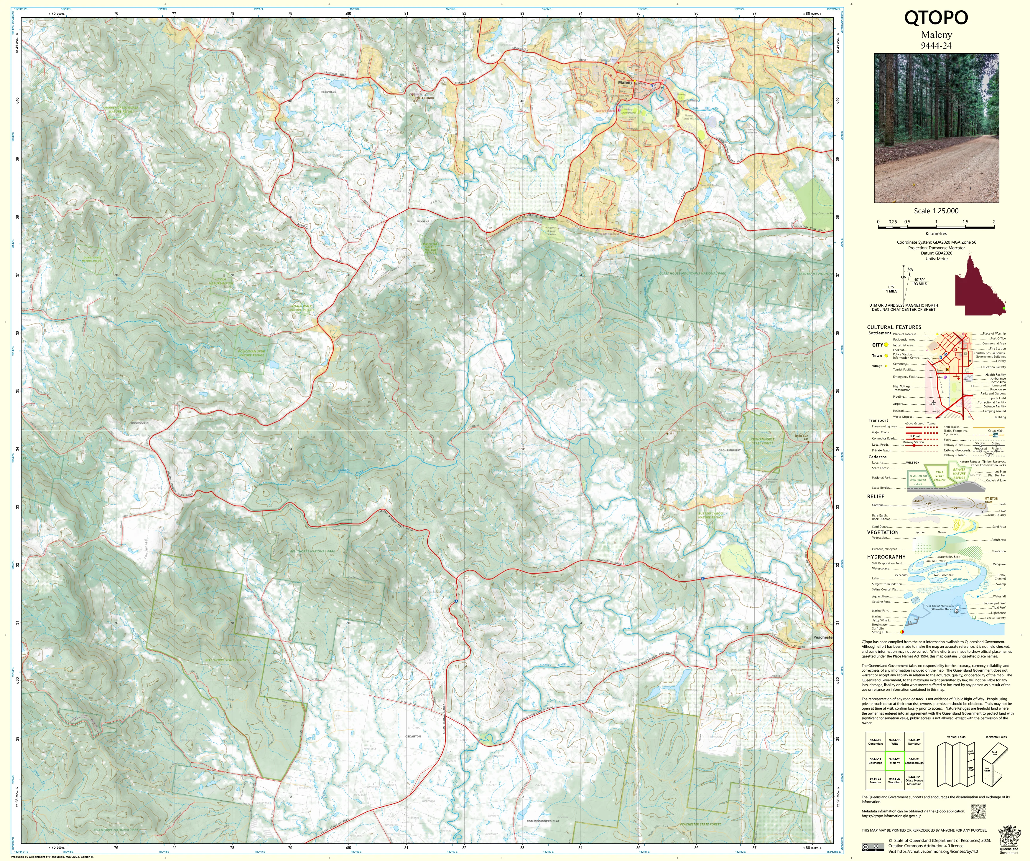
9444-24 Maleny QTopo 1:25,000 Topographic Map
QTopo 9444-24 — Maleny
1:25,000 Topographic Map
A high-detail topographic map covering the Maleny region—one of the Sunshine Coast hinterland’s most scenic and environmentally significant areas. Defined by rolling green hills, volcanic plateaus, rainforest remnants, deep creek valleys, dairy country, and panoramic escarpments, Maleny demands accurate mapping for environmental work, rural planning, emergency response, and outdoor exploration.
The QTopo 9444-24 (Maleny) sheet—produced by the Queensland Department of Resources—is part of the authoritative 1:25,000 statewide mapping series. It provides precise elevation modelling, hydrology detail, vegetation classification, and infrastructure mapping across a landscape renowned for its natural beauty and complex terrain.
Whether you’re monitoring catchments, navigating hinterland backroads, assessing rural land, or exploring bushwalks and viewpoints, QTopo 9444-24 delivers the accuracy and clarity essential for confident decision-making.
🗺️ Map Content and Features
At 1:25,000 scale—with 1 cm on the map representing 250 m on the ground—this map includes:
-
Contour lines showing rolling hills, escarpments, ridges, gullies, and high plateaus
-
Hydrology features: Obi Obi Creek, tributaries, waterfalls, drainage lines, wetlands, and waterholes
-
Road networks & rural access tracks connecting townships, farms, scenic drives, reserves, and hinterland communities
-
Infrastructure including schools, fencelines, powerlines, lookout areas, community facilities, and agricultural structures
-
Vegetation mapping covering rainforest patches, eucalypt forest, woodland, pasture, plantations, and riparian corridors
-
Land tenure boundaries: freehold farmland, conservation lands, council reserves, and state forest
-
Named features including hills, creeks, ridgelines, parks, localities, and scenic viewing areas
-
Points of interest for surveyors, planners, ecologists, rangers, emergency services, and travellers
All QTopo maps are generated from Queensland’s authoritative spatial datasets for accuracy and consistency.
🧭 Who Uses This Map?
The Maleny 9444-24 Topographic Map is widely used by:
-
Environmental scientists & ecologists – habitat mapping, water-quality studies, catchment modelling
-
Surveyors & land planners – boundary assessment, rural land-use planning, terrain interpretation
-
Emergency services & SES – flood modelling, bushfire response, incident navigation
-
Farmers & rural property owners – infrastructure planning, water management, paddock design
-
Outdoor explorers & hikers – navigating hinterland tracks, scenic lookouts, and reserve areas
-
Local government & utilities – infrastructure planning and environmental management
-
Educators & students – studying geography, landscape processes, and topographic interpretation
A versatile and indispensable reference for both professional and recreational users.
💧 Field-Ready Options for Hinterland, Rural & Creek Valley Terrain
Choose a finish suited to Maleny’s mixed agricultural and forested environment.
✅ Waterproof & Tearproof Tyvek®
-
Printed on DuPont™ Tyvek®
-
Fully waterproof, tear-resistant, and durable
-
Ideal for wet-season fieldwork, creek surveys, and rugged hinterland conditions
✅ Laminated Edition
-
Encapsulated in 2 × 80-micron gloss laminate
-
Writeable surface compatible with whiteboard markers
-
Resistant to moisture, dirt, dust, and heavy handling
📄 Standard Paper Edition
-
Crisp, high-resolution printing
-
Suitable for planning, office reference, and general mapping study
📐 Map Details
Title: QTopo 9444-24 — Maleny
Publisher: Queensland Department of Resources
Series: QTopo 1:25,000
Scale: 1:25,000 (1 cm = 250 m)
Dimensions: 710 mm (width) × 594 mm (height)
Coverage: Maleny township, Obi Obi Creek valley, surrounding farmland, plateaus, escarpments, forest patches, and hinterland road networks
Material Options: Paper, laminated, or waterproof Tyvek®
Printed in: Australia
Edition: Latest available (see listing)
📥 QTopo Map Index
Need adjoining hinterland or Sunshine Coast sheets?
➡️ Provide nearby sheet numbers—such as 9444-23, 9444-25, or 9344-24—and I’ll identify the adjoining maps instantly.
🛒 Ordering & Options
-
Standard folded paper map – excellent for planning, research, and general reference
-
Tyvek® waterproof edition – ideal for rugged fieldwork and wet hinterland conditions
-
Laminated edition – reusable, durable, and suited to operational, educational, and environmental applications
-
Flat (unfolded) maps available for wall or map-board display
🎯 Summary
The QTopo 9444-24 — Maleny Topographic Map provides essential detail on terrain, hydrology, vegetation, land use, and access across one of the Sunshine Coast hinterland’s most iconic rural landscapes. With authoritative 1:25,000 mapping and rugged print options, it is indispensable for ecologists, planners, surveyors, emergency teams, farmers, and nature lovers.
Plan with purpose.
Navigate with confidence.
Explore with clarity.
Choose your preferred finish today and take the Maleny QTopo map into the field with Queensland’s most trusted topographic mapping.
Product Information
Product Information
Shipping & Returns
Shipping & Returns
Description
QTopo 9444-24 — Maleny
1:25,000 Topographic Map
A high-detail topographic map covering the Maleny region—one of the Sunshine Coast hinterland’s most scenic and environmentally significant areas. Defined by rolling green hills, volcanic plateaus, rainforest remnants, deep creek valleys, dairy country, and panoramic escarpments, Maleny demands accurate mapping for environmental work, rural planning, emergency response, and outdoor exploration.
The QTopo 9444-24 (Maleny) sheet—produced by the Queensland Department of Resources—is part of the authoritative 1:25,000 statewide mapping series. It provides precise elevation modelling, hydrology detail, vegetation classification, and infrastructure mapping across a landscape renowned for its natural beauty and complex terrain.
Whether you’re monitoring catchments, navigating hinterland backroads, assessing rural land, or exploring bushwalks and viewpoints, QTopo 9444-24 delivers the accuracy and clarity essential for confident decision-making.
🗺️ Map Content and Features
At 1:25,000 scale—with 1 cm on the map representing 250 m on the ground—this map includes:
-
Contour lines showing rolling hills, escarpments, ridges, gullies, and high plateaus
-
Hydrology features: Obi Obi Creek, tributaries, waterfalls, drainage lines, wetlands, and waterholes
-
Road networks & rural access tracks connecting townships, farms, scenic drives, reserves, and hinterland communities
-
Infrastructure including schools, fencelines, powerlines, lookout areas, community facilities, and agricultural structures
-
Vegetation mapping covering rainforest patches, eucalypt forest, woodland, pasture, plantations, and riparian corridors
-
Land tenure boundaries: freehold farmland, conservation lands, council reserves, and state forest
-
Named features including hills, creeks, ridgelines, parks, localities, and scenic viewing areas
-
Points of interest for surveyors, planners, ecologists, rangers, emergency services, and travellers
All QTopo maps are generated from Queensland’s authoritative spatial datasets for accuracy and consistency.
🧭 Who Uses This Map?
The Maleny 9444-24 Topographic Map is widely used by:
-
Environmental scientists & ecologists – habitat mapping, water-quality studies, catchment modelling
-
Surveyors & land planners – boundary assessment, rural land-use planning, terrain interpretation
-
Emergency services & SES – flood modelling, bushfire response, incident navigation
-
Farmers & rural property owners – infrastructure planning, water management, paddock design
-
Outdoor explorers & hikers – navigating hinterland tracks, scenic lookouts, and reserve areas
-
Local government & utilities – infrastructure planning and environmental management
-
Educators & students – studying geography, landscape processes, and topographic interpretation
A versatile and indispensable reference for both professional and recreational users.
💧 Field-Ready Options for Hinterland, Rural & Creek Valley Terrain
Choose a finish suited to Maleny’s mixed agricultural and forested environment.
✅ Waterproof & Tearproof Tyvek®
-
Printed on DuPont™ Tyvek®
-
Fully waterproof, tear-resistant, and durable
-
Ideal for wet-season fieldwork, creek surveys, and rugged hinterland conditions
✅ Laminated Edition
-
Encapsulated in 2 × 80-micron gloss laminate
-
Writeable surface compatible with whiteboard markers
-
Resistant to moisture, dirt, dust, and heavy handling
📄 Standard Paper Edition
-
Crisp, high-resolution printing
-
Suitable for planning, office reference, and general mapping study
📐 Map Details
Title: QTopo 9444-24 — Maleny
Publisher: Queensland Department of Resources
Series: QTopo 1:25,000
Scale: 1:25,000 (1 cm = 250 m)
Dimensions: 710 mm (width) × 594 mm (height)
Coverage: Maleny township, Obi Obi Creek valley, surrounding farmland, plateaus, escarpments, forest patches, and hinterland road networks
Material Options: Paper, laminated, or waterproof Tyvek®
Printed in: Australia
Edition: Latest available (see listing)
📥 QTopo Map Index
Need adjoining hinterland or Sunshine Coast sheets?
➡️ Provide nearby sheet numbers—such as 9444-23, 9444-25, or 9344-24—and I’ll identify the adjoining maps instantly.
🛒 Ordering & Options
-
Standard folded paper map – excellent for planning, research, and general reference
-
Tyvek® waterproof edition – ideal for rugged fieldwork and wet hinterland conditions
-
Laminated edition – reusable, durable, and suited to operational, educational, and environmental applications
-
Flat (unfolded) maps available for wall or map-board display
🎯 Summary
The QTopo 9444-24 — Maleny Topographic Map provides essential detail on terrain, hydrology, vegetation, land use, and access across one of the Sunshine Coast hinterland’s most iconic rural landscapes. With authoritative 1:25,000 mapping and rugged print options, it is indispensable for ecologists, planners, surveyors, emergency teams, farmers, and nature lovers.
Plan with purpose.
Navigate with confidence.
Explore with clarity.
Choose your preferred finish today and take the Maleny QTopo map into the field with Queensland’s most trusted topographic mapping.


