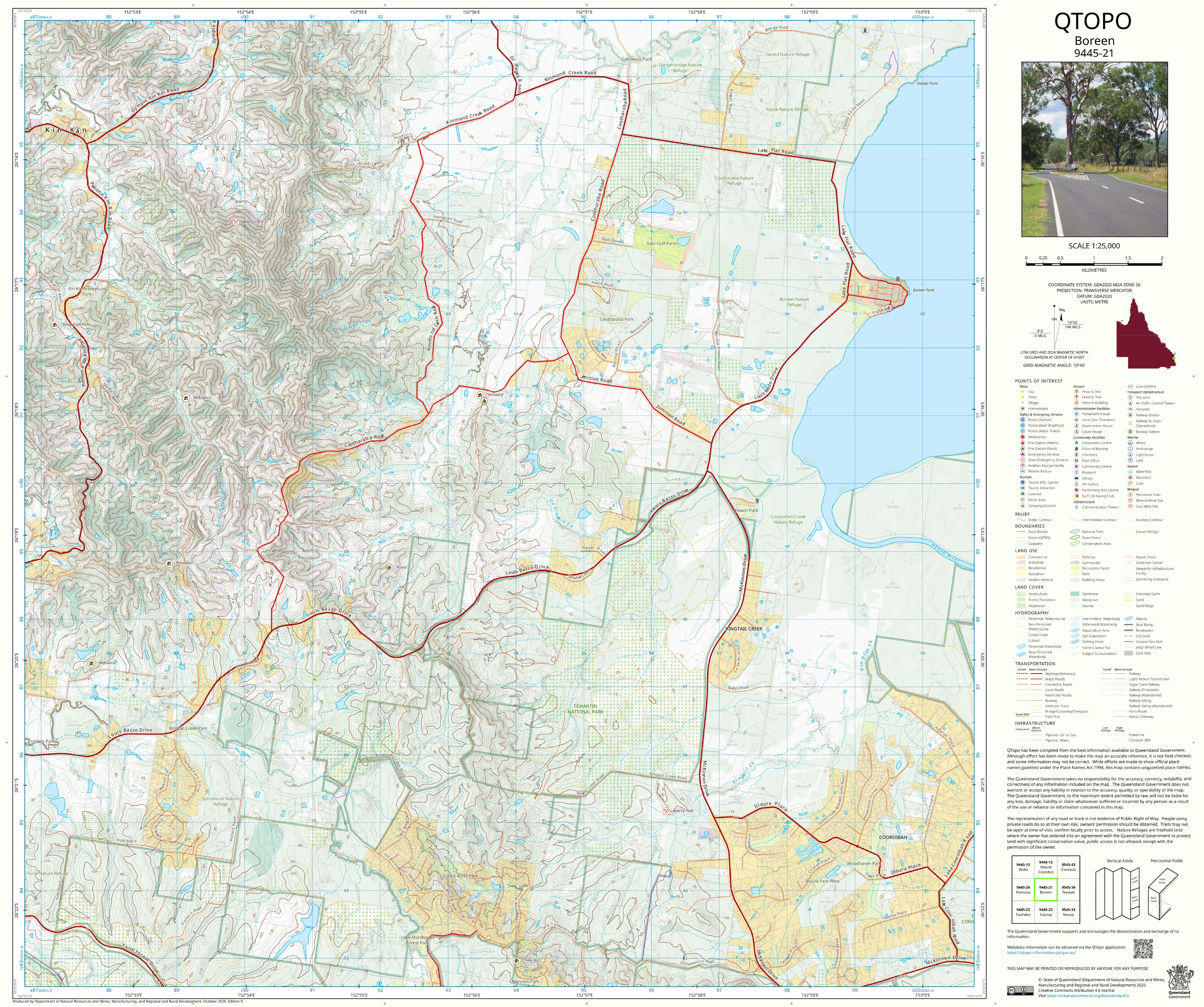
9445-21 Boreen QTopo 1:25,000 Topographic Map
QTopo 9445-21 — Boreen
1:25,000 Topographic Map
A detailed and authoritative topographic map covering the Boreen region—an area defined by its mosaic of wetlands, waterways, forested hills, rural properties, and proximity to the Noosa hinterland. From the edge of Lake Cootharaba to the low forested rises and fertile creek flats, this landscape demands accurate mapping for environmental work, rural management, recreation, planning, and emergency response.
The QTopo 9445-21 (Boreen) sheet—produced by the Queensland Department of Resources—is part of the state’s official 1:25,000 mapping series. It presents high-precision elevation contours, hydrology networks, vegetation classification, infrastructure mapping, and access detail across one of the Sunshine Coast’s most ecologically sensitive and visually distinctive regions.
Whether you’re monitoring wetlands, navigating rural access tracks, planning property development, conducting ecological studies, or exploring the hinterland, QTopo 9445-21 provides the reliability and clarity required for confident decision-making.
🗺️ Map Content and Features
At 1:25,000 scale—where 1 cm = 250 m—this map includes:
-
Contour lines showing low rises, gentle hills, alluvial flats, wetland margins, and subtle terrain changes
-
Hydrology features: Boreen Point surrounds, feeder creeks, drainage lines, swamps, wetlands, riparian corridors, and waterholes
-
Road and track networks including rural roads, forestry tracks, recreation access routes, and local connectivity
-
Infrastructure such as fencelines, powerlines, lookout points, campgrounds, jetties, rural buildings, and recreation facilities
-
Vegetation mapping capturing woodland, forest, heath, wetland vegetation, melaleuca stands, and cleared rural land
-
Land tenure boundaries: national park, conservation areas, council land, freehold properties, and state-managed tenure
-
Named features including Boreen Point, Lake Cootharaba margins, creek systems, localities, reserves, and viewpoints
-
Points of interest for ecologists, planners, emergency services, paddlers, bushwalkers, and local landholders
Every QTopo product is based on Queensland’s authoritative spatial datasets, ensuring accuracy and consistency throughout the mapping series.
🧭 Who Uses This Map?
The Boreen 9445-21 Topographic Map is commonly used by:
-
Environmental scientists & ecologists – wetland studies, habitat monitoring, hydrological research
-
Surveyors & planners – development assessment, landscape analysis, boundary interpretation
-
Rangers & emergency services – search & rescue, bushfire planning, flood response
-
Kayakers, bushwalkers & outdoor explorers – navigating tracks, lake edges, and hinterland routes
-
Rural landholders – property planning, infrastructure placement, water management
-
Educators & students – studying geography, ecology, and regional landforms
An essential reference for both professional and recreational users.
💧 Field-Ready Options for Wetlands, Forest & Rural Terrain
Choose a durable finish suited to Boreen’s mix of wet and dry environments.
✅ Waterproof & Tearproof Tyvek®
-
Printed on DuPont™ Tyvek®
-
Fully waterproof, lightweight, and tear-resistant
-
Ideal for wetland surveys, lake-edge work, and all-weather field operations
✅ Laminated Edition
-
Encapsulated in 2 × 80-micron gloss laminate
-
Writeable surface compatible with whiteboard markers
-
Resistant to moisture, mud, oils, and heavy handling
📄 Standard Paper Edition
-
Clean high-resolution printing
-
Best for office reference, planning, and study
📐 Map Details
Title: QTopo 9445-21 — Boreen
Publisher: Queensland Department of Resources
Series: QTopo 1:25,000
Scale: 1:25,000 (1 cm = 250 m)
Dimensions: 710 mm (width) × 594 mm (height)
Coverage: Boreen Point surrounds, wetlands, Lake Cootharaba margins, hinterland forest, rural land, and local road networks
Material Options: Paper, laminated, or waterproof Tyvek®
Printed in: Australia
Edition: Latest available (see listing)
📥 QTopo Map Index
Looking for adjoining Noosa Hinterland or Cooloola region sheets?
➡️ Provide nearby sheet numbers—such as 9445-11, 9445-22, or 9345-21—and I’ll identify the adjoining maps instantly.
🛒 Ordering & Options
-
Standard folded paper map – excellent for planning and local reference
-
Tyvek® waterproof edition – perfect for wetland, lakeside, and all-weather fieldwork
-
Laminated edition – durable, reusable, and ideal for operational or educational use
-
Flat (unfolded) maps available for workshops, offices, and wall mounting
🎯 Summary
The QTopo 9445-21 — Boreen Topographic Map provides essential detail on terrain, hydrology, vegetation, access, and land use across a region rich in ecological value and recreational significance. With accurate 1:25,000 mapping and robust printing options, it is the ideal resource for ecologists, surveyors, emergency teams, landholders, and outdoor enthusiasts.
Plan with purpose.
Navigate with confidence.
Explore with clarity.
Choose your preferred finish today and take the Boreen QTopo map into the field with Queensland’s most trusted topographic mapping.
Product Information
Product Information
Shipping & Returns
Shipping & Returns
Description
QTopo 9445-21 — Boreen
1:25,000 Topographic Map
A detailed and authoritative topographic map covering the Boreen region—an area defined by its mosaic of wetlands, waterways, forested hills, rural properties, and proximity to the Noosa hinterland. From the edge of Lake Cootharaba to the low forested rises and fertile creek flats, this landscape demands accurate mapping for environmental work, rural management, recreation, planning, and emergency response.
The QTopo 9445-21 (Boreen) sheet—produced by the Queensland Department of Resources—is part of the state’s official 1:25,000 mapping series. It presents high-precision elevation contours, hydrology networks, vegetation classification, infrastructure mapping, and access detail across one of the Sunshine Coast’s most ecologically sensitive and visually distinctive regions.
Whether you’re monitoring wetlands, navigating rural access tracks, planning property development, conducting ecological studies, or exploring the hinterland, QTopo 9445-21 provides the reliability and clarity required for confident decision-making.
🗺️ Map Content and Features
At 1:25,000 scale—where 1 cm = 250 m—this map includes:
-
Contour lines showing low rises, gentle hills, alluvial flats, wetland margins, and subtle terrain changes
-
Hydrology features: Boreen Point surrounds, feeder creeks, drainage lines, swamps, wetlands, riparian corridors, and waterholes
-
Road and track networks including rural roads, forestry tracks, recreation access routes, and local connectivity
-
Infrastructure such as fencelines, powerlines, lookout points, campgrounds, jetties, rural buildings, and recreation facilities
-
Vegetation mapping capturing woodland, forest, heath, wetland vegetation, melaleuca stands, and cleared rural land
-
Land tenure boundaries: national park, conservation areas, council land, freehold properties, and state-managed tenure
-
Named features including Boreen Point, Lake Cootharaba margins, creek systems, localities, reserves, and viewpoints
-
Points of interest for ecologists, planners, emergency services, paddlers, bushwalkers, and local landholders
Every QTopo product is based on Queensland’s authoritative spatial datasets, ensuring accuracy and consistency throughout the mapping series.
🧭 Who Uses This Map?
The Boreen 9445-21 Topographic Map is commonly used by:
-
Environmental scientists & ecologists – wetland studies, habitat monitoring, hydrological research
-
Surveyors & planners – development assessment, landscape analysis, boundary interpretation
-
Rangers & emergency services – search & rescue, bushfire planning, flood response
-
Kayakers, bushwalkers & outdoor explorers – navigating tracks, lake edges, and hinterland routes
-
Rural landholders – property planning, infrastructure placement, water management
-
Educators & students – studying geography, ecology, and regional landforms
An essential reference for both professional and recreational users.
💧 Field-Ready Options for Wetlands, Forest & Rural Terrain
Choose a durable finish suited to Boreen’s mix of wet and dry environments.
✅ Waterproof & Tearproof Tyvek®
-
Printed on DuPont™ Tyvek®
-
Fully waterproof, lightweight, and tear-resistant
-
Ideal for wetland surveys, lake-edge work, and all-weather field operations
✅ Laminated Edition
-
Encapsulated in 2 × 80-micron gloss laminate
-
Writeable surface compatible with whiteboard markers
-
Resistant to moisture, mud, oils, and heavy handling
📄 Standard Paper Edition
-
Clean high-resolution printing
-
Best for office reference, planning, and study
📐 Map Details
Title: QTopo 9445-21 — Boreen
Publisher: Queensland Department of Resources
Series: QTopo 1:25,000
Scale: 1:25,000 (1 cm = 250 m)
Dimensions: 710 mm (width) × 594 mm (height)
Coverage: Boreen Point surrounds, wetlands, Lake Cootharaba margins, hinterland forest, rural land, and local road networks
Material Options: Paper, laminated, or waterproof Tyvek®
Printed in: Australia
Edition: Latest available (see listing)
📥 QTopo Map Index
Looking for adjoining Noosa Hinterland or Cooloola region sheets?
➡️ Provide nearby sheet numbers—such as 9445-11, 9445-22, or 9345-21—and I’ll identify the adjoining maps instantly.
🛒 Ordering & Options
-
Standard folded paper map – excellent for planning and local reference
-
Tyvek® waterproof edition – perfect for wetland, lakeside, and all-weather fieldwork
-
Laminated edition – durable, reusable, and ideal for operational or educational use
-
Flat (unfolded) maps available for workshops, offices, and wall mounting
🎯 Summary
The QTopo 9445-21 — Boreen Topographic Map provides essential detail on terrain, hydrology, vegetation, access, and land use across a region rich in ecological value and recreational significance. With accurate 1:25,000 mapping and robust printing options, it is the ideal resource for ecologists, surveyors, emergency teams, landholders, and outdoor enthusiasts.
Plan with purpose.
Navigate with confidence.
Explore with clarity.
Choose your preferred finish today and take the Boreen QTopo map into the field with Queensland’s most trusted topographic mapping.


