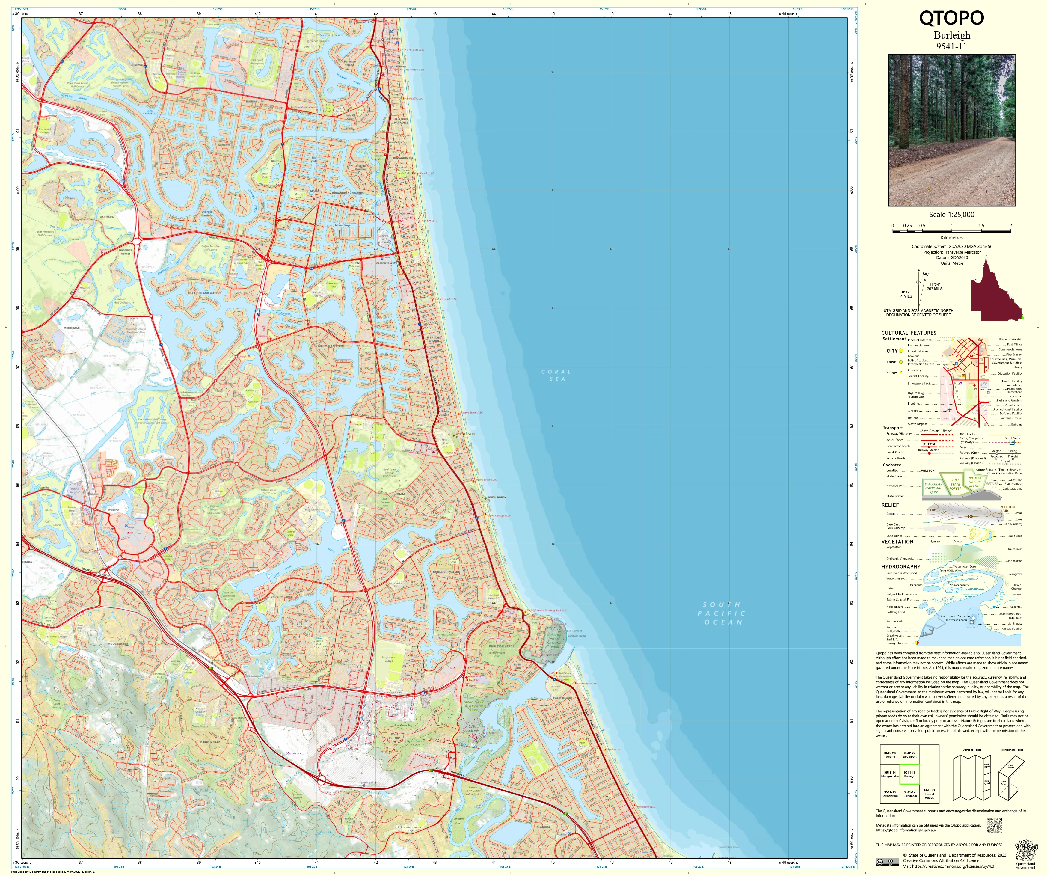
9541-11 Burleigh QTopo 1:25,000 Topographic Map
QTopo 9541-11 — Burleigh
1:25,000 Topographic Map
A detailed topographic map covering the Burleigh region—one of the Gold Coast’s most dynamic coastal landscapes. Encompassing the beaches, headlands, waterways, dense urban areas, hinterland foothills, and conservation reserves that define Burleigh and its surroundings, this map is indispensable for planning, navigation, environmental assessment, and emergency response.
The QTopo 9541-11 (Burleigh) sheet—produced by the Queensland Department of Resources—forms part of the authoritative 1:25,000 statewide topographic series. It provides precise contour mapping, hydrology detail, vegetation structure, and infrastructure information across a region where coastal, urban, and natural environments meet.
Whether you're studying coastal change, navigating parkland trails, planning development, responding to emergencies, or exploring local waterways, QTopo 9541-11 delivers the clarity and reliability needed for confident decision-making.
🗺️ Map Content and Features
At 1:25,000 scale—with 1 cm equalling 250 m—this map includes:
-
Contour lines mapping coastal dunes, headlands, low hills, escarpments, and hinterland slopes
-
Hydrology features: creeks, tidal waterways, lakes, drainage systems, and near-coastal wetlands
-
Urban & transport networks including major roads, residential areas, pedestrian routes, rail corridors, and local streets
-
Coastal features such as beaches, surf zones, Burleigh Headland, rocky foreshores, and access points
-
Infrastructure including powerlines, parks, lookouts, community facilities, surf lifesaving assets, and service structures
-
Vegetation mapping showing coastal heath, rainforest remnants, woodland, reserves, and open green spaces
-
Land tenure boundaries: national park, council reserves, freehold property, and coastal management zones
-
Named features including suburbs, beaches, creeks, headlands, viewpoints, and recreation areas
-
Points of interest for planners, ecologists, surf lifesavers, surveyors, emergency responders, and outdoor users
Every QTopo map is built from Queensland’s authoritative spatial datasets, ensuring consistent and dependable accuracy.
🧭 Who Uses This Map?
The Burleigh 9541-11 Topographic Map is commonly used by:
-
Surveyors & planners – development assessment, zoning review, coastal landform analysis
-
Environmental scientists – wetlands monitoring, dune system studies, coastal vegetation mapping
-
Emergency services – search & rescue, bushfire response, flood modelling, coastal incident management
-
Coastal managers & lifeguards – access planning, hazard assessment, environmental protection
-
Walkers, runners & outdoor enthusiasts – navigating headland circuits, pathways, and reserves
-
Students & educators – studying geography, hydrology, urban form, and coastal ecosystems
A vital planning and navigation resource for urban–coastal environments.
💧 Field-Ready Options for Coastal, Urban & Hinterland Conditions
Choose a finish suitable for the high-use coastal environment around Burleigh.
✅ Waterproof & Tearproof Tyvek®
-
Printed on DuPont™ Tyvek®
-
Fully waterproof, tear-resistant, and durable
-
Excellent for wet-weather fieldwork, coastal monitoring, and outdoor recreation
✅ Laminated Edition
-
Encapsulated in 2 × 80-micron gloss laminate
-
Writeable surface compatible with whiteboard markers
-
Resistant to moisture, salt spray, dirt, and repeated handling
📄 Standard Paper Edition
-
Crisp, high-resolution printing
-
Ideal for office planning, desktop analysis, and study
📐 Map Details
Title: QTopo 9541-11 — Burleigh
Publisher: Queensland Department of Resources
Series: QTopo 1:25,000
Scale: 1:25,000 (1 cm = 250 m)
Dimensions: 710 mm (width) × 594 mm (height)
Coverage: Burleigh Heads, surrounding suburbs, coastal reserves, waterways, urban areas, and hinterland slopes
Material Options: Paper, laminated, or waterproof Tyvek®
Printed in: Australia
Edition: Latest available (refer to listing)
📥 QTopo Map Index
Looking for adjoining Gold Coast or hinterland coverage?
➡️ Provide nearby sheet numbers—such as 9541-12, 9541-21, or 9441-11—and I’ll identify all adjoining maps instantly.
🛒 Ordering & Options
-
Standard folded paper map – ideal for planning, study, and urban analysis
-
Tyvek® waterproof edition – perfect for coastal fieldwork and all-weather use
-
Laminated edition – durable, reusable, and suited to operational teams and educational settings
-
Flat (unfolded) maps available for wall mounting or map-board reference
🎯 Summary
The QTopo 9541-11 — Burleigh Topographic Map provides essential detail on terrain, hydrology, vegetation, urban form, and coastal systems across one of the Gold Coast’s most diverse and rapidly developing regions. With precise 1:25,000 mapping and rugged print options, it is indispensable for surveyors, ecologists, coastal managers, emergency services, lifeguards, and local explorers.
Plan with purpose.
Navigate with confidence.
Explore with clarity.
Choose your preferred finish today and take the Burleigh QTopo map into the field with Queensland’s most trusted topographic mapping.
Product Information
Product Information
Shipping & Returns
Shipping & Returns
Description
QTopo 9541-11 — Burleigh
1:25,000 Topographic Map
A detailed topographic map covering the Burleigh region—one of the Gold Coast’s most dynamic coastal landscapes. Encompassing the beaches, headlands, waterways, dense urban areas, hinterland foothills, and conservation reserves that define Burleigh and its surroundings, this map is indispensable for planning, navigation, environmental assessment, and emergency response.
The QTopo 9541-11 (Burleigh) sheet—produced by the Queensland Department of Resources—forms part of the authoritative 1:25,000 statewide topographic series. It provides precise contour mapping, hydrology detail, vegetation structure, and infrastructure information across a region where coastal, urban, and natural environments meet.
Whether you're studying coastal change, navigating parkland trails, planning development, responding to emergencies, or exploring local waterways, QTopo 9541-11 delivers the clarity and reliability needed for confident decision-making.
🗺️ Map Content and Features
At 1:25,000 scale—with 1 cm equalling 250 m—this map includes:
-
Contour lines mapping coastal dunes, headlands, low hills, escarpments, and hinterland slopes
-
Hydrology features: creeks, tidal waterways, lakes, drainage systems, and near-coastal wetlands
-
Urban & transport networks including major roads, residential areas, pedestrian routes, rail corridors, and local streets
-
Coastal features such as beaches, surf zones, Burleigh Headland, rocky foreshores, and access points
-
Infrastructure including powerlines, parks, lookouts, community facilities, surf lifesaving assets, and service structures
-
Vegetation mapping showing coastal heath, rainforest remnants, woodland, reserves, and open green spaces
-
Land tenure boundaries: national park, council reserves, freehold property, and coastal management zones
-
Named features including suburbs, beaches, creeks, headlands, viewpoints, and recreation areas
-
Points of interest for planners, ecologists, surf lifesavers, surveyors, emergency responders, and outdoor users
Every QTopo map is built from Queensland’s authoritative spatial datasets, ensuring consistent and dependable accuracy.
🧭 Who Uses This Map?
The Burleigh 9541-11 Topographic Map is commonly used by:
-
Surveyors & planners – development assessment, zoning review, coastal landform analysis
-
Environmental scientists – wetlands monitoring, dune system studies, coastal vegetation mapping
-
Emergency services – search & rescue, bushfire response, flood modelling, coastal incident management
-
Coastal managers & lifeguards – access planning, hazard assessment, environmental protection
-
Walkers, runners & outdoor enthusiasts – navigating headland circuits, pathways, and reserves
-
Students & educators – studying geography, hydrology, urban form, and coastal ecosystems
A vital planning and navigation resource for urban–coastal environments.
💧 Field-Ready Options for Coastal, Urban & Hinterland Conditions
Choose a finish suitable for the high-use coastal environment around Burleigh.
✅ Waterproof & Tearproof Tyvek®
-
Printed on DuPont™ Tyvek®
-
Fully waterproof, tear-resistant, and durable
-
Excellent for wet-weather fieldwork, coastal monitoring, and outdoor recreation
✅ Laminated Edition
-
Encapsulated in 2 × 80-micron gloss laminate
-
Writeable surface compatible with whiteboard markers
-
Resistant to moisture, salt spray, dirt, and repeated handling
📄 Standard Paper Edition
-
Crisp, high-resolution printing
-
Ideal for office planning, desktop analysis, and study
📐 Map Details
Title: QTopo 9541-11 — Burleigh
Publisher: Queensland Department of Resources
Series: QTopo 1:25,000
Scale: 1:25,000 (1 cm = 250 m)
Dimensions: 710 mm (width) × 594 mm (height)
Coverage: Burleigh Heads, surrounding suburbs, coastal reserves, waterways, urban areas, and hinterland slopes
Material Options: Paper, laminated, or waterproof Tyvek®
Printed in: Australia
Edition: Latest available (refer to listing)
📥 QTopo Map Index
Looking for adjoining Gold Coast or hinterland coverage?
➡️ Provide nearby sheet numbers—such as 9541-12, 9541-21, or 9441-11—and I’ll identify all adjoining maps instantly.
🛒 Ordering & Options
-
Standard folded paper map – ideal for planning, study, and urban analysis
-
Tyvek® waterproof edition – perfect for coastal fieldwork and all-weather use
-
Laminated edition – durable, reusable, and suited to operational teams and educational settings
-
Flat (unfolded) maps available for wall mounting or map-board reference
🎯 Summary
The QTopo 9541-11 — Burleigh Topographic Map provides essential detail on terrain, hydrology, vegetation, urban form, and coastal systems across one of the Gold Coast’s most diverse and rapidly developing regions. With precise 1:25,000 mapping and rugged print options, it is indispensable for surveyors, ecologists, coastal managers, emergency services, lifeguards, and local explorers.
Plan with purpose.
Navigate with confidence.
Explore with clarity.
Choose your preferred finish today and take the Burleigh QTopo map into the field with Queensland’s most trusted topographic mapping.


