9541-13 Springbrook QTopo 1:25,000 Topographic Map
QTopo 9541-13 — Springbrook
1:25,000 Topographic Map
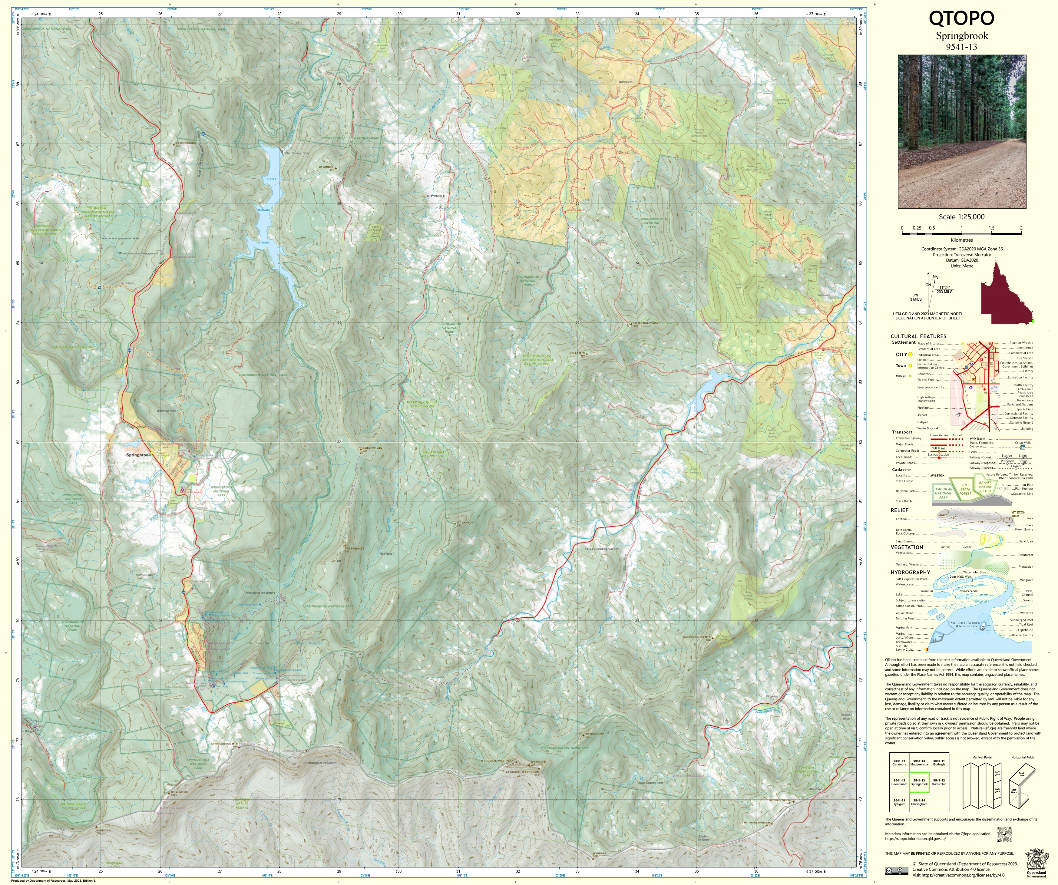
A high-resolution topographic map covering the Springbrook plateau—one of Queensland’s most spectacular upland environments. Featuring sheer escarpments, ancient rainforest, dramatic waterfalls, deep gorges, exposed ridge country, and remote walking tracks, Springbrook is a landscape where accurate mapping is essential for safe navigation, environmental science, emergency operations, and conservation management.
The QTopo 9541-13 (Springbrook) sheet—produced by the Queensland Department of Resources—is part of the official 1:25,000 statewide topographic mapping series. It offers detailed elevation contours, hydrology networks, vegetation structure, access routes, and land tenure information across an area renowned for the “Best of All Lookout”, Natural Bridge, Purling Brook Falls, and World Heritage-listed Gondwana Rainforests.
Whether you're hiking cliff-edge tracks, assessing wildfire risk, conducting ecological fieldwork, or planning visitor access, QTopo 9541-13 delivers the precision and reliability needed for confident terrain interpretation in some of the state’s steepest and most rugged highland terrain.
🗺️ Map Content and Features
At 1:25,000 scale—with 1 cm equalling 250 m—this map provides:
-
Contour lines capturing steep escarpments, plateau rims, ridgelines, saddle points, and deeply incised valleys
-
Hydrology features: Purling Brook, Cave Creek, Twin Falls Creek, drainage lines, waterfalls, and perennial/ephemeral streams
-
Walking tracks & access routes including Springbrook National Park trails, ridge tracks, management roads, and lookout paths
-
Infrastructure such as picnic grounds, trailheads, bridges, viewing platforms, fencelines, and communication sites
-
Vegetation mapping identifying rainforest, wet sclerophyll forest, woodland, heath, regrowth, and riparian vegetation
-
Land tenure boundaries: national park, conservation areas, council reserve, and adjoining freehold properties
-
Named natural features including peaks, cliffs, waterfalls, lookouts, gorges, and plateau landmarks
-
Points of interest for rangers, ecologists, geologists, walkers, emergency services, and visiting researchers
Every QTopo map is compiled from Queensland’s authoritative spatial and elevation datasets to ensure dependable accuracy.
🧭 Who Uses This Map?
The Springbrook 9541-13 Topographic Map is widely used by:
-
Bushwalkers & hikers – navigating challenging terrain and remote cliff-edge trails
-
Environmental scientists & ecologists – World Heritage studies, habitat surveys, hydrology monitoring
-
Rangers & conservation managers – fire planning, access management, visitor safety
-
Emergency services & SES – search & rescue, rapid response planning, incident mapping
-
Surveyors & GIS specialists – terrain analysis, slope assessment, boundary interpretation
-
Outdoor educators & students – teaching navigation, geomorphology, and environmental science
An essential tool for both professional and experienced recreational users.
💧 Field-Ready Options for Steep, Wet & Rainforest Terrain
Choose a finish built to withstand the demanding conditions of the Springbrook plateau.
✅ Waterproof & Tearproof Tyvek®
-
Printed on DuPont™ Tyvek®
-
Completely waterproof, tear-resistant, and lightweight
-
Ideal for wet-weather fieldwork, waterfall environments, and rugged high-altitude trails
✅ Laminated Edition
-
Encapsulated in 2 × 80-micron gloss laminate
-
Writeable surface suitable for whiteboard markers
-
Resistant to moisture, dirt, mist, and repeated heavy handling
📄 Standard Paper Edition
-
Crisp, high-resolution printing
-
Perfect for study, route planning, and office analysis
📐 Map Details
Title: QTopo 9541-13 — Springbrook
Publisher: Queensland Department of Resources
Series: QTopo 1:25,000
Scale: 1:25,000 (1 cm = 250 m)
Dimensions: 710 mm (width) × 594 mm (height)
Coverage: Springbrook plateau, escarpments, waterfalls, rainforest, ridges, creek systems, national park facilities, and surrounding highland access routes
Material Options: Paper, laminated, or waterproof Tyvek®
Printed in: Australia
Edition: Latest available (refer to listing)
📥 QTopo Map Index
Need adjoining Gold Coast hinterland or New South Wales border sheets?
➡️ Provide nearby sheet numbers—such as 9541-12, 9541-14, or 9441-13—and I’ll identify adjoining maps instantly.
🛒 Ordering & Options
-
Standard folded paper map – excellent for planning and educational use
-
Tyvek® waterproof edition – ideal for rainforest conditions and rugged bushwalking
-
Laminated edition – reusable, durable, and perfect for operational or training environments
-
Flat (unfolded) maps available for wall display or map-board reference
🎯 Summary
The QTopo 9541-13 — Springbrook Topographic Map offers essential detail on terrain, hydrology, vegetation, trails, and land classification across one of Queensland’s most dramatic upland landscapes. With precise 1:25,000 mapping and robust field-ready finishes, it is indispensable for ecologists, surveyors, emergency crews, rangers, and serious bushwalkers.
Plan with purpose.
Navigate with confidence.
Explore with clarity.
Choose your preferred finish today and take the Springbrook QTopo map into the field with Queensland’s most trusted topographic mapping.
Product Information
Product Information
Shipping & Returns
Shipping & Returns
Description
QTopo 9541-13 — Springbrook
1:25,000 Topographic Map
A high-resolution topographic map covering the Springbrook plateau—one of Queensland’s most spectacular upland environments. Featuring sheer escarpments, ancient rainforest, dramatic waterfalls, deep gorges, exposed ridge country, and remote walking tracks, Springbrook is a landscape where accurate mapping is essential for safe navigation, environmental science, emergency operations, and conservation management.
The QTopo 9541-13 (Springbrook) sheet—produced by the Queensland Department of Resources—is part of the official 1:25,000 statewide topographic mapping series. It offers detailed elevation contours, hydrology networks, vegetation structure, access routes, and land tenure information across an area renowned for the “Best of All Lookout”, Natural Bridge, Purling Brook Falls, and World Heritage-listed Gondwana Rainforests.
Whether you're hiking cliff-edge tracks, assessing wildfire risk, conducting ecological fieldwork, or planning visitor access, QTopo 9541-13 delivers the precision and reliability needed for confident terrain interpretation in some of the state’s steepest and most rugged highland terrain.
🗺️ Map Content and Features
At 1:25,000 scale—with 1 cm equalling 250 m—this map provides:
-
Contour lines capturing steep escarpments, plateau rims, ridgelines, saddle points, and deeply incised valleys
-
Hydrology features: Purling Brook, Cave Creek, Twin Falls Creek, drainage lines, waterfalls, and perennial/ephemeral streams
-
Walking tracks & access routes including Springbrook National Park trails, ridge tracks, management roads, and lookout paths
-
Infrastructure such as picnic grounds, trailheads, bridges, viewing platforms, fencelines, and communication sites
-
Vegetation mapping identifying rainforest, wet sclerophyll forest, woodland, heath, regrowth, and riparian vegetation
-
Land tenure boundaries: national park, conservation areas, council reserve, and adjoining freehold properties
-
Named natural features including peaks, cliffs, waterfalls, lookouts, gorges, and plateau landmarks
-
Points of interest for rangers, ecologists, geologists, walkers, emergency services, and visiting researchers
Every QTopo map is compiled from Queensland’s authoritative spatial and elevation datasets to ensure dependable accuracy.
🧭 Who Uses This Map?
The Springbrook 9541-13 Topographic Map is widely used by:
-
Bushwalkers & hikers – navigating challenging terrain and remote cliff-edge trails
-
Environmental scientists & ecologists – World Heritage studies, habitat surveys, hydrology monitoring
-
Rangers & conservation managers – fire planning, access management, visitor safety
-
Emergency services & SES – search & rescue, rapid response planning, incident mapping
-
Surveyors & GIS specialists – terrain analysis, slope assessment, boundary interpretation
-
Outdoor educators & students – teaching navigation, geomorphology, and environmental science
An essential tool for both professional and experienced recreational users.
💧 Field-Ready Options for Steep, Wet & Rainforest Terrain
Choose a finish built to withstand the demanding conditions of the Springbrook plateau.
✅ Waterproof & Tearproof Tyvek®
-
Printed on DuPont™ Tyvek®
-
Completely waterproof, tear-resistant, and lightweight
-
Ideal for wet-weather fieldwork, waterfall environments, and rugged high-altitude trails
✅ Laminated Edition
-
Encapsulated in 2 × 80-micron gloss laminate
-
Writeable surface suitable for whiteboard markers
-
Resistant to moisture, dirt, mist, and repeated heavy handling
📄 Standard Paper Edition
-
Crisp, high-resolution printing
-
Perfect for study, route planning, and office analysis
📐 Map Details
Title: QTopo 9541-13 — Springbrook
Publisher: Queensland Department of Resources
Series: QTopo 1:25,000
Scale: 1:25,000 (1 cm = 250 m)
Dimensions: 710 mm (width) × 594 mm (height)
Coverage: Springbrook plateau, escarpments, waterfalls, rainforest, ridges, creek systems, national park facilities, and surrounding highland access routes
Material Options: Paper, laminated, or waterproof Tyvek®
Printed in: Australia
Edition: Latest available (refer to listing)
📥 QTopo Map Index
Need adjoining Gold Coast hinterland or New South Wales border sheets?
➡️ Provide nearby sheet numbers—such as 9541-12, 9541-14, or 9441-13—and I’ll identify adjoining maps instantly.
🛒 Ordering & Options
-
Standard folded paper map – excellent for planning and educational use
-
Tyvek® waterproof edition – ideal for rainforest conditions and rugged bushwalking
-
Laminated edition – reusable, durable, and perfect for operational or training environments
-
Flat (unfolded) maps available for wall display or map-board reference
🎯 Summary
The QTopo 9541-13 — Springbrook Topographic Map offers essential detail on terrain, hydrology, vegetation, trails, and land classification across one of Queensland’s most dramatic upland landscapes. With precise 1:25,000 mapping and robust field-ready finishes, it is indispensable for ecologists, surveyors, emergency crews, rangers, and serious bushwalkers.
Plan with purpose.
Navigate with confidence.
Explore with clarity.
Choose your preferred finish today and take the Springbrook QTopo map into the field with Queensland’s most trusted topographic mapping.


