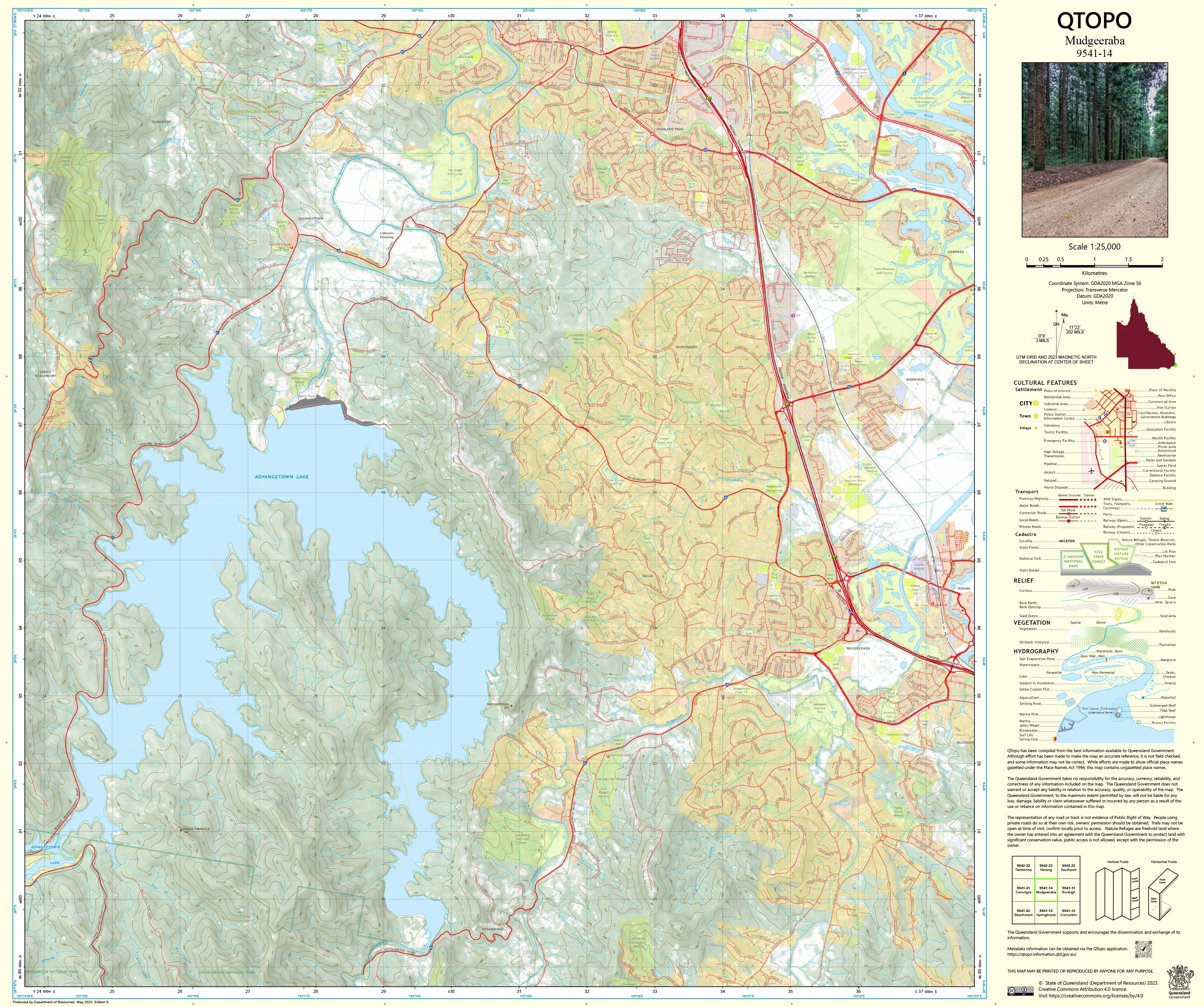
9541-14 Mudgeeraba QTopo 1:25,000 Topographic Map
QTopo 9541-14 — Mudgeeraba
1:25,000 Topographic Map
A detailed topographic map covering the Mudgeeraba region—an area where suburban growth, rural properties, creek corridors, and hinterland foothills converge on the southern Gold Coast. With its mix of residential neighbourhoods, forested ridges, winding access roads, reservoirs, and environmentally sensitive creek systems, this landscape demands precise mapping for planning, navigation, environmental assessment, and emergency operations.
The QTopo 9541-14 (Mudgeeraba) sheet—created by the Queensland Department of Resources—forms part of the state’s authoritative 1:25,000 mapping series. It provides high-resolution elevation contours, hydrology detail, vegetation structure, and infrastructure mapping across a region of diverse landforms and rapidly evolving land use.
Whether you're assessing development areas, conducting ecological surveys, navigating hinterland roads, or coordinating emergency response, QTopo 9541-14 delivers the clarity and accuracy required for confident decision-making.
🗺️ Map Content and Features
At 1:25,000 scale—with 1 cm representing 250 m on the ground—this map includes:
-
Contour lines depicting suburban hills, ridgelines, escarpments, gullies, and hinterland slopes
-
Hydrology features: Mudgeeraba Creek, wetlands, tributaries, dams, drainage lines, and riparian zones
-
Road & transport networks including the M1 Motorway, suburban streets, rural access routes, and local connector roads
-
Infrastructure such as reservoirs, powerlines, fencelines, schools, community facilities, parks, and service corridors
-
Vegetation mapping identifying forest, woodland, conservation areas, plantations, and cleared land
-
Land tenure boundaries: residential zones, conservation reserves, council-managed land, freehold rural property, and state-owned parcels
-
Named features including hills, creeks, neighbourhoods, localities, lookouts, and recreation sites
-
Points of interest for planners, surveyors, emergency services, ecologists, residents, and outdoor users
All QTopo maps are produced using Queensland’s authoritative spatial datasets to ensure consistency and accuracy.
🧭 Who Uses This Map?
The Mudgeeraba 9541-14 Topographic Map is widely used by:
-
Urban planners & surveyors – development planning, slope analysis, boundary assessment
-
Environmental scientists & ecologists – habitat studies, waterway monitoring, vegetation surveys
-
Emergency services & SES – flood modelling, bushfire response, incident mapping
-
Rangers & land managers – park oversight, trail maintenance, creek-management programs
-
Residents & recreational explorers – understanding terrain, exploring bushland reserves, navigating trails
-
Educators & students – geography, environmental science, and urban-landform studies
A versatile and essential mapping tool for both professional and general use.
💧 Field-Ready Options for Urban, Creek & Hinterland Terrain
Choose a finish suited to the varied conditions of the Mudgeeraba landscape.
✅ Waterproof & Tearproof Tyvek®
-
Printed on DuPont™ Tyvek®
-
Fully waterproof, tear-resistant, and robust
-
Ideal for creek studies, all-weather inspections, and rugged fieldwork
✅ Laminated Edition
-
Encapsulated in 2 × 80-micron gloss laminate
-
Writeable surface supports whiteboard markers
-
Resistant to moisture, dirt, oil, and repeated handling
📄 Standard Paper Edition
-
Crisp, high-quality printing
-
Perfect for planning, office use, and study
📐 Map Details
Title: QTopo 9541-14 — Mudgeeraba
Publisher: Queensland Department of Resources
Series: QTopo 1:25,000
Scale: 1:25,000 (1 cm = 250 m)
Dimensions: 710 mm (width) × 594 mm (height)
Coverage: Mudgeeraba township and hinterland, M1 corridor, creek systems, suburban hills, rural properties, parks, and bushland reserves
Material Options: Paper, laminated, or waterproof Tyvek®
Printed in: Australia
Edition: Latest available (see listing)
📥 QTopo Map Index
Need adjoining Gold Coast or hinterland sheets?
➡️ Provide nearby sheet numbers—such as 9541-13, 9541-21, or 9441-14—and I’ll identify the adjoining maps instantly.
🛒 Ordering & Options
-
Standard folded paper map – ideal for planning, reference, and study
-
Tyvek® waterproof edition – perfect for wet-weather inspections and rugged fieldwork
-
Laminated edition – reusable, durable, and ideal for operational or educational environments
-
Flat (unfolded) maps available for wall mounting or map-board display
🎯 Summary
The QTopo 9541-14 — Mudgeeraba Topographic Map provides detailed, authoritative mapping of terrain, hydrology, vegetation, infrastructure, and access across a complex and fast-growing Gold Coast region. With accurate 1:25,000 mapping and durable field-ready formats, it is indispensable for surveyors, ecologists, planners, emergency responders, and local residents.
Plan with purpose.
Navigate with confidence.
Explore with clarity.
Choose your preferred finish today and take the Mudgeeraba QTopo map into the field with Queensland’s most trusted topographic mapping.
Product Information
Product Information
Shipping & Returns
Shipping & Returns
Description
QTopo 9541-14 — Mudgeeraba
1:25,000 Topographic Map
A detailed topographic map covering the Mudgeeraba region—an area where suburban growth, rural properties, creek corridors, and hinterland foothills converge on the southern Gold Coast. With its mix of residential neighbourhoods, forested ridges, winding access roads, reservoirs, and environmentally sensitive creek systems, this landscape demands precise mapping for planning, navigation, environmental assessment, and emergency operations.
The QTopo 9541-14 (Mudgeeraba) sheet—created by the Queensland Department of Resources—forms part of the state’s authoritative 1:25,000 mapping series. It provides high-resolution elevation contours, hydrology detail, vegetation structure, and infrastructure mapping across a region of diverse landforms and rapidly evolving land use.
Whether you're assessing development areas, conducting ecological surveys, navigating hinterland roads, or coordinating emergency response, QTopo 9541-14 delivers the clarity and accuracy required for confident decision-making.
🗺️ Map Content and Features
At 1:25,000 scale—with 1 cm representing 250 m on the ground—this map includes:
-
Contour lines depicting suburban hills, ridgelines, escarpments, gullies, and hinterland slopes
-
Hydrology features: Mudgeeraba Creek, wetlands, tributaries, dams, drainage lines, and riparian zones
-
Road & transport networks including the M1 Motorway, suburban streets, rural access routes, and local connector roads
-
Infrastructure such as reservoirs, powerlines, fencelines, schools, community facilities, parks, and service corridors
-
Vegetation mapping identifying forest, woodland, conservation areas, plantations, and cleared land
-
Land tenure boundaries: residential zones, conservation reserves, council-managed land, freehold rural property, and state-owned parcels
-
Named features including hills, creeks, neighbourhoods, localities, lookouts, and recreation sites
-
Points of interest for planners, surveyors, emergency services, ecologists, residents, and outdoor users
All QTopo maps are produced using Queensland’s authoritative spatial datasets to ensure consistency and accuracy.
🧭 Who Uses This Map?
The Mudgeeraba 9541-14 Topographic Map is widely used by:
-
Urban planners & surveyors – development planning, slope analysis, boundary assessment
-
Environmental scientists & ecologists – habitat studies, waterway monitoring, vegetation surveys
-
Emergency services & SES – flood modelling, bushfire response, incident mapping
-
Rangers & land managers – park oversight, trail maintenance, creek-management programs
-
Residents & recreational explorers – understanding terrain, exploring bushland reserves, navigating trails
-
Educators & students – geography, environmental science, and urban-landform studies
A versatile and essential mapping tool for both professional and general use.
💧 Field-Ready Options for Urban, Creek & Hinterland Terrain
Choose a finish suited to the varied conditions of the Mudgeeraba landscape.
✅ Waterproof & Tearproof Tyvek®
-
Printed on DuPont™ Tyvek®
-
Fully waterproof, tear-resistant, and robust
-
Ideal for creek studies, all-weather inspections, and rugged fieldwork
✅ Laminated Edition
-
Encapsulated in 2 × 80-micron gloss laminate
-
Writeable surface supports whiteboard markers
-
Resistant to moisture, dirt, oil, and repeated handling
📄 Standard Paper Edition
-
Crisp, high-quality printing
-
Perfect for planning, office use, and study
📐 Map Details
Title: QTopo 9541-14 — Mudgeeraba
Publisher: Queensland Department of Resources
Series: QTopo 1:25,000
Scale: 1:25,000 (1 cm = 250 m)
Dimensions: 710 mm (width) × 594 mm (height)
Coverage: Mudgeeraba township and hinterland, M1 corridor, creek systems, suburban hills, rural properties, parks, and bushland reserves
Material Options: Paper, laminated, or waterproof Tyvek®
Printed in: Australia
Edition: Latest available (see listing)
📥 QTopo Map Index
Need adjoining Gold Coast or hinterland sheets?
➡️ Provide nearby sheet numbers—such as 9541-13, 9541-21, or 9441-14—and I’ll identify the adjoining maps instantly.
🛒 Ordering & Options
-
Standard folded paper map – ideal for planning, reference, and study
-
Tyvek® waterproof edition – perfect for wet-weather inspections and rugged fieldwork
-
Laminated edition – reusable, durable, and ideal for operational or educational environments
-
Flat (unfolded) maps available for wall mounting or map-board display
🎯 Summary
The QTopo 9541-14 — Mudgeeraba Topographic Map provides detailed, authoritative mapping of terrain, hydrology, vegetation, infrastructure, and access across a complex and fast-growing Gold Coast region. With accurate 1:25,000 mapping and durable field-ready formats, it is indispensable for surveyors, ecologists, planners, emergency responders, and local residents.
Plan with purpose.
Navigate with confidence.
Explore with clarity.
Choose your preferred finish today and take the Mudgeeraba QTopo map into the field with Queensland’s most trusted topographic mapping.


