9541-31 Tyalgum QTopo 1:25,000 Topographic Map
QTopo 9541-31 — Tyalgum
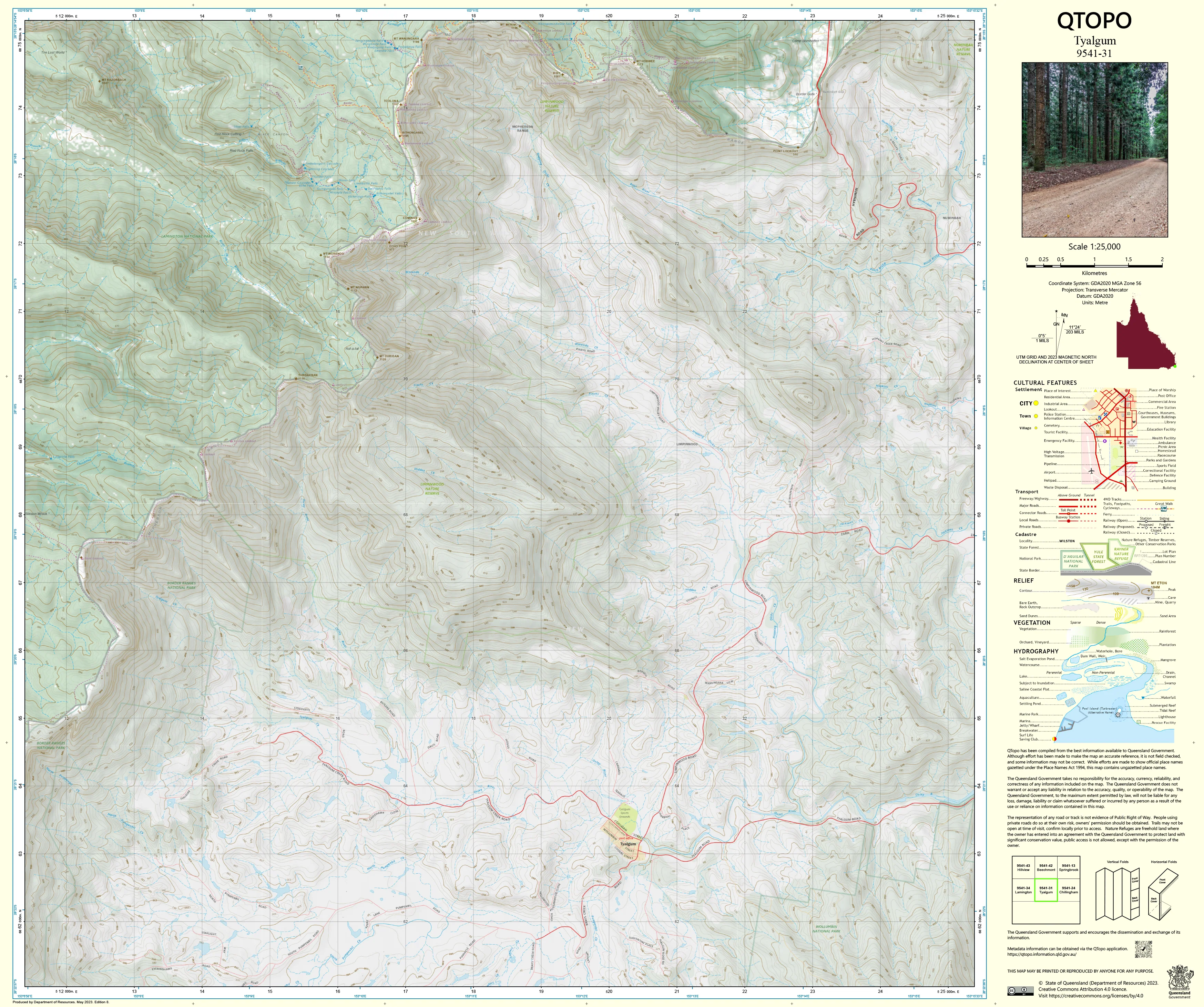
1:25,000 Topographic Map
A highly detailed topographic map covering the Tyalgum region—an area defined by dramatic escarpments, rainforest-clad slopes, steep volcanic terrain, remote creek valleys, and the rugged foothills of the Shield Volcano that forms the UNESCO-listed Tweed Caldera. With its mix of national park, conservation land, rural properties, and wilderness terrain, Tyalgum is a landscape where reliable mapping is essential for navigation, environmental science, land management, and emergency response.
The QTopo 9541-31 (Tyalgum) sheet—produced by the Queensland Department of Resources—is part of Queensland’s authoritative 1:25,000 topographic series. It provides precise elevation contours, hydrology networks, vegetation structure, and access detail across one of the most geologically and ecologically significant areas along the Queensland–New South Wales border.
Whether you're conducting ecological fieldwork, exploring escarpment trails, planning fire operations, or analysing complex terrain, QTopo 9541-31 delivers the clarity and accuracy necessary for working safely in steep, forested, and remote country.
🗺️ Map Content and Features
At 1:25,000 scale—where 1 cm on the map equals 250 m on the ground—this map includes:
-
Contour lines showing cliffs, ridgelines, plateaus, volcanic remnants, steep gullies, and high-elevation terrain
-
Hydrology features: Oxley River tributaries, mountain creeks, drainage lines, waterfalls, and upper-catchment water systems
-
Access tracks & routes including rural roads, ridge tracks, fire trails, and limited-access management routes
-
Infrastructure such as fencelines, powerlines, rural buildings, communication points, and boundary markers
-
Vegetation mapping identifying rainforest, wet sclerophyll forest, woodland, heath, and riparian vegetation
-
Land tenure boundaries: national park, conservation reserves, state-managed land, and freehold rural properties
-
Named natural features including peaks, lookout points, creek systems, ridges, saddles, and locality markers
-
Points of interest for ecologists, rangers, surveyors, emergency services, and experienced bushwalkers
All QTopo products are generated from Queensland’s authoritative spatial datasets for dependable accuracy.
🧭 Who Uses This Map?
The Tyalgum 9541-31 Topographic Map is commonly used by:
-
Environmental scientists & ecologists – habitat surveys, biodiversity studies, rainforest assessment
-
Surveyors & GIS practitioners – terrain modelling, boundary confirmation, slope analysis
-
Emergency services & SES – search & rescue, bushfire response, flood mapping
-
Rangers & land managers – conservation management, track maintenance, strategic planning
-
Advanced bushwalkers & explorers – navigating remote, steep, and densely vegetated terrain
-
Outdoor educators & students – studying volcanic landforms, ecology, and highland navigation
A critical resource for both professional and experienced recreational field users.
💧 Field-Ready Options for Rainforest, Escarpment & Mountain Terrain
Choose a finish designed for the tough conditions typical of the Tyalgum region.
✅ Waterproof & Tearproof Tyvek®
-
Printed on DuPont™ Tyvek®
-
Fully waterproof, tough, and tear-resistant
-
Ideal for wet-weather fieldwork, creek crossings, and rugged mountain environments
✅ Laminated Edition
-
Encapsulated in 2 × 80-micron gloss laminate
-
Writeable surface suitable for whiteboard markers
-
Resistant to rain, mud, mist, and repeated handling
📄 Standard Paper Edition
-
Crisp, high-resolution print
-
Best for office planning, research, and map study
📐 Map Details
Title: QTopo 9541-31 — Tyalgum
Publisher: Queensland Department of Resources
Series: QTopo 1:25,000
Scale: 1:25,000 (1 cm = 250 m)
Dimensions: 710 mm (width) × 594 mm (height)
Coverage: Tyalgum surrounds, escarpments, rainforest, creek systems, ridge networks, national park land, and remote hinterland terrain
Material Options: Paper, laminated, or waterproof Tyvek®
Printed in: Australia
Edition: Latest available (see listing)
📥 QTopo Map Index
Need adjoining border or hinterland sheets?
➡️ Provide nearby sheet numbers—such as 9541-21, 9541-32, or 9441-31—and I’ll identify adjoining maps instantly.
🛒 Ordering & Options
-
Standard folded paper map – ideal for planning, research, and office reference
-
Tyvek® waterproof edition – perfect for rugged rainforest terrain, steep escarpments, and all-weather fieldwork
-
Laminated edition – durable, reusable, and suitable for operational and educational use
-
Flat (unfolded) maps available for wall display or terrain analysis boards
🎯 Summary
The QTopo 9541-31 — Tyalgum Topographic Map provides essential detail on terrain, hydrology, vegetation, access, and land classification across a spectacular volcanic and rainforest landscape. With precise 1:25,000 mapping and robust print options, it is indispensable for ecologists, surveyors, rangers, emergency crews, and serious bushwalkers.
Plan with purpose.
Navigate with confidence.
Explore with clarity.
Choose your preferred finish today and take the Tyalgum QTopo map into the field with Queensland’s most trusted topographic mapping.
Original: $14.27
-65%$14.27
$4.99Product Information
Product Information
Shipping & Returns
Shipping & Returns
Description
QTopo 9541-31 — Tyalgum
1:25,000 Topographic Map
A highly detailed topographic map covering the Tyalgum region—an area defined by dramatic escarpments, rainforest-clad slopes, steep volcanic terrain, remote creek valleys, and the rugged foothills of the Shield Volcano that forms the UNESCO-listed Tweed Caldera. With its mix of national park, conservation land, rural properties, and wilderness terrain, Tyalgum is a landscape where reliable mapping is essential for navigation, environmental science, land management, and emergency response.
The QTopo 9541-31 (Tyalgum) sheet—produced by the Queensland Department of Resources—is part of Queensland’s authoritative 1:25,000 topographic series. It provides precise elevation contours, hydrology networks, vegetation structure, and access detail across one of the most geologically and ecologically significant areas along the Queensland–New South Wales border.
Whether you're conducting ecological fieldwork, exploring escarpment trails, planning fire operations, or analysing complex terrain, QTopo 9541-31 delivers the clarity and accuracy necessary for working safely in steep, forested, and remote country.
🗺️ Map Content and Features
At 1:25,000 scale—where 1 cm on the map equals 250 m on the ground—this map includes:
-
Contour lines showing cliffs, ridgelines, plateaus, volcanic remnants, steep gullies, and high-elevation terrain
-
Hydrology features: Oxley River tributaries, mountain creeks, drainage lines, waterfalls, and upper-catchment water systems
-
Access tracks & routes including rural roads, ridge tracks, fire trails, and limited-access management routes
-
Infrastructure such as fencelines, powerlines, rural buildings, communication points, and boundary markers
-
Vegetation mapping identifying rainforest, wet sclerophyll forest, woodland, heath, and riparian vegetation
-
Land tenure boundaries: national park, conservation reserves, state-managed land, and freehold rural properties
-
Named natural features including peaks, lookout points, creek systems, ridges, saddles, and locality markers
-
Points of interest for ecologists, rangers, surveyors, emergency services, and experienced bushwalkers
All QTopo products are generated from Queensland’s authoritative spatial datasets for dependable accuracy.
🧭 Who Uses This Map?
The Tyalgum 9541-31 Topographic Map is commonly used by:
-
Environmental scientists & ecologists – habitat surveys, biodiversity studies, rainforest assessment
-
Surveyors & GIS practitioners – terrain modelling, boundary confirmation, slope analysis
-
Emergency services & SES – search & rescue, bushfire response, flood mapping
-
Rangers & land managers – conservation management, track maintenance, strategic planning
-
Advanced bushwalkers & explorers – navigating remote, steep, and densely vegetated terrain
-
Outdoor educators & students – studying volcanic landforms, ecology, and highland navigation
A critical resource for both professional and experienced recreational field users.
💧 Field-Ready Options for Rainforest, Escarpment & Mountain Terrain
Choose a finish designed for the tough conditions typical of the Tyalgum region.
✅ Waterproof & Tearproof Tyvek®
-
Printed on DuPont™ Tyvek®
-
Fully waterproof, tough, and tear-resistant
-
Ideal for wet-weather fieldwork, creek crossings, and rugged mountain environments
✅ Laminated Edition
-
Encapsulated in 2 × 80-micron gloss laminate
-
Writeable surface suitable for whiteboard markers
-
Resistant to rain, mud, mist, and repeated handling
📄 Standard Paper Edition
-
Crisp, high-resolution print
-
Best for office planning, research, and map study
📐 Map Details
Title: QTopo 9541-31 — Tyalgum
Publisher: Queensland Department of Resources
Series: QTopo 1:25,000
Scale: 1:25,000 (1 cm = 250 m)
Dimensions: 710 mm (width) × 594 mm (height)
Coverage: Tyalgum surrounds, escarpments, rainforest, creek systems, ridge networks, national park land, and remote hinterland terrain
Material Options: Paper, laminated, or waterproof Tyvek®
Printed in: Australia
Edition: Latest available (see listing)
📥 QTopo Map Index
Need adjoining border or hinterland sheets?
➡️ Provide nearby sheet numbers—such as 9541-21, 9541-32, or 9441-31—and I’ll identify adjoining maps instantly.
🛒 Ordering & Options
-
Standard folded paper map – ideal for planning, research, and office reference
-
Tyvek® waterproof edition – perfect for rugged rainforest terrain, steep escarpments, and all-weather fieldwork
-
Laminated edition – durable, reusable, and suitable for operational and educational use
-
Flat (unfolded) maps available for wall display or terrain analysis boards
🎯 Summary
The QTopo 9541-31 — Tyalgum Topographic Map provides essential detail on terrain, hydrology, vegetation, access, and land classification across a spectacular volcanic and rainforest landscape. With precise 1:25,000 mapping and robust print options, it is indispensable for ecologists, surveyors, rangers, emergency crews, and serious bushwalkers.
Plan with purpose.
Navigate with confidence.
Explore with clarity.
Choose your preferred finish today and take the Tyalgum QTopo map into the field with Queensland’s most trusted topographic mapping.


