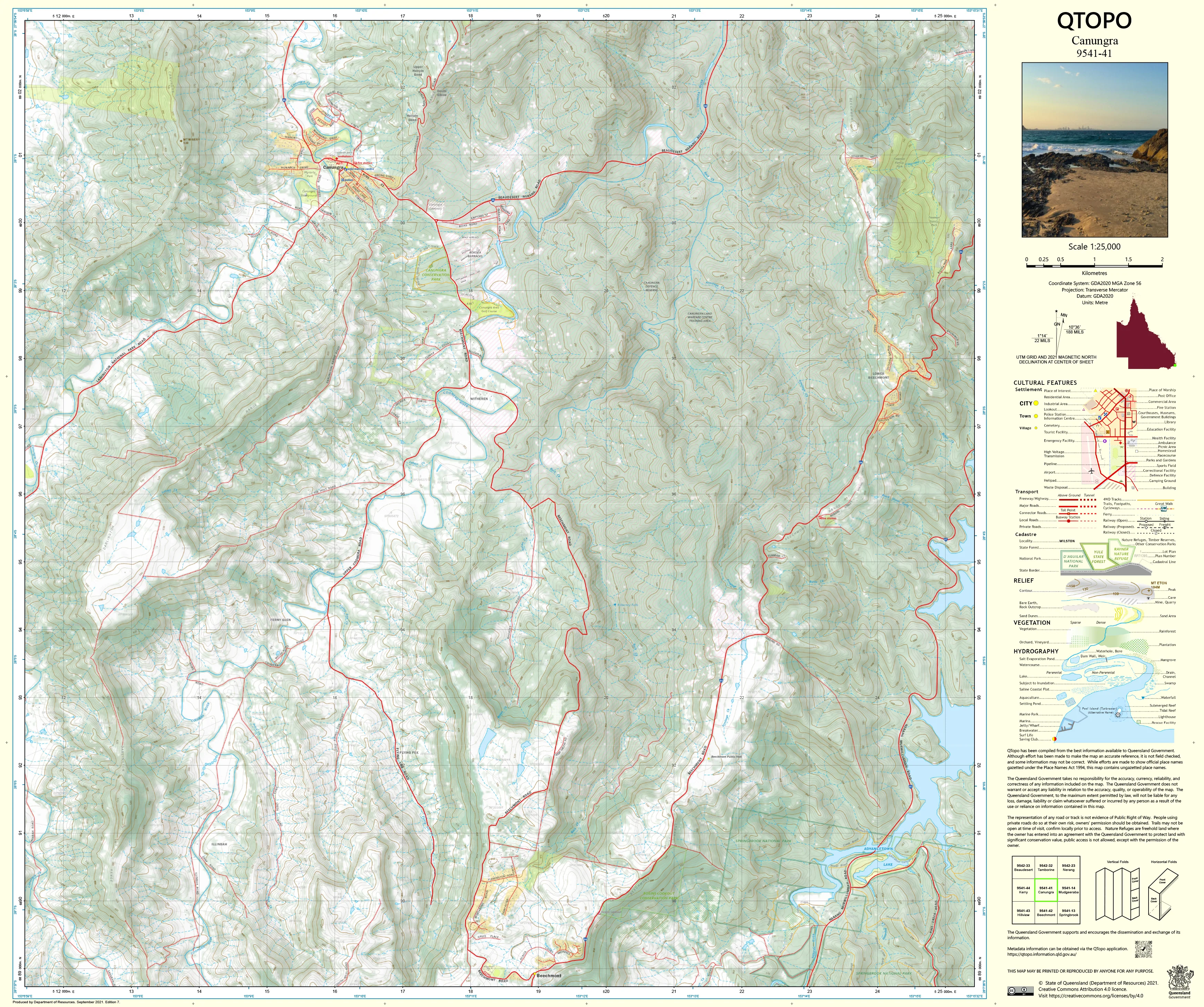
9541-41 Canungra QTopo 1:25,000 Topographic Map
QTopo 9541-41 — Canungra
1:25,000 Topographic Map
A highly detailed topographic map covering the Canungra region—one of the Scenic Rim’s most diverse landscapes, where rural valleys, vineyards, military training areas, forested hills, and rugged hinterland terrain converge. With its mix of agricultural land, Defence training zones, creek systems, steep ridgelines, and expanding rural–residential areas, Canungra is a region where precise mapping is essential for navigation, land management, planning, and emergency response.
The QTopo 9541-41 (Canungra) sheet—produced by the Queensland Department of Resources—is part of the authoritative 1:25,000 state topographic mapping series. It offers accurate elevation contours, hydrology detail, vegetation structure, infrastructure mapping, and access routes across a landscape known for its scenic drives, training facilities, vineyards, and gateway position to Lamington National Park.
Whether you're coordinating field operations, conducting environmental assessments, navigating rural roads, or exploring the hinterland, QTopo 9541-41 provides the clarity, reliability, and precision crucial for confident decision-making.
🗺️ Map Content and Features
At 1:25,000 scale—where 1 cm represents 250 m—this map includes:
-
Contour lines showing valleys, slopes, ridgelines, escarpments, and rolling agricultural country
-
Hydrology features: Canungra Creek, tributaries, drainage lines, farm dams, and riparian corridors
-
Road networks & access routes including Beaudesert–Nerang Road, rural connectors, 4WD tracks, and internal Defence access roads
-
Infrastructure such as Kokoda Barracks facilities, fencelines, powerlines, vineyards, rural buildings, and recreation sites
-
Vegetation mapping identifying state forest, woodland, rainforest pockets, cleared farmland, and restored habitat areas
-
Land tenure boundaries: freehold rural properties, Defence land, conservation zones, state forest, and council-managed areas
-
Named natural and locality features including hills, creek systems, ridges, viewpoints, training zones, and scenic lookouts
-
Points of interest for surveyors, Defence personnel, ecologists, emergency services, and hinterland explorers
All QTopo maps use Queensland’s authoritative spatial datasets for dependable, consistent accuracy.
🧭 Who Uses This Map?
The Canungra 9541-41 Topographic Map is widely relied upon by:
-
Environmental scientists & ecologists – habitat surveys, species monitoring, catchment analysis
-
Surveyors & land planners – development assessment, terrain modelling, boundary interpretation
-
Emergency services & SES – flood modelling, bushfire response, search & rescue
-
Defence personnel – navigation, terrain study, training coordination
-
Rural landholders & farmers – infrastructure planning, water management, land-use decisions
-
Hikers, cyclists & outdoor enthusiasts – exploring hinterland roads, forest areas, and scenic viewpoints
-
Educators & students – studying topography, hydrology, and regional geography
A versatile and essential resource for both professional and high-level recreational use.
💧 Field-Ready Options for Rural, Forest & Defence Terrain
Choose a finish suited to the varied conditions of the Canungra district.
✅ Waterproof & Tearproof Tyvek®
-
Printed on DuPont™ Tyvek®
-
Fully waterproof, tear-resistant, and durable
-
Ideal for rugged fieldwork, all-weather inspections, and Defence training environments
✅ Laminated Edition
-
Encapsulated in 2 × 80-micron gloss laminate
-
Writeable surface compatible with whiteboard markers
-
Resistant to moisture, mud, dust, and repeated handling
📄 Standard Paper Edition
-
High-resolution printing
-
Suitable for office planning, study, and occasional field reference
📐 Map Details
Title: QTopo 9541-41 — Canungra
Publisher: Queensland Department of Resources
Series: QTopo 1:25,000
Scale: 1:25,000 (1 cm = 250 m)
Dimensions: 710 mm (width) × 594 mm (height)
Coverage: Canungra township, Kokoda Barracks, surrounding rural land, forest, creek systems, hinterland slopes, and access routes
Material Options: Paper, laminated, or waterproof Tyvek®
Printed in: Australia
Edition: Latest available (see listing)
📥 QTopo Map Index
Need adjoining Scenic Rim or Gold Coast hinterland sheets?
➡️ Provide nearby sheet numbers—such as 9541-34, 9541-42, or 9441-41—and I’ll identify all adjoining maps instantly.
🛒 Ordering & Options
-
Standard folded paper map – excellent for planning and reference
-
Tyvek® waterproof edition – perfect for rugged, high-use field environments
-
Laminated edition – durable, reusable, and ideal for operational or training applications
-
Flat (unfolded) maps available for wall display or terrain analysis boards
🎯 Summary
The QTopo 9541-41 — Canungra Topographic Map provides essential detail on terrain, hydrology, vegetation, access, and land classification across one of the Scenic Rim’s most varied and strategically important regions. With authoritative 1:25,000 mapping and tough field-ready formats, it is indispensable for Defence teams, ecologists, surveyors, emergency crews, land managers, and outdoor explorers.
Plan with purpose.
Navigate with confidence.
Explore with clarity.
Choose your preferred finish today and take the Canungra QTopo map into the field with Queensland’s most trusted topographic mapping.
Original: $14.27
-65%$14.27
$4.99Product Information
Product Information
Shipping & Returns
Shipping & Returns
Description
QTopo 9541-41 — Canungra
1:25,000 Topographic Map
A highly detailed topographic map covering the Canungra region—one of the Scenic Rim’s most diverse landscapes, where rural valleys, vineyards, military training areas, forested hills, and rugged hinterland terrain converge. With its mix of agricultural land, Defence training zones, creek systems, steep ridgelines, and expanding rural–residential areas, Canungra is a region where precise mapping is essential for navigation, land management, planning, and emergency response.
The QTopo 9541-41 (Canungra) sheet—produced by the Queensland Department of Resources—is part of the authoritative 1:25,000 state topographic mapping series. It offers accurate elevation contours, hydrology detail, vegetation structure, infrastructure mapping, and access routes across a landscape known for its scenic drives, training facilities, vineyards, and gateway position to Lamington National Park.
Whether you're coordinating field operations, conducting environmental assessments, navigating rural roads, or exploring the hinterland, QTopo 9541-41 provides the clarity, reliability, and precision crucial for confident decision-making.
🗺️ Map Content and Features
At 1:25,000 scale—where 1 cm represents 250 m—this map includes:
-
Contour lines showing valleys, slopes, ridgelines, escarpments, and rolling agricultural country
-
Hydrology features: Canungra Creek, tributaries, drainage lines, farm dams, and riparian corridors
-
Road networks & access routes including Beaudesert–Nerang Road, rural connectors, 4WD tracks, and internal Defence access roads
-
Infrastructure such as Kokoda Barracks facilities, fencelines, powerlines, vineyards, rural buildings, and recreation sites
-
Vegetation mapping identifying state forest, woodland, rainforest pockets, cleared farmland, and restored habitat areas
-
Land tenure boundaries: freehold rural properties, Defence land, conservation zones, state forest, and council-managed areas
-
Named natural and locality features including hills, creek systems, ridges, viewpoints, training zones, and scenic lookouts
-
Points of interest for surveyors, Defence personnel, ecologists, emergency services, and hinterland explorers
All QTopo maps use Queensland’s authoritative spatial datasets for dependable, consistent accuracy.
🧭 Who Uses This Map?
The Canungra 9541-41 Topographic Map is widely relied upon by:
-
Environmental scientists & ecologists – habitat surveys, species monitoring, catchment analysis
-
Surveyors & land planners – development assessment, terrain modelling, boundary interpretation
-
Emergency services & SES – flood modelling, bushfire response, search & rescue
-
Defence personnel – navigation, terrain study, training coordination
-
Rural landholders & farmers – infrastructure planning, water management, land-use decisions
-
Hikers, cyclists & outdoor enthusiasts – exploring hinterland roads, forest areas, and scenic viewpoints
-
Educators & students – studying topography, hydrology, and regional geography
A versatile and essential resource for both professional and high-level recreational use.
💧 Field-Ready Options for Rural, Forest & Defence Terrain
Choose a finish suited to the varied conditions of the Canungra district.
✅ Waterproof & Tearproof Tyvek®
-
Printed on DuPont™ Tyvek®
-
Fully waterproof, tear-resistant, and durable
-
Ideal for rugged fieldwork, all-weather inspections, and Defence training environments
✅ Laminated Edition
-
Encapsulated in 2 × 80-micron gloss laminate
-
Writeable surface compatible with whiteboard markers
-
Resistant to moisture, mud, dust, and repeated handling
📄 Standard Paper Edition
-
High-resolution printing
-
Suitable for office planning, study, and occasional field reference
📐 Map Details
Title: QTopo 9541-41 — Canungra
Publisher: Queensland Department of Resources
Series: QTopo 1:25,000
Scale: 1:25,000 (1 cm = 250 m)
Dimensions: 710 mm (width) × 594 mm (height)
Coverage: Canungra township, Kokoda Barracks, surrounding rural land, forest, creek systems, hinterland slopes, and access routes
Material Options: Paper, laminated, or waterproof Tyvek®
Printed in: Australia
Edition: Latest available (see listing)
📥 QTopo Map Index
Need adjoining Scenic Rim or Gold Coast hinterland sheets?
➡️ Provide nearby sheet numbers—such as 9541-34, 9541-42, or 9441-41—and I’ll identify all adjoining maps instantly.
🛒 Ordering & Options
-
Standard folded paper map – excellent for planning and reference
-
Tyvek® waterproof edition – perfect for rugged, high-use field environments
-
Laminated edition – durable, reusable, and ideal for operational or training applications
-
Flat (unfolded) maps available for wall display or terrain analysis boards
🎯 Summary
The QTopo 9541-41 — Canungra Topographic Map provides essential detail on terrain, hydrology, vegetation, access, and land classification across one of the Scenic Rim’s most varied and strategically important regions. With authoritative 1:25,000 mapping and tough field-ready formats, it is indispensable for Defence teams, ecologists, surveyors, emergency crews, land managers, and outdoor explorers.
Plan with purpose.
Navigate with confidence.
Explore with clarity.
Choose your preferred finish today and take the Canungra QTopo map into the field with Queensland’s most trusted topographic mapping.


