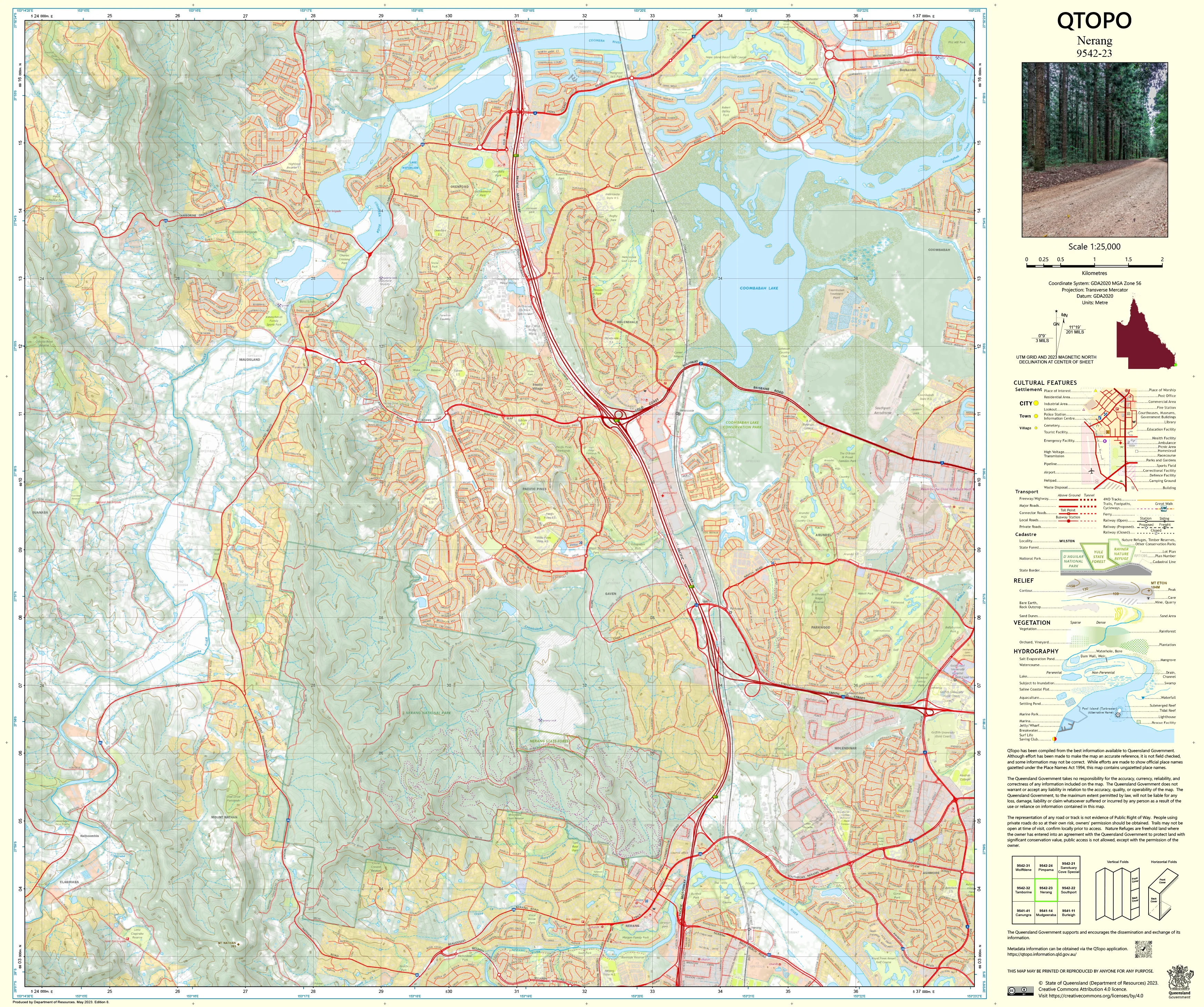
9542-23 Nerang QTopo 1:25,000 Topographic Map
QTopo 9542-23 — Nerang
1:25,000 Topographic Map
A highly detailed topographic map covering the Nerang region—one of the central hubs of the Gold Coast hinterland. With its blend of urban development, waterways, forested reserves, steep hinterland slopes, rural properties, and major transport corridors, Nerang is a complex and fast-changing landscape where precise mapping is essential for planning, navigation, environmental monitoring, and emergency response.
The QTopo 9542-23 (Nerang) sheet—produced by the Queensland Department of Resources—forms part of the official 1:25,000 topographic mapping series. It provides high-resolution elevation contours, hydrology networks, vegetation mapping, infrastructure detail, and access routes across an area that links the coastal plain with the foothills of the Scenic Rim and the upper Nerang River catchment.
Whether you're assessing development constraints, coordinating emergency operations, studying creek systems, or navigating hinterland roads and reserves, QTopo 9542-23 delivers the accurate, reliable detail required for confident decision-making.
🗺️ Map Content and Features
At 1:25,000 scale, where 1 cm equals 250 m, this map includes:
-
Contour lines showing steep hills, ridgelines, escarpments, valleys, and the transition from coastal terrain to hinterland foothills
-
Hydrology features: Nerang River, Hinze Dam catchment, tributaries, wetlands, floodplains, and drainage lines
-
Road & transport networks including the M1 Motorway, Nerang–Murwillumbah Road, suburban connectors, and rural access roads
-
Infrastructure such as powerlines, reservoirs, fencelines, water facilities, schools, parks, and urban precincts
-
Vegetation mapping indicating conservation areas, state forest, woodland, urban green spaces, and cleared residential land
-
Land tenure boundaries: national park, council-managed reserves, water catchment land, and freehold parcels
-
Named features including Nerang township, hills, creek systems, localities, recreation areas, and trail access points
-
Points of interest for planners, surveyors, ecologists, emergency teams, urban developers, and recreational users
All QTopo maps are built from Queensland’s authoritative spatial datasets for dependable and consistent detail.
🧭 Who Uses This Map?
The Nerang 9542-23 Topographic Map is commonly used by:
-
Surveyors & land-use planners – zoning analysis, contour modelling, flood-risk assessment
-
Environmental scientists & ecologists – catchment studies, habitat monitoring, vegetation surveys
-
Emergency services & SES – operational planning, flood modelling, bushfire response
-
Urban developers & civil engineers – terrain analysis, infrastructure planning, drainage design
-
Hikers, cyclists & outdoor explorers – navigating reserves, ridgelines, and hinterland routes
-
Residents & landholders – property understanding and land-management planning
-
Educators & students – regional geography, hydrology, and environmental science
A vital resource for both professional and advanced recreational navigation.
💧 Field-Ready Options for Urban, Riverine & Hinterland Terrain
Choose a finish designed to withstand Nerang’s varied conditions.
✅ Waterproof & Tearproof Tyvek®
-
Printed on DuPont™ Tyvek®
-
Completely waterproof, resilient, and tear-resistant
-
Ideal for river work, catchment studies, and all-weather inspections
✅ Laminated Edition
-
Encapsulated in 2 × 80-micron gloss laminate
-
Features a writeable surface compatible with dry-erase markers
-
Resistant to moisture, dirt, mud, and frequent handling
📄 Standard Paper Edition
-
High-resolution, crisp printing
-
Best for office work, planning, and teaching
📐 Map Details
Title: QTopo 9542-23 — Nerang
Publisher: Queensland Department of Resources
Series: QTopo 1:25,000
Scale: 1:25,000 (1 cm = 250 m)
Dimensions: 710 mm (width) × 594 mm (height)
Coverage: Nerang township, M1 corridor, Nerang River system, Hinze Dam catchment, foothills, reserves, corridors, and surrounding hinterland
Material Options: Paper, laminated, or waterproof Tyvek®
Printed in: Australia
Edition: Latest available (see listing)
📥 QTopo Map Index
Need adjoining Gold Coast or hinterland sheets?
➡️ Provide nearby sheet numbers—such as 9542-13, 9541-42, or 9442-23—and I’ll identify all adjoining maps instantly.
🛒 Ordering & Options
-
Standard folded paper map – perfect for planning, reference, and analysis
-
Tyvek® waterproof edition – ideal for rugged fieldwork and waterway studies
-
Laminated edition – reusable, durable, and suitable for operational tasks
-
Flat (unfolded) maps available for wall display or survey boards
🎯 Summary
The QTopo 9542-23 — Nerang Topographic Map provides essential detail on terrain, hydrology, access networks, land classification, and development patterns across a region linking the Gold Coast’s urban core with its hinterland. With authoritative 1:25,000 mapping and robust field-ready print options, it is indispensable for surveyors, ecologists, emergency crews, planners, and outdoor explorers.
Plan with purpose.
Navigate with confidence.
Explore with clarity.
Choose your preferred finish today and take the Nerang QTopo map into the field with Queensland’s most trusted topographic mapping.
Original: $14.27
-65%$14.27
$4.99Product Information
Product Information
Shipping & Returns
Shipping & Returns
Description
QTopo 9542-23 — Nerang
1:25,000 Topographic Map
A highly detailed topographic map covering the Nerang region—one of the central hubs of the Gold Coast hinterland. With its blend of urban development, waterways, forested reserves, steep hinterland slopes, rural properties, and major transport corridors, Nerang is a complex and fast-changing landscape where precise mapping is essential for planning, navigation, environmental monitoring, and emergency response.
The QTopo 9542-23 (Nerang) sheet—produced by the Queensland Department of Resources—forms part of the official 1:25,000 topographic mapping series. It provides high-resolution elevation contours, hydrology networks, vegetation mapping, infrastructure detail, and access routes across an area that links the coastal plain with the foothills of the Scenic Rim and the upper Nerang River catchment.
Whether you're assessing development constraints, coordinating emergency operations, studying creek systems, or navigating hinterland roads and reserves, QTopo 9542-23 delivers the accurate, reliable detail required for confident decision-making.
🗺️ Map Content and Features
At 1:25,000 scale, where 1 cm equals 250 m, this map includes:
-
Contour lines showing steep hills, ridgelines, escarpments, valleys, and the transition from coastal terrain to hinterland foothills
-
Hydrology features: Nerang River, Hinze Dam catchment, tributaries, wetlands, floodplains, and drainage lines
-
Road & transport networks including the M1 Motorway, Nerang–Murwillumbah Road, suburban connectors, and rural access roads
-
Infrastructure such as powerlines, reservoirs, fencelines, water facilities, schools, parks, and urban precincts
-
Vegetation mapping indicating conservation areas, state forest, woodland, urban green spaces, and cleared residential land
-
Land tenure boundaries: national park, council-managed reserves, water catchment land, and freehold parcels
-
Named features including Nerang township, hills, creek systems, localities, recreation areas, and trail access points
-
Points of interest for planners, surveyors, ecologists, emergency teams, urban developers, and recreational users
All QTopo maps are built from Queensland’s authoritative spatial datasets for dependable and consistent detail.
🧭 Who Uses This Map?
The Nerang 9542-23 Topographic Map is commonly used by:
-
Surveyors & land-use planners – zoning analysis, contour modelling, flood-risk assessment
-
Environmental scientists & ecologists – catchment studies, habitat monitoring, vegetation surveys
-
Emergency services & SES – operational planning, flood modelling, bushfire response
-
Urban developers & civil engineers – terrain analysis, infrastructure planning, drainage design
-
Hikers, cyclists & outdoor explorers – navigating reserves, ridgelines, and hinterland routes
-
Residents & landholders – property understanding and land-management planning
-
Educators & students – regional geography, hydrology, and environmental science
A vital resource for both professional and advanced recreational navigation.
💧 Field-Ready Options for Urban, Riverine & Hinterland Terrain
Choose a finish designed to withstand Nerang’s varied conditions.
✅ Waterproof & Tearproof Tyvek®
-
Printed on DuPont™ Tyvek®
-
Completely waterproof, resilient, and tear-resistant
-
Ideal for river work, catchment studies, and all-weather inspections
✅ Laminated Edition
-
Encapsulated in 2 × 80-micron gloss laminate
-
Features a writeable surface compatible with dry-erase markers
-
Resistant to moisture, dirt, mud, and frequent handling
📄 Standard Paper Edition
-
High-resolution, crisp printing
-
Best for office work, planning, and teaching
📐 Map Details
Title: QTopo 9542-23 — Nerang
Publisher: Queensland Department of Resources
Series: QTopo 1:25,000
Scale: 1:25,000 (1 cm = 250 m)
Dimensions: 710 mm (width) × 594 mm (height)
Coverage: Nerang township, M1 corridor, Nerang River system, Hinze Dam catchment, foothills, reserves, corridors, and surrounding hinterland
Material Options: Paper, laminated, or waterproof Tyvek®
Printed in: Australia
Edition: Latest available (see listing)
📥 QTopo Map Index
Need adjoining Gold Coast or hinterland sheets?
➡️ Provide nearby sheet numbers—such as 9542-13, 9541-42, or 9442-23—and I’ll identify all adjoining maps instantly.
🛒 Ordering & Options
-
Standard folded paper map – perfect for planning, reference, and analysis
-
Tyvek® waterproof edition – ideal for rugged fieldwork and waterway studies
-
Laminated edition – reusable, durable, and suitable for operational tasks
-
Flat (unfolded) maps available for wall display or survey boards
🎯 Summary
The QTopo 9542-23 — Nerang Topographic Map provides essential detail on terrain, hydrology, access networks, land classification, and development patterns across a region linking the Gold Coast’s urban core with its hinterland. With authoritative 1:25,000 mapping and robust field-ready print options, it is indispensable for surveyors, ecologists, emergency crews, planners, and outdoor explorers.
Plan with purpose.
Navigate with confidence.
Explore with clarity.
Choose your preferred finish today and take the Nerang QTopo map into the field with Queensland’s most trusted topographic mapping.


