9542-42 Beenleigh QTopo 1:25,000 Topographic Map
QTopo 9542-42 — Beenleigh
1:25,000 Topographic Map
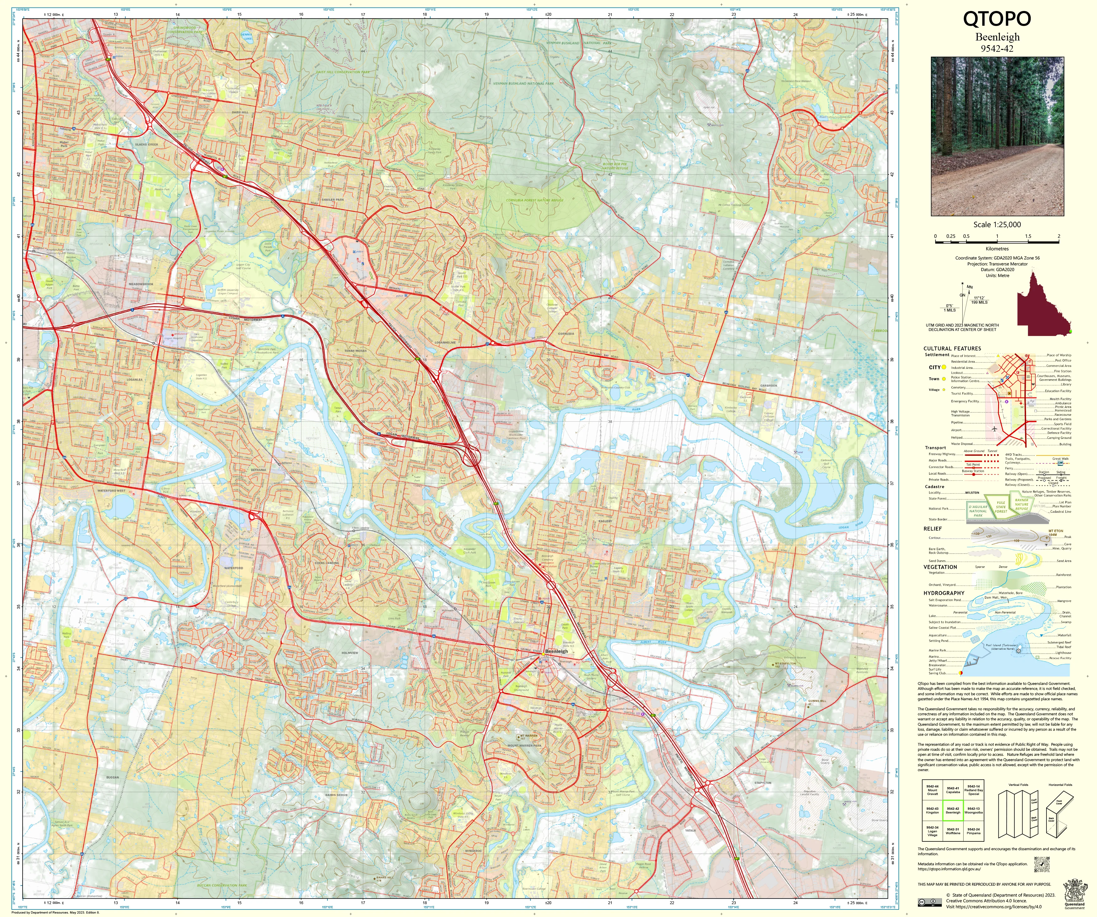
A detailed and authoritative topographic map covering Beenleigh, a key urban and industrial hub strategically positioned between Brisbane and the Gold Coast. With its mix of densely built suburbs, major transport corridors, river systems, wetlands, commercial precincts, and peri-urban fringe, Beenleigh is a region where accurate mapping is essential for planning, infrastructure development, emergency response, and environmental assessment.
The QTopo 9542-42 (Beenleigh) sheet—produced by the Queensland Department of Resources—is part of the state’s official 1:25,000 topographic mapping series. It offers precise elevation contours, hydrology detail, road and rail networks, vegetation structure, and land-use boundaries across one of Southeast Queensland’s busiest and most interconnected regions.
Whether you're modelling flood behaviour, managing transport projects, conducting urban planning, or navigating the Logan River and surrounding suburbs, QTopo 9542-42 delivers the clarity and accuracy needed for informed decision-making.
🗺️ Map Content and Features
At 1:25,000 scale—where 1 cm represents 250 m—this map includes:
-
Contour lines showing low-lying floodplains, ridgelines, elevated suburbs, and local hills
-
Hydrology features: Logan River, Albert River, Scrubby Creek, wetlands, drainage channels, and flood-prone areas
-
Transport networks including the M1 Motorway, Beenleigh–Redland Bay Road, suburban streets, the Gold Coast rail line, and pedestrian/cycle routes
-
Infrastructure such as powerlines, industrial areas, schools, parks, wastewater facilities, commercial precincts, and community services
-
Vegetation & land cover mapping conservation reserves, riparian corridors, parklands, bushland pockets, and developed land
-
Land tenure boundaries: freehold parcels, council-owned land, state-managed areas, easements, and utility corridors
-
Named features including Beenleigh town centre, Logan River crossings, rail stations, suburbs, sports precincts, and locality markers
-
Points of interest for planners, engineers, environmental scientists, emergency responders, and local communities
All QTopo maps are produced using Queensland’s authoritative spatial datasets for dependable accuracy.
🧭 Who Uses This Map?
The Beenleigh 9542-42 Topographic Map is widely used by:
-
Urban planners & surveyors – zoning, drainage analysis, redevelopment planning
-
Environmental scientists & ecologists – riparian monitoring, wetland assessments, habitat studies
-
Emergency services & SES – flood modelling, storm response, evacuation planning
-
Civil engineers & infrastructure teams – road design, transport planning, landform evaluation
-
Residents & landholders – understanding local terrain and waterways
-
Industry & commercial operators – logistics planning, site analysis
-
Educators & students – geography, hydrology, and urban-environment studies
A highly valuable resource for both technical and community-level use.
💧 Field-Ready Options for Urban, Riverine & Industrial Environments
Choose a finish suitable for the varied conditions around Beenleigh.
✅ Waterproof & Tearproof Tyvek®
-
Printed on DuPont™ Tyvek®
-
Fully waterproof, durable, and tear-resistant
-
Ideal for floodplain investigations, wetland work, and all-weather inspections
✅ Laminated Edition
-
Encapsulated in 2 × 80-micron gloss laminate
-
Writeable surface suitable for whiteboard markers
-
Resistant to water, mud, oils, and frequent handling
📄 Standard Paper Edition
-
Crisp and high-resolution
-
Suitable for planning, office reference, and education
📐 Map Details
Title: QTopo 9542-42 — Beenleigh
Publisher: Queensland Department of Resources
Series: QTopo 1:25,000
Scale: 1:25,000 (1 cm = 250 m)
Dimensions: 710 mm (width) × 594 mm (height)
Coverage: Beenleigh township, Logan River corridor, Albert River, suburbs, wetlands, industrial zones, and major transport networks
Material Options: Paper, laminated, or waterproof Tyvek®
Printed in: Australia
Edition: Latest available (see listing)
📥 QTopo Map Index
Need adjoining Brisbane South, Logan City, or Gold Coast region maps?
➡️ Provide nearby sheet numbers—such as 9542-33, 9542-31, or 9442-42—and I’ll identify all adjoining sheets instantly.
🛒 Ordering & Options
-
Standard folded paper map – ideal for planning and reference
-
Tyvek® waterproof edition – perfect for riverine and field-inspection work
-
Laminated edition – durable, reusable, and ideal for operational environments
-
Flat (unfolded) maps available for wall display or analysis boards
🎯 Summary
The QTopo 9542-42 — Beenleigh Topographic Map provides critical detail on hydrology, terrain, transport networks, land use, and infrastructure across one of Southeast Queensland’s busiest urban–river interface zones. With authoritative 1:25,000 mapping and rugged print options, it is indispensable for planners, ecologists, engineers, emergency responders, and local residents.
Plan with purpose.
Navigate with confidence.
Explore with clarity.
Choose your preferred finish today and take the Beenleigh QTopo map into the field with Queensland’s most trusted topographic mapping.
Original: $14.27
-65%$14.27
$4.99Product Information
Product Information
Shipping & Returns
Shipping & Returns
Description
QTopo 9542-42 — Beenleigh
1:25,000 Topographic Map
A detailed and authoritative topographic map covering Beenleigh, a key urban and industrial hub strategically positioned between Brisbane and the Gold Coast. With its mix of densely built suburbs, major transport corridors, river systems, wetlands, commercial precincts, and peri-urban fringe, Beenleigh is a region where accurate mapping is essential for planning, infrastructure development, emergency response, and environmental assessment.
The QTopo 9542-42 (Beenleigh) sheet—produced by the Queensland Department of Resources—is part of the state’s official 1:25,000 topographic mapping series. It offers precise elevation contours, hydrology detail, road and rail networks, vegetation structure, and land-use boundaries across one of Southeast Queensland’s busiest and most interconnected regions.
Whether you're modelling flood behaviour, managing transport projects, conducting urban planning, or navigating the Logan River and surrounding suburbs, QTopo 9542-42 delivers the clarity and accuracy needed for informed decision-making.
🗺️ Map Content and Features
At 1:25,000 scale—where 1 cm represents 250 m—this map includes:
-
Contour lines showing low-lying floodplains, ridgelines, elevated suburbs, and local hills
-
Hydrology features: Logan River, Albert River, Scrubby Creek, wetlands, drainage channels, and flood-prone areas
-
Transport networks including the M1 Motorway, Beenleigh–Redland Bay Road, suburban streets, the Gold Coast rail line, and pedestrian/cycle routes
-
Infrastructure such as powerlines, industrial areas, schools, parks, wastewater facilities, commercial precincts, and community services
-
Vegetation & land cover mapping conservation reserves, riparian corridors, parklands, bushland pockets, and developed land
-
Land tenure boundaries: freehold parcels, council-owned land, state-managed areas, easements, and utility corridors
-
Named features including Beenleigh town centre, Logan River crossings, rail stations, suburbs, sports precincts, and locality markers
-
Points of interest for planners, engineers, environmental scientists, emergency responders, and local communities
All QTopo maps are produced using Queensland’s authoritative spatial datasets for dependable accuracy.
🧭 Who Uses This Map?
The Beenleigh 9542-42 Topographic Map is widely used by:
-
Urban planners & surveyors – zoning, drainage analysis, redevelopment planning
-
Environmental scientists & ecologists – riparian monitoring, wetland assessments, habitat studies
-
Emergency services & SES – flood modelling, storm response, evacuation planning
-
Civil engineers & infrastructure teams – road design, transport planning, landform evaluation
-
Residents & landholders – understanding local terrain and waterways
-
Industry & commercial operators – logistics planning, site analysis
-
Educators & students – geography, hydrology, and urban-environment studies
A highly valuable resource for both technical and community-level use.
💧 Field-Ready Options for Urban, Riverine & Industrial Environments
Choose a finish suitable for the varied conditions around Beenleigh.
✅ Waterproof & Tearproof Tyvek®
-
Printed on DuPont™ Tyvek®
-
Fully waterproof, durable, and tear-resistant
-
Ideal for floodplain investigations, wetland work, and all-weather inspections
✅ Laminated Edition
-
Encapsulated in 2 × 80-micron gloss laminate
-
Writeable surface suitable for whiteboard markers
-
Resistant to water, mud, oils, and frequent handling
📄 Standard Paper Edition
-
Crisp and high-resolution
-
Suitable for planning, office reference, and education
📐 Map Details
Title: QTopo 9542-42 — Beenleigh
Publisher: Queensland Department of Resources
Series: QTopo 1:25,000
Scale: 1:25,000 (1 cm = 250 m)
Dimensions: 710 mm (width) × 594 mm (height)
Coverage: Beenleigh township, Logan River corridor, Albert River, suburbs, wetlands, industrial zones, and major transport networks
Material Options: Paper, laminated, or waterproof Tyvek®
Printed in: Australia
Edition: Latest available (see listing)
📥 QTopo Map Index
Need adjoining Brisbane South, Logan City, or Gold Coast region maps?
➡️ Provide nearby sheet numbers—such as 9542-33, 9542-31, or 9442-42—and I’ll identify all adjoining sheets instantly.
🛒 Ordering & Options
-
Standard folded paper map – ideal for planning and reference
-
Tyvek® waterproof edition – perfect for riverine and field-inspection work
-
Laminated edition – durable, reusable, and ideal for operational environments
-
Flat (unfolded) maps available for wall display or analysis boards
🎯 Summary
The QTopo 9542-42 — Beenleigh Topographic Map provides critical detail on hydrology, terrain, transport networks, land use, and infrastructure across one of Southeast Queensland’s busiest urban–river interface zones. With authoritative 1:25,000 mapping and rugged print options, it is indispensable for planners, ecologists, engineers, emergency responders, and local residents.
Plan with purpose.
Navigate with confidence.
Explore with clarity.
Choose your preferred finish today and take the Beenleigh QTopo map into the field with Queensland’s most trusted topographic mapping.


