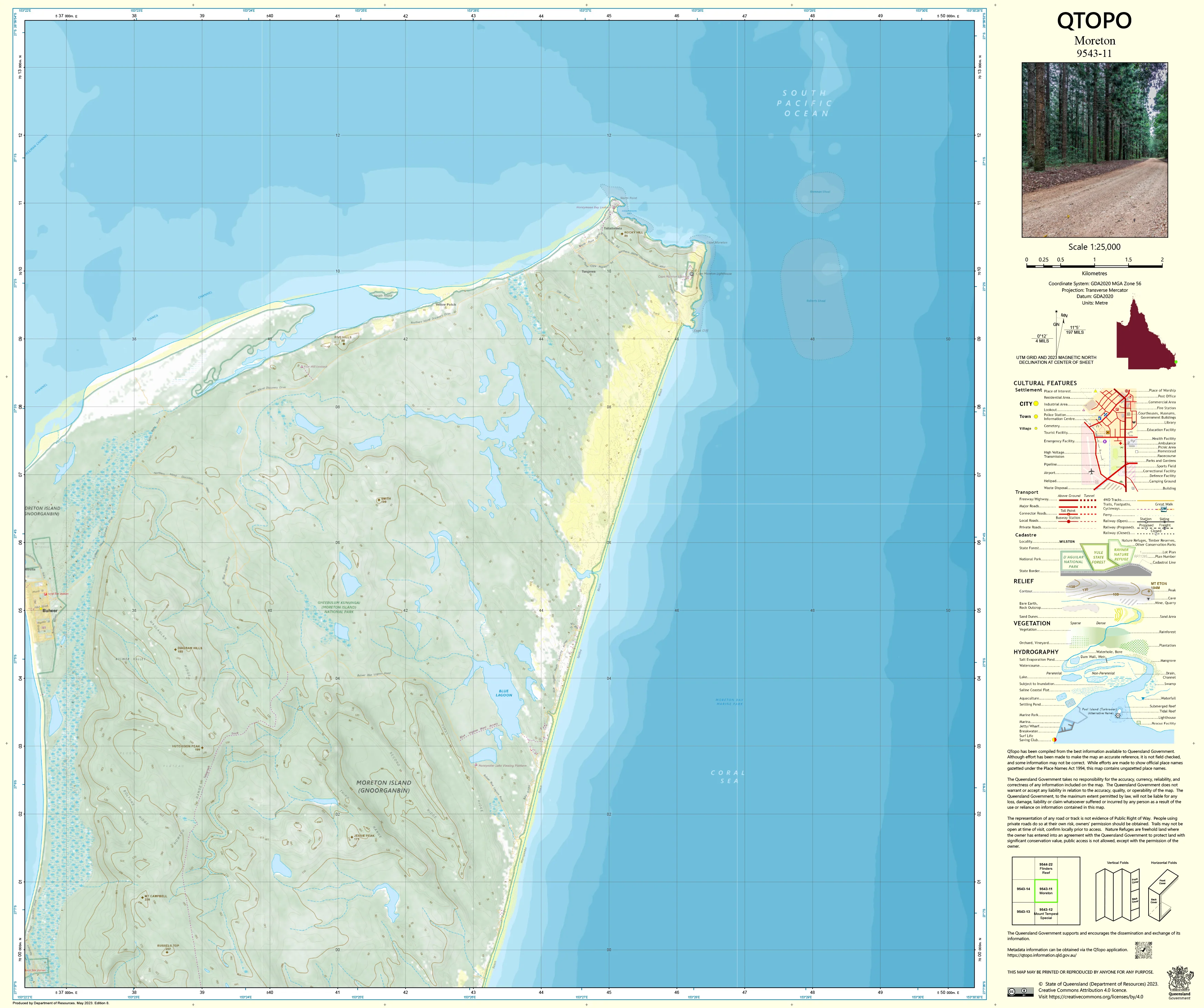
9543-11 Moreton QTopo 1:25,000 Topographic Map
QTopo 9543-11 — Moreton
1:25,000 Topographic Map
A high-detail topographic map covering the Moreton region—an area defined by its coastal landscapes, tidal channels, wetlands, estuarine systems, marine navigation zones, and low-lying terrain. As part of the Southern Moreton Bay network, this region is of major importance for environmental management, coastal planning, flood modelling, and marine operations.
The QTopo 9543-11 (Moreton) sheet—produced by the Queensland Department of Resources—is part of the authoritative 1:25,000 topographic mapping series. It delivers precise contouring, hydrology and tidal mapping, navigation features, vegetation structure, and land-use detail across one of Southeast Queensland’s most environmentally sensitive coastal and marine areas.
Whether you’re assessing coastal change, managing wetlands, navigating tidal channels, or conducting environmental fieldwork, QTopo 9543-11 offers the clarity, consistency, and accuracy needed for reliable decision-making.
🗺️ Map Content and Features
At 1:25,000 scale—where 1 cm equals 250 m—this map includes:
-
Contour lines suitable for low-elevation coastal terrain, shoals, islands, and tidal margins
-
Hydrology & marine features: tidal flats, mangrove systems, channels, creeks, estuarine zones, wetlands, and intertidal areas
-
Navigation & boating detail: marked channels, access routes, coastal edges, and shallow-water indicators
-
Infrastructure such as jetties, pontoons, powerlines, marine markers, fencelines, service facilities, and built areas where present
-
Vegetation mapping identifying mangroves, saltmarsh, wetland complexes, coastal shrubland, and conservation areas
-
Land tenure boundaries: national parks, conservation zones, council reserves, freehold parcels, and tidal boundaries
-
Named features including islands, coastal sectors, sandbanks, navigation points, and locality identifiers
-
Points of interest for marine users, ecologists, planners, emergency services, and coastal researchers
All QTopo sheets use Queensland’s authoritative spatial datasets for dependable, high-precision mapping.
🧭 Who Uses This Map?
The Moreton 9543-11 Topographic Map is commonly used by:
-
Environmental scientists & ecologists – wetland surveys, tidal mapping, habitat studies
-
Marine & boating users – navigating shallow waters and tidal channels
-
Coastal planners & surveyors – shoreline analysis, erosion assessment, landform evaluation
-
Emergency services & SES – storm-surge planning, flood response, marine operations
-
Conservation managers – monitoring mangroves, seabird habitats, and protected coastal areas
-
Educators & students – coastal geography, hydrology, and environmental sciences
A vital resource for accurate mapping across a dynamic and constantly evolving coastline.
💧 Field-Ready Options for Coastal, Marine & Wetland Terrain
Choose a finish engineered for harsh coastal and tidal environments.
✅ Waterproof & Tearproof Tyvek®
-
Printed on DuPont™ Tyvek®
-
Fully waterproof and tear-resistant
-
Ideal for marine operations, wetland studies, and all-weather fieldwork
✅ Laminated Edition
-
Encapsulated in 2 × 80-micron gloss laminate
-
Writeable surface for whiteboard markers
-
Resistant to salt spray, moisture, oils, and heavy handling
📄 Standard Paper Edition
-
High-resolution print
-
Best for office planning, study, and archival use
📐 Map Details
Title: QTopo 9543-11 — Moreton
Publisher: Queensland Department of Resources
Series: QTopo 1:25,000
Scale: 1:25,000 (1 cm = 250 m)
Dimensions: 710 mm (width) × 594 mm (height)
Coverage: Coastal and estuarine sections of the Moreton region, tidal flats, channels, wetlands, and nearby island environments
Material Options: Paper, laminated, or waterproof Tyvek®
Printed in: Australia
Edition: Latest available (see listing)
📥 QTopo Map Index
Need adjoining coastal or bay-region sheets?
➡️ Provide nearby sheet numbers—such as 9543-12, 9542-41, or 9443-11—and I’ll identify all adjoining maps instantly.
🛒 Ordering & Options
-
Standard folded paper map – ideal for coastal planning and desk reference
-
Tyvek® waterproof edition – perfect for marine and wetland fieldwork
-
Laminated edition – reusable, durable, and suitable for operational environments
-
Flat (unfolded) maps available for wall mounting or marine-planning boards
🎯 Summary
The QTopo 9543-11 — Moreton Topographic Map provides essential detail on hydrology, tidal systems, terrain, navigation, and environmental features across one of Southeast Queensland’s most important coastal landscapes. With authoritative 1:25,000 mapping and rugged print options, it is indispensable for ecologists, marine users, planners, emergency teams, and conservation managers.
Plan with purpose.
Navigate with confidence.
Explore with clarity.
Choose your preferred finish today and take the Moreton QTopo map into the field with Queensland’s most trusted topographic mapping.
Original: $14.27
-65%$14.27
$4.99Product Information
Product Information
Shipping & Returns
Shipping & Returns
Description
QTopo 9543-11 — Moreton
1:25,000 Topographic Map
A high-detail topographic map covering the Moreton region—an area defined by its coastal landscapes, tidal channels, wetlands, estuarine systems, marine navigation zones, and low-lying terrain. As part of the Southern Moreton Bay network, this region is of major importance for environmental management, coastal planning, flood modelling, and marine operations.
The QTopo 9543-11 (Moreton) sheet—produced by the Queensland Department of Resources—is part of the authoritative 1:25,000 topographic mapping series. It delivers precise contouring, hydrology and tidal mapping, navigation features, vegetation structure, and land-use detail across one of Southeast Queensland’s most environmentally sensitive coastal and marine areas.
Whether you’re assessing coastal change, managing wetlands, navigating tidal channels, or conducting environmental fieldwork, QTopo 9543-11 offers the clarity, consistency, and accuracy needed for reliable decision-making.
🗺️ Map Content and Features
At 1:25,000 scale—where 1 cm equals 250 m—this map includes:
-
Contour lines suitable for low-elevation coastal terrain, shoals, islands, and tidal margins
-
Hydrology & marine features: tidal flats, mangrove systems, channels, creeks, estuarine zones, wetlands, and intertidal areas
-
Navigation & boating detail: marked channels, access routes, coastal edges, and shallow-water indicators
-
Infrastructure such as jetties, pontoons, powerlines, marine markers, fencelines, service facilities, and built areas where present
-
Vegetation mapping identifying mangroves, saltmarsh, wetland complexes, coastal shrubland, and conservation areas
-
Land tenure boundaries: national parks, conservation zones, council reserves, freehold parcels, and tidal boundaries
-
Named features including islands, coastal sectors, sandbanks, navigation points, and locality identifiers
-
Points of interest for marine users, ecologists, planners, emergency services, and coastal researchers
All QTopo sheets use Queensland’s authoritative spatial datasets for dependable, high-precision mapping.
🧭 Who Uses This Map?
The Moreton 9543-11 Topographic Map is commonly used by:
-
Environmental scientists & ecologists – wetland surveys, tidal mapping, habitat studies
-
Marine & boating users – navigating shallow waters and tidal channels
-
Coastal planners & surveyors – shoreline analysis, erosion assessment, landform evaluation
-
Emergency services & SES – storm-surge planning, flood response, marine operations
-
Conservation managers – monitoring mangroves, seabird habitats, and protected coastal areas
-
Educators & students – coastal geography, hydrology, and environmental sciences
A vital resource for accurate mapping across a dynamic and constantly evolving coastline.
💧 Field-Ready Options for Coastal, Marine & Wetland Terrain
Choose a finish engineered for harsh coastal and tidal environments.
✅ Waterproof & Tearproof Tyvek®
-
Printed on DuPont™ Tyvek®
-
Fully waterproof and tear-resistant
-
Ideal for marine operations, wetland studies, and all-weather fieldwork
✅ Laminated Edition
-
Encapsulated in 2 × 80-micron gloss laminate
-
Writeable surface for whiteboard markers
-
Resistant to salt spray, moisture, oils, and heavy handling
📄 Standard Paper Edition
-
High-resolution print
-
Best for office planning, study, and archival use
📐 Map Details
Title: QTopo 9543-11 — Moreton
Publisher: Queensland Department of Resources
Series: QTopo 1:25,000
Scale: 1:25,000 (1 cm = 250 m)
Dimensions: 710 mm (width) × 594 mm (height)
Coverage: Coastal and estuarine sections of the Moreton region, tidal flats, channels, wetlands, and nearby island environments
Material Options: Paper, laminated, or waterproof Tyvek®
Printed in: Australia
Edition: Latest available (see listing)
📥 QTopo Map Index
Need adjoining coastal or bay-region sheets?
➡️ Provide nearby sheet numbers—such as 9543-12, 9542-41, or 9443-11—and I’ll identify all adjoining maps instantly.
🛒 Ordering & Options
-
Standard folded paper map – ideal for coastal planning and desk reference
-
Tyvek® waterproof edition – perfect for marine and wetland fieldwork
-
Laminated edition – reusable, durable, and suitable for operational environments
-
Flat (unfolded) maps available for wall mounting or marine-planning boards
🎯 Summary
The QTopo 9543-11 — Moreton Topographic Map provides essential detail on hydrology, tidal systems, terrain, navigation, and environmental features across one of Southeast Queensland’s most important coastal landscapes. With authoritative 1:25,000 mapping and rugged print options, it is indispensable for ecologists, marine users, planners, emergency teams, and conservation managers.
Plan with purpose.
Navigate with confidence.
Explore with clarity.
Choose your preferred finish today and take the Moreton QTopo map into the field with Queensland’s most trusted topographic mapping.


