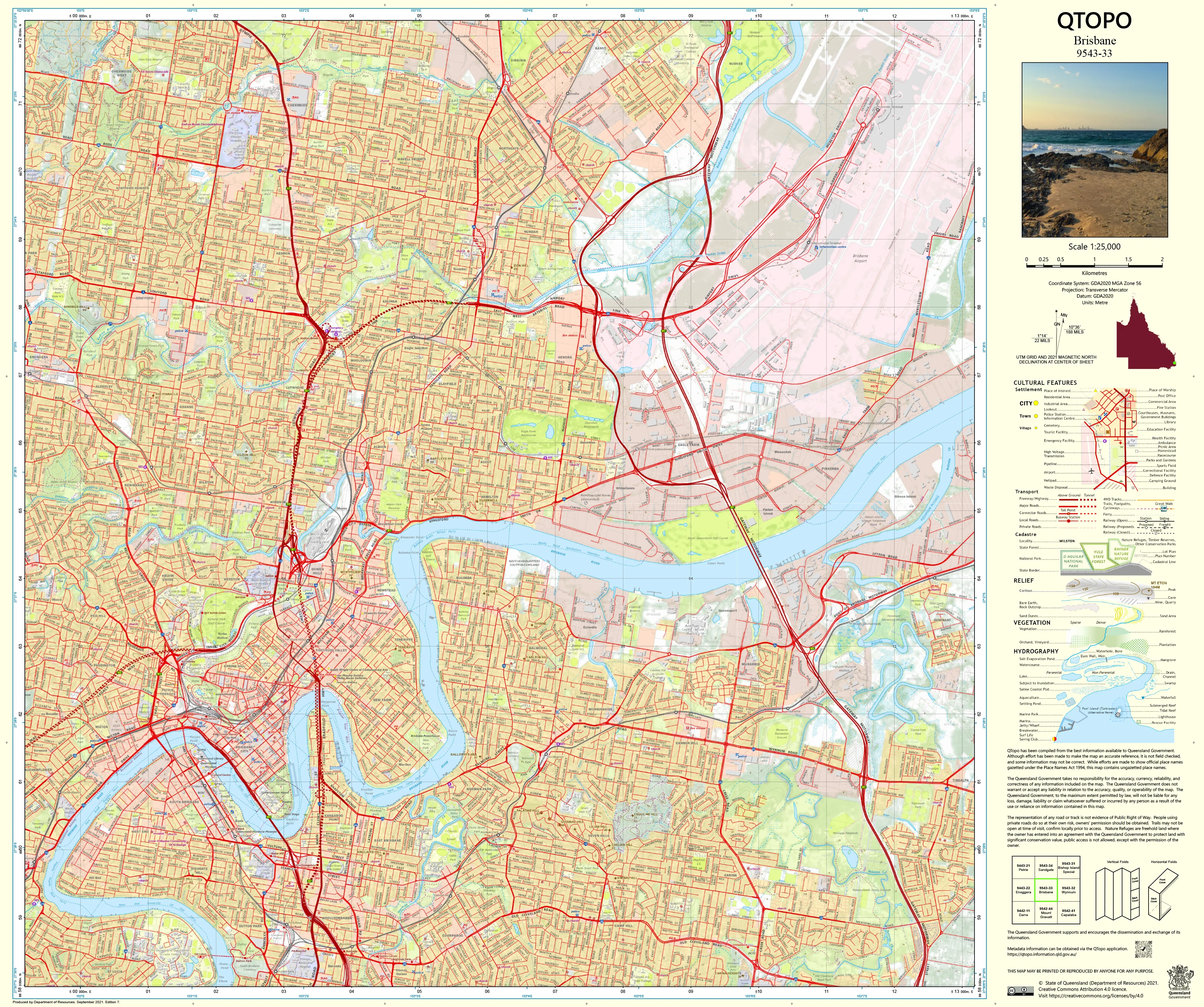
9543-33 Brisbane QTopo 1:25,000 Topographic Map
QTopo 9543-33 — Brisbane
1:25,000 Topographic Map
A comprehensive and authoritative topographic map covering Brisbane, Queensland’s capital city—an urban landscape shaped by the winding Brisbane River, steep inner-city ridgelines, dense suburban development, coastal wetlands, transport corridors, and expansive parklands. With its blend of complex infrastructure, flood-sensitive catchments, elevated suburbs, and high-density activity centres, Brisbane demands precise mapping for planning, engineering, environmental analysis, and emergency management.
The QTopo 9543-33 (Brisbane) sheet—produced by the Queensland Department of Resources—is part of Queensland’s official 1:25,000 topographic mapping series. It provides exceptional detail across metropolitan Brisbane, delivering accurate contours, hydrology modelling, vegetation structure, transport networks, and land-use boundaries.
Whether you're assessing flood risk, analysing development constraints, navigating suburban corridors, or conducting detailed urban studies, QTopo 9543-33 gives you the clarity and confidence required to interpret one of Australia’s most complex city landscapes.
🗺️ Map Content and Features
At 1:25,000 scale—where 1 cm equals 250 m—this map includes:
-
Contour lines showing ridgelines, steep inner-city hills, valley floors, escarpments, and slope variations
-
Hydrology features: Brisbane River, tributaries, stormwater channels, wetlands, flood zones, and drainage networks
-
Transport networks including major arterials, motorways, suburban road grids, busways, rail lines, bikeways, and bridges
-
Infrastructure such as hospitals, schools, universities, industrial areas, reservoirs, powerlines, sporting complexes, and government precincts
-
Vegetation & land cover mapping conservation reserves, bushland pockets, riverbank vegetation, parks, and cleared urban land
-
Land tenure boundaries: freehold parcels, council reserves, state land, transport easements, utilities, and institutional campuses
-
Named features including hills, suburbs, river crossings, parks, civic centres, and natural landmarks
-
Points of interest for planners, surveyors, engineers, emergency responders, educators, and local communities
All QTopo maps draw from Queensland’s authoritative geospatial datasets for highly reliable accuracy.
🧭 Who Uses This Map?
The Brisbane 9543-33 Topographic Map is essential for:
-
Urban planners & surveyors – development assessment, zoning analysis, slope and drainage modelling
-
Environmental scientists & ecologists – catchment studies, floodplain research, habitat monitoring
-
Emergency services & SES – flood response, storm planning, evacuation modelling
-
Civil engineers & infrastructure teams – road planning, project design, service alignment
-
Utility providers – infrastructure mapping, corridor planning, asset management
-
Researchers, educators & students – urban geography, hydrology, landform studies
-
Residents & community groups – understanding local terrain, waterways, and natural features
A vital tool for anyone working with Brisbane’s urban and environmental systems.
💧 Field-Ready Options for Urban, River & Infrastructure Environments
Choose a finish suited to Brisbane’s diverse city and creek-corridor conditions.
✅ Waterproof & Tearproof Tyvek®
-
Printed on DuPont™ Tyvek®
-
Completely waterproof, tear-resistant, and durable
-
Ideal for field inspections, flood mapping, and all-weather urban studies
✅ Laminated Edition
-
Encapsulated in 2 × 80-micron gloss laminate
-
Writeable surface accepts whiteboard markers
-
Resistant to moisture, oils, dirt, and frequent handling
📄 Standard Paper Edition
-
Crisp, high-resolution print
-
Excellent for planning, reports, mapping projects, and education
📐 Map Details
Title: QTopo 9543-33 — Brisbane
Publisher: Queensland Department of Resources
Series: QTopo 1:25,000
Scale: 1:25,000 (1 cm = 250 m)
Dimensions: 710 mm (width) × 594 mm (height)
Coverage: Central and suburban Brisbane, Brisbane River corridor, urban hills, transport networks, conservation land, and major civic and industrial precincts
Material Options: Paper, laminated, or waterproof Tyvek®
Printed in: Australia
Edition: Latest available (see listing)
📥 QTopo Map Index
Need adjoining metropolitan or river-corridor sheets?
➡️ Provide nearby sheet numbers—such as 9543-12, 9543-34, or 9443-33—and I’ll identify all adjoining maps instantly.
🛒 Ordering & Options
-
Standard folded paper map – ideal for planning, reference, and education
-
Tyvek® waterproof edition – perfect for floodplain studies and outdoor inspections
-
Laminated edition – reusable, durable, and suitable for operational environments
-
Flat (unfolded) maps available for wall display, planning boards, and project rooms
🎯 Summary
The QTopo 9543-33 — Brisbane Topographic Map provides essential, city-wide detail on terrain, hydrology, infrastructure, access networks, and land use across the Queensland capital. With authoritative 1:25,000 mapping and durable print options, it is indispensable for surveyors, planners, ecologists, engineers, emergency teams, and urban researchers.
Plan with purpose.
Navigate with confidence.
Explore with clarity.
Choose your preferred finish today and take the Brisbane QTopo map into the field with Queensland’s most trusted topographic mapping.
Original: $14.27
-65%$14.27
$4.99Product Information
Product Information
Shipping & Returns
Shipping & Returns
Description
QTopo 9543-33 — Brisbane
1:25,000 Topographic Map
A comprehensive and authoritative topographic map covering Brisbane, Queensland’s capital city—an urban landscape shaped by the winding Brisbane River, steep inner-city ridgelines, dense suburban development, coastal wetlands, transport corridors, and expansive parklands. With its blend of complex infrastructure, flood-sensitive catchments, elevated suburbs, and high-density activity centres, Brisbane demands precise mapping for planning, engineering, environmental analysis, and emergency management.
The QTopo 9543-33 (Brisbane) sheet—produced by the Queensland Department of Resources—is part of Queensland’s official 1:25,000 topographic mapping series. It provides exceptional detail across metropolitan Brisbane, delivering accurate contours, hydrology modelling, vegetation structure, transport networks, and land-use boundaries.
Whether you're assessing flood risk, analysing development constraints, navigating suburban corridors, or conducting detailed urban studies, QTopo 9543-33 gives you the clarity and confidence required to interpret one of Australia’s most complex city landscapes.
🗺️ Map Content and Features
At 1:25,000 scale—where 1 cm equals 250 m—this map includes:
-
Contour lines showing ridgelines, steep inner-city hills, valley floors, escarpments, and slope variations
-
Hydrology features: Brisbane River, tributaries, stormwater channels, wetlands, flood zones, and drainage networks
-
Transport networks including major arterials, motorways, suburban road grids, busways, rail lines, bikeways, and bridges
-
Infrastructure such as hospitals, schools, universities, industrial areas, reservoirs, powerlines, sporting complexes, and government precincts
-
Vegetation & land cover mapping conservation reserves, bushland pockets, riverbank vegetation, parks, and cleared urban land
-
Land tenure boundaries: freehold parcels, council reserves, state land, transport easements, utilities, and institutional campuses
-
Named features including hills, suburbs, river crossings, parks, civic centres, and natural landmarks
-
Points of interest for planners, surveyors, engineers, emergency responders, educators, and local communities
All QTopo maps draw from Queensland’s authoritative geospatial datasets for highly reliable accuracy.
🧭 Who Uses This Map?
The Brisbane 9543-33 Topographic Map is essential for:
-
Urban planners & surveyors – development assessment, zoning analysis, slope and drainage modelling
-
Environmental scientists & ecologists – catchment studies, floodplain research, habitat monitoring
-
Emergency services & SES – flood response, storm planning, evacuation modelling
-
Civil engineers & infrastructure teams – road planning, project design, service alignment
-
Utility providers – infrastructure mapping, corridor planning, asset management
-
Researchers, educators & students – urban geography, hydrology, landform studies
-
Residents & community groups – understanding local terrain, waterways, and natural features
A vital tool for anyone working with Brisbane’s urban and environmental systems.
💧 Field-Ready Options for Urban, River & Infrastructure Environments
Choose a finish suited to Brisbane’s diverse city and creek-corridor conditions.
✅ Waterproof & Tearproof Tyvek®
-
Printed on DuPont™ Tyvek®
-
Completely waterproof, tear-resistant, and durable
-
Ideal for field inspections, flood mapping, and all-weather urban studies
✅ Laminated Edition
-
Encapsulated in 2 × 80-micron gloss laminate
-
Writeable surface accepts whiteboard markers
-
Resistant to moisture, oils, dirt, and frequent handling
📄 Standard Paper Edition
-
Crisp, high-resolution print
-
Excellent for planning, reports, mapping projects, and education
📐 Map Details
Title: QTopo 9543-33 — Brisbane
Publisher: Queensland Department of Resources
Series: QTopo 1:25,000
Scale: 1:25,000 (1 cm = 250 m)
Dimensions: 710 mm (width) × 594 mm (height)
Coverage: Central and suburban Brisbane, Brisbane River corridor, urban hills, transport networks, conservation land, and major civic and industrial precincts
Material Options: Paper, laminated, or waterproof Tyvek®
Printed in: Australia
Edition: Latest available (see listing)
📥 QTopo Map Index
Need adjoining metropolitan or river-corridor sheets?
➡️ Provide nearby sheet numbers—such as 9543-12, 9543-34, or 9443-33—and I’ll identify all adjoining maps instantly.
🛒 Ordering & Options
-
Standard folded paper map – ideal for planning, reference, and education
-
Tyvek® waterproof edition – perfect for floodplain studies and outdoor inspections
-
Laminated edition – reusable, durable, and suitable for operational environments
-
Flat (unfolded) maps available for wall display, planning boards, and project rooms
🎯 Summary
The QTopo 9543-33 — Brisbane Topographic Map provides essential, city-wide detail on terrain, hydrology, infrastructure, access networks, and land use across the Queensland capital. With authoritative 1:25,000 mapping and durable print options, it is indispensable for surveyors, planners, ecologists, engineers, emergency teams, and urban researchers.
Plan with purpose.
Navigate with confidence.
Explore with clarity.
Choose your preferred finish today and take the Brisbane QTopo map into the field with Queensland’s most trusted topographic mapping.


