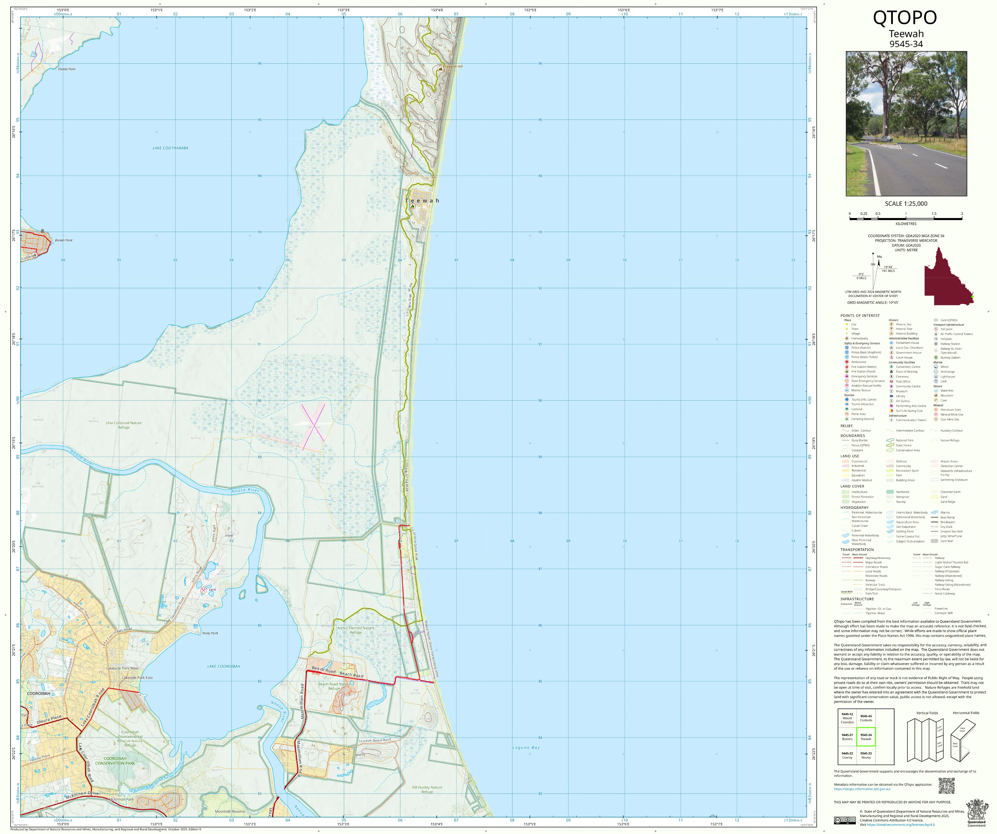
9545-34 Teewah QTopo 1:25,000 Topographic Map
QTopo 9545-34 — Teewah
1:25,000 Topographic Map
A highly detailed topographic map covering Teewah, a spectacular stretch of coastline renowned for its sweeping beaches, high dune systems, freshwater lakes, wild bushland, and access to Great Sandy National Park. This region’s combination of dynamic coastal processes, remote sand tracks, dune escarpments, and environmentally sensitive wetlands makes accurate mapping essential for safe navigation, conservation work, emergency management, and recreational exploration.
The QTopo 9545-34 (Teewah) sheet—produced by the Queensland Department of Resources—is part of the authoritative 1:25,000 topographic series. It provides clear elevation contours, hydrology networks, vegetation patterns, coastal features, and access routes across one of the Sunshine Coast’s most dramatic and wild coastal landscapes.
Whether you're driving the Teewah Beach 4WD route, studying coastal changes, managing conservation areas, or exploring the region’s lakes and dune systems, QTopo 9545-34 delivers the precision and clarity required.
🗺️ Map Content and Features
At 1:25,000 scale—with 1 cm representing 250 m—this map includes:
-
Contour lines detailing sand dunes, dune crests, escarpments, coastal ridges, and lake margins
-
Hydrology features: freshwater lakes, perched lake systems, wetlands, creeks, swamps, and drainage lines
-
Coastal & marine detail including beach gradients, shoreline position, tidal flats, surf-side terrain, and nearshore patterns
-
Access routes: beach-driving corridors, 4WD sand tracks, inland management tracks, and connection points to Great Sandy NP
-
Infrastructure such as camping zones, access points, fencelines, management gates, water facilities, and lookout areas
-
Vegetation mapping identifying coastal heath, woodland, forest pockets, dune vegetation, wetlands, and shrublands
-
Land tenure boundaries including national park, recreation areas, council reserves, and limited freehold parcels
-
Named features including Teewah, Noosa North Shore, Lake Cootharaba margins, dune fields, and local natural landmarks
-
Points of interest for ecologists, park rangers, emergency crews, 4WD drivers, hikers, and coastal researchers
All QTopo maps draw from Queensland’s authoritative spatial datasets to ensure dependable accuracy.
🧭 Who Uses This Map?
The Teewah 9545-34 Topographic Map is widely used by:
-
Environmental scientists & ecologists – dune system studies, wetland assessments, habitat monitoring
-
Rangers & land managers – national park management, track maintenance, visitor planning
-
Emergency services & SES – search & rescue, wildfire response, storm event analysis
-
4WD drivers & beach campers – navigating beach access points, safe driving zones, and camping areas
-
Hikers & explorers – inland track navigation and lake-region exploration
-
Coastal planners & surveyors – shoreline monitoring, terrain analysis, environmental impact work
-
Educators & students – coastal geomorphology, hydrology, and environmental science
A critical tool for both professional and recreational users in this remote coastal region.
💧 Field-Ready Options for Beach, Dune & Coastal Terrain
Choose a finish designed to withstand the harsh coastal conditions typical of Teewah.
✅ Waterproof & Tearproof Tyvek®
-
Printed on DuPont™ Tyvek®
-
Fully waterproof, durable, and tear-resistant
-
Ideal for beach navigation, wetland mapping, and all-weather fieldwork
✅ Laminated Edition
-
Encapsulated in 2 × 80-micron gloss laminate
-
Writeable surface supports whiteboard markers
-
Resistant to salt spray, moisture, sand, oils, and repeated handling
📄 Standard Paper Edition
-
Crisp, high-resolution printing
-
Suitable for planning, education, and office use
📐 Map Details
Title: QTopo 9545-34 — Teewah
Publisher: Queensland Department of Resources
Series: QTopo 1:25,000
Scale: 1:25,000 (1 cm = 250 m)
Dimensions: 710 mm (width) × 594 mm (height)
Coverage: Teewah coast, dune systems, beach-driving corridors, wetlands, lakes, and adjoining areas of Great Sandy National Park
Material Options: Paper, laminated, or waterproof Tyvek®
Printed in: Australia
Edition: Latest available (see listing)
📥 QTopo Map Index
Need adjoining Sunshine Coast, Noosa North Shore, or Great Sandy NP sheets?
➡️ Provide nearby sheet numbers—such as 9545-24, 9545-33, or 9445-34—and I’ll identify the adjoining maps instantly.
🛒 Ordering & Options
-
Standard folded paper map – ideal for planning and study
-
Tyvek® waterproof edition – perfect for beach and dune conditions
-
Laminated edition – rugged, reusable, and ideal for operational or recreational field use
-
Flat (unfolded) maps available for wall display or navigation boards
🎯 Summary
The QTopo 9545-34 — Teewah Topographic Map provides high-accuracy detail on terrain, hydrology, coastal systems, vegetation, and access across one of Queensland’s most iconic and challenging coastal environments. With authoritative 1:25,000 mapping and durable print options, it is indispensable for rangers, ecologists, 4WD travellers, emergency teams, planners, and coastal researchers.
Plan with purpose.
Navigate with confidence.
Explore with clarity.
Choose your preferred finish today and take the Teewah QTopo map into the field with Queensland’s most trusted topographic mapping.
Original: $21.43
-65%$21.43
$7.50Product Information
Product Information
Shipping & Returns
Shipping & Returns
Description
QTopo 9545-34 — Teewah
1:25,000 Topographic Map
A highly detailed topographic map covering Teewah, a spectacular stretch of coastline renowned for its sweeping beaches, high dune systems, freshwater lakes, wild bushland, and access to Great Sandy National Park. This region’s combination of dynamic coastal processes, remote sand tracks, dune escarpments, and environmentally sensitive wetlands makes accurate mapping essential for safe navigation, conservation work, emergency management, and recreational exploration.
The QTopo 9545-34 (Teewah) sheet—produced by the Queensland Department of Resources—is part of the authoritative 1:25,000 topographic series. It provides clear elevation contours, hydrology networks, vegetation patterns, coastal features, and access routes across one of the Sunshine Coast’s most dramatic and wild coastal landscapes.
Whether you're driving the Teewah Beach 4WD route, studying coastal changes, managing conservation areas, or exploring the region’s lakes and dune systems, QTopo 9545-34 delivers the precision and clarity required.
🗺️ Map Content and Features
At 1:25,000 scale—with 1 cm representing 250 m—this map includes:
-
Contour lines detailing sand dunes, dune crests, escarpments, coastal ridges, and lake margins
-
Hydrology features: freshwater lakes, perched lake systems, wetlands, creeks, swamps, and drainage lines
-
Coastal & marine detail including beach gradients, shoreline position, tidal flats, surf-side terrain, and nearshore patterns
-
Access routes: beach-driving corridors, 4WD sand tracks, inland management tracks, and connection points to Great Sandy NP
-
Infrastructure such as camping zones, access points, fencelines, management gates, water facilities, and lookout areas
-
Vegetation mapping identifying coastal heath, woodland, forest pockets, dune vegetation, wetlands, and shrublands
-
Land tenure boundaries including national park, recreation areas, council reserves, and limited freehold parcels
-
Named features including Teewah, Noosa North Shore, Lake Cootharaba margins, dune fields, and local natural landmarks
-
Points of interest for ecologists, park rangers, emergency crews, 4WD drivers, hikers, and coastal researchers
All QTopo maps draw from Queensland’s authoritative spatial datasets to ensure dependable accuracy.
🧭 Who Uses This Map?
The Teewah 9545-34 Topographic Map is widely used by:
-
Environmental scientists & ecologists – dune system studies, wetland assessments, habitat monitoring
-
Rangers & land managers – national park management, track maintenance, visitor planning
-
Emergency services & SES – search & rescue, wildfire response, storm event analysis
-
4WD drivers & beach campers – navigating beach access points, safe driving zones, and camping areas
-
Hikers & explorers – inland track navigation and lake-region exploration
-
Coastal planners & surveyors – shoreline monitoring, terrain analysis, environmental impact work
-
Educators & students – coastal geomorphology, hydrology, and environmental science
A critical tool for both professional and recreational users in this remote coastal region.
💧 Field-Ready Options for Beach, Dune & Coastal Terrain
Choose a finish designed to withstand the harsh coastal conditions typical of Teewah.
✅ Waterproof & Tearproof Tyvek®
-
Printed on DuPont™ Tyvek®
-
Fully waterproof, durable, and tear-resistant
-
Ideal for beach navigation, wetland mapping, and all-weather fieldwork
✅ Laminated Edition
-
Encapsulated in 2 × 80-micron gloss laminate
-
Writeable surface supports whiteboard markers
-
Resistant to salt spray, moisture, sand, oils, and repeated handling
📄 Standard Paper Edition
-
Crisp, high-resolution printing
-
Suitable for planning, education, and office use
📐 Map Details
Title: QTopo 9545-34 — Teewah
Publisher: Queensland Department of Resources
Series: QTopo 1:25,000
Scale: 1:25,000 (1 cm = 250 m)
Dimensions: 710 mm (width) × 594 mm (height)
Coverage: Teewah coast, dune systems, beach-driving corridors, wetlands, lakes, and adjoining areas of Great Sandy National Park
Material Options: Paper, laminated, or waterproof Tyvek®
Printed in: Australia
Edition: Latest available (see listing)
📥 QTopo Map Index
Need adjoining Sunshine Coast, Noosa North Shore, or Great Sandy NP sheets?
➡️ Provide nearby sheet numbers—such as 9545-24, 9545-33, or 9445-34—and I’ll identify the adjoining maps instantly.
🛒 Ordering & Options
-
Standard folded paper map – ideal for planning and study
-
Tyvek® waterproof edition – perfect for beach and dune conditions
-
Laminated edition – rugged, reusable, and ideal for operational or recreational field use
-
Flat (unfolded) maps available for wall display or navigation boards
🎯 Summary
The QTopo 9545-34 — Teewah Topographic Map provides high-accuracy detail on terrain, hydrology, coastal systems, vegetation, and access across one of Queensland’s most iconic and challenging coastal environments. With authoritative 1:25,000 mapping and durable print options, it is indispensable for rangers, ecologists, 4WD travellers, emergency teams, planners, and coastal researchers.
Plan with purpose.
Navigate with confidence.
Explore with clarity.
Choose your preferred finish today and take the Teewah QTopo map into the field with Queensland’s most trusted topographic mapping.


